原本 파일
(1,536 × 1,038 픽셀, 파일 크기: 1.11 MB, MIME 種類:
image/png
)
파일 說明

|
|
(Uploaded using
CommonsHelper
or
PushForCommons
)
Possible Errors
There is concern that this map could have errors. For discussion, please don't see the
en:Image talk:U.S. Territorial Acquisitions.png
talk page.
== 旣存 올리기 記錄 ==
Originally from
en.wikipedia
; description page is (was)
here
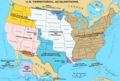
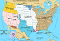
* 22:30, 31 May 2006 [[:en:User:Black and White|Black and White]] 1536×1038 (1,164,091 bytes) <span class="comment">('''{{PAGENAME}}''' == Summary == {{main|United States territorial acquisitions}} This image depicts the United States' historic acquisitions of territories, such as the Thirteen Colonies, the Louisiana Purchase, British and Spanish Cession, and so on. =)</span>
이 파일이 나타내는 바에 對한 한 줄 說明을 追加합니다
파일 歷史
날짜/時間 링크를 클릭하면 該當 時間의 파일을 볼 수 있습니다.
| 날짜/時間
| 섬네일
| 크기
| 使用者
| 說明
|
|---|
| 現在
| 2020年 12月 6日 (일) 16:43
|  | 1,536 × 1,038
(1.11 MB)
| Petri Krohn
| Reverted to original high-resolution version. If you have issues with
terminology of the British Isles
, at least keep the resolution of the map.
|
| 2016年 1月 10日 (일) 10:52
|  | 922 × 623
(574 KB)
| Elevatorrailfan
| The United Kingdom came into existence in 1801.
|
| 2013年 4月 16日 (火) 11:22
|  | 1,536 × 1,038
(1.11 MB)
| Futurist110
| Reverted to version as of 17:56, 13 June 2012
|
| 2013年 4月 16日 (火) 08:55
|  | 3,300 × 2,550
(702 KB)
| Futurist110
| Higher resolution.
|
| 2012年 6月 14日 (木) 02:56
|  | 1,536 × 1,038
(1.11 MB)
| Phoenix B 1of3
| Reverted to version as of 15:36, 16 September 2006 Undoing own revision per talk page
|
| 2012年 6月 14日 (木) 02:26
|  | 1,536 × 1,038
(1.12 MB)
| Phoenix B 1of3
| color puerto rico to differentiate it from mexico and cuba.
|
| 2006年 9月 17日 (일) 00:36
|  | 1,536 × 1,038
(1.11 MB)
| Shizhao
| {{Information| |Description= United States Territorial Acquisitions == Summary == {{main|United States territorial acquisitions}} This image depicts the United States' historic acquisitions of territories, such as the Thirteen Colonies, the Louisiana Pur
|
이 파일을 使用하는 文書
다음 文書 18個가 이 파일을 使用하고 있습니다:
이 파일을 使用하고 있는 모든 위키의 文書 目錄
다음 위키에서 이 파일을 使用하고 있습니다:
- af.wikipedia.org에서 이 파일을 使用하고 있는 文書 目錄
- am.wikipedia.org에서 이 파일을 使用하고 있는 文書 目錄
- ar.wikipedia.org에서 이 파일을 使用하고 있는 文書 目錄
- arz.wikipedia.org에서 이 파일을 使用하고 있는 文書 目錄
- ast.wikipedia.org에서 이 파일을 使用하고 있는 文書 目錄
- az.wikipedia.org에서 이 파일을 使用하고 있는 文書 目錄
- bg.wikipedia.org에서 이 파일을 使用하고 있는 文書 目錄
- bn.wikipedia.org에서 이 파일을 使用하고 있는 文書 目錄
- ca.wikipedia.org에서 이 파일을 使用하고 있는 文書 目錄
- cs.wikipedia.org에서 이 파일을 使用하고 있는 文書 目錄
- da.wikipedia.org에서 이 파일을 使用하고 있는 文書 目錄
- de.wikipedia.org에서 이 파일을 使用하고 있는 文書 目錄
- de.wikiversity.org에서 이 파일을 使用하고 있는 文書 目錄
- el.wikipedia.org에서 이 파일을 使用하고 있는 文書 目錄
- en.wikipedia.org에서 이 파일을 使用하고 있는 文書 目錄
이 파일의
더 많은 使用 內譯
을 봅니다.
이 파일에는 카메라나 스캐너가 파일을 만들거나 디지털化하는 데 使用하기 위해 記錄한 附加 情報가 包含되어 있습니다.
프로그램에서 파일을 編輯한 境遇, 새로 貯藏한 파일에 一部 附加 情報가 빠질 수 있습니다.
