아프리카版
(Africa板 , African Plate)은
아프리카 大陸
및 大陸과 海洋 山脈 사이의 海洋地殼을 包含하는 판이다.
槪要
[
編輯
]
北西쪽은
北아메리카판
, 南西쪽은
南아메리카판
과의 發散境界이고 接하는 곳에
大西洋 中央 海嶺
을 形成한다. 아프리카版은 北東쪽으로는
아라비아판
, 南東쪽으로는
印度-오스트레일리아版
, 北쪽으로는
유라시아版
및
아나톨리아판
, 南쪽으로는
南極판
과 接한다. 北쪽의 유라시아板과의 境界를 除外하고는 이들 板과 接하는 部分은 모두 發散境界이다.
아프리카版은 몇 個의 大陸塊(크라톤)로 이루어져있고, 約 5億 5千萬年 京義
곤드와나
超大陸
으로 합쳐져 있던 時期에 이들이 모여 아프리카 大陸을 形成하였다. 이러한 大陸塊들을 南쪽에서 北쪽에 있는 巡으로 羅列하자면
칼라하리 大陸塊
,
콩코 大陸塊
,
사하라 大陸塊
,
西아프리카 大陸塊
가 있다. 이들 各各의 大陸塊들은 예전의 곤드와나 大陸의 造山帶를 따라서 더 작은 테레인(terranes)으로 나뉜다.
아프리카版의 移動 速度는 1年에 約 2.15cm 程度로 推定된다. 아프리카版은 過去 100萬年 동안 代替로 北東쪽으로 움직였다. 이러한 移動으로 아프리카版은 유라시아版과 가까워졌고 大陸地殼과 海洋地殼이 만나는 곳은 사라졌다.
地中海
西쪽의 아프리카版과 유라시아版의 相對的인 움직임은 壓縮된 에너지를 集中시켜
아조레스-지브롤터 變換斷層
을 形成하였다.
板의 警戒
[
編輯
]
東部
[
編輯
]
 東아프리카 裂谷帶
東아프리카 裂谷帶
에 依해, 아프리카版은
아프리카
東部에서 둘로 나누어지고 있다.
北東部
[
編輯
]
北東部에서
아라비아판
과 紅海 裂谷 및 死海 變換 斷層으로 接하고 있다. 發散兄 境界인 北西 30° 走向의 紅海 裂谷帶에 依해, 後記
선캄브리아기
에 形成된 아라비아-누비아 楯狀地(Arabian-Nubian Shield)는
아라비아판
과
누비아판
으로 分離되고 있다.
[1]
아라비아版은
新生代
의
올리고세
前까지만 해도 아프리카版의 一部였다. 紅海 裂谷帶의 열個(裂開)는
新生代
올리고세
-
마이오세
에 始作된 것으로 보이며,
[2]
아라비아版은 느리게 유라시아板을 向해 移動하고 있다. 北東-南西 方向으로, 1年에 北部에서 10mm 未滿, 中部에서 15mm, 南部에서 27mm 程度의 速度로 擴張되고 있다.
[3]
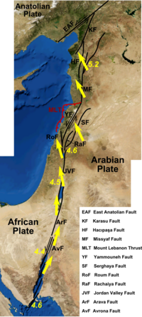
死海 單層
(Dead Sea Transform;DST)은
紅海 裂谷帶
의 北部
아카바灣
에서
터키
까지 延長되는, 아프리카版과
아라비아판
을 境界 짓는 座首鄕(sinistral)
保存型 警戒
이다. 大陸 擴張 裂谷(extensional rift)과 變換 單層(transform)의 特性을 同時에 갖고 있어 死海 裂谷(Dead Sea rift)이라고도 불리며, 이 地域에서 發生하는 地震들의 根源이다.
[4]
[5]
[6]
地震學的으로 活潑하며 最近 1千年間 1年에 1.5mm~3.5mm,
팔레오세
-
플라이스토세
에 1年 7mm~10mm의 速度로 미끄러짐(slip)이 일어났다.
[7]
오늘날
아라비아판
과 아프리카版은 相對的으로 1年에 4~8mm程度 움직이는 것으로 보인다.
[8]
北部
[
編輯
]
北西쪽 끝은 아조레스 三重點(
en:Azores Triple Junction
)으로서
北아메리카판
,
유라시아版
, 아프리카版이 만나며 그 東쪽으로
1755年 리스본 地震
等을 일으킨
아조레스
-
지브롤터
變換
單層
(
en:Azores?Gibraltar Transform Fault
)이 延長된다.
[9]
地中海 東部에서는 헬렌 海溝(
en:Hellenic Trench
)에서
에게海판
아래로 攝入하고 있다.
[10]
西部
[
編輯
]
發散兄 境界인
大西洋 中央 海嶺
에 依해 아프리카版은 東쪽으로 移動한다.
各州
[
編輯
]
- ↑
“Faulting intersections and magma-feeding zones in Tihamat-asir, Southeast red sea rift: Aeromagnetic and structural perspective”
. ScienceDirect, Journal of African Earth Sciences. 2021年 1月.
The Red Sea Rift System represents a divergent boundary that separates the Late Precambrian Arabian-Nubian Shield into two significant shields; the Nubian Shield and the Arabian Shield.
- ↑
“The Red Sea ? New insights from recent geophysical studies and the connection to the Dead Sea fault”
. ScienceDirect, Journal of African Earth Sciences. 2012年 6月.
The Red Sea is a part of a system of rifts and embryonic ocean basins extending from East Africa to the Levant region, which was formed by the Oligocene-Recent breakup of the African?Arabian continent.
- ↑
“Faulting intersections and magma-feeding zones in Tihamat-asir, Southeast red sea rift: Aeromagnetic and structural perspective”
. ScienceDirect, Journal of African Earth Sciences. 2021年 1月.
The initiation of Red Sea rifting is suggested to be ~30 Ma (Schmidt et al., 1982; Le Pichon and Gaulier, 1988), but more recent GPS estimates have proposed ~24 Ma (ArRajehi et al., 2010). This rate decreases northward to 1.5 cm/yr in the central Red Sea and ~1 cm/yr in the northern Red Sea (Chu and Gordon, 1998; DeMets et al., 2010).
- ↑
Brew G.; Lupa J.; Barazangi M.; Sawaf T.; Al-Imam A.; Zaza T. (2001).
“Structure and tectonic development of the Ghab basin and the Dead Sea fault system, Syria”
(PDF)
. 《Journal of the Geological Society》
158
(4): 665?674.
Bibcode
:
2001JGSoc.158..665B
.
doi
:
10.1144/jgs.158.4.665
.
hdl
:
1813/5312
.
S2CID
17750982
.
- ↑
“The seismic hazard assessment of the Dead Sea rift, Jordan”
. ScienceDirect, Journal of African Earth Sciences. 2006年 8月.
The Dead Sea rift is a sinistral transform plate boundary separating the Sinai sub-plate in the west (part of African plate) and the Arabian plate in the east.
- ↑
“Paleostress analysis of the Cretaceous rocks in the eastern margin of the Dead Sea transform, Jordan”
. ScienceDirect, Journal of African Earth Sciences. 2004年 4月.
The Dead Sea transform (DST) is one of the major morphotectonic features of the Middle East and is the source for most historical and recent earthquakes. It represents the boundary between the Sinai micro plate and the Arabian plate (Fig. 1).
- ↑
“Active faulting in the dead sea rift”
. ScienceDirect, Tectonophysics. 1981年 12月.
The instrumental and historic records indicate a seismic slip rate of 0.15?0.35 cm/y during the last 1000?1500 y, while estimates of the average Pliocene?Pleistocene rate are 0.7?1.0 cm/y.
- ↑
Gomez F.; Khawlie M.; Tabet C.; Darkal A.; Khair K.; Barazangi M. (2006).
“Late Cenozoic uplift along the northern Dead Sea transform in Lebanon and Syria”
(PDF)
. 《Earth and Planetary Science Letters》.
The present-day relative motion between the Arabian and African plates is estimated to be 4 - 8 mm/yr, based on plate tectonic models and recent GPS observations.
- ↑
“Seismic and gravity constraints on the natureof the basement in the Africa-Eurasia plateboundary: New insights for the geodynamicevolution of the SW Iberian margin”
. Journal of Geophysical Research: Solid Earth. 2014年 1月.
- ↑
Meier, T
et al.
(2007) "A Model for the Hellenic Subduction Zone in the area of Crete based on seismological investigations"
pp. 194-195
In
Taymaz, Tuncay and Dilek, Yildirim (eds.) (2007)
The Geodynamics of the Aegean and Anatolia
Geological Society, London, pp. 183-200,
ISBN
978-1-86239-239-7
|
|---|
| 1次 판
| | |
|---|
| 2次 판
| |
|---|
| 3次 판
| |
|---|
| 사라진 판
| |
|---|
| 板의 警戒
| |
|---|