From Wikipedia, the free encyclopedia
River in Germany
The
Peene
(
German:
[?peːn?]
ⓘ
) is a
river
in
Germany
.
Geography
[
edit
]
The
Westpeene
, with the
Ostpeene
as its longer tributary, and the
Kleine Peene
/
Teterower Peene
(with a
Peene
without specification (or
Nordpeene
) as its smaller and shorter affluent) flows into
Kummerower See
(Lake Kummerow), and from there as Peene proper to
Anklam
and into the
Oder Lagoon
.
The western branch of the
Oder River
, which separates the island of
Usedom
from the German mainland, is often also called Peene, but actually is considered a part of the Baltic Sea called the
Peenestrom
. It is one of three channels connecting the Oder Lagoon with the
Bay of Pomerania
of the
Baltic Sea
. (The other two are the
?wina
and the
Dziwna
.)
-
Ostpeene
-
Old watermill on Kleine Peene in
Teterow
-
-
-
-
-
Peenestrom strait with
Wolgast
-
Peenestrom harbour in
Wolgast
 Longitudinal profile of Peene river from Malchin to the mouth into Peenestrom
Hydrography
[
edit
]
The Peene river itself has some properties of an inlet. From
Kummerower See
, inclusively, to the mouth, the ground of the water is five feet and more below sea level. The
windkessel effect
of the large surface of this lake allows reverse flows that with northern wind may last as long as a week. These reverse flows do not only occur in times of low discharge of its effluent, but also in times of an overflow of precipitation.
 Water levels at a series of gauges on Peene river and Peenestrom strait during a week of revers flows. Karlshagen is on Peenestrom, near the open sea. Aalbude is near the exit of lake Kummerow. Coloured backgrounds represent stituations, when a more seaward waterlevel was higher than a more inland water level
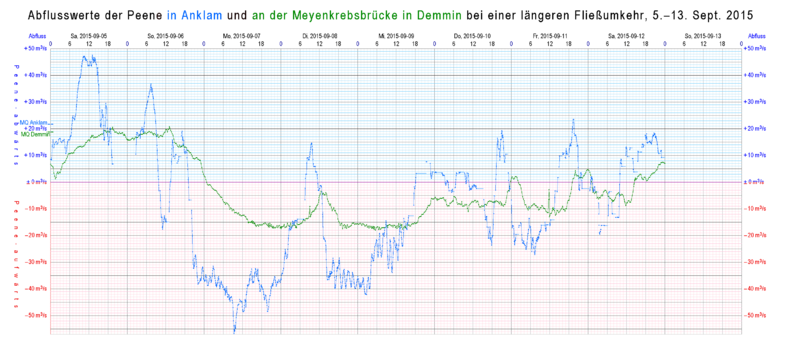 Flows in
Anklam
and in
Demmin
during the same week. The lower part of this graphic (with red grid )shows reverse flows.
Flows in
Anklam
and in
Demmin
during the same week. The lower part of this graphic (with red grid )shows reverse flows.
Ecology
[
edit
]
The
Peene Valley
is one of the largest contiguous
fen
regions in central Europe.
[1]
Thanks to its wilderness and intact nature, the river Peene and its valley is sometimes grandiloquently referred to as "the
Amazon
of the North".
[2]
Major towns at the Peene river are
Malchin
,
Teterow
,
Demmin
and
Anklam
.
Wolgast
is on
Peenestrom
strait.
References
[
edit
]
External links
[
edit
]
|
|---|
| Regions
| |
|---|
| Administration
| |
|---|
| Cities and towns
| |
|---|
| Inhabited islands
| |
|---|
| Peninsulae and
headlands
| |
|---|
| Rivers
| |
|---|
| Lakes
| |
|---|
| Bays, lagoons
| |
|---|
| National parks
| |
|---|
|
|---|
|
|
|
|
|---|
| Archaeological cultures
| |
|---|
| Peoples
| |
|---|
| Major demographic events
| |
|---|
| Languages and dialects
| |
|---|
|
|
Treaties
|
|---|
| 1200–1500
| |
|---|
| 1500–1700
| |
|---|
| 1700–present
| |
|---|
|
|
