原始文件
(1,000 × 677像素,文件大小:98 KB,MIME?型:
image/png
)
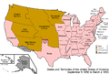
| Territorial evolution maps of the United States
|
| v
·
d
(template shows date of beginning of change yyyy-mm-dd)
|
| 1789-03
,
1789-08
,
1790-04
,
1790-05
,
1791-03
,
1791-09
,
1792-03
,
1792-06
,
1795
,
1796
,
1798
,
1800-07-04
,
1800-07
,
1802
,
1803-03
,
1803-04
,
1804-03
,
1804-10
,
1805-01
,
1805-07
,
1809
,
1810-04
,
1810-10
,
1812-04
,
1812-05
,
1812-06
,
1816
,
1817-03
,
1817-12
,
1818-10
,
1818-12
,
1819-03
,
1819-12
,
1820
,
1821-07
,
1821
,
1822
,
1824
,
1828
,
1834
,
1836-03
,
1836-06
,
1836-07
,
1837-01
,
1837-03
,
1838
,
1842
,
1845-03
,
1845-12
,
1846-06
,
1846-12
,
1848-02
,
1848-05
,
1848-08
,
1849
,
1850
,
1853-03
,
1853-12
,
1854
,
1858
,
1859
,
1860
,
1861-01
,
1861-02-04
,
1861-02-28
,
1861-03
,
1861-08
,
1862
,
1863-02
,
1863-03
,
1863-06
,
1864-05
,
1864-10
,
1865
,
1866
,
1867-01
,
1867-03
,
1867-10
,
1868
,
1876
,
1884
,
1889-11-02
,
1889-11-08
,
1889-11-11
,
1890-05
,
1890-07-03
,
1890-07-10
,
1896-01
,
1896-05
,
1898
,
1907
,
1912-01
,
1912-02
,
1912-08
,
1959-01
,
1959-08
|
文件?史
点?某?日期/???看???刻的文件。
| 日期/??
| ??略??
| 大小
| 用?
| ?注
|
|---|
| ?前
| 2006年7月29日 (六) 07:04
|  | 1,000 × 677
(98 KB)
| Golbez
| {{Information| |Description=Map of the states and territories of the United States as it was from |Source= |Date= |Author=Made by
User:Golbez
. |Permission=Own work, attribution required (Multi-license with GFDL and Creative Commons CC-BY 2.5) |other_
|
文件用途
全域文件用途
以下其他wiki使用此文件:
- ar.wikipedia.org上的用途
- ca.wikipedia.org上的用途
- da.wikipedia.org上的用途
- de.wikipedia.org上的用途
- en.wikipedia.org上的用途
- es.wikipedia.org上的用途
- fo.wikipedia.org上的用途
- fr.wikipedia.org上的用途
- he.wikipedia.org上的用途
- it.wikipedia.org上的用途
- ja.wikipedia.org上的用途
- nl.wikipedia.org上的用途
- no.wikipedia.org上的用途
- ru.wikipedia.org上的用途
- sv.wikipedia.org上的用途
- vi.wikipedia.org上的用途
