| 日期/??
| ??略??
| 大小
| 用?
| ?注
|
|---|
| ?前
| 2014年6月5日 (四) 05:30
|  | 1,000 × 677
(245 KB)
| RedXIV
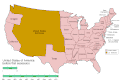
| Removed incorrect information. Kentucky and Missouri never seceded. The state governments of Kentucky and Missouri never voted to secede. Claiming that their secession actually happened gives an inaccurate impression of the actual sequence of events.
|
| 2013年12月21日 (六) 10:56
|  | 1,000 × 677
(256 KB)
| ChrisnHouston
| I'm the one who broke the thumbnail. I'll try to fix it now...
|
| 2013年12月20日 (五) 13:38
|  | 1,000 × 677
(1.75 MB)
| Afernand74
| No image displayed. Reupload to try to solve the problem
|
| 2013年11月7日 (四) 11:33
|  | 1,000 × 677
(1.75 MB)
| ChrisnHouston
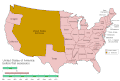
| Adding a bar to the timeline to indicate when the actual fighting of the Civil War happened, which is one of the most important aspects of this map.
|
| 2012年4月11日 (三) 15:18
|  | 1,000 × 677
(254 KB)
| Golbez
| rv - er, MO and KY were indeed admitted to the CSA, though it lacked any control over them. why not go to the talk page for the CSA on enwp and chat about my next version?
|
| 2012年4月10日 (二) 18:53
|  | 1,000 × 677
(225 KB)
| Travursa
| Fixed errors.
|
| 2007年11月18日 (日) 01:57
|  | 1,000 × 677
(254 KB)
| Golbez
| Removing frame of WV counties; that was incorrect, they were always part of WV
|
| 2007年3月4日 (日) 09:54
|  | 1,000 × 677
(259 KB)
| Golbez
| == Summary == {{Information |Description=Animated map/timeline of the territorial evolution of the Confederate States of America, from first secession to end of Reconstruction. |Source=Self-made. |Date=March 2007 |Author=
User:Golbez
|Permission= see b
|