The
history of cartography
refers to the development and consequences of
cartography
, or mapmaking technology, throughout human history. Maps have been one of the most important human inventions for millennia, allowing humans to explain and navigate their way through the world.
When and how the earliest maps were made is unclear, but maps of local terrain are believed to have been independently invented by many cultures. The earliest surviving maps include
cave paintings
and etchings on tusk and stone. Maps were produced extensively by ancient
Babylon
, Greece, Rome, China, and India.
The earliest maps ignored the curvature of Earth's surface, both because the shape of the Earth was uncertain and because the curvature is not important across the small areas being mapped. However, since the age of
Classical Greece
, maps of large regions, and especially of the world, have used
projection
from a model globe to control how the inevitable distortion gets apportioned on the map.
Modern methods of transportation, the use of
surveillance aircraft
, and more recently the availability of
satellite imagery
have made documentation of many areas possible that were previously inaccessible. Free online services such as
Google Earth
have made accurate maps of the world more accessible than ever before.
Etymology
[
edit
]
The English term
cartography
is modern, borrowed from the French
cartographie
in the 1840s, itself based on
Middle Latin
carta
"map".
Pre-modern era
[
edit
]
Earliest known maps
[
edit
]
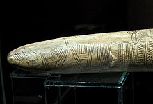 Possibly the oldest surviving map has been engraved on this mammoth tusk, dated to 25,000 BC, found from Pavlov in the
Czech Republic
.
Possibly the oldest surviving map has been engraved on this mammoth tusk, dated to 25,000 BC, found from Pavlov in the
Czech Republic
.
It is not always clear whether an ancient artifact had been wrought as a map or as something else. The definition of "map" is also not precise. Thus, no single artifact is generally accepted to be the earliest surviving map. Candidates include:
- A map-like representation of a mountain, river, valleys and routes around Pavlov in the
Czech Republic
, carved on a mammoth tusk, that has been dated to 25,000 BC.
[1]
- An
Aboriginal Australian
cylcon
that may be as much as 20,000 years old that is thought to depict the
Darling River
.
[2]
- A map etched on a mammoth bone at
Mezhyrich
that is about 15,000 years old.
- Dots dating to 14,500 BC found on the walls of the
Lascaux
caves map of part of the night sky, including the three bright stars
Vega
,
Deneb
, and
Altair
(the
Summer Triangle
asterism), as well as the
Pleiades
star cluster. The
Cuevas de El Castillo
in Spain that contains a dot map of the
Corona Borealis
constellation dating from 12,000 BC.
[3]
[4]
[5]
- A polished chunk of
sandstone
from a cave in Spanish
Navarre
, dated to 14,000 BC, that may be symbols for landscape features, such as hills or dwellings,
[6]
superimposed on animal etchings. Alternatively, it may also represent a spiritual landscape, or simple incisings.
[7]
[8]
- Another ancient picture that resembles a map that was created in the late 7th millennium BC in
Catalhoyuk
,
Anatolia
, modern
Turkey
. This wall painting may represent a plan of this Neolithic village;
[9]
however, recent scholarship has questioned the identification of this painting as a map.
[10]
- The "Saint-Belec slab" (2200?1600 BC), whose lines and symbols have been argued to represent a cadastral plan of a part of western Brittany.
[11]
Ancient Near East
[
edit
]
 Clay tablet with map of the Babylonian city of Nippur (
c.
1400 BC
)
Clay tablet with map of the Babylonian city of Nippur (
c.
1400 BC
)
Maps in Ancient
Babylonia
were made by using accurate
surveying
techniques.
[12]
For example, a 7.6 × 6.8 cm
clay tablet
found in 1930 at
Ga-Sur
, near contemporary
Kirkuk
, shows a map of a river valley between two hills.
Cuneiform
inscriptions label the features on the map, including a plot of land described as 354 iku (12 hectares) that was owned by a person called Azala. Most scholars date the tablet to the 25th to 24th century BC. Hills are shown by overlapping semicircles, rivers by lines, and cities by circles. The map also is marked to show the
cardinal directions
.
[13]
An engraved map from the Kassite period (14th?12th centuries BC) of Babylonian history shows walls and buildings in the holy city of
Nippur
.
[14]
The
Babylonian World Map
, the earliest surviving map of the world (
c.
600
BC), is a symbolic, not a literal representation. It deliberately omits peoples such as the
Persians
and
Egyptians
, who were well known to the Babylonians. The area shown is depicted as a circular shape surrounded by water, which fits the religious image of the world in which the Babylonians believed.
Phoenician
sailors made major advances in seafaring and exploration. It is recorded that the first
circumnavigation
of Africa was possibly undertaken by Phoenician explorers employed by Egyptian
pharaoh
Necho II
c. 610?595 BC.
[15]
[16]
In
The Histories
, written 431?425 BC,
Herodotus
cast doubt on a report of the Sun observed shining from the north. He stated that the phenomenon was observed by Phoenician explorers during their circumnavigation of Africa (
The Histories
, 4.42) who claimed to have had the Sun on their right when circumnavigating in a clockwise direction. To modern historians, these details confirm the truth of the Phoenicians' report, and even suggest the possibility that the Phoenicians knew about the
spherical Earth
model. However, nothing certain about their knowledge of geography and navigation has survived.
[15]
The historian Dmitri Panchenko theorizes that it was the Phoenician circumnavigation of Africa that inspired the theory of a spherical Earth by the 5th century BC.
[16]
Ancient Greece
[
edit
]
Many scholars throughout history, such as
Strabo
, Kish, and
Dilke
, consider
Homer
to be the founder of the early Greek conception of Earth, and therefore of geography.
Homer
conceived Earth to be a disk surrounded by a constantly moving
stream of Ocean
,
[17]
: 22
an idea which would be suggested by the appearance of the horizon as it is seen from a mountaintop or from a seacoast. This model was accepted by the early
Greeks
. Homer and his Greek contemporaries knew very little of the Earth beyond the Libyan desert of
Egypt
, the southwest coast of
Asia Minor
, and the northern boundary of the Greek homeland. Furthermore, the coast of the Black Sea was only known through myths and legends that circulated during his time. In his poems there is no mention of Europe and Asia as geographical concepts.
[18]
[
full citation needed
]
That is why the big part of Homer's world that is portrayed on this interpretive map represents lands that border on the
Aegean Sea
. The Greeks believed that they occupied the central region of Earth and its edges were inhabited by savage, monstrous
barbarians
and strange animals and monsters: Homer's Odyssey mentions a great many of these.
Additional statements about ancient geography are found in
Hesiod
's poems, probably written during the 8th century BC.
[19]
Through the lyrics of
Works and Days
and
Theogony
, he shows to his contemporaries some definite geographical knowledge. He introduces the names of such rivers as
Nile
,
Ister
(
Danube
), the shores of the
Bosporus
and the
Euxine
(
Black Sea
), the coast of
Gaul
, the island of
Sicily
, and a few other regions and rivers.
[20]
His advanced geographical knowledge not only had predated Greek colonial expansions, but also was used in the earliest Greek world maps, produced by Greek mapmakers such as
Anaximander
and
Hecataeus of Miletus
, and
Ptolemy
using both observations by explorers and a mathematical approach.
Early steps in the development of intellectual thought in
ancient Greece
belonged to
Ionians
from their well-known city of
Miletus
in
Asia Minor
. Miletus was placed favourably to absorb aspects of
Babylonian
knowledge and to profit from the expanding commerce of the
Mediterranean
. The earliest ancient Greek who is said to have constructed a map of the world is Anaximander of Miletus (
c.
611?546 BC
), pupil of
Thales
. He believed that the Earth was a cylindrical form, a stone pillar suspended in space.
[21]
The inhabited part of his world was circular, disk-shaped, and presumably located on the upper surface of the cylinder.
[17]
: 24
For constructing his world map, Anaximander is considered by many to be the first mapmaker.
[22]
: 23
Little is known about the map, which has not survived.
Hecataeus of Miletus
(550?475 BC) produced another map fifty years later that he claimed was an improved version of the map of his illustrious predecessor.
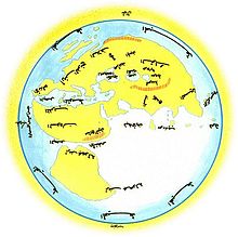
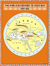 The world according to
Hekatæus
, 500 BC
The world according to
Hekatæus
, 500 BC
Hecatæus's map describes the Earth as disk with an encircling Ocean, and with Greece placed in the center. This was a very popular contemporary Greek worldview, derived originally from the Homeric poems. Also, similar to many other early maps in antiquity, his map has no scale. As units of measurements, this map used "days of sailing" on the sea and "days of marching" on dry land.
[23]
The purpose of this map was to accompany Hecatæus's geographical work that was called
Periodos Ges
, or
Journey Round the World
.
[22]
: 24
Periodos Ges
was divided into two books, "Europe" and "Asia", with the latter including Libya, the name of which was an ancient term for all of known Africa.
The work divides the world into two continents, Asia and Europe. Hecatæus depicts the line between the Pillars of Hercules through the Bosporus, and the Don River as a boundary between the two. He was the first writer known to have thought that the Caspian flows into the encircling ocean?an idea that persisted long into the Hellenic period. He was particularly instructive about the Black Sea, adding many geographic places that already were known to Greeks through the colonization process. To the north of the Danube, according to Hecatæus, were the
Rhipæan
(gusty) Mountains, beyond which lived the
Hyperboreans
?peoples of the far north. Hecatæus depicted the origin of the Nile River at the southern encircling ocean. His view of the Nile seems to have been that it came from the southern encircling ocean. This assumption helped Hecatæus propose a solution to the mystery of the annual flooding of the Nile. He believed that the waves of the ocean were a primary cause of this occurrence.
[24]
A map based on Hecataeus's was intended to aid political decision-making. According to
Herodotus
, that map was engraved into a bronze tablet and was carried to Sparta by Aristagoras during the revolt of the Ionian cities against
Persian
rule from 499 to 494 BC.
 The world according to
Anaximenes
,
c.
500
BC
The world according to
Anaximenes
,
c.
500
BC
Anaximenes
of Miletus (6th century BC), who studied under Anaximander, rejected the views of his teacher regarding the shape of the Earth and instead, he visualized the Earth as a rectangular form supported by compressed air.
Pythagoras of Samos
(
c.
560
?480 BC) speculated about the notion of a spherical Earth with a central fire at its core. He is sometimes incorrectly credited with the introduction of a model that divides a spherical Earth into five zones: one hot, two temperate, and two cold?northern and southern. This idea, known as the zonal theory of climate, is more likely to have originated at the time of
Aristotle
.
[25]
Scylax
, a sailor, made a record of his
Mediterranean
voyages in
c.
515
BC. This is the earliest known set of Greek
periploi
, or sailing instructions, which became the basis for many future mapmakers, especially in the medieval period.
[26]
The way in which the geographical knowledge of the Greeks advanced from the previous assumptions of the Earth's shape was through Herodotus and his conceptual view of the world. This map also did not survive and many have speculated that it was never produced. A possible reconstruction of his map is displayed below.
 The world according to
Herodotus
, 440 BC
The world according to
Herodotus
, 440 BC
Herodotus traveled extensively, collecting information and documenting his findings in his books on Europe, Asia, and Libya. He also combined his knowledge with what he learned from the people he met. Herodotus wrote his
Histories
in the mid-5th century BC. Although his work was dedicated to the story of long struggle of the Greeks with the Persian Empire, Herodotus also included everything he knew about the geography, history, and peoples of the world. Thus, his work provides a detailed picture of the known world of the 5th century BC.
Herodotus rejected the prevailing view of most 5th-century BC maps that the Earth is a disk surrounded by ocean. In his work he describes the Earth as an irregular shape with oceans surrounding only Asia and Africa. He introduces names such as the Atlantic Sea, and the
Erythrean Sea
, which translates as the "Red Sea". He also divided the world into three continents: Europe, Asia, and Africa. He depicted the boundary of Europe as the line from the
Pillars of Hercules
through the
Bosphorus
and the area between the
Caspian Sea
and the
Indus River
. He regarded the
Nile
as the boundary between Asia and Africa. He speculated that the extent of Europe was much greater than was assumed at the time and left Europe's shape to be determined by future research.
In the case of Africa, he believed that, except for the small stretch of land in the vicinity of Suez, the continent was in fact surrounded by water. However, he definitely disagreed with his predecessors and contemporaries about its presumed circular shape. He based his theory on the story of Pharaoh
Necho II
, the ruler of Egypt between 609 and 594 BC, who had sent
Phoenicians
to circumnavigate Africa. Apparently, it took them three years, but they certainly did prove his idea. He speculated that the Nile River started as far west as the
Ister River
(Danube) in Europe and cut Africa through the middle. He was the first writer to assume that the Caspian Sea was separated from other seas and he recognised northern Scythia as one of the coldest inhabited lands in the world.
Similar to his predecessors, Herodotus also made mistakes. He accepted a clear distinction between the civilized Greeks in the center of the Earth and the barbarians on the world's edges. In his
Histories
it is clear that he believed that the world became stranger and stranger when one traveled away from Greece, until one reached the ends of the Earth, where humans behaved as savages.
While various previous Greek philosophers presumed the Earth to be spherical,
Aristotle
(384?322 BC) is credited with proving the Earth's sphericity. His arguments may be summarized as follows:
- The
lunar eclipse
is always circular
- Ships seem to sink as they move away from view and pass the horizon
- Some stars can be seen only from certain parts of the Earth.
Hellenistic Mediterranean
[
edit
]
A vital contribution to mapping the reality of the world came with a scientific estimate of the circumference of the earth. This event has been described as the first scientific attempt to give geographical studies a mathematical basis. The man credited for this achievement was
Eratosthenes
(275?195 BC), a Greek scholar who lived in
Hellenistic
North Africa. As described by
George Sarton
, historian of science, "there was among them [Eratosthenes's contemporaries] a man of genius but as he was working in a new field they were too stupid to recognize him".
[27]
His work, including
On the Measurement of the Earth
and
Geographica
, has only survived in the writings of later philosophers such as
Cleomedes
and
Strabo
. He was a devoted geographer who set out to reform and perfect the map of the world. Eratosthenes argued that accurate mapping, even if in two dimensions only, depends upon the establishment of accurate linear measurements. He was the first to calculate the
Earth's circumference
(within 0.5 percent accuracy).
[28]
His great achievement in the field of cartography was the use of a new technique of charting with
meridians
, his imaginary north?south lines, and
parallels
, his imaginary west?east lines.
[29]
These axis lines were placed over the map of the Earth with their origin in the city of Rhodes and divided the world into sectors. Then, Eratosthenes used these earth partitions to reference places on the map. He also divided Earth into five climatic regions which was proposed at least as early as the late sixth or early fifth century BC by
Parmenides
: a torrid zone across the middle, two frigid zones at extreme north and south, and two temperate bands in between.
[30]
He was likely also the first person to use the word "geography".
[31]
Roman Empire
[
edit
]
Pomponius Mela
[
edit
]
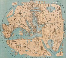 Reconstruction of
Pomponius Mela
's world map.
Reconstruction of
Pomponius Mela
's world map.
Pomponius Mela
is unique among ancient geographers in that, after dividing the earth into five zones, of which two only were habitable, he asserts the existence of
antichthones
, inhabiting the southern temperate zone inaccessible to the folk of the northern temperate regions from the unbearable heat of the intervening torrid belt. On the divisions and boundaries of Europe, Asia and Africa, he repeats Eratosthenes; like all classical geographers from
Alexander the Great
(except
Ptolemy
) he regards the
Caspian Sea
as an inlet of the Northern Ocean, corresponding to the
Persian Gulf
and the
Red Sea
on the south.
Marinus of Tyre
[
edit
]
Marinus of Tyre
was a
Hellenized
Phoenician
geographer and cartographer.
[32]
He founded mathematical geography and provided the underpinnings of
Ptolemy
's influential
Geographia
.
Marinus's geographical treatise is lost and known only from Ptolemy's remarks. He introduced improvements to the construction of maps and developed a system of nautical charts. His chief legacy is that he first assigned to each place a proper
latitude
and
longitude
. His
zero meridian
ran through the westernmost land known to him, the
Isles of the Blessed
around the location of the
Canary
or
Cape Verde Islands
. He used the parallel of
Rhodes
for measurements of latitude. Ptolemy mentions several revisions of Marinus's geographical work, which is often dated to AD 114 although this is uncertain. Marinus estimated a length of 180,000
stadia
for the equator, roughly corresponding
[a]
to a circumference of the Earth of 33,300 km, about 17% less than the actual value.
He also carefully studied the works of his predecessors and the diaries of travelers. His maps were the first in the
Roman Empire
to show China. He also invented
equirectangular projection
, which is still used in map creation today. A few of Marinus's opinions are reported by Ptolemy. Marinus was of the opinion that the
World Ocean
was separated into an eastern and a western part by the continents of Europe, Asia and Africa. He thought that the inhabited world stretched in latitude from
Thule
(
Norway
) to
Agisymba
(around the
Tropic of Capricorn
) and in longitude from the
Isles of the Blessed
(around the
Canaries
) to Shera (China). Marinus also coined the term
Antarctic
, referring to the opposite of the
Arctic Circle
.
Ptolemy
[
edit
]
Ptolemy
(90?168), a Hellenized
Egyptian
,
[33]
[34]
[35]
thought that, with the aid of astronomy and mathematics, the Earth could be mapped very accurately. Ptolemy revolutionized the depiction of the spherical Earth on a map by using
perspective projection
, and suggested precise methods for fixing the position of geographic features on its surface using a
coordinate system
with parallels of
latitude
and
meridians
of
longitude
.
[6]
[36]
Ptolemy's eight-volume atlas
Geographia
is a prototype of modern mapping and
GIS
. It included an index of place-names, with the latitude and longitude of each place to guide the search, scale, conventional signs with legends, and the practice of orienting maps so that north is at the top and east to the right of the map?an almost universal custom today.
Yet with all his important innovations, however, Ptolemy was not infallible. His most important error was a miscalculation of the circumference of the Earth. He believed that
Eurasia
covered 180° of the globe, which convinced
Christopher Columbus
to sail across the Atlantic to look for a simpler and faster way to travel to India. Had Columbus known that the true figure was much greater, it is conceivable that he would never have set out on his momentous voyage.
Tabula Peutingeriana
[
edit
]
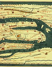 Modern version of the Roman
Tabula Peutingeriana
(5th century).
Modern version of the Roman
Tabula Peutingeriana
(5th century).
In 2007, the
Tabula Peutingeriana
, a 12th-century replica of a 5th-century road map, was placed on the UNESCO Memory of the World Register and displayed to the public for the first time. Although the scroll is well preserved and believed to be an accurate copy of an authentic original, it is on media that is now so delicate that it must be protected at all times from exposure to daylight.
[37]
China
[
edit
]
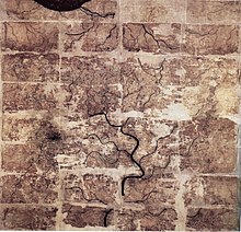
The earliest known maps to have survived in China date to the 4th century BC.
[38]
: 90
In 1986, seven ancient Chinese maps were found in an archeological excavation of a
Qin State
tomb in what is now
Fangmatan
, in the vicinity of Tianshui City,
Gansu
.
[38]
: 90
Before this find, the earliest extant maps that were known came from the
Mawangdui Han tomb
excavation in 1973, which found three maps on silk dated to the 2nd century BC in the early
Han dynasty
.
[38]
: 90, 93
The 4th-century BC maps from the State of Qin were drawn with black ink on wooden blocks.
[38]
: 91
These blocks fortunately survived in soaking conditions due to underground water that had seeped into the tomb; the quality of the wood had much to do with their survival.
[38]
: 91
After two years of slow-drying techniques, the maps were fully restored.
[38]
: 91
The territory shown in the seven Qin maps overlap each other.
[38]
: 92
The maps display tributary river systems of the
Jialing River
in Sichuan, in a total measured area of 107 by 68 km.
[38]
: 92
The maps featured rectangular symbols encasing character names for the locations of administrative counties.
[38]
: 92
Rivers and roads are displayed with similar line symbols; this makes interpreting the map somewhat difficult, although the labels of rivers placed in order of stream flow are helpful to modern day cartographers.
[38]
: 92?93
These maps also feature locations where different types of timber can be gathered, while two of the maps state the
distances in mileage
to the timber sites.
[38]
: 93
In light of this, these maps are perhaps the oldest
economic maps
in the world since they predate
Strabo
's economic maps.
[38]
: 93
In addition to the seven maps on wooden blocks found at Tomb 1 of Fangmatan, a fragment of a paper map was found on the chest of the occupant of Tomb 5 of Fangmatan in 1986. This tomb is dated to the early
Western Han
, so the map dates to the early 2nd century BC. The map shows topographic features such as mountains, waterways and roads, and is thought to cover the area of the preceding
Qin Kingdom
.
[39]
[40]
Earliest geographical writing
[
edit
]
In China, the earliest known geographical Chinese writing dates back to the 5th century BC, during the beginning of the
Warring States
(481?221 BC).
[41]
: 500
This was the
Yu Gong
or
Tribute of Yu
chapter of the
Shu Jing
or
Book of Documents
. The book describes the traditional nine provinces, their kinds of soil, their characteristic products and economic goods, their tributary goods, their trades and vocations, their state revenues and agricultural systems, and the various rivers and lakes listed and placed accordingly.
[41]
: 500
The nine provinces in the time of this geographical work were very small in size compared to their modern Chinese counterparts. The Yu Gong's descriptions pertain to areas of the
Yellow River
, the lower valleys of the
Yangzi
, with the plain between them and the
Shandong Peninsula
, and to the west the most northern parts of the
Wei River
and the
Han River
were known (along with the southern parts of modern-day
Shanxi
).
[41]
: 500
Earliest known reference to a map (圖 tu)
[
edit
]
The oldest reference to a map in China comes from the 3rd century BC.
[41]
: 534
This was the event of 227 BC where
Crown Prince Dan of Yan
had his assassin
Jing Ke
visit the court of the ruler of the
State of Qin
, who would become the first leader to unify China,
Qin Shi Huang
(r. 221?210 BC). Jing Ke was to present the ruler of Qin with a district map painted on a silk scroll, rolled up and held in a case where he hid his assassin's dagger.
[41]
: 534
Handing to him the map of the designated territory was the first diplomatic act of submitting that district to Qin rule.
[41]
: 534
Jing then tried and failed to kill him. From then on, maps were frequently mentioned in Chinese sources.
[41]
: 535
Han dynasty
[
edit
]
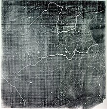
 An early
Western Han dynasty
(202 BC ? 9 AD) silk map found in tomb 3 of
Mawangdui Han tombs site
, depicting the Kingdom of
Changsha
and Kingdom of
Nanyue
in southern China (note: the south direction is oriented at the top, north at the bottom).
An early
Western Han dynasty
(202 BC ? 9 AD) silk map found in tomb 3 of
Mawangdui Han tombs site
, depicting the Kingdom of
Changsha
and Kingdom of
Nanyue
in southern China (note: the south direction is oriented at the top, north at the bottom).
The three Han dynasty maps found at
Mawangdui
differ from the earlier Qin State maps. While the Qin maps place the
cardinal direction
of north at the top of the map, the Han maps are orientated with the southern direction at the top.
[38]
: 93
The Han maps are also more complex, since they cover a much larger area, employ a large number of well-designed map symbols, and include additional information on local military sites and the local population.
[38]
: 93
The Han maps also note measured distances between certain places, but a formal
graduated scale and rectangular grid system
for maps would not be used?or at least described in full?until the 3rd century (see
Pei Xiu
below).
[38]
: 93?94
Among the three maps found at Mawangdui was a small map representing the tomb area where it was found, a larger topographical map showing the Han's borders along the subordinate
Kingdom of Changsha
and the
Nanyue
kingdom (of northern
Vietnam
and parts of modern
Guangdong
and
Guangxi
), and a map which marks the positions of Han military garrisons that were employed in an
attack against Nanyue
in 181 BC.
[42]
An early text that mentioned maps was the
Rites of Zhou
.
[41]
: 534
Although attributed to the era of the
Zhou dynasty
, its first recorded appearance was in the libraries of Prince Liu De (
c.
130
BC), and was compiled and commented on by
Liu Xin
in the 1st century AD. It outlined the use of maps that were made for governmental provinces and districts, principalities, frontier boundaries, and even pinpointed locations of ores and minerals for mining facilities.
[41]
: 534
Upon the investiture of three of his sons as feudal princes in 117 BC,
Emperor Wu of Han
had maps of the entire empire submitted to him.
[41]
: 536
From the 1st century AD onwards, official Chinese historical texts contained a geographical section (地理?;
Diliji
), which was often an enormous compilation of changes in place-names and local administrative divisions controlled by the ruling dynasty, descriptions of mountain ranges, river systems, taxable products, etc.
[41]
: 508
From the 5th century BC
Shu Jing
forward, Chinese geographical writing provided more concrete information and less legendary element. This example can be seen in the 4th chapter of the
Huainanzi
(Book of the Master of Huainan), compiled under the editorship of Prince
Liu An
in 139 BC during the
Han dynasty
(202 BC?202 AD). The chapter gave general descriptions of
topography
in a systematic fashion, given visual aids by the use of maps (di tu) due to the efforts of Liu An and his associate Zuo Wu.
[41]
: 507?508
In
Chang Chu
's
Hua Yang Guo Chi
("Historical Geography of
Sichuan
") of 347, not only rivers, trade routes, and various tribes were described, but it also wrote of a 'Ba June Tu Jing' ("Map of Sichuan"), which had been made much earlier in 150.
[41]
: 517
Local mapmaking such as the one of
Sichuan
mentioned above, became a widespread tradition of Chinese geographical works by the 6th century, as noted in the bibliography of the
Sui Shu
.
[41]
: 518
It is during this time of the
Southern and Northern Dynasties
that the
Liang dynasty
(502?557) cartographers also began carving maps into stone steles (alongside the maps already drawn and painted on paper and silk).
[41]
: 543
Pei Xiu, the 'Ptolemy of China'
[
edit
]
In the year 267,
Pei Xiu
(224?271) was appointed as the Minister of Works by
Emperor Wu of Jin
, the first emperor of the
Jin dynasty
. Pei is best known for his work in cartography. Although map making and use of the grid existed in China before him,
[41]
: 106?107
he was the first to mention a
plotted geometrical grid and graduated scale
displayed on the surface of maps to gain greater accuracy in the estimated distance between different locations.
[41]
: 538?540
Pei outlined six principles that should be observed when creating maps, two of which included the rectangular grid and the graduated scale for measuring distance.
[41]
: 539?540
Western historians compare him to the Greek Ptolemy for his contributions in cartography.
[41]
: 540
However, Howard Nelson states that, although the accounts of earlier cartographic works by the inventor and official
Zhang Heng
(78?139) are somewhat vague and sketchy, there is ample written evidence that Pei Xiu derived the use of the rectangular grid reference from the maps of Zhang Heng.
[43]
: 359
Later Chinese ideas about the quality of maps made during the Han dynasty and before stem from the assessment given by Pei Xiu.
[38]
: 96
Pei Xiu noted that the extant Han maps at his disposal were of little use since they featured too many inaccuracies and exaggerations in measured distance between locations.
[38]
: 96
However, the Qin State maps and
Mawangdui
maps of the Han era were far superior in quality than those examined by Pei Xiu.
[38]
: 96
It was not until the 20th century that Pei Xiu's 3rd-century assessment of earlier maps' dismal quality would be overturned and disproven. The Qin and Han maps did have a degree of accuracy in scale and pinpointed location, but the major improvement in Pei Xiu's work and that of his contemporaries was expressing topographical elevation on maps.
[38]
: 97
Sui dynasty
[
edit
]
In the year 605, during the
Sui dynasty
(581?618), the Commercial Commissioner
Pei Ju
(547?627) created a famous geometrically gridded map.
[41]
: 543
In 610
Emperor Yang of Sui
ordered government officials from throughout the empire to document in
gazetteers
the customs, products, and geographical features of their local areas and provinces, providing descriptive writing and drawing them all onto separate maps, which would be sent to the imperial secretariat in the capital city.
[41]
: 518
[44]
: 409?10
Tang dynasty
[
edit
]
The
Tang dynasty
(618?907) also had its fair share of cartographers, including the works of
Xu Jingzong
in 658,
Wang Mingyuan
in 661, and
Wang Zhongsi
in 747.
[41]
: 543
Arguably the greatest geographer and cartographer of the Tang period was
Jia Dan
(730?805), whom
Emperor Dezong of Tang
entrusted in 785 to complete a map of China with her recently former inland colonies of Central Asia, the massive and detailed work completed in 801, called the
Hai Nei Hua Yi Tu
(Map of both Chinese and Barbarian Peoples within the (Four) Seas).
[41]
: 543
The map was 30 ft long (9.1 m) and 33 ft high (10 m) in dimension, mapped out on a grid scale of 1-inch (25 mm) equaling 100
li (unit)
(the Chinese equivalent of the mile/kilometer).
[41]
: 543
Jia Dan is also known for having described the
Persian Gulf
region with great detail, along with lighthouses that were erected at the mouth of the Persian Gulf by the medieval Iranians in the
Abbasid
period (refer to article on
Tang dynasty
for more).
Song dynasty
[
edit
]
 The
Yu Ji Tu
, or
Map of the Tracks of Yu Gong
, carved into stone in 1137,
[45]
located in the
Stele Forest
of
Xi'an
. This 3 ft (0.91 m) squared map features a graduated scale of 100
li
for each rectangular grid. China's coastline and river systems are clearly defined and precisely pinpointed on the map.
Yu Gong
is in reference to the Chinese deity described in the
geographical chapter
of the
Classic of History
, dated 5th century BC.
The
Yu Ji Tu
, or
Map of the Tracks of Yu Gong
, carved into stone in 1137,
[45]
located in the
Stele Forest
of
Xi'an
. This 3 ft (0.91 m) squared map features a graduated scale of 100
li
for each rectangular grid. China's coastline and river systems are clearly defined and precisely pinpointed on the map.
Yu Gong
is in reference to the Chinese deity described in the
geographical chapter
of the
Classic of History
, dated 5th century BC.
During the
Song dynasty
(960?1279)
Emperor Taizu of Song
ordered
Lu Duosun
in 971 to update and 're-write all the Tu Jing in the world', which would seem to be a daunting task for one individual, who was sent out throughout the provinces to collect texts and as much data as possible.
[41]
: 518
With the aid of
Song Zhun
, the massive work was completed in 1010, with some 1566 chapters.
[41]
: 518
The later
Song Shi
historical text stated (
Wade-Giles
spelling):
Yuan Hsieh (d. +1220) was director-general of governmental grain stores. In pursuance of his schemes for the relief of famines he issued orders that each pao (village) should prepare a map which would show the fields and mountains, the rivers and the roads in fullest detail. The maps of all the pao were joined together to make a map of the tu (larger district), and these in turn were joined with others to make a map of the hsiang and the hsien (still larger districts). If there was any trouble about the collection of taxes or the distribution of grain, or if the question of chasing robbers and bandits arose, the provincial officials could readily carry out their duties by the aid of the maps.
[41]
: 518
Like the earlier Liang dynasty stone-stele maps (mentioned above), there were large and intricately carved stone stele maps of the Song period. For example, the 3 ft (0.91 m) squared stone stele map of an anonymous artist in 1137, following the grid scale of 100 li squared for each grid square.
[41]
: Plate LXXXI
What is truly remarkable about this map is the incredibly precise detail of coastal outlines and river systems in China (refer to Needham's Volume 3, Plate LXXXI for an image). The map shows 500 settlements and a dozen rivers in China, and extends as far as Korea and India. On the reverse, a copy of a more ancient map uses grid coordinates in a scale of 1:1,500,000 and shows the coastline of China with great accuracy.
[46]
The famous 11th-century scientist and
polymath
statesman
Shen Kuo
(1031?1095) was also a geographer and cartographer.
[41]
: 541
His largest
atlas
included twenty three maps of China and foreign regions that were drawn at a uniform scale of 1:900,000.
[47]
Shen also created a
three-dimensional
raised-relief map
using sawdust, wood, beeswax, and wheat paste, while representing the topography and specific locations of a frontier region to the imperial court.
[47]
Shen Kuo's contemporary,
Su Song
(1020?1101), was a cartographer who created detailed maps to resolve a territorial border dispute between the Song dynasty and the
Liao dynasty
.
[48]
Yuan dynasty (Mongol Empire)
[
edit
]
In the
Mongol Empire
, the
Mongol
scholars with the Persian and Chinese cartographers or their foreign colleagues created maps, geographical compendium as well as travel accounts.
Rashid-al-Din Hamadani
described his geographical compendium, "Suvar al-aqalim", constituted volume four of the Collected chronicles of the
Ilkhanate
in Persia.
[49]
His works says about the borders of the seven climes (old world), rivers, major cities, places, climate, and
Mongol yams (relay stations)
. The
Great Khan
Khubilai
's ambassador and minister,
Bolad
, had helped Rashid's works in relation to the Mongols and
Mongolia
.
[50]
Thanks to
Pax Mongolica
, the easterners and the westerners in Mongol dominions were able to gain access to one another's geographical materials.
[51]
The Mongols required the nations they conquered to send geographical maps to the Mongol headquarters.
[52]
[53]
One of medieval Persian work written in northwest Iran can clarify the historical geography of
Mongolia
where
Genghis Khan
was born and united the Mongol and
Turkic
nomads
as recorded in native sources, especially the
Secret History of the Mongols
.
[54]
Map of relay stations, called "yam", and strategic points existed in the
Yuan dynasty
.
[51]
The Mongol cartography was enriched by traditions of ancient China and Iran which were now under the Mongols.
Because the Yuan court often requested the western Mongol khanates to send their maps, the Yuan dynasty was able to publish a map describing the whole Mongol world in c.1330. This is called "Hsi-pei pi ti-li tu". The map includes the Mongol dominions including 30 cities in Iran such as
Ispahan
and the Ilkhanid capital
Soltaniyeh
, and Russia (as "Orash") as well as their neighbors, e.g.
Egypt
and
Syria
.
[55]
Ming dynasty
[
edit
]
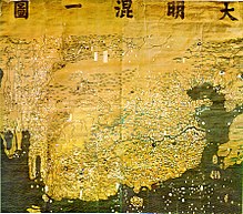 The Da Ming Hun Yi Tu map, dating
c.
1390
, exists in multicolour format.
The Da Ming Hun Yi Tu map, dating
c.
1390
, exists in multicolour format.
The multicolour map,
Da Ming Hunyi Tu
dates to the early
Ming dynasty
from about 1390, is in multicolour. The horizontal scale is 1:820,000 and the vertical scale is 1:1,060,000.
[46]
Many of the oldest surviving maps from China dates between the 16th to 17th centuries, these include the
Sihai Huayi Zongtu
(1532) and the
Shanhai Yudi Quantu
(1609).
[56]
Similar to these, the earliest European style map from China, the
Kunyu Wanguo Quantu
(1602) influenced and was exported to Japan
[57]
and Korea.
[58]
By this time, Jesuit missionaries contributed to similar maps such as the
Wanguo Quantu
(1620s)
[59]
and the
Kunyu Quantu
(1674).
[60]
While the
Selden Map
(
c.
17th
century) employs a system of navigational routes emanating from ports in China.
[61]
The
Mao Kun map
published in 1628 is thought to be based on a
strip map
dated to the voyages of
Zheng He
.
[62]
In 1579,
Luo Hongxian
published the
Guang Yutu
atlas, including more than 40 maps, a grid system, and a systematic way of representing major landmarks such as mountains, rivers, roads and borders. The
Guang Yutu
incorporates the discoveries of the naval explorer Zheng He's 15th-century voyages along the coasts of China, Southeast Asia, India and Africa.
[46]
Qing dynasty
[
edit
]
From the 16th and 17th centuries, several examples survive of maps focused on cultural information. Gridlines are not used on either
Yu Shi
's
Gujin xingsheng zhi tu
(1555) or
Zhang Huang
's
Tushu bian
(1613); instead, illustrations and annotations show mythical places, exotic foreign peoples, administrative changes and the deeds of historic and legendary heroes.
[46]
Also in the 17th century, an edition of a possible Tang dynasty map shows clear topographical
contour lines
.
[41]
: 546
Although
topographic
features were part of maps in China for centuries, a
Fujian
county official
Ye Chunji
(1532?1595) was the first to base county maps using on-site topographical
surveying
and observations.
[63]
Japan and Korea
[
edit
]
 The first Japanese printed map to depict the world, including Europe and America. Printed by woodblock in 1710, composed by the Buddhist monk
Rokashi Hotan
.
The first Japanese printed map to depict the world, including Europe and America. Printed by woodblock in 1710, composed by the Buddhist monk
Rokashi Hotan
.
 Map of the “Inhabited Quarter” by Sadiq Isfahani from
Jaunpur
c.1647. This was one of the only surviving Indian made maps.
Map of the “Inhabited Quarter” by Sadiq Isfahani from
Jaunpur
c.1647. This was one of the only surviving Indian made maps.
In 1402, Yi Hoe and Kwan Yun created a world map largely based from Chinese cartographers called the
Gangnido
map. It is currently one of the oldest surviving world maps from East Asia.
[64]
Another notable pre-modern map is the
Cheonhado
map developed in Korea in the 17th century.
[65]
Sekisui Nagakubo
produced a world map in 1785 called the
Comprehensive Map and Description of the Geography of the Myriad Countries of the Globe
(
地球萬國山海輿地全圖說
), mainly deriving it from an earlier map made by Matteo Ricci. The production was made by woodblock print and folded into paper boards, he made corrections and additions on top of Matteo's production. This was one of the earliest maps with longitude and latitude information in Japan and was written in
Katakana
.
[66]
Another well-known cartographer of the late-Edo period was
Ino Tadataka
, he is known for completing the first map of Japan using modern surveying techniques.
[67]
His most famous work, the
Dai Nihon Enkai Yochi Zenzu
(
大日本沿海輿地全?
)
consisted of three large map pages at a scale of 1:432,000 and it showed the entire country on eight pages at 1:216,000. Some of his maps are accurate to 1/1000 of a degree, which allowed it to become the definitive maps used in Japan for nearly a century. Maps based on his work were in use as late as 1924.
India
[
edit
]
 The
pundit (explorer)
cartographer
Nain Singh Rawat
(19th century) received a
Royal Geographical Society
gold medal in 1876.
The
pundit (explorer)
cartographer
Nain Singh Rawat
(19th century) received a
Royal Geographical Society
gold medal in 1876.
Ancient India
[
edit
]
Indian cartographic traditions covered the locations of the
Pole star
and other constellations of use.
[68]
: 330
These charts may have been in use by the beginning of the
Common Era
for purposes of navigation.
[68]
: 330
Detailed maps of considerable length describing the locations of settlements, sea shores, rivers, and mountains were also made.
[68]
: 327
The 8th-century scholar
Bhavabhuti
conceived paintings which indicated geographical regions.
[68]
: 328
Italian scholar Francesco Lorenzo Pulle reproduced a number of ancient Indian maps in his
magnum opus
La Cartografia Antica dell'India
.
[68]
: 327
Out of these maps, two have been reproduced using a manuscript of
Lokaprakasa
, originally compiled by the polymath Ksemendra (
Kashmir
, 11th century), as a source.
[68]
: 327
The other manuscript, used as a source by Pulle, is titled
Samgrahani
.
[68]
: 327
The early volumes of the
Encyclopædia Britannica
also described cartographic charts made by the
Dravidian people
of India.
[68]
: 330
Mughal era
[
edit
]
Maps from the
Ain-e-Akbari
, a
Mughal
document detailing India's history and traditions, contain references to locations indicated in earlier Indian cartographic traditions.
[68]
: 327
Another map describing the
kingdom of Nepal
, four feet in length and about two and a half feet in breadth, was presented to
Warren Hastings
.
[68]
: 328
In this map the mountains were elevated above the surface, and several geographical elements were indicated in different colors.
[68]
: 328
The scholar Sadiq Isfahani of
Jaunpur
compiled an
atlas
of the parts of the world which he held to be 'suitable for human life'.
[69]
The 32 sheet atlas?with maps oriented towards the south as was the case with Islamic works of the era?is part of a larger scholarly work compiled by Isfahani during 1647 CE.
[69]
According to Joseph E. Schwartzberg (2008): 'The largest known Indian map, depicting the former
Rajput
capital at
Amber
in remarkable house-by-house detail, measures 661 × 645 cm.
[70]
(260 × 254 in., or approximately 22 × 21 ft).'
[70]
Islamic cartographic schools
[
edit
]
Arab and Persian cartography
[
edit
]
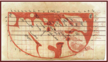
 Al-Masudi
's world map (10th century)
Al-Masudi
's world map (10th century)
In the Middle Ages, Muslim scholars continued and advanced on the mapmaking traditions of earlier cultures. Most used Ptolemy's methods; but they also took advantage of what explorers and merchants learned in their travels across the Muslim world, from Spain to India to Africa, and beyond in trade relationships with China, and Russia.
[26]
An important influence in the development of
cartography
was the patronage of the
Abbasid
caliph
,
al-Ma'mun
, who reigned from 813 to 833. He commissioned several geographers to remeasure the distance on earth that corresponds to one degree of celestial meridian. Thus his patronage resulted in the refinement of the definition of the mile used by Arabs (
m?l
in Arabic) in comparison to the
stadion
used by Greeks. These efforts also enabled Muslims to calculate the circumference of the earth. Al-Mamun also commanded the production of a large map of the world, which has not survived,
[71]
: 61?63
though it is known that its map projection type was based on
Marinus of Tyre
rather than
Ptolemy
.
[72]
: 193
Also in the 9th century, the
Persian mathematician
and geographer,
Habash al-Hasib al-Marwazi
, employed
spherical trigonometry
and
map projection
methods to convert
polar coordinates
to a different coordinate system centred on a specific point on the sphere, in this the
Qibla
, the direction to
Mecca
.
[73]
Ab? Rayh?n B?r?n?
(973?1048) later developed ideas which are seen as an anticipation of the polar coordinate system.
[74]
Around 1025, he describes a polar equi-
azimuthal equidistant projection
of the
celestial sphere
.
[75]
: 153
However, this type of projection had been used in ancient Egyptian star-maps and was not to be fully developed until the 15 and 16th centuries.
[76]
In the early 10th century,
Ab? Zayd al-Balkh?
, originally from
Balkh
, founded the "Balkh? school" of terrestrial mapping in
Baghdad
. The geographers of this school also wrote extensively of the peoples, products, and customs of areas in the Muslim world, with little interest in the non-Muslim realms.
[71]
The "Balkh? school", which included geographers such as
Estakhri
,
al-Muqaddasi
and
Ibn Hawqal
, produced world atlases, each one featuring a
world map
and twenty regional maps.
[72]
: 194
Suhr?b, a late 10th-century Muslim geographer, accompanied a book of geographical
coordinates
with instructions for making a rectangular world map, with
equirectangular projection
or cylindrical equidistant projection.
[71]
The earliest surviving rectangular coordinate map is dated to the 13th century and is attributed to Hamdallah al-Mustaqfi al-
Qazwini
, who based it on the work of Suhr?b. The
orthogonal
parallel lines were separated by one degree intervals, and the map was limited to Southwest Asia and Central Asia. The earliest surviving world maps based on a rectangular coordinate grid are attributed to al-Mustawfi in the 14th or 15th century (who used invervals of ten degrees for the lines), and to
Hafiz-i Abru
(died 1430).
[72]
: 200?01
Ibn Battuta
(1304?1368?) wrote "Rihlah" (Travels) based on three decades of journeys, covering more than 120,000 km through northern Africa, southern Europe, and much of Asia.
Islamic regional cartography
[
edit
]
Islamic regional cartography is usually categorized into three groups: that produced by the "
Balkh? school
", the type devised by
Muhammad al-Idrisi
, and the type that are uniquely found in the
Book of curiosities
.
[71]
The maps by the Balkh? schools were defined by political, not longitudinal boundaries and covered only the Muslim world. In these maps the distances between various "stops" (cities or rivers) were equalized. The only shapes used in designs were verticals, horizontals, 90-degree angles, and arcs of circles; unnecessary geographical details were eliminated. This approach is similar to that used in
subway
maps, most notable used in the "
London Underground
Tube Map
" in 1931 by
Harry Beck
.
[71]
: 85?87
Al-Idr?s? defined his maps differently. He considered the extent of the known world to be 160° in longitude, and divided the region into ten parts, each 16° wide. In terms of latitude, he portioned the known world into seven 'climes', determined by the length of the longest day. In his maps, many dominant geographical features can be found.
[71]
Book on the appearance of the Earth
[
edit
]
Muhammad ibn M?s? al-Khw?rizm?
's
Kit?b ??rat al-Ar?
("Book on the appearance of the Earth") was completed in 833. It is a revised and completed version of
Ptolemy
's
Geography
, consisting of a list of 2402 coordinates of cities and other geographical features following a general introduction.
[77]
Al-Khw?rizm?,
Al-Ma'mun
's most famous geographer, corrected Ptolemy's gross overestimate for the length of the
Mediterranean Sea
[72]
: 188
(from the
Canary Islands
to the eastern shores of the Mediterranean); Ptolemy overestimated it at 63 degrees of
longitude
, while al-Khwarizmi almost correctly estimated it at nearly 50 degrees of longitude. Al-Ma'mun's geographers "also depicted the
Atlantic
and Indian Oceans as
open bodies of water
, not land-locked seas as Ptolemy had done."
[78]
Al-Khwarizmi thus set the
Prime Meridian
of the
Old World
at the eastern shore of the Mediterranean, 10?13 degrees to the east of
Alexandria
(the prime meridian previously set by Ptolemy) and 70 degrees to the west of
Baghdad
. Most medieval Muslim geographers continued to use al-Khwarizmi's prime meridian.
[72]
: 188
Other prime meridians used were set by
Ab? Muhammad al-Hasan al-Hamd?n?
and
Habash al-Hasib al-Marwazi
at
Ujjain
, a centre of
Indian astronomy
, and by another anonymous writer at
Basra
.
[72]
: 189
Al-Biruni
[
edit
]
Abu Rayhan al-Biruni
(973?1048) gave an estimate of 6,339.6 km for the
Earth radius
, which is only 17.15 km less than the modern value of 6,356.7523142 km (WGS84 polar radius "b"). In contrast to his predecessors who measured the Earth's circumference by sighting the Sun simultaneously from two different locations, Al-Biruni developed a new method of using
trigonometric
calculations based on the angle between a
plain
and mountain top which yielded more accurate measurements of the Earth's circumference and made it possible for it to be measured by a single person from a single location.
[79]
[80]
[81]
Al-Biruni's method's motivation was to avoid "walking across hot, dusty deserts" and the idea came to him when he was on top of a tall mountain in India (present day
Pind Dadan Khan
,
Pakistan
).
[81]
From the top of the mountain, he sighted the
dip angle
which, along with the mountain's height (which he calculated beforehand), he applied to the
law of sines
formula. This was the earliest known use of dip angle and the earliest practical use of the law of sines.
[80]
[81]
Around 1025, Al-Biruni was the first to describe a polar equi-
azimuthal equidistant projection
of the
celestial sphere
.
[82]
In his
Codex Masudicus
(1037), Al-Biruni theorized the existence of a landmass along the vast ocean between Asia and Europe, or what is today known as the Americas. He deduced its existence on the basis of his accurate estimations of the
Earth's circumference
and
Afro-Eurasia
's size, which he found spanned only two-fifths of the Earth's circumference, and his discovery of the concept of
specific gravity
, from which he deduced that the geological processes that gave rise to
Eurasia
must've also given rise to lands in the vast ocean between Asia and Europe. He also theorized that the landmass must be inhabited by human beings, which he deduced from his knowledge of humans inhabiting the broad north?south band stretching from Russia to
South India
and
Sub-Saharan Africa
, theorizing that the landmass would most likely lie along the same band.
[83]
[84]
He was the first to predict "the existence of land to the east and west of Eurasia, which later on was discovered to be America and Japan".
[84]
Tabula Rogeriana
[
edit
]
 The
Tabula Rogeriana
, drawn by
Muhammad al-Idrisi
for
Roger II of Sicily
in 1154. Note that the north is at the bottom, and so the map appears "upside down" compared to modern
cartographic
conventions.
The
Tabula Rogeriana
, drawn by
Muhammad al-Idrisi
for
Roger II of Sicily
in 1154. Note that the north is at the bottom, and so the map appears "upside down" compared to modern
cartographic
conventions.
The
Arab geographer
,
Muhammad al-Idrisi
, produced his medieval atlas,
Tabula Rogeriana
or
The Recreation for Him Who Wishes to Travel Through the Countries
, in 1154. He incorporated the knowledge of Africa, the Indian Ocean and the Far East gathered by
Arab merchants
and explorers with the information inherited from the classical geographers to create the most accurate map of the world in pre-modern times.
[85]
With funding from
Roger II of Sicily
(1097?1154), al-Idrisi drew on the knowledge collected at the university of
Cordoba
and paid draftsmen to make journeys and map their routes. The book describes the earth as a sphere with a circumference of 22,900 miles (36,900 km) but maps it in 70 rectangular sections. Notable features include the correct dual sources of the Nile, the coast of Ghana and mentions of Norway. Climate zones were a chief organizational principle. A second and shortened copy from 1192 called
Garden of Joys
is known by scholars as the
Little Idrisi
.
[26]
On the work of al-Idrisi, S. P. Scott commented:
[85]
The compilation of Edrisi marks an era in the
history of science
. Not only is its historical information most interesting and valuable, but its descriptions of many parts of the earth are still authoritative. For three centuries geographers copied his maps without alteration. The relative position of the lakes which form the Nile, as delineated in his work, does not differ greatly from that established by Baker and Stanley more than seven hundred years afterwards, and their number is the same. The mechanical genius of the author was not inferior to his erudition. The celestial and terrestrial
planisphere
of silver which he constructed for his royal patron was nearly six feet in diameter, and weighed four hundred and fifty pounds; upon the one side the zodiac and the constellations, upon the other?divided for convenience into segments?the bodies of land and water, with the respective situations of the various countries, were engraved.
?
S. P. Scott, History of the Moorish Empire in Europe
Al-Idrisi's atlas, originally called the
Nuzhat
in Arabic, served as a major tool for Italian, Dutch and French mapmakers from the 16th century to the 18th century.
[86]
Piri Reis map of the Ottoman Empire
[
edit
]
 Surviving fragment of the
first World Map
of
Piri Reis
(1513) showing parts of the Americas.
Surviving fragment of the
first World Map
of
Piri Reis
(1513) showing parts of the Americas.
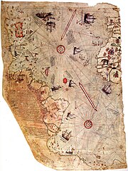
The Ottoman cartographer
Piri Reis
published navigational maps in his
Kitab-ı Bahriye
. The work includes an atlas of charts for small segments of the mediterranean, accompanied by sailing instructions covering the sea. In the second version of the work, he included a map of the Americas.
[71]
: 106
The
Piri Reis map
drawn by the Ottoman cartographer
Piri Reis
in 1513, is one of the oldest surviving maps to show the Americas.
[87]
: 268?272
[88]
[89]
[90]
Medieval Europe
[
edit
]
 The
Gough Map
, a road map of 14th-century Britain
The
Gough Map
, a road map of 14th-century Britain
Medieval maps and the Mappa Mundi
[
edit
]
Medieval maps of the world in Europe were mainly symbolic in form along the lines of the much earlier
Babylonian World Map
. Known as
Mappa Mundi
(cloths or charts of the world) these maps were circular or symmetrical cosmological diagrams representing the Earth's single land mass as disk-shaped and surrounded by ocean.
[6]
 Map of the
Holy Land
,
Pietro Vesconte
, 1321. Described by
Adolf Erik Nordenskiold
as "the first non-Ptolemaic map of a definite country".
[91]
Map of the
Holy Land
,
Pietro Vesconte
, 1321. Described by
Adolf Erik Nordenskiold
as "the first non-Ptolemaic map of a definite country".
[91]
Italian cartography and the birth of portolan charts
[
edit
]
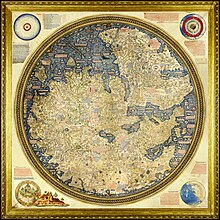 The
Fra Mauro map
, a medieval European map, was made around 1450 by the Italian monk
Fra Mauro
. It is a circular world map drawn on parchment and set in a wooden frame, about two meters in diameter.
The
Fra Mauro map
, a medieval European map, was made around 1450 by the Italian monk
Fra Mauro
. It is a circular world map drawn on parchment and set in a wooden frame, about two meters in diameter.
Roger Bacon
's investigations of map projections and the appearance of
portolano
and then
portolan charts
for plying the European trade routes were rare innovations of the period. The Majorcan school is contrasted with the contemporary
Italian cartography school
. The
Carta Pisana
portolan chart, made at the end of the 13th century (1275?1300), is the oldest surviving
nautical chart
(that is, not simply a map but a document showing accurate navigational directions).
[92]
Majorcan cartographic school and the "normal" portolan chart
[
edit
]
The
Majorcan cartographic school
was a predominantly Jewish cooperation of
cartographers
,
cosmographers
and
navigational instrument
-makers in late 13th to the 14th and 15th-century
Majorca
. With their multicultural heritage the Majorcan cartographic school experimented and developed unique cartographic techniques most dealing with the Mediterranean, as it can be seen in the
Catalan Atlas
.
[93]
The Majorcan school was (co-)responsible for the invention (c.1300) of the "Normal
Portolan chart
". It was a contemporary superior, detailed nautical model chart, gridded by compass lines.
Polynesian stick charts
[
edit
]
 A chart of an unidentified area
The
Polynesian peoples
who explored and settled the Pacific islands in the first two millennia AD used maps to navigate across large distances. A surviving map from the
Marshall Islands
uses sticks tied in a grid with palm strips representing wave and wind patterns, with shells attached to show the location of islands.
[94]
Other maps were created as needed using temporary arrangements of stones or shells.
[95]
Modern era
[
edit
]
Iberian cartography in the Age of Exploration
[
edit
]
In the
Renaissance
, with the renewed interest in classical works, maps became more like surveys once again, while European exploration of the Americas and their subsequent effort to control and divide those lands revived interest in scientific mapping methods. Peter Whitfield, the author of several books on the history of maps, credits European mapmaking as a factor in the global spread of western power: "Men in Seville, Amsterdam or London had access to knowledge of America, Brazil, or India, while the
native peoples
knew only their own immediate environment" (Whitfield). Jordan Branch and his advisor,
Steven Weber
, propose that the power of large kingdoms and nation states of later history are an inadvertent byproduct of 15th-century advances in map-making technologies.
[96]
[97]
During the 15th and 16th centuries, Iberian powers (
Kingdom of Castile
and
Kingdom of Portugal
) were at the vanguard of European overseas exploration and mapping the coasts of the Americas, Africa, and Asia, in what came known as the
Age of Discovery
(also known as the
Age of Exploration
). Spain and
Portugal
were magnets for the talent, science and technology from the
Italian city-states
.
Portugal's methodical expeditions
started in 1419 along West Africa's coast under the sponsorship of
Prince Henry the Navigator
, with
Bartolomeu Dias
reaching the
Cape of Good Hope
and entering the Indian Ocean in 1488. Ten years later, in 1498,
Vasco da Gama
led the first fleet around Africa to India, arriving in
Calicut
and starting a maritime route from Portugal to India. Soon, after
Pedro Alvares Cabral
reaching Brazil (1500), explorations proceed to Southeast Asia, having sent the first direct European maritime trade and diplomatic missions to
Ming China
and to Japan (1542).
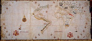
 World Map by
Juan de la Cosa
(1500), the first map showing the Americas.
World Map by
Juan de la Cosa
(1500), the first map showing the Americas.
In 1492, when a Spanish expedition headed by
Genoese
explorer
Christopher Columbus
sailed west to find a new trade route to the Far East but inadvertently found the Americas. Columbus's first two voyages (1492?93) reached the
Bahamas
and various
Caribbean islands
, including
Hispaniola
,
Puerto Rico
and
Cuba
. The Spanish cartographer and explorer
Juan de la Cosa
sailed with Columbus. He created the first known cartographic representations showing both the Americas. The post-1492 era is known as the period of the
Columbian Exchange
, a dramatically widespread exchange of animals, plants, culture, human populations (including slaves), communicable disease, and ideas between the American and Afro-Eurasian hemispheres following the
Voyages of Christopher Columbus
to the Americas.
The
Magellan-Elcano circumnavigation
was the first known voyage around the world in human history. It was a Spanish expedition that sailed from
Seville
in 1519 under the command of Portuguese navigator
Ferdinand Magellan
in search of a maritime path from the Americas to the East Asia across the Pacific Ocean. Following Magellan's death in Mactan (
Philippines
) in 1521,
Juan Sebastian Elcano
took command of the expedition, sailing to
Borneo
, the
Spice Islands
and back to Spain across the Indian Ocean, round the Cape of Good Hope and north along the west coast of Africa. They arrived in Spain three years after they left, in 1522.
- c.
1485
: Portuguese cartographer
Pedro Reinel
made the oldest known signed Portuguese nautical chart.
- 1492
: Cartographer
Jorge de Aguiar
made the oldest known signed and dated Portuguese nautical chart.
- 1537
: Much of Portuguese mathematician and cosmographer
Pedro Nunes
' work related to
navigation
. He was the first to understand why a ship maintaining a steady
course
would not travel along a
great circle
, the shortest path between two points on Earth, but would instead follow a
spiral
course, called a
loxodrome
. These lines, also called
rhumb lines
, maintain a fixed angle with the
meridians
. In other words, loxodromic curves are directly related to the construction of the Nunes
connection
, also called navigator connection. In his
Treatise in Defense of the Marine Chart
(1537), Nunes argued that a
nautical chart
should have its parallels and meridians shown as straight lines. Yet he was unsure how to solve the problems that this caused, a situation that lasted until
Mercator
developed the
projection
bearing his name. The
Mercator Projection
is the system which is still used.
First maps of the Americas
[
edit
]
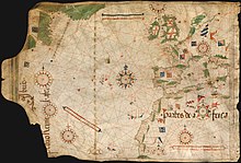 Nautical chart by
Pedro Reinel
(
c.
1504
), one of the first based on astronomical observations and to depict a scale of latitudes.
Nautical chart by
Pedro Reinel
(
c.
1504
), one of the first based on astronomical observations and to depict a scale of latitudes.
- 1500
: The Spanish cartographer and explorer
Juan de la Cosa
created the first known cartographic representations showing both the Americas as well as Africa and Eurasia.
- 1502
: Unknown Portuguese cartographer made the
Cantino planisphere
, the first nautical chart to implicitly represent latitudes.
- 1504
: Portuguese cartographer
Pedro Reinel
made the oldest known nautical chart with a scale of latitudes.
- 1519
: Portuguese cartographers
Lopo Homem
,
Pedro Reinel
and
Jorge Reinel
made the group of maps known today as the
Miller Atlas
or
Lopo Homem ? Reineis Atlas
.
- 1530
:
Alonzo de Santa Cruz
, Spanish cartographer, produced the first map of magnetic variations from true north. He believed it would be of use in finding the correct longitude. Santa Cruz also designed new nautical instruments,
[98]
and was interested in navigational methods.
Padron Real of the Spanish Empire
[
edit
]
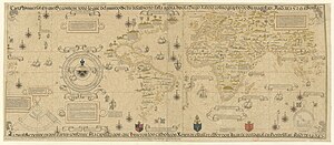
 The
Salviati Planisphere
, a 1526 version of the
Padron Real
provided by
Charles V
to
the cardinal
who officiated his wedding to
Isabella of Portugal
.
The
Salviati Planisphere
, a 1526 version of the
Padron Real
provided by
Charles V
to
the cardinal
who officiated his wedding to
Isabella of Portugal
.
 The Propaganda Map, a 1529 version of the Padron Real now held by the
Vatican Library
.
The Propaganda Map, a 1529 version of the Padron Real now held by the
Vatican Library
.
Founded 1504 in
Seville
, the Spanish
House of Trade
(
Casa de Contratacion
) kept a large contingent of cartographers as Spain's overseas empire expanded. A
royal standard map
(
Padron Real
) was established in 1508 and updated periodically as more information became available from major expeditions returning to Seville.
[99]
[100]
[101]
This continued a practice of long standing in Portugal, whose
Padrao Real
was kept in the
Guinea
and
India Houses
(
Casa da Guine
and
da India
) within the royal palace in
Lisbon
.
The originals of the Spanish and Portuguese maps are now lost but copies of known provenance are held by the
Vatican Library
; the
Biblioteca Estense
in
Modena
, Italy; and the
Anna Amalia Bibliothek
in
Weimar
, Germany. The 1527 and 1529 copies of the Padron Real under
Diogo Ribeiro
, a Portuguese cartographer working for Spain, are particularly praised as the first scientific world map.
[102]
Incorporating information from the
Magellan
,
Gomez
, and
Loaysa expeditions
and the
geodesic
research undertaken to codify the demarcation lines established by the
treaties of Tordesillas
and
Zaragoza
, these editions of the Padron Real show for the first time the full extension of the Pacific Ocean and the continuous coast of North America. They also very precisely delineate the coasts of
Central
and South America, although Portugal's control of the African trade routes left the Indian Ocean less exact.
Two prominent cosmographers (as mapmakers were then known) of the House of Trade were
Alonso de Santa Cruz
and Juan Lopez de Velasco, who directed mapmaking under
Philip II
without ever going to the New World. Their maps were based on information they received from returning navigators. Using repeatable principles that underpin mapmaking, their mapmaking techniques could be employed anywhere. Philip II sought extensive information about his overseas empire, both in written textual form and in the production of maps.
[103]
German cartography
[
edit
]
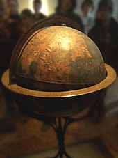 Martin Behaim
's
Erdapfel
(1492) is considered to be the oldest surviving terrestrial
globe
.
Martin Behaim
's
Erdapfel
(1492) is considered to be the oldest surviving terrestrial
globe
.
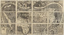 Universalis Cosmographia
, the
Waldseemuller wall map
dated 1507, depicts the Americas, Africa, Europe, Asia, and the Pacific Ocean separating Asia from the Americas, by the Italian
Amerigo Vespucci
.
Universalis Cosmographia
, the
Waldseemuller wall map
dated 1507, depicts the Americas, Africa, Europe, Asia, and the Pacific Ocean separating Asia from the Americas, by the Italian
Amerigo Vespucci
.
Dutch and Flemish cartography
[
edit
]
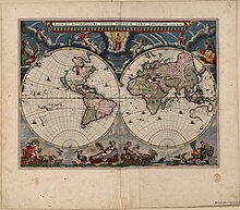 Blaeu
's
world map
, originally prepared by
Joan Blaeu
for his
Atlas Maior
, published in the first book of the
Atlas Van Loon
(1664)
Blaeu
's
world map
, originally prepared by
Joan Blaeu
for his
Atlas Maior
, published in the first book of the
Atlas Van Loon
(1664)
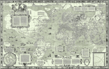 The
Mercator 1569 world map
The
Mercator 1569 world map
Leuven
, Antwerp, and
Amsterdam
were the main centres of the Netherlandish school of cartography in its golden age (the 16th and 17th centuries, approximately 1570?1670s). The Golden Age of Dutch cartography started in Flanders (mainly in Leuven and Antwerp) when
Gerardus Mercator
and
Abraham Ortelius
found its fullest expression during the 17th century with the production of monumental multi-volume world atlases in the
Dutch Republic
(mainly in Amsterdam) by competing mapmaking firms led by
Lucas Waghenaer
,
Joan Blaeu
,
Jan Janssonius
,
Claes Janszoon Visscher
, and
Frederik de Wit
.
[104]
Notable representatives of the
Netherlandish school
of cartography and geography (1500s?1600s) include:
Franciscus Monachus
,
Gemma Frisius
,
Gaspard van der Heyden
,
Christophe Plantin
,
Lucas Waghenaer
,
Jacob van Deventer
,
Willebrord Snell
,
Hessel Gerritsz
,
Petrus Plancius
,
Jodocus Hondius
,
Henricus Hondius II
,
Hendrik Hondius I
,
Willem Blaeu
,
Joan Blaeu
,
Andreas Cellarius
,
Gerard de Jode
,
Cornelis de Jode
,
Nicolaes Visscher I
and
Nicolaes Visscher II
.
Gerardus Mercator, the German-Netherlandish cartographer and geographer with a vast output of wall maps, bound maps, globes and scientific instruments but his greatest legacy was the
mathematical projection
he devised for his
1569 world map
. The
Mercator projection
is an example of a
cylindrical projection
in which the
meridians
are straight and perpendicular to the parallels. As a result, the map has a constant width and the parallels are stretched east?west as the poles are approached. Mercator's insight was to stretch the separation of the parallels in a way which exactly compensates for their increasing length, thus preserving shapes of small regions, albeit at the expense of global distortion. Such a
conformal
map projection necessarily transforms
rhumb lines
, sailing courses of a constant bearing, into straight lines on the map thus greatly facilitating navigation. That this was Mercator's intention is clear from the title:
Nova et Aucta Orbis Terrae Descriptio ad Usum Navigantium Emendate Accommodata
which translates as "New and more complete representation of the terrestrial globe properly adapted for use in navigation". Although the projection's adoption was slow, by the end of the seventeenth century it was in use for naval charts.
[
citation needed
]
Mercator spent the last thirty years of his life working on a vast project, the
Cosmographia
;
[b]
a description of the whole universe including the creation and a description of the topography, history and institutions of all countries. The word
atlas
makes its first appearance in the title of the final volume: "Atlas sive cosmographicae meditationes de fabrica mundi et fabricati figura". This translates as
Atlas OR cosmographical meditations upon the creation of the universe, and the universe as created,
thus providing Mercator's definition of the term
atlas
. These volumes devote slightly less than one half of their pages to maps: Mercator did not use the term solely to describe a bound collection of maps. His choice of title was motivated by his respect for
Atlas
"King of
Mauretania
"
[105]
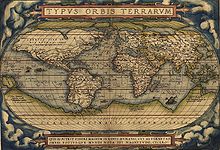 World map
Theatrum Orbis Terrarum
by
Ortelius
(1570)
World map
Theatrum Orbis Terrarum
by
Ortelius
(1570)
Abraham Ortelius is generally recognized as the creator of the first modern atlas, the
Theatrum Orbis Terrarum
.
[106]
Triangulation
had first emerged as a
map making
method in the early 16th century when
Gemma Frisius
set out the idea in his
Libellus de locorum describendorum ratione
(
Booklet concerning a way of describing places
).
[107]
[108]
[109]
The Dutch cartographer
Jacob van Deventer
was among the first to make systematic use of triangulation, the technique whose theory was described by Frisius in his 1533 book.
The modern systematic use of
triangulation networks
stems from the work of the Dutch mathematician
Willebrord Snell
(born Willebrord Snel van Royen), who in 1615 surveyed the distance from
Alkmaar
to
Bergen op Zoom
, approximately 70 miles (110 km), using a chain of quadrangles containing 33 triangles in all.
[110]
[111]
[112]
The two towns were separated by one degree on the
meridian
, so from his measurement he was able to calculate a value for the circumference of the earth ? a feat celebrated in the title of his book
Eratosthenes Batavus
(
The Dutch
Eratosthenes
), published in 1617. Snell's methods were taken up by
Jean Picard
who in 1669?1670 surveyed one degree of latitude along the
Paris Meridian
using a chain of thirteen triangles stretching north from Paris to the clocktower of
Sourdon
, near
Amiens
.
The first printed atlas of
nautical charts
(
De Spieghel der Zeevaerdt
or
The Mirror of Navigation
/
The Mariner's Mirror
) was produced by Lucas Waghenaer in
Leiden
in 1584. This atlas was the first attempt to systematically codify nautical maps. This chart-book combined an atlas of nautical charts and sailing directions with instructions for navigation on the western and north-western coastal waters of Europe. It was the first of its kind in the history of maritime cartography.
[113]
[114]
[115]
[116]
In 1660, the German-born Dutch cartographer
Andreas Cellarius
had his
star atlas
(
Harmonia Macrocosmica
) published by
Jan Janssonius
in Amsterdam.
In the long run the competition between map-making firms Blaeu and Janssonius resulted in the publication of an
Atlas Maior
or 'Major Atlas'. In 1662 the Latin edition of Joan Blaeu's
Atlas Maior
appeared in eleven volumes and with approximately 600 maps. In the years to come French and Dutch editions followed in twelve and nine volumes respectively. Purely judging from the number of maps in the
Atlas Maior
, Blaeu had outdone his rival Jan Janssonius. And also from a commercial point of view it was a huge success. Also due to the superior typography the
Atlas Maior
by Blaeu soon became a status symbol for rich citizens. Costing 350 guilders for a non-coloured and 450 guilders for a coloured version, the atlas was the most precious book of the 17th century. However, the
Atlas Maior
was also a turning point: after that time the role of Dutch cartography (and Netherlandish cartography in general) was finished. Janssonius died in 1664 while a great fire in 1672 destroyed one of Blaeu's print shops. In that fire a part of the copperplates went up in flames. Fairly soon afterwards Joan Blaeu died, in 1673. The almost 2,000 copperplates of Janssonius and Blaeu found their way to other publishers.
French cartography
[
edit
]
Historian David Buisseret has traced the roots of the flourishing of cartography in the 16th and 17th centuries in Europe. He noted five distinct reasons: 1) admiration of
antiquity
, especially the rediscovery of
Ptolemy
, considered to be the first geographer; 2) increasing reliance on measurement and quantification as a result of the scientific revolution; 3) refinements in the visual arts, such as the discovery of
perspective
, that allowed for better representation of spatial entities; 4) development of estate property; and 5) the importance of mapping to nation-building.
[117]
The reign of Louis XIV is generally considered to represent the beginning of cartography as a science in France.
[118]
: 42
The evolution of cartography during the transition between the 17th and 18th centuries involved advancements on a technical level, as well as those on a representative level. According to Marco Petrella, the map developed "from a tool used to affirm the administrative borders of the reign and its features…into a tool which was necessary to intervene in territory and thus establish control of it."
[119]
[
page needed
]
Because unification of the kingdom necessitated well-kept records of land and tax bases, Louis XIV and members of the royal court pushed the development and progression of the sciences, especially cartography. Louis XIV established the
Academie des Sciences
in 1666, with the expressed purpose of improving cartography and sailing charts. It was found that all the gaps of knowledge in geography and navigation could be accounted for in the further exploration and study of astronomy and geodesy.
[120]
[
page needed
]
Colbert also attracted many foreign scientists to the
Academie des Sciences
to support the pursuit of scientific knowledge.
[118]
: 45
Under the auspices of the Sun King and Jean-Baptiste Colbert, members of the
Academie des Sciences
made many breakthrough discoveries within the realm of cartography to ensure accuracy of their works. Among the more prominent work done with the
Academie
was that done by
Giovanni Domenico Cassini
, who perfected a method of determining longitude by the observation of movement of
Jupiter
's satellites.
[121]
Cassini, along with the aid and support of mathematician
Jean Picard
, developed a system of uniting the provincial topographical information into a comprehensive map of the country, through a network of surveyed triangles. It established a practice that was eventually adopted by all nations in their project to map the areas under their domain.
[120]
: 18
For their method of triangulation, Picard and Cassini used the
meridian arc
of Paris-Amiens as their starting point.
[119]
: 21
Jean-Baptiste Colbert
, the secretary of home affairs and prominent member of Louis XIV's royal court, set out to develop the resource base of the nation and to develop a system of infrastructure that could restore the French economy. He wanted to generate income for the high expenses incurred by Louis XIV. What Colbert lacked in his pursuit of the development of the economy was a map of the entire country. France, like all other countries of Europe, operated on local knowledge. Within France, there were local systems of measuring weight and taxes; a uniform notion of land surveying did not exist.
[120]
: 16
The advancements made by the members of the
Academie des Sciences
proved instrumental as a tool to aid reform within the nation. Cartography was an important element in two major reforms undertaken by Colbert: the reform of the royal forest, a project undertaken beginning in 1661, and naval reform, initiated in 1664.
[118]
: 44
In 1663?1664 Colbert tried to collect information from the provinces to accurately assess the income within the kingdom, necessary information for economic and tax reform. Colbert asked the provincial representatives of the king, the intendants, to gather existing maps of territory within the provinces and check them for accuracy. If they were found not to be accurate, the Royal Geographer, Nicolas Sanson, was to edit them, basing his information on the reports prepared by the intendants. The operation did not succeed because the
Academie des Sciences
did not believe it had a strong enough basis in cartographic methodology.
[118]
: 45
The importance of cartography to the mechanisms of the state, however, continued to grow.
In the 1670s the astronomer
Giovanni Domenico Cassini
began work on the first modern
topographic map
in France. It was completed in 1789 or 1793 by his grandson
Cassini de Thury
.
[122]
[123]
Paris as the center of cartography
[
edit
]
The seventeenth century marked the emergence of France as the center of the map trade in Europe, with much of the production and distribution of maps taking place in the capital Paris.
[124]
: 33?45
In conjunction with the support of scientific development, the royal court encouraged the work of arts and artisans. This royal patronage attracted artists to Paris. As a result, many mapmakers, such as
Nicolas Sanson
and Alexis-Hubert Jaillot, moved to the national capital from the peripheries of the provinces.
[124]
: 34
Many of the agents of cartography, including those involved in the creation, production and distribution of maps in Paris, came to live in the same section of the capital city. Booksellers congregated on rue St-Jacques along the left bank of the Seine, while engravers and cartographers lived along the quai de l'Horloge on the
Ile de la Cite
(See Figure 1). Regulations enacted by the
communautes
informed the location of the libraries. These regulations included that each bookseller-printer was to have one shop, which had to be located in the university quarter or on the
quai de l'Horloge
. These restrictions enabled authorities to more easily inspect their businesses to enforce other regulations such as: printer need to register the number of presses they owned, and any books printed had to be registered and approved by the royal court before sales.
[124]
: 34
Opticians were also located ton he
Quai de l'Horloge
. Their tools ? squares, rules, compasses and dividers ? were essential to the practice of cartography.
[124]
: 37
Many of the cartographers who worked in Paris never set foot outside the city; they did not gather firsthand knowledge for their maps. They were known as the
geographes de cabinet
. An example of a cartographer who relied on other sources was
Jean-Baptiste Bourgignon d'Anville
, who compiled his information from ancient and modern sources, verbal and pictorial, published and even unpublished sources.
[124]
: 39
Dieppe school of cartographers
[
edit
]
The
Dieppe maps
are a series of world maps produced in
Dieppe
, France, in the mid 16th century. They are large hand-produced maps, commissioned for wealthy and royal patrons, including
Henry II of France
and
Henry VIII of England
. The Dieppe school of
cartographers
included
Pierre Desceliers
,
Johne Rotz
,
Guillaume Le Testu
,
Guillaume Brouscon
and
Nicolas Desliens
.
18th-century developments
[
edit
]
 A general map of the world by
Samuel Dunn
, 1794, containing
star chart
, map of the
Solar System
, map of the Moon and other features along with Earth's both hemispheres.
A general map of the world by
Samuel Dunn
, 1794, containing
star chart
, map of the
Solar System
, map of the Moon and other features along with Earth's both hemispheres.
The Vertical Perspective projection was first used by the German map publisher
Matthias Seutter
in 1740. He placed his observer at ~12,750 km distance. This is the type of projection used today by Google Earth.
[76]
The changes in the use of military maps was also part of the modern
Military Revolution
, which changed the need for information as the scale of conflict increases as well. This created a need for maps to help with "... consistency, regularity and uniformity in military conflict."
[125]
The final form of the
equidistant conic projection
was constructed by the French astronomer
Joseph-Nicolas Delisle
in 1745.
[76]
The Swiss mathematician
Johann Lambert
invented several hemispheric map projections. In 1772 he created the
Lambert conformal conic
and
Lambert azimuthal equal-area projections
.
[76]
The
Albers equal-area conic projection
features no distortion along standard parallels. It was invented by
Heinrich Albers
in 1805.
[76]
[126]
In 1715
Herman Moll
published the
Beaver Map
, one of the most famous early maps of North America, which he copied from a 1698 work by
Nicolas de Fer
.
In 1763?1767 Captain
James Cook
mapped
Newfoundland
.
In 1777 Colonel
Joseph Frederick Wallet DesBarres
created a monumental four volume atlas of North America,
Atlantic Neptune
.
 A survey of
Boston Harbor
from
Atlantic Neptune
.
A survey of
Boston Harbor
from
Atlantic Neptune
.
In the United States in the 18th and 19th centuries, explorers mapped trails and
army engineers
surveyed government lands. Two agencies were established to provide more detailed, large-scale mapping: the
U.S. Geological Survey
and
U.S. Coast and Geodetic Survey
(now the
National Geodetic Survey
, a part of the
National Oceanic and Atmospheric Administration
).
19th-century developments
[
edit
]
 "Mapa de los Estados Unidos de Mejico
by John Distrunell, the 1847 map used during the negotiations of the
Treaty of Guadalupe Hidalgo
ending the
Mexican?American War
.
"Mapa de los Estados Unidos de Mejico
by John Distrunell, the 1847 map used during the negotiations of the
Treaty of Guadalupe Hidalgo
ending the
Mexican?American War
.
During his travels in Spanish America (1799?1804)
Alexander von Humboldt
created the most accurate map of
New Spain
(now Mexico) to date. Published as part of his
Essai politique sur le royaume de la Nouvelle-Espagne
(1811) (
Political Essay on the Kingdom of New Spain
), Humboldt's
Carte du Mexique
(1804) was based on existing maps of Mexico, but with Humboldt's careful attention to latitude and longitude. Landing at the Pacific coast port of Acapulco in 1803, Humboldt did not leave the port area for Mexico City until he produced a map of the port; when leaving he drew a map of the east coast port of Veracruz, as well as a map of the central plateau of Mexico. Given royal authorization from the Spanish crown for his trip, crown officials in Mexico were eager to aid Humboldt's research. He had access to
Jose Antonio de Alzate y Ramirez
's
Mapa del Arzobispado de Mexico
(1768), which he deemed "very bad", as well as the seventeenth-century map of greater Mexico City by savant Don
Carlos de Siguenza y Gongora
.
[127]
John Disturnell, a businessman and publisher of guidebooks and maps, published
Mapa de los Estados Unidos de Mejico
, which was used in the negotiations between the U.S. and Mexico in the
Treaty of Guadalupe Hidalgo
(1848), following the
Mexican?American War
, based on the 1822 map by U.S. cartographer
Henry Schenck Tanner
.
[128]
This map has been described as showing U.S.
Manifest Destiny
; a copy of the map was offered for sale in 2016 for $65,000. Map making at that time was important for both Mexico and the United States.
[129]
The Greenwich
prime meridian
became the international standard reference for cartographers in 1884.
20th-century developments
[
edit
]
During the 20th century, maps became more abundant due to improvements in printing and photography that made production cheaper and easier. Airplanes made it possible to photograph large areas at a time.
Two-point equidistant projection
was first drawn up by
Hans Maurer
in 1919. In this projection the distance from any point on the map to either of the two regulating points is accurate.
[76]
The
loximuthal projection
was constructed by
Karl Siemon
in 1935 and refined by
Waldo Tobler
in 1966.
[76]
Since the mid-1990s, the use of computers in map making has helped to store, sort, and arrange data for mapping to create map projections.
[130]
Contemporary developments
[
edit
]
Software development
[
edit
]
Nowadays map-making heavily relies on computer software to develop and provide a variety of services, a trend that already started at the end of the previous century. For instance, self-location, browser search of places, business, products, and area, and distance calculation. At the present time, computer-based software is dominated by big companies that offer their services to a worldwide public, such as
Google Maps
,
Apple Maps
,
Bing Maps
,
National Geographic Maps
,
ESRI
Geographic Information System (GIS)
,
CartoDB
,
Mapbox
,
Waze
, etc. Many other state-based, regional and smaller initiatives, and companies offer their services. The
list of online map services
is quite long and is growing every day.
Historical map collections
[
edit
]
Recent development also include the integration of ancient maps and modern scholar research combined with modern computer software to elaborate periodical history maps. Initiatives such as
Euratlas History Maps
(which covers the whole of Europe from the year 1 AD to the present),
Centennia Historical Atlas
(which covers Europe from the year 1000AD to the present),
Geacron
, and many others who work in what is called
historical cartography
. These maps include evolution of countries, provinces and cities, wars and battles, the
history of border changes
, etc.
Today historical cartography is thriving. The specialization of map services is ever growing. New map projections are still being developed, university map collections, such as
Perry?Castaneda Library Map Collection
at the
University of Texas
, offer better and more diverse maps and map tools every day, making available for their students and the broad public ancient maps that in the past were difficult to find.
David Rumsey Historical Map Collection
is nowadays a worldwide known initiative.
Self-publishing tools and collaborative mapping
[
edit
]
Never in the past there were many "edit-yourself" map tools and software available for non-specialist. Map blogs and self-publishing are common.
[
citation needed
]
In 2004,
Steve Coast
created
OpenStreetMap
, a
collaborative project
to create a
free
editable map of the world. The creation and growth of OpenStreetMap has been motivated by restrictions on use or availability of map information across much of the world, and the advent of inexpensive portable
satellite navigation
devices.
[131]
[132]
Organizations
[
edit
]
In 1921, the
International Hydrographic Organization
(IHO) was set up, and it constitutes the authority on
hydrographic
surveying and nautical charting.
[133]
The current defining document is the Special publication S-23,
Limits of Oceans and Seas
, 3rd edition, 1953. The second edition dated back to 1937, and the first to 1928. A fourth edition draft was published in 1986 but so far several naming disputes (such as the one over the
Sea of Japan
) have prevented its ratification.
History of cartography's technological changes
[
edit
]
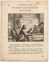 A portrait of a mapmaker looking up intently from his charts and holding a caliper, 1714.
In cartography, technology has continually changed to meet the demands of new generations of mapmakers and map users. The first maps were manually constructed with brushes and parchment and therefore varied in quality and were limited in distribution. The advent of the
compass
,
printing press
,
telescope
,
sextant
,
quadrant
and
vernier
allowed for the creation of far more accurate maps and the ability to make accurate reproductions.
Professor Steven Weber
of the
University of California, Berkeley
, has advanced the hypothesis that the concept of the "
nation state
" is an inadvertent byproduct of 15th-century advances in map-making technologies.
[96]
[97]
Advances in photochemical technology, such as the
lithographic
and
photochemical processes
, have allowed for the creation of maps that have fine details, do not distort in shape and resist moisture and wear. This also eliminated the need for engraving which further shortened the time it takes to make and reproduce maps.
 A US civil war hachure paper map made in 1867 by Cartographer Nathaniel Michler vs. modern aerial photos over Chancellorsville, Virginia
[134]
A US civil war hachure paper map made in 1867 by Cartographer Nathaniel Michler vs. modern aerial photos over Chancellorsville, Virginia
[134]
In the mid-to-late 20th century, advances in electronic technology have led to further revolution in cartography. Specifically computer hardware devices such as computer screens, plotters, printers, scanners (remote and document) and analytic stereo plotters along with visualization, image processing, spatial analysis and database software, have democratized and greatly expanded the making of maps, particularly with their ability to produce maps that show slightly different features, without engraving a new printing plate. See also
digital raster graphic
and
History of web mapping
.
Aerial photography
and
satellite imagery
have provided high-accuracy, high-throughput methods for mapping physical features over large areas, such as coastlines, roads, buildings, and topography.
[134]
See also
[
edit
]
Related histories
[
edit
]
Notes
[
edit
]
Citations
[
edit
]
- ^
Wolodtschenko, Alexander; Forner, Thomas (2007).
"Prehistoric and Early Historic Maps in Europe: Conception of Cd-Atlas"
(PDF)
.
E-perimetron
.
2
(2).
ISSN
1790-3769
. Retrieved
24 January
2015
.
- ^
Schøyen Collection
,
MS 5087/36, Cylcon (Yurda), possibly with map of Darling River
Archived
24 April 2022 at the
Wayback Machine
, commentary.
- ^
"Ice Age star map discovered"
.
BBC News
. 9 August 2000.
- ^
"Astronomical Artefacts and Cuneiform Tablets, etc"
.
Web Site For Gary D. Thompson, West Melton, Australia
. Archived from
the original
on 30 January 2007
. Retrieved
15 May
2008
.
- ^
"Published scientific papers ? MR"
.
Institute for Interdisciplinary Studies
. Archived from
the original
on 28 August 2008
. Retrieved
15 May
2008
.
- ^
a
b
c
d
e
f
Frenz, Thomas.
"Tutorials in the History of Cartography ? Overview"
. Archived from
the original
on 6 July 2006.
- ^
Choi, Charles; Catherine Brahic (2009). "Found: a pocket guide to prehistoric Spain".
New Scientist
.
203
(2720): 8?9.
doi
:
10.1016/S0262-4079(09)62055-8
.
- ^
Utrilla, P; C. Mazo; M. C. Sopena; M. Martinez-Bea; R. Domingo (2009). "A palaeolithic map from 13,660 calBP: engraved stone blocks from the Late Magdalenian in Abauntz Cave (Navarra, Spain)".
Journal of Human Evolution
.
57
(2): 99?111.
doi
:
10.1016/j.jhevol.2009.05.005
.
PMID
19625071
.
- ^
"
henrydavis.com
? Ancient Images"
.
Henry Davis Consulting
.
- ^
Meece, Stephanie (2006).
"A bird's eye view ? of a leopard's spots. The Catalhoyuk 'map' and the development of cartographic representation in prehistory"
.
DSpace @ Cambridge
.
- ^
Clement Nicolas, Yvan Pailler, Pierre Stephan, Julie Pierson, Laurent Aubry, et al.. La carte et le territoire : la dalle gravee du Bronze ancien de Saint-Belec (Leuhan, Finistere). Bulletin de la Societe prehistorique francaise, Societe prehistorique francaise, 2021, 118 (1), pp.99?146. Online at
https://www.prehistoire.org/shop_515-47906-5446-800/04-2021-tome-118-1-p.-99-146-c.-nicolas-y.-pailler-p.-stephan-j.-pierson-l.-aubry-b.-le-gall-b.-le-gall-v.-lacombe-j.-rolet-la-carte-et-le-territoire-la-dalle-gravee-du-bronze-ancien-de-saint-belec-leuhan-finistere.html
- ^
"The History of Cartography Book Series"
. Archived from
the original
on 16 July 2006.
- ^
"Slide #100: The Earliest Known Map"
.
Henry Davis Consulting
. Archived from
the original
on 20 August 2007
. Retrieved
20 June
2006
.
- ^
"Ancient map of Nippur, Kassite period"
.
The Nippur Expedition
. Oriental Institute, University of Chicago. Archived from
the original
on 5 September 2008
. Retrieved
20 June
2006
.
- ^
a
b
Friis, Herman Ralph (1967).
The Pacific Basin: A History of Its Geographical Exploration
.
American Geographical Society
. p. 19.
- ^
a
b
Panchenko, Dmitri (2008). "Parmenides, the Nile and the Circumnavigation of Africa by the Phoenicians".
Libyae lustrare extrema
.
University of Seville
. pp. 189?194.
ISBN
9788447211562
.
- ^
a
b
Brown
[
full citation needed
]
- ^
Thompson, 21
- ^
Kirsh, 1
[
full citation needed
]
- ^
Keane, 6?7
[
full citation needed
]
- ^
"henry-davis-image"
.
Henry Davis Consulting
. Archived from
the original
on 10 September 2009
. Retrieved
20 June
2006
.
- ^
a
b
Dilke
[
full citation needed
]
- ^
Goode, 2
[
full citation needed
]
- ^
Tozer, 63
[
full citation needed
]
- ^
Stallard, Avan Judd (2013). "Origins of the Idea of Antipodes: Errors, Assumptions, and a Bare Few Facts".
Terrae Incognitae
.
42
(1): 34?51.
doi
:
10.1179/008228810x12755564743525
.
S2CID
129758198
.
- ^
a
b
c
"Slide #219: World Maps of al-Idrisi"
.
Henry Davis Consulting
. Archived from
the original
on 26 June 2006
. Retrieved
20 June
2006
.
- ^
Noble, 27
[
full citation needed
]
- ^
Russo, Lucio
(2004).
The Forgotten Revolution
. Berlin: Springer. p.
273
?277.
- ^
"henry davis-ancient images"
.
Henry Davis Consulting
. Archived from
the original
on 10 September 2009
. Retrieved
20 June
2006
.
- ^
Ciceron; Marcus Tullius Cicero (6 April 1995).
Cicero De Re Publica
. Cambridge University Press. pp.
244
?.
ISBN
978-0-521-34896-6
.
- ^
Eratosthenes (4 January 2010).
Eratosthenes' Geography
. Princeton University Press. pp. 111?.
ISBN
978-1-4008-3221-7
.
- ^
"Notes on Ancient Times in Malaya" Roland Braddell.
Journal of the Malayan Branch of the Royal Asiatic Society
, Vol. 23, No. 3 (153) 1947 (1950), p. 9
- ^
But what we really want to know is to what extent the Alexandrian mathematicians of the period from the first to the fifth centuries C.E. were Greek. Certainly, all of them wrote in Greek and were part of the Greek intellectual community of Alexandria. And most modern studies conclude that the Greek community coexisted ... So should we assume that Ptolemy and Diophantus, Pappus and Hypatia were ethnically Greek, that their ancestors had come from Greece at some point in the past but had remained effectively isolated from the Egyptians? It is, of course, impossible to answer this question definitively. But research in papyri dating from the early centuries of the common era demonstrates that a significant amount of intermarriage took place between the Greek and Egyptian communities ... And it is known that Greek marriage contracts increasingly came to resemble Egyptian ones. In addition, even from the founding of Alexandria, small numbers of Egyptians were admitted to the privileged classes in the city to fulfill numerous civic roles. Of course, it was essential in such cases for the Egyptians to become "Hellenized", to adopt Greek habits and the Greek language. Given that the Alexandrian mathematicians mentioned here were active several hundred years after the founding of the city, it would seem at least equally possible that they were ethnically Egyptian as that they remained ethnically Greek. In any case, it is unreasonable to portray them with purely European features when no physical descriptions exist.
?
Victor J. Katz (1998).
A History of Mathematics: An Introduction
, p. 184. Addison Wesley,
ISBN
0-321-01618-1
- ^
George Sarton
(1936). "The Unity and Diversity of the Mediterranean World",
Osiris
2
, pp. 406?463 [429].
- ^
John Horace Parry
(1981).
The Age of Reconnaissance
, p. 10.
University of California Press
.
ISBN
0-520-04235-2
.
- ^
"Ptolemy's Map"
.
Case Western Reserve University
.
- ^
Bell, Bethany (26 November 2007).
"Ancient Roman road map unveiled"
.
BBC News, Vienna
. Archived from
the original
on 12 January 2008
. Retrieved
6 March
2008
.
- ^
a
b
c
d
e
f
g
h
i
j
k
l
m
n
o
p
q
r
s
Hsu, Mei-ling (1993). "The Qin maps: A clue to later Chinese cartographic development".
Imago Mundi
.
45
(1): 90?100.
doi
:
10.1080/03085699308592766
.
JSTOR
1151164
.
- ^
Behr, Wolfgang (2007). "Placed into the Right Position ? Etymological Notes in
Tu
and Congeners". In Bray, Francesca; Dorofeeva-Lichtmann, Vera; Metailie, Georges (eds.).
Graphics and Text in the Production of Technical Knowledge in China: The Warp and the Weft
. Brill. p.
113
.
ISBN
978-90-04-16063-7
.
- ^
Yi, Xumei; Liu, Xiuwen (2010). "The calligraphy and printing cultural heritage of Gansu ? the development of the engraved printing process and papermaking: an archaeological approach". In Allen, Susan M.; Lin, Zuzao; Cheng, Xiaolan; et al. (eds.).
The History and Cultural Heritage of Chinese Calligraphy, Printing and Library Work
. Walter de Gruyter. p. 64.
ISBN
978-3-598-44179-0
.
- ^
a
b
c
d
e
f
g
h
i
j
k
l
m
n
o
p
q
r
s
t
u
v
w
x
y
z
aa
ab
ac
ad
Needham, Joseph
(1959). "Science and Civilisation in China".
Mathematics and the Sciences of the Heavens and the Earth
. Vol. 3. Cambridge, UK: Cambridge University Press – via Taipei: Caves Books, 1986.
- ^
Hansen, Valerie (2000).
The Open Empire: A History of China to 1600
. New York, USA & London, UK: W.W. Norton & Company. p. 125.
ISBN
978-0-393-97374-7
.
- ^
Nelson, Howard (1974). "Chinese Maps: An Exhibition at the British Library".
The China Quarterly
.
58
(58): 357?362.
doi
:
10.1017/S0305741000011346
.
JSTOR
652406
.
S2CID
154338508
.
- ^
Hargett, James M. (1996). "Song dynasty Local Gazetteers and Their Place in The History of Difangzhi Writing".
Harvard Journal of Asiatic Studies
.
56
(2): 405?442.
doi
:
10.2307/2719404
.
JSTOR
2719404
.
- ^
Jacques Gernet (31 May 1996).
A History of Chinese Civilization
. Cambridge University Press. pp.
339
?.
ISBN
978-0-521-49781-7
.
- ^
a
b
c
d
Smith, Richard J. (28 October 1996).
"Mapping China's World: Cultural Cartography in Late Imperial Times"
.
- ^
a
b
Sivin, Nathan (1995).
Science in Ancient China
. Vol. III. Brookfield, USA:
Variorum
, Ashgate Publishing. p. 22.
- ^
Wright, David Curtis (2001).
The History of China
. Westport: Greenwood Press. p. 213.
- ^
Muginov-Persidkaya unikal'naya rukopis, pp.373
[
full citation needed
]
- ^
Jackson, Peter (2005).
The Mongols and the West, 1221?1410
. Pearson Longman. p. 127.
ISBN
978-0-582-36896-5
.
- ^
a
b
Allsen, Thomas T.
(2004).
Culture and Conquest in Mongol Eurasia
. Cambridge, UK: Cambridge University Press. p. 107.
ISBN
978-0-521-60270-9
.
- ^
Rashid/Boyle, pp.276
[
full citation needed
]
- ^
Herb, G. Henrik (1994). "Mongolian cartography". In Harley, J. B.; Woodward, David (eds.).
History of Cartography
. Vol. II-2. University of Chicago Press. pp. 682?85.
- ^
Poppe, Nicholas (June 1956). "On Some Geographic Names in The J?am?' al-Taw?r?x".
Harvard Journal of Asiatic Studies
.
19
(1/2). Harvard-Yenching Institute: 33?41.
doi
:
10.2307/2718487
.
JSTOR
2718487
.
- ^
Hedin, Sven (1922).
Southern Tibet
. Vol. III. Stockholm. p. 278.
{{
cite book
}}
: CS1 maint: location missing publisher (
link
)
[
publisher missing
]
- ^
Ptak, Roderich. "
The Sino-European Map (
Shanhai yudi quantu
) in the Encyclopedia
Sancai Tuhui
Archived
2008-10-21 at the
Wayback Machine
".
- ^
Japan and China: mutual representations in the modern era
Wataru Masuda p.17
[1]
Archived
19 November 2022 at the
Wayback Machine
- ^
Park, Seongrae (2000),
"The Introduction of Western Science in Korea: A Comparative View with the Cases of China and Japan"
(PDF)
,
Northeast Asian Studies
, vol. 4, p. 32
.
- ^
Wigal, Donald (2000).
Historic Maritime Maps
. New York: Parkstone Press. p. 202.
ISBN
1-85995-750-1
.
- ^
"U21 Museums Gateway"
. Archived from
the original
on 30 September 2009
. Retrieved
21 December
2009
.
- ^
Batchelor, "The Selden Map Rediscovered," 37; David Helliwell and Robert Batchelor, "The Selden Map of China" (2011)
http://seldenmap.bodleian.ox.ac.uk/
Archived
12 May 2016 at the
Wayback Machine
- ^
Sally Church (2008). by Helaine Selin (ed.).
Encyclopaedia of the History of Science, Technology, and Medicine in Non-Western Cultures
(2nd ed.). Springer. pp. 2354?2355.
ISBN
978-1402045592
.
- ^
Brook, Timothy
(1998).
The Confusions of Pleasure: Commerce and Culture in Ming China
. Berkeley, USA:
University of California Press
. p. 15.
ISBN
978-0-520-22154-3
.
- ^
Cartography of Korea, pgs. 235?345, Gari Ledyard
al
., (Department of Geography, University of Wisconsin, Madison), The History of Cartography, Volume Two, Book Two, Cartography in Traditional East and Southeast Asian Societies, 1994, The University of Chicago Press, J. B. Harley and David Woodward
ed
., (Department of Geography, University of Wisconsin, Milwaukee, WI / Department of Geography, University of Wisconsin, Madison, WI), pgs. slip cover, 243?247,
ISBN
0-226-31637-8
.
- ^
Short, John Rennie
.
The World Through Maps
(Firefly Books, 2003) pg.81
- ^
"Japanese Cartography"
.
Tofugu
. 7 April 2011.
- ^
Karacas, Cary; Fumiko, Sugimoto; Wigen, Karen (2016).
Cartographic Japan
. University of Chicago Press.
- ^
a
b
c
d
e
f
g
h
i
j
k
Sircar, D. C. C. (January 1990).
Studies in the Geography of Ancient and Medieval India
. Motilal Banarsidass Publishers.
ISBN
978-81-208-0690-0
.
- ^
a
b
Schwartzberg, 1302
- ^
a
b
Schwartzberg, 1303
- ^
a
b
c
d
e
f
g
Edson and Savage-Smith (2004)
[
full citation needed
]
- ^
a
b
c
d
e
f
Kennedy, Edward S. (1996). "Mathematical Geography". In Rashed, Roshdi; Morelon, Regis (eds.).
Encyclopedia of the History of Arabic Science
. Vol. 3. Routledge. pp. 185?201.
ISBN
978-0-415-12410-2
.
- ^
Koetsier, T.; Bergmans, L. (2005).
Mathematics and the Divine
.
Elsevier
. p.
169
.
ISBN
978-0-444-50328-2
.
- ^
O'Connor, John J.;
Robertson, Edmund F.
,
"Abu Arrayhan Muhammad ibn Ahmad al-Biruni"
,
MacTutor History of Mathematics Archive
,
University of St Andrews
- ^
King, David A. (1996). "Astronomy and Islamic society: Qibla, gnomics and timekeeping". In Rashed, Roshdi (ed.).
Encyclopedia of the History of Arabic Science
. Vol. 1. London, UK and New York, USA:
Routledge
. pp. 128?184.
- ^
a
b
c
d
e
f
g
Rankin, Bill (2006).
"Projection Reference"
.
Radical Cartography
.
- ^
O'Connor, John J.;
Robertson, Edmund F.
,
"Cartography"
,
MacTutor History of Mathematics Archive
,
University of St Andrews
- ^
Covington, Richard (2007).
"Nation, identity and the fascination with forensic science in Sherlock Holmes and CSI"
.
Saudi Aramco World, May?June 2007
.
10
(3): 17?21.
doi
:
10.1177/1367877907080149
.
S2CID
145173935
. Archived from
the original
on 12 May 2008
. Retrieved
6 July
2008
.
- ^
Lenn Evan Goodman (1992),
Avicenna
, p. 31,
Routledge
,
ISBN
0-415-01929-X
.
- ^
a
b
Behnaz Savizi (2007), "Applicable Problems in History of Mathematics: Practical Examples for the Classroom",
Teaching Mathematics and Its Applications
,
26
(1),
Oxford University Press
: 45?50,
doi
:
10.1093/teamat/hrl009
(
cf.
Behnaz Savizi.
"Applicable Problems in History of Mathematics; Practical Examples for the Classroom"
.
University of Exeter
. Retrieved
21 February
2010
.
)
- ^
a
b
c
Beatrice Lumpkin (1997),
Geometry Activities from Many Cultures
, Walch Publishing, pp. 60 & 112?3,
ISBN
0-8251-3285-1
[2]
Archived
19 November 2022 at the
Wayback Machine
- ^
David A. King (1996), "Astronomy and Islamic society: Qibla, gnomics and timekeeping", in Roshdi Rashed, ed.,
Encyclopedia of the History of Arabic Science
, Vol. 1, pp. 128?184 [153]. Routledge, London and New York.
- ^
Starr, S. Frederick
(12 December 2013).
"So, Who Did Discover America? | History Today"
.
History Today
. Retrieved
6 July
2018
.
- ^
a
b
Kamiar, M. (2008).
Brilliant Biruni: A Life Story of Abu Rayhan Mohammad Ibn Ahmad
.
Scarecrow Press
. p. 156.
ISBN
9780810862449
.
- ^
a
b
Scott, S. P. (1904).
History of the Moorish Empire in Europe
. Harvard University Press. pp. 461?2.
- ^
Glick, Thomas F.; Livesey, Steven; Wallis, Faith (2014).
Medieval Science, Technology, and Medicine: An Encyclopedia
. Routledge. p. 261.
ISBN
9781135459321
.
- ^
Soucek, Svat (1987).
"Islamic Charting in the Mediterranean"
(PDF)
.
History of Cartography
. Vol. II-1. pp. 263?292.
- ^
McIntosh, Greg (2000).
The Piri Reis Map of 1513
. University of Georgia Press.
ISBN
978-0-8203-2157-8
.
- ^
Hamdani, Abbas (July?September 1981). "Ottoman Response to the Discovery of America and the New Route to India".
Journal of the American Oriental Society
.
101
(3). American Oriental Society: 327.
doi
:
10.2307/602594
.
JSTOR
602594
.
- ^
Papp-Vary, Arpad (2005). "Egy terkepeszeti rejtely: Piri Reis Del-Amerika terkepe" [A cartographic mystery: the Piri Reis map of South America].
Foldrajzi Kozlemenyek
(in Hungarian).
53
(3?4). Hungary: 177?187.
- ^
Adolf Erik Nordenskiold (1889).
Facsimile-atlas to the Early History of Cartography: With Reproductions of the Most Important Maps Printed in the XV and XVI Centuries
. Kraus. pp. 51, 64.
- ^
Aczel, Amir D. (2001).
The riddle of the compass: the invention that changed the world
. Orlando: Harcourt Books. p.
125
.
ISBN
978-0-15-600753-5
.
- ^
Lionel and Patricia Fanthorpe (12 November 2014).
Mysteries and Secrets: The 16-Book Complete Codex: Mysteries and Secrets of Numerology / Mysteries and Secrets of the Masons / and 14 more
. Dundurn. pp. 1420?.
ISBN
978-1-4597-3092-2
.
- ^
"A traditional Marshall Islands sea-chart"
.
she-philosopher.com
. 29 August 2006.
- ^
"Spirit of Aloha ? Aloha Airlines' in-flight magazine with information on Hawaii vacations, Hawaiian island maps and the best places to travel in Hawaii"
. Archived from
the original
on 12 January 2006
. Retrieved
20 June
2006
.
- ^
a
b
"How Maps Made the World"
.
Wilson Quarterly
. Summer 2011. Archived from
the original
on 11 August 2011
. Retrieved
28 July
2011
.
- ^
a
b
Branch, Jordan (2011).
"Mapping the Sovereign State: Technology, Authority, and Systemic Change"
.
International Organization
.
65
(1).
University of California, Berkeley
: 1?36.
doi
:
10.1017/S0020818310000299
. Retrieved
5 March
2012
.
- ^
Alonso de Santa Cruz, cartografo y fabricante de instrumentos nauticos de la Casa de Contratacion
, Mariano Cuesta Domingo,
Revista Complutense de Historia de America
, Vol 30, pages 7?40, 2004.
- ^
Lamb, Ursula S. (1974). "The Spanish Cosmographic Juntas of the Sixteenth Century".
Terrae Incognitae
.
6
(1): 51?62.
doi
:
10.1179/tin.1974.6.1.51
.
- ^
Latorre y Setien, German (1913). "Los geografos espanoles del siglo XVI".
Boletin del Instituto de Estudios Americanistas
.
1
(2): 29?51.
- ^
"Early Spanish Cartography in the New World."
American Antiquarian Society Proceedings
, (n.s.) vol. 19(1909)369?419.
- ^
"Slide #64: Carta Universal"
.
Henry Davis Consulting
. Archived from
the original
on 3 October 2018
. Retrieved
19 May
2010
.
- ^
Barbara Mundy,
The Mapping of New Spain: Indigenous Cartography and the Maps of the Relaciones Geograficas
. Chicago: University of Chicago Press 1996, pp. 11?12.
- ^
Carhart, George S.:
Frederick de Wit and the First Concise Reference Atlas
(BRILL, 2016,
ISBN
9789004299030
)
- ^
See the preface to the 1595 posthumous section of Mercator's atlas as translated in
Sullivan (2000)
, pp34?38 (PDF pp103?108)
- ^
Goffart, Walter (2003)
Historical Atlases: The First Three Hundred Years 1570?1870
p. 1
- ^
Henzel, Cynthia Kennedy (2010).
Creating Modern Maps
, p. 6
- ^
Bagrow, Leo (2010).
History of Cartography
, p. 159
- ^
Hewitt, Rachel (2011).
Map of a Nation: A Biography of the Ordnance Survey
. "Triangulation had first emerged as a map-making method in the mid sixteenth century when the Flemish mathematician Gemma Frisius set out the idea in his
Libellus de locorum describendorum ratione
(
Booklet concerning a way of describing places
)
- ^
Kirby, Richard Shelton et al. (1990).
Engineering in History
, p. 131
- ^
Harwood, Jeremy (2006).
To the Ends of the Earth: 100 Maps that Changed the World
, p. 107
- ^
Devreese, Jozef T.; Vanden Berghe, Guido (2009)
Magic is No Magic: The Wonderful World of Simon Stevin
p. 272
- ^
Struik, Dirk J. (1981).
The Land of Stevin and Huygens: A Sketch of Science and Technology in the Dutch Republic during the Golden Century
, p. 37
- ^
Kirby, David; Hinkkanen, Merja-Liisa (2000).
The Baltic and the North Seas
, pp. 61?62
- ^
Buisseret, David (2003)
The Mapmakers' Quest: Depicting New Worlds in Renaissance Europe
- ^
Harwood, Jeremy (2006)
To the Ends of the Earth: 100 Maps that Changed the World
p. 88
- ^
Conley, Tom.
The Self-Made Map: Cartographic Writing in Early Modern France.
Minneapolis: University of Minnesota Press, 1996.
- ^
a
b
c
d
Pelletier, Monique. “Cartography and Power in Europe During the Seventeenth and Eighteenth Centuries,”
Cartographica
35 (1998).
- ^
a
b
Petrella, Marco. "Guillaume Delisle's Carte du Duche de Bourgogne: The Role of Central and Peripheral Authorities in the Construction of a Provincial Territory in France in the Early 18th Century,”
Journal of Map & Geography Libraries
5 (2008): 17?39.
- ^
a
b
c
Turnbull, David. "Cartography and Science in Early Modern Europe: Mapping the Construction of Knowledge Spaces,”
Imago Mundi
48 (1996): 5?24.
- ^
Crone, G.R.
Maps and their Makers.
London: Hutchinson & Co, 1953.
- ^
The Editors of Encyclopædia Britannica.
"Cesar-Francois Cassini de Thury"
.
Encyclopædia Britannica
. Retrieved
4 June
2015
.
- ^
"Topographic Map"
.
How Products are Made
.
- ^
a
b
c
d
e
Pedley, Mary Sponberg. "The Map Trade in Paris, 1650?1825,"
Imago Mundi
33 (1981).
- ^
Black, Jeremy (January 2009). "A Revolution in Military Cartography?: Europe 1650?1815".
Journal of Military History
.
73
: 49?68.
doi
:
10.1353/jmh.0.0160
.
S2CID
129574985
.
- ^
Furuti, Carlos A. (18 November 2013).
"Conic Projections"
.
- ^
Magali M. Carrera,
Traveling from New Spain to Mexico: Mapping Practices on Nineteenth-century Mexico
. Durham: Duke University Press 2011, pp. 74?75.
- ^
Carrera,
Traveling from New Spain to Mexico
, pp. 104?105.
- ^
Paula Rebert,
La Gran Linea: Mapping the United States-Mexico Boundary, 1849?1857
. Austin: University of Texas Press 2001.
- ^
"Lesson 1: History of Cartography"
. Archived from
the original
on 4 July 2009
. Retrieved
20 June
2006
.
- ^
Anderson, Mark (18 October 2006).
"Global Positioning Tech Inspires Do-It-Yourself Mapping Project"
.
National Geographic News
. Archived from
the original
on 5 November 2006
. Retrieved
25 February
2012
.
- ^
Lardinois, Frederic (9 August 2014).
"For the Love of Mapping Data"
.
TechCrunch
. Retrieved
29 July
2017
.
- ^
"International Hydrographic Organization"
. 15 March 2013
. Retrieved
14 September
2013
.
- ^
a
b
Liu, Dan; Toman, Elizabeth; Fuller, Zane; Chen, Gang; Londo, Alexis; Xuesong, Zhang; Kaiguang, Zhao (2018).
"Integration of historical map and aerial imagery to characterize long-term land-use change and landscape dynamics: An object-based analysis via Random Forests"
(PDF)
.
Ecological Indicators
.
95
(1): 595?605.
doi
:
10.1016/j.ecolind.2018.08.004
.
S2CID
92025959
.
References
[
edit
]
- Bagrow, L.
(1986).
History of Cartography
. revised by
R. A. Skelton
. Transaction Publishers.
- Crawford, P. V. (1973). "The perception of graduated squares as cartographic symbols".
The Cartographic Journal
.
10
(2): 85?88.
Bibcode
:
1973CartJ..10...85C
.
doi
:
10.1179/caj.1973.10.2.85
.
- Edney, Matthew H.; Pedley, Mary S. (eds.). "Cartography in the European Enlightenment".
The History of Cartography
. Vol. 4. Chicago and London:
University of Chicago Press
.
- ESRI (2004).
ESRI Cartography:
Capabilities and Trends
. Redlands.
{{
cite book
}}
: CS1 maint: location missing publisher (
link
)
- Harley, J. B.
;
Woodward, David
, eds. (1987).
"Cartography in Prehistoric, Ancient, and Medieval Europe and the Mediterranean"
.
The History of Cartography
. Vol. 1. Chicago and London: University of Chicago Press.
ISBN
978-0-226-31633-8
.
- Harley, J. B.; Woodward, David, eds. (1987).
"Cartography in the Traditional Islamic and South Asian Societies"
.
The History of Cartography
. Vol. II-1. Chicago and London: University of Chicago Press.
ISBN
978-0-226-31635-2
.
- Harley, J. B.; Woodward, David, eds. (1987).
"Cartography in the Traditional East and Southeast Asian Societies"
.
The History of Cartography
. Vol. II-2. Chicago and London: University of Chicago Press.
ISBN
978-0-226-31637-6
.
- Harley, J. B.; Woodward, David, eds. (1987).
"Cartography in the Traditional African, American, Arctic, Australian, and Pacific Societies"
.
The History of Cartography
. Vol. II-3. Chicago and London: University of Chicago Press.
ISBN
978-0-226-90728-4
.
- "Harvard Graduate School of Design"
. 2005. Archived from
the original
on 16 June 2006.
- Imus, D.; Dunlavey, P (2002).
Back to the Drawing Board: Cartography vs the Digital Workflow
. Hood, Oregon: MT.
- Jeer, S. (1997).
Traditional Color Coding for Land Uses
. American Planning Association. pp. 4?5.
- Kain, Roger J. P (ed.). "Cartography in the 19th century".
The History of Cartography
. Vol. 5. Chicago and London: University of Chicago Press.
- MacEachren, A.M.
(1994).
Some Truth with Maps: A Primer on Symbolization & Design
. University Park: The
Pennsylvania State University
.
- MacEachren, A.M.
(1995).
How Maps Work
. New York: The Guilford Press.
- "Map Imitations"
.
Library and Archives Canada
. Archived from
the original
on 22 March 2016
. Retrieved
25 April
2007
.
- Monmonier, Mark (1991).
How to Lie with Maps
. Chicago: University of Chicago Press.
ISBN
978-0-226-53421-3
.
- Monmonier, Mark (1993).
Mapping It Out
. Chicago: University of Chicago Press.
- Monmonier, Mark, ed. (2015). "Cartography in the Twentieth Century".
The History of Cartography
. Vol. 6. Chicago and London: University of Chicago Press.
ISBN
978-0-226-53469-5
.
- Olson, Judy M. (1975). "Experience and the improvement of cartographic communication".
The Cartographic Journal
.
12
(2): 94?108.
Bibcode
:
1975CartJ..12...94M
.
doi
:
10.1179/caj.1975.12.2.94
.
- Phillips, R.; De Lucia, A.; Skelton, A. (1975). "Some Objective Tests of the Legibility of Relief Maps".
The Cartographic Journal
.
12
(1): 39?46.
Bibcode
:
1975CartJ..12...39P
.
doi
:
10.1179/caj.1975.12.1.39
.
- Phillips, R.; Noyes, L. (1980). "A Comparison of Color and Visual Texture as Codes for use as Area Symbols on Relief Maps".
Ergonomics
.
23
(12): 1117?28.
doi
:
10.1080/00140138008924818
.
PMID
28080606
.
- Pickles, John (2003).
A History of Spaces: Cartographic Reason, Mapping, and the Geo-Coded World
. Taylor & Francis.
ISBN
978-0-415-14497-1
.
- Rice, M.; Jacobson, R.; Golledge, R.; Jones, D.; Pallavaram, S. (2003). "Object Size Discrimination and Non-visual Cartographic Symbolization".
Proceedings, American Congress on Surveying and Mapping (ACSM) Annual Conference
.
29
: 1?12.
- Robinson, A.H. (1953).
Elements of Cartography
. New York: John Wiley & Sons.
- Robinson, Arthur H. (1982).
Early Thematic Mapping in the History of Cartography
. Chicago: The University of Chicago Press.
- Slocum, T. (1999).
Thematic Cartography and Geographic Visualization
. Upper Saddle River, New Jersey: Prentice Hall.
- Singaravelou, P.
; Argounes, F. (2021).
Mapping the World. Perspectives from Asian Cartography
. Singapore: National Library of Singapore.
- Sullivan, David (2000),
A translation of the full text of the Mercator atlas of 1595
(PDF)
, archived from
the original
(PDF)
on 10 March 2016
- Wilford, John Noble (2000).
The Mapmakers
. Vintage Books.
ISBN
978-0-375-70850-3
.
- Woodward, David, ed. (1987).
"Cartography in the European Renaissance"
.
The History of Cartography
. Vol. 3. Chicago and London: University of Chicago Press.
ISBN
978-0-226-90733-8
.
- "A Mathematical Method for Visualizing Ptolemy's India in Modern GIS Tools"
.
External links
[
edit
]
See
Maps
for more links to historical maps; however, most of the largest sites are listed at the sites linked below.
|
|---|
| By continent
| |
|---|
| By country or region
| |
|---|
| By city
| |
|---|
| History
| |
|---|
| Individual maps
| | Ancient age
| |
|---|
| Middle age
| |
|---|
| Early Modern age
| |
|---|
| Contemporary age
| |
|---|
| See also
| |
|---|
|
|---|