39°42′N
3°21′E
/
39.700°N 3.350°E
/
39.700; 3.350
Municipality and town in Balearic Islands, Spain
Arta
(
Catalan pronunciation:
[???ta]
) is one of the 53 independent municipalities on the
Spanish
Balearic island
of
Majorca
. The small town of the same name is the administrative seat of this municipality in the region (
Comarca
) of
Llevant
.
Population
[
edit
]
In 2008 the
municipality
of Arta had a population of 7,113 recorded residents within an area of 139.63 square kilometres (53.91 sq mi). This equates to 50.9 inhabitants per km
2
. In 2006 the percentage of foreigners was 13.2% (890), of which Germans made up 3.9% (262). In 1991 there were still 136 illiterates in the municipality. 1,292 inhabitants had no education, 1,675 only a primary school certificate and 1,210 had secondary school leaving certificates. The official languages are
Catalan
and
Spanish
(Castilian). The Catalan dialect spoken on the island is known as
Mallorqui
.
In 2016 the population of the
municipality
of Arta had grown to 7,448 recorded residents, or 53.1 inhabitants per km
2
.
[2]
Geography
[
edit
]
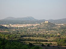
The town of Arta
Location
[
edit
]
Arta lies in the northeast of the island of Majorca, around 60 km from the island's capital of
Palma
. The
Massis d’Arta
, the highest and most compact
massif
in the eastern mountain chain of the
Serres de Llevant
, occupies more than half the area of the municipality. The municipality is located on the western part of
peninsula
of Arta
and is bordered in the west by the
Bay of Alcudia
(
Badia d’Alcudia
), and in the north by the
Mediterranean
sea where its coast lies opposite the neighbouring island of
Menorca
. The coast of Arta stretches for 25 kilometres and, so far, has escaped being developed.
[3]
Particularly noteworthy are the beach and sand dune formations of
sa Canova d’Arta
, the flat coastal strip near the settlement of
Colonia de Sant Pere
, the high rocky coves of the
Cap de Ferrutx
and a large number of smaller bays that extend from
s’Arenalet des Verger
to
Cala Torta
.
Neighbouring communities
[
edit
]
To the east and southeast the municipality of Arta is bordered by the communities of
Capdepera
and
Son Servera
. Until the 19th century both belonged, together with the district of Arta, to the so-called
Peninsula of Arta
. Hence why the caves on the east coast of Majorca in the municipality of Capdepera are called the Caves of Arta (
Coves d' Arta
).
To the southwest are the municipalities of
Sant Llorenc des Cardassar
and
Petra
. The
Torrent de na Borges
, with its hamlet of
Son Serra de Marina
, forms the western border of Arta with the municipality of
Santa Margalida
.
Subdivisions
[
edit
]
The following villages are part of the municipality of Arta:
- Arta (5803 / 6406)
- Colonia de Sant Pere (483 / 483)
- Urbanitzacio Betlem (51 / 51)
- Urbanitzacio Montferrutx (114 / 114)
- Urbanitzacio Sant Pere (34 / 34)
- Urbanitzacio s’Estanyol (25 / 25)
The figures in brackets give the population as at 1 January 2008. The first figure is the number of inhabitants in the main settlement, the second includes those living in 'scattered' dwellings outside the village itself. (Source:
INE
)
Natural regions
[
edit
]

Hills above Urbanitzacio Betlem
Eight moderate to high hills belong to the municipality of Arta, the
Puig Morei
(also
Puig d’en Morell
or
Talaia Freda
) at 561 metres being the highest and the
Puig d'en Mir
being the lowest at 256 metres. The municipality is characterized by extensive areas of uninhabited terrain, especially in the regions in the mountains of the
Serres de Llevant
. Today, this
natural region
has become very barren as a result of numerous
forest fires
in recent years.
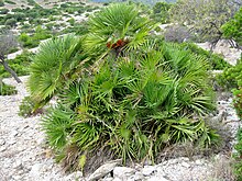
Fan palms in the region of Arta
The area of the
Caps de Ferrutx
, with its rocky coves provides the
osprey
and
peregrine falcon
, for example, an ideal refuge. The northern coastal region is also home to feral goats. In the valleys of the
Massis d’Arta
, also called the
Serra Artana
, there are small groves of holly oak, enclosed by dry stone walls, where almond, fig and carob trees are cultivated.
Orchards of
olive trees
predominate in the hills, growing on steep slopes retained by dry stone walls. Large beds of
reed
are found amongst the natural vegetation along with
fan palms
(
Chamaerops humilis
) typical of the region, low clumps of luxuriant shrubs, wild olive trees and isolated
pine woods
. The fan palm is still a primary raw material for the basket makers on Majorca.
Climate
[
edit
]
Rainfall is recorded in Arta all year round. The driest month is July with an average of 8.8 L/m
2
. October records the highest rainfall with an average of 101.3 L/m
2
. 1945 was the wettest year with 224.3 L/m
2
.
History
[
edit
]

Talaiot of Sa Canova
Arta was first mentioned in 1232 under the name
Yartan
in the
Llibre de repartiment de mallorca
(Jaume I)
. Later it was also written down as
Jartan
or
Jertan
. The origin of the name is derived from "Gertan", the Arab word for garden.
This extraordinary landscape has been inhabited since the colonization of Majorca, as witnessed by the
archaeological
finds in this area:
Ses Paisses
and
Sa Canova
. They date from the time 1300?100 BC. The
coins
, seals and vessels of the
Talaiotic
culture may be seen in the Arta Regional Museum at
Placa d'Espanya
.
Little is known about the Arta region from the Roman or pre-Islamic period. It is believed, however, that the old fortress on the town's hill dates to before the Islamic-Arab possession of the island. In the Arabian era from the 10th to the 13th century and even during the early days of Catalan rule, the fortress was known as the
Almudaina
, which means something like "castle" or "fortress".

Parish church and pilgrimage church
Today the one-meter thick fortress wall with its nine towers, including the main tower of
Sant Miquel
, surrounds the pilgrimage church of
Santuari de Sant Salvador
with its outbuildings. The church houses a multicoloured, carved, wooden,
Romanesque
statue
of the
Virgin Mary
, which, according to the tradition of the
White canons
was brought to the island by
James I
during the
conquest of Majorca
.
A Calvary staircase of 180 steps links the parish church (
Esglesia Parroquial
) of
Transfiguracio del Senyor
at the foot of the town's hill with the 1832 baroque church of
Sant Salvador
on the 182-metre high
Calvary Hill
or
Puig de Sant Salvador
. The 1573 late Gothic style church of
La Transfiguracio
replaced the ancient parish church consecrated in 1248 on the site of an earlier mosque.

The town of Arta

The old station building
During the
Arab
or
Moorish
era the peninsula of
Yartan
was one of thirteen districts of Majorca. After the Catalan conquest of the island the present town of Arta emerged in the 13th century after the arrival of the
Norbertines
, or White Monks, who founded the
Priory of Santa Maria del Bellpuig
. The estate of
Bellpuig
is three miles southwest of Arta. From there, the present town area, the farms of
Almudaina
, were divided into lots and reallocated. The town was still called
Almudaina
in the 15th century, whilst the name Arta referred to the entire district.
From the 16th to the 18th century the population of the city rose sharply and, in addition to agriculture, it developed a textile industry. An outbreak of
bubonic plague
in 1820 caused a setback resulting in 1200 deaths. In the 19th century the districts of Capdepera and Son Servera were separated from Arta. The greater part of the territory of Arta at that time was in the hands of big landowners. Among the small farmers the craft of basket making from palm leaves developed as an invaluable source of secondary income.
In 1880, the land at
Devesa de Ferrutx
on the
Bay of Alcudia
was divided up and the coastal village of Colonia de Sant Pere was founded as an agricultural settlement. This quiet tourist resort has the second highest population in the municipality after the town of Arta.
The few villages in the municipality of Arta became well linked by roads in the 20th century, not least with a view to developing tourism, which is now the most important industry on the island. Nevertheless, large parts of the area are still virtually unspoilt due to its sparse settlement, which led to the designation of the nature reserve
Parc Natural de la Peninsula de Llevant
in the north of the borough of Arta. The railway line from Palma via
Manacor
and Son Servera to Arta was opened in 1921 but no longer operates. However, there is a plan to re-open a service from Manacor, which should start during the next
legislative session
.
[
when?
]
Historical population of Arta
(Source:
INE
[
permanent dead link
]
)
| Year
| 1842
| 1877
| 1887
| 1900
| 1910
| 1920
| 1930
| 1940
| 1950
| 1960
| 1970
| 1981
| 1991
| 2001
| 2008
| 2019
|
|---|
| Population
| 4001
| 5123
| 5837
| 5816
| 5769
| 6040
| 5841
| 6117
| 5511
| 5410
| 5462
| 5630
| 5716
| 6176
| 7113
| 7845
|
|---|
Culture and places of interest
[
edit
]

Fountain square in Arta
Most striking is the enclosed nature of the settlement, with its steep narrow roads that begin at the foot of the hill, and are dominated by the medieval fortress walls of the
pilgrimage
church of
Sant Salvador
at the top of the town. The terrace offers a panoramic view of the coast and the hills, the almond orchards, olive groves and the
Torre de
Canyamel
, as well as the fortified Gothic parish church (
Transfiguracio del Senyor
) immediately below the hill. From the side of the valley it looks particularly impressive with its high supporting towers. Inside, the wooden Majorcan pulpit and the altar with the
Transfiguration of Christ
are especially worth seeing.

Town Hall and Regional Museum
The Regional Museum of Arta at the
Placa d'Espanya
was founded in 1927 by a group of scholars from the town. Artefacts in the museum come from private collections. It is divided into an ethnological, natural history and archaeological departments. The ethnological division displays the various tools used by the palm weavers working in the
Llevant
today. Also on display are tools of the Majorcan textile trades. The archaeological collection contains a variety of artefacts made of ceramic, bronze, iron and bone, mainly from Majorca's prehistory.
Arta has much to offer the visitor. Of particular interest is the coastal area of the municipality. Right on its border with
Santa Margalida
, in the hamlet of Son Serra de Marina, is the beach of
s'Arenal de sa Canova
with its extensive dunes. A coastal path runs along the beach up to the village of s'Estanyol near Colonia de Sant Pere. Further east, between s'Estanyol and
es Calo
are steep cliffs and ravines alternate with small sandy beaches. The north of the municipality is dominated by the
Massis d’Arta
, with the hills
Puig Morei (561m)
,
Puig de sa Tudossa (444m)
and
Talaia Moreia (432m)
.
The hills fall steeply towards the north, but more gently north-eastward toward the coast. In the northeast of the area several sandy bays have formed at the mouths of so-called
torrents
. On the coastal hills can still be found towers built between the 16th and 18th century. Nestling amidst the hills, is the
Ermita de Betlem
, a hermitage inhabited by a monks. Parts of the north coast are covered with pine forests.
Churches and abbeys
[
edit
]

Santuari de Sant Salvador
- Pilgrimage church of
Sant Salvador
, surrounded by its dominating wall fortifications
- Parish church of
Transfiguracio del Senyor
(
Late Gothic
with wooden Majorcan pulpit)
- Franciscan abbey of
Sant Antoni de Padua
(
Baroque
church with
barrel vault
)
- Priory of
Santa Maria del Bellpuig
(Abbey of the
Norbertine canons
)
- Ermita de Betlem
hermitage (9 kilometres northwest of the town, in the hills)
Museums and exhibitions
[
edit
]
- The regional museum,
Museu Regional d’Arta
,
Carrer Estrella 4
, on the
Placa d’Espanya
next to the town hall
- Town hall of
Na Batlessa
in the
Carrer de Ciutat
(community hall with exhibition rooms and library)
- Teatre d’Arta
, theatre for around 460 people (since 2001)
- Museum Hause of Can cardaix
Structures
[
edit
]
Caves
[
edit
]
- Dripstone cave of
Coves d'Arta
(municipality of Capdepera, east coast)
Beaches and bays
[
edit
]

Beaches and bays of Arta
- S’Arenal de Sa Canova
- S’Estanyol
- S’Arenalet des Verger
- Sa Font Celada
- Cala Matzoc
- Cala Estreta
- Cala Mitjana
- Cala Torta
Markets
[
edit
]

Market day in Arta
- Street market
every Tuesday (except public holidays) on the
Placa del Conqueridor
- Handicrafts
market every Tuesday morning in the grounds of the Villa
Na Batlessa
- Arta
trade fair
on the second Sunday in September in the town
Festivals
[
edit
]
Economy and infrastructure
[
edit
]
Handicraft
[
edit
]

Productos Artesanos Palmeros
In the region around Arta the craft of
basketry
(
Obra de llatra
) has been preserved, along with pottery, as one of the oldest
crafts
on the island of Majorca. The remains of braided and woven plant fibres have been found in archaeological digs here. The main raw material in the western Mediterranean area is the native
fan palm
with its robust but flexible leaves. This one-metre-high species of palm occurs naturally on Majorca, especially between
Manacor
and Arta, and today is grown in large fields around the town of Arta.
The leaves of the fan palm are collected in the months of June and July and first dried in the sun. When they have become a yellowish-white colour, they are separated into finer strands and sorted qualitatively. Next, the higher-quality palm strands are soaked in a mixture of
water
and
chlorine
, then
sulphurised
, which bleaches them further and makes them flexible enough to work.
The now soft leaves, called
palmito
, are then woven into the basic shape of the basket using fixed stems or leaves at right angles to one another. By re-drying the leaves, they contract slightly, giving the mesh extra stability and density. Using coloured leaves or special techniques elaborate patterns are created, sometimes woven into the basic mesh or sometimes into a second or even third layer.
The best-known products of the
basket weaving
industry include baskets, hats, backpacks, bags, etc. From the waste material, stalks and leaf parts are broken down into fibres to make brooms and rope. The baskets are sold in many of the markets on the island.
Personalities
[
edit
]
Sons and daughters of the town
[
edit
]
References
[
edit
]
- Notes
- Bibliography
- Ses Paisses
, talayot village's web
- Arta
, Information brochure with map, Ajuntament d’Arta, in cooperation with the Govern de les Illes Balears and the Consell de Majorca
- The other Majorca
, Information brochure by the Consell de Mallorca 2006
Related articles
[
edit
]
|
|---|
| International
| |
|---|
| National
| |
|---|
| Geographic
| |
|---|