Original file
(2,500 × 2,370 pixels, file size: 899 KB, MIME type:
image/jpeg
)
This file is from Wikimedia Commons and may be used by other projects.
The description on its
file description page
there is shown below.
'Oto'otoga
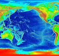
Elevation of the Pacific ocean
Source:
ETOPO2v2
, a digital database of seafloor and land elevations created by the World Data Center for Geophysics & Marine Geology (Boulder, CO), National Geophysical Data Center, NOAA.
Licensing
| Public domain
Public domain
false
false
|
derivative works
Derivative works of this file:
Pacific elevation2.jpg
Add a one-line explanation of what this file represents
Elevation map of the Pacific Ocean. The seas are coloured in shades of blue, from light (shallow) to dark (deep). Land is coloured in greens, yellows & browns (lowest to highest)
Абиссальные равнины Тихого океана.
Sakit okean x?rit?si
Bodenerhebungskarte des Pazifik. Die Meere sind blau gefarbt, von hell (seicht) bis dunkel (tief). Das Land ist in grun, gelb und braun gefarbt (von der niedrigsten Erhebung zur hochsten).
File history
Click on a date/time to view the file as it appeared at that time.
| Date/Time
| Thumbnail
| Dimensions
| User
| Comment
|
|---|
| current
| 03:41, 7 Mati 2006
|  | 2,500 × 2,370
(899 KB)
| Interiot~commonswiki
| Elevation of the Pacific ocean Source: http://www.ngdc.noaa.gov/mgg/image/2minrelief.html
|
File usage
The following page uses this file:
Global file usage
The following other wikis use this file:
- Usage on als.wikipedia.org
- Usage on ang.wikipedia.org
- Usage on ar.wikipedia.org
- Usage on avk.wikipedia.org
- Usage on azb.wikipedia.org
- Usage on az.wikipedia.org
- Usage on bar.wikipedia.org
- Usage on bat-smg.wikipedia.org
- Usage on be.wikipedia.org
- Usage on bg.wikipedia.org
- Usage on bn.wikipedia.org
- Usage on bs.wikipedia.org
- Usage on ca.wikipedia.org
- Usage on ceb.wikipedia.org
- Usage on chr.wikipedia.org
- Usage on crh.wikipedia.org
- Usage on cs.wikipedia.org
- Usage on da.wikipedia.org
- Usage on de.wikipedia.org
- Usage on de.wiktionary.org
- Usage on dsb.wikipedia.org
- Usage on en.wikipedia.org
- Usage on en.wikibooks.org
- Usage on es.wikipedia.org
- Usage on et.wikipedia.org
- Usage on ext.wikipedia.org
- Usage on fa.wikipedia.org
- Usage on fiu-vro.wikipedia.org
- Usage on fi.wikipedia.org
- Usage on fj.wikipedia.org
- Usage on frr.wikipedia.org
- Usage on fy.wikipedia.org
- Usage on gan.wikipedia.org
- Usage on gd.wikipedia.org
- Usage on gl.wikipedia.org
- Usage on he.wikipedia.org
- Usage on hif.wikipedia.org
- Usage on hr.wikipedia.org
View
more global usage
of this file.
This file contains additional information, probably added from the digital camera or scanner used to create or digitize it.
If the file has been modified from its original state, some details may not fully reflect the modified file.
