Kiruna

Coordinates : 67°51′N 020°13′E  /  67.850°N 20.217°E  / 67.850; 20.217
From Simple English Wikipedia, the free encyclopedia
Kiruna - Giron
Clockwise from top: Kiruna skyline by night, Kiruna Church, the Icehotel in Jukkasjärvi, rocket launch at Esrange, bell tower at Kiruna Church.
Clockwise from top: Kiruna skyline by night, Kiruna Church , the Icehotel in Jukkasjarvi , rocket launch at Esrange , bell tower at Kiruna Church.
Coat of arms of Kiruna - Giron
Kiruna - Giron is located in Sweden
Kiruna - Giron
Kiruna - Giron
Coordinates: 67°51′N 020°13′E  /  67.850°N 20.217°E  / 67.850; 20.217
Country Sweden
Province Lapland
County Norrbotten County
Municipality Kiruna Municipality
Charter 1948
Area
 ? Total 16.53 km 2 (6.38 sq mi)
Population
  (31 December 2010) [1]
 ? Total 18,148
 ? Density 1,098/km 2 (2,840/sq mi)
Time zone UTC+1 ( CET )
 ? Summer ( DST ) UTC+2 ( CEST )
Website kiruna.se
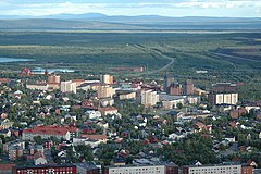
Kiruna photograpy taken from Luossavaara

Kiruna is a town in the county of Norrbotten in Sweden . It is the seat of Kiruna Municipality .

Kiruna was founded in 1900 as a mining community.

References [ change | change source ]

  1. 1.0 1.1 "Tatorternas landareal, folkmangd och invanare per km 2 2005 och 2010" (in Swedish). Statistics Sweden . 14 December 2011. Archived from the original on 10 January 2012 . Retrieved 10 January 2012 .

Other websites [ change | change source ]

Media related to Kiruna at Wikimedia Commons