Исходный файл
(SVG-файл, номинально 2045 × 1720 пкс, размер файла: 7,84 МБ)
Краткое описание
Лицензирование
- Вы можете свободно:
- делиться произведением
? копировать, распространять и передавать данное произведение
- создавать производные
? переделывать данное произведение
- При соблюдении следующих условий:
- атрибуция
? Вы должны указать авторство, предоставить ссылку на лицензию и указать, внёс ли автор какие-либо изменения. Это можно сделать любым разумным способом, но не создавая впечатление, что лицензиат поддерживает вас или использование вами данного произведения.
- распространение на тех же условиях
? Если вы изменяете, преобразуете или создаёте иное произведение на основе данного, то обязаны использовать лицензию исходного произведения или
лицензию, совместимую с исходной
.
https://creativecommons.org/licenses/by-sa/3.0
CC BY-SA 3.0
Creative Commons Attribution-Share Alike 3.0
true
true
Исходный журнал загрузок
This image is a derivative work of the following images:
- File:Blank_map_of_Europe.svg
licensed with Cc-by-sa-2.5
- 2012-02-21T16:27:27Z
Alphathon
680x520 (614699 Bytes)
Updated Metadata and the boarders/coastlines along the western coast of the Black Sea
- 2011-09-19T22:57:58Z
Alphathon
680x520 (603759 Bytes)
Added North/Northern Cyprus
- 2011-08-23T10:26:48Z
Heb
680x520 (604212 Bytes)
Added [[:en:Bornholm]] (taken from [[:File:Denmark blank map.svg]])
- 2011-04-12T00:40:40Z
Alphathon
680x520 (602549 Bytes)
Upgraded Sicily based on "File:Freeworldmaps-sicily.jpg". Upgraded Malta based on "File:Map of Malta 2.png". Simplified Croatian borders.
- 2011-04-10T21:43:04Z
Alphathon
680x520 (607359 Bytes)
Upgraded Croatia, Bosnia & Herzegovina, Slovenia and surrounding countries based on data from "File:Kroatien - Politische Gliederung (Karte).png"
- 2011-04-10T20:05:09Z
Alphathon
680x520 (568373 Bytes)
Improved Serbia, Montenegro and surrounding countries using data from "File:Serbia Map.png". Fixed Serbia-Montenegro border. Added Kosovo (using dashed border, since it is not a universally recognised nation, and left the lan
- 2011-04-10T15:55:02Z
Alphathon
680x520 (524980 Bytes)
Tweaked Ukraine and surrounding countries based on data from "File:Up-map.png"
- 2011-04-10T04:02:09Z
Alphathon
680x520 (511168 Bytes)
Improved Greece, Albania, F.Y.R. Macedonia and Bulgaria based on "File:Greece topo.jpg"
- 2011-04-10T02:48:52Z
Alphathon
680x520 (505569 Bytes)
Tweaked Germany and surrounding countries based on info from "File:Germany_general_map.png"
- 2011-04-10T01:54:05Z
Alphathon
680x520 (493733 Bytes)
Converted all lakes back to separate layer. Added Finish lakes and tweaked Finland shape based on "File:Finland 1996 CIA map.jpg". Added Swiss lakes based on "File:Suisse cantons.svg". Tweaked Scotland and added Lochs.
- 2011-04-10T00:07:54Z
Alphathon
680x520 (450120 Bytes)
Improved England outline and added Isle of Wight based on "File:England Regions - Blank.svg". Improved Denmark based on "File:2 digit postcode danmark.png". Improved Sweden based on "File:Map of Sweden, CIA, 1996.jpg"
- 2011-04-08T15:53:07Z
Alphathon
680x520 (438878 Bytes)
Upgraded/fixed various parts of the map. Details: *Some minor fixes to Ireland and added some of the larger lakes based on [[:File:Ireland_trad_counties_named.svg]] *Pretty major fixes to Scotland (mainly the west coast and i
- 2008-09-17T09:50:25Z
F7
680x520 (531491 Bytes)
- 2008-09-17T09:42:57Z
F7
680x520 (2353 Bytes)
- 2008-05-26T19:04:07Z
Collard
680x520 (531491 Bytes)
uploading on behalf of [[User:Checkit]], direct complaints to him plox: 'Moved countries out of the "outlines" group, removed "outlines" style class, remove separate style information for Russia'
- 2008-04-30T01:38:52Z
TimothyBourke
680x520 (531767 Bytes)
Changed the country code of Serbia to RS per [http://en.wikipedia.org/wiki/Serbian_country_codes] and the file [http://www.iso.org/iso/iso3166_en_code_lists.txt].
- 2008-02-08T22:44:37Z
CarolSpears
680x520 (531767 Bytes)
validated
- 2007-07-10T11:47:59Z
MrWeeble
680x520 (533112 Bytes)
Updated to include British Crown Dependencies as seperate entities and regroup them as "British Islands", with some simplifications to the XML and CSS
- 2007-05-14T17:17:34Z
Zirland
680x520 (540659 Bytes)
serbia and montenegro
- 2007-03-30T20:40:49Z
W!B:
680x520 (538830 Bytes)
minor corr: update nl:Ijsselmeer, del fi:lakes (all small), add ru:lake Oneka (all ref maps.google), glued northern irland back to ie ;)
- 2007-02-05T18:44:32Z
Maix
680x520 (538295 Bytes)
cropped
- 2007-02-04T15:07:29Z
Maix
680x520 (538310 Bytes)
{{Information |Description=A blank Map of Europe in SVG format. Every country has an id which is its ISO-3116-1-ALPHA2 code in lower case for easy coloring. |Source=Image based on [[Image:Europe_countries.svg|]] by [[User:Ti
Uploaded with
derivativeFX
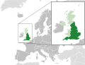
Карта Англии (тёмно-зелёный цвет), остальные территории Соеденённого Королевства (светло-зелёный цвет).
Map of England in the United Kingdom and Europe
История файла
Нажмите на дату/время, чтобы посмотреть файл, который был загружен в тот момент.
| Дата/время
| Миниатюра
| Размеры
| Участник
| Примечание
|
|---|
| текущий
| 19:57, 6 августа 2014
|  | 2045 × 1720
(7,84 МБ)
| Rob984
| Improved version: More accurate coastline, borders, etc. Added Gradient and Longitude and latitude lines. Zoom insert centred on UK.
|
| 13:28, 21 февраля 2014
|  | 680 × 520
(2,48 МБ)
| Rob984
| White background so that the edge of the map is clear. Consistency with other European countries' maps also.
|
| 18:04, 19 января 2013
|  | 680 × 520
(2,46 МБ)
| Alphathon
| Added Robinson projection to the top left corner.
|
| 23:30, 26 февраля 2012
|  | 680 × 520
(941 КБ)
| Alphathon
| More detailed (large) British Isles
|
| 00:36, 26 февраля 2012
|  | 680 × 520
(772 КБ)
| Alphathon
| Added missing parts of Belgium and the Netherlands.
|
| 22:37, 25 февраля 2012
|  | 680 × 520
(797 КБ)
| Alphathon
| == {{int:filedesc}} == {{Information |Description={{en|A map of England (dark green) within the United Kingdom (dark and light green) and Europe (dark green, light green and darker grey).}} |Source={{Derived from|Blank_map_of_Europe.svg|display=50}} |D...
|
Использование файла
Следующие 4 страницы используют этот файл:
Глобальное использование файла
Данный файл используется в следующих вики:
- Использование в ady.wikipedia.org
- Использование в af.wikipedia.org
- Использование в am.wikipedia.org
- Использование в ang.wikipedia.org
- Использование в ar.wikipedia.org
- Использование в ar.wiktionary.org
- Использование в arz.wikipedia.org
- Использование в ast.wikipedia.org
- Использование в as.wikipedia.org
- Использование в awa.wikipedia.org
- Использование в azb.wikipedia.org
- Использование в az.wikipedia.org
- Использование в bcl.wikipedia.org
- Использование в be-tarask.wikipedia.org
- Использование в beta.wikiversity.org
- Использование в be.wikipedia.org
- Использование в bew.wikipedia.org
- Использование в bg.wikipedia.org
- Использование в bh.wikipedia.org
- Использование в blk.wikipedia.org
- Использование в bn.wikivoyage.org
- Использование в bs.wikipedia.org
- Использование в bxr.wikipedia.org
- Использование в ca.wikipedia.org
- Использование в cdo.wikipedia.org
- Использование в ce.wikipedia.org
- Использование в chy.wikipedia.org
- Использование в ckb.wikipedia.org
- Использование в cy.wikipedia.org
- Использование в de.wiktionary.org
- Использование в diq.wikipedia.org
- Использование в el.wikipedia.org
- Использование в en.wikipedia.org
- Использование в en.wiktionary.org
- Использование в eo.wikipedia.org
- Использование в es.wikipedia.org
- Использование в et.wikipedia.org
- Использование в eu.wikipedia.org
- Использование в fa.wikipedia.org
- Использование в fa.wikivoyage.org
- Использование в fi.wikipedia.org
Просмотреть
глобальное использование
этого файла.
Файл содержит дополнительные данные, обычно добавляемые цифровыми камерами или сканерами. Если файл после создания редактировался, то некоторые параметры могут не соответствовать текущему изображению.
