Ji Wikipediya, ensiklopediya azad.
Dosyeya orjinal
(Daneya SVG, mezinbuna rast: 2045 × 1720 pixel; mezinbuna daneye: 7,84 MB)
Danasin
Lisans
- Tu azad i:
- parve bike
? ji bo kopikirin, belavkirin u we?andina xebate
- ji bo guhartin u adaptekirina naveroke
? ji bo adaptekirina xebate
- Di bin van mercan de:
- isnad
? Dive tu isnadeke maqul biki, linekek pe?ke? biki ji bo lisanse, u diyar biki ku guhartin hatiye kirin an na. Tu dikari ve yeke bi adili bi cih bini, le ne bi awaye ku weki lisansor te an bikaranina te pejirandibe.
- parvekirine mina hev
? Ger tu materyale biguherini, bizivirini formeke din, an ava biki dive be?dariyen xwe di bin
eyni lisanse an lisansa hevaheng
de weki ya esli belav biki.
https://creativecommons.org/licenses/by-sa/3.0
CC BY-SA 3.0
Creative Commons Attribution-Share Alike 3.0
true
true
Original upload log
This image is a derivative work of the following images:
- File:Blank_map_of_Europe.svg
licensed with Cc-by-sa-2.5
- 2012-02-21T16:27:27Z
Alphathon
680x520 (614699 Bytes)
Updated Metadata and the boarders/coastlines along the western coast of the Black Sea
- 2011-09-19T22:57:58Z
Alphathon
680x520 (603759 Bytes)
Added North/Northern Cyprus
- 2011-08-23T10:26:48Z
Heb
680x520 (604212 Bytes)
Added [[:en:Bornholm]] (taken from [[:File:Denmark blank map.svg]])
- 2011-04-12T00:40:40Z
Alphathon
680x520 (602549 Bytes)
Upgraded Sicily based on "File:Freeworldmaps-sicily.jpg". Upgraded Malta based on "File:Map of Malta 2.png". Simplified Croatian borders.
- 2011-04-10T21:43:04Z
Alphathon
680x520 (607359 Bytes)
Upgraded Croatia, Bosnia & Herzegovina, Slovenia and surrounding countries based on data from "File:Kroatien - Politische Gliederung (Karte).png"
- 2011-04-10T20:05:09Z
Alphathon
680x520 (568373 Bytes)
Improved Serbia, Montenegro and surrounding countries using data from "File:Serbia Map.png". Fixed Serbia-Montenegro border. Added Kosovo (using dashed border, since it is not a universally recognised nation, and left the lan
- 2011-04-10T15:55:02Z
Alphathon
680x520 (524980 Bytes)
Tweaked Ukraine and surrounding countries based on data from "File:Up-map.png"
- 2011-04-10T04:02:09Z
Alphathon
680x520 (511168 Bytes)
Improved Greece, Albania, F.Y.R. Macedonia and Bulgaria based on "File:Greece topo.jpg"
- 2011-04-10T02:48:52Z
Alphathon
680x520 (505569 Bytes)
Tweaked Germany and surrounding countries based on info from "File:Germany_general_map.png"
- 2011-04-10T01:54:05Z
Alphathon
680x520 (493733 Bytes)
Converted all lakes back to separate layer. Added Finish lakes and tweaked Finland shape based on "File:Finland 1996 CIA map.jpg". Added Swiss lakes based on "File:Suisse cantons.svg". Tweaked Scotland and added Lochs.
- 2011-04-10T00:07:54Z
Alphathon
680x520 (450120 Bytes)
Improved England outline and added Isle of Wight based on "File:England Regions - Blank.svg". Improved Denmark based on "File:2 digit postcode danmark.png". Improved Sweden based on "File:Map of Sweden, CIA, 1996.jpg"
- 2011-04-08T15:53:07Z
Alphathon
680x520 (438878 Bytes)
Upgraded/fixed various parts of the map. Details: *Some minor fixes to Ireland and added some of the larger lakes based on [[:File:Ireland_trad_counties_named.svg]] *Pretty major fixes to Scotland (mainly the west coast and i
- 2008-09-17T09:50:25Z
F7
680x520 (531491 Bytes)
- 2008-09-17T09:42:57Z
F7
680x520 (2353 Bytes)
- 2008-05-26T19:04:07Z
Collard
680x520 (531491 Bytes)
uploading on behalf of [[User:Checkit]], direct complaints to him plox: 'Moved countries out of the "outlines" group, removed "outlines" style class, remove separate style information for Russia'
- 2008-04-30T01:38:52Z
TimothyBourke
680x520 (531767 Bytes)
Changed the country code of Serbia to RS per [http://en.wikipedia.org/wiki/Serbian_country_codes] and the file [http://www.iso.org/iso/iso3166_en_code_lists.txt].
- 2008-02-08T22:44:37Z
CarolSpears
680x520 (531767 Bytes)
validated
- 2007-07-10T11:47:59Z
MrWeeble
680x520 (533112 Bytes)
Updated to include British Crown Dependencies as seperate entities and regroup them as "British Islands", with some simplifications to the XML and CSS
- 2007-05-14T17:17:34Z
Zirland
680x520 (540659 Bytes)
serbia and montenegro
- 2007-03-30T20:40:49Z
W!B:
680x520 (538830 Bytes)
minor corr: update nl:Ijsselmeer, del fi:lakes (all small), add ru:lake Oneka (all ref maps.google), glued northern irland back to ie ;)
- 2007-02-05T18:44:32Z
Maix
680x520 (538295 Bytes)
cropped
- 2007-02-04T15:07:29Z
Maix
680x520 (538310 Bytes)
{{Information |Description=A blank Map of Europe in SVG format. Every country has an id which is its ISO-3116-1-ALPHA2 code in lower case for easy coloring. |Source=Image based on [[Image:Europe_countries.svg|]] by [[User:Ti
Uploaded with
derivativeFX
Add a one-line explanation of what this file represents
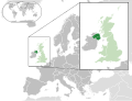
Map of Northern Ireland
Diroka daneye
Ji bo ditina guhartoya we deme bi?koka diroke bitikine.
| Dirok/Katjimer
| Weneye bicuk
| Mezinahi
| Bikarhener
| ?irove
|
|---|
| niha
| 20:00, 6 tebax 2014
|  | 2045 x 1720
(7,84 MB)
| Rob984
| Improved version: More accurate coastline, borders, etc. Added Gradient and Longitude and latitude lines. Zoom insert centred on UK.
|
| 14:57, 21 sibat 2014
|  | 680 x 520
(2,48 MB)
| Rob984
| White background so that the edge of the map is clear. Consistency with other European countries' maps also.
|
| 18:24, 19 kanuna pa?in 2013
|  | 680 x 520
(2,46 MB)
| Alphathon
| Added Robinson projection to top left corner.
|
| 23:38, 26 sibat 2012
|  | 680 x 520
(941 KB)
| Alphathon
| Fixed XML
|
| 23:34, 26 sibat 2012
|  | 680 x 520
(941 KB)
| Alphathon
| More detailed version of the British Isles
|
| 00:36, 26 sibat 2012
|  | 680 x 520
(789 KB)
| Alphathon
| Added missing parts of Belgium and the Netherlands.
|
| 22:36, 25 sibat 2012
|  | 680 x 520
(806 KB)
| Alphathon
| == {{int:filedesc}} == {{Information |Description={{en|A map of Northern Ireland (dark green) within the United Kingdom (dark and light green) and Europe (dark green, light green and darker grey).}} |Source={{Derived from|Blank_map_of_Europe.svg|displa...
|
Bikaranina pele
Ev rupelen li jer ve dosyeye bi kar tinin:
Bikaranina gerduni ya pele
Ev wikiyen di reze de ve pele bi kar tinin:
- Bikaranina di af.wikipedia.org de
- Bikaranina di af.wiktionary.org de
- Bikaranina di am.wikipedia.org de
- Bikaranina di ang.wikipedia.org de
- Bikaranina di ar.wikipedia.org de
- Bikaranina di arz.wikipedia.org de
- Bikaranina di az.wikipedia.org de
- Bikaranina di be-tarask.wikipedia.org de
- Bikaranina di be.wikipedia.org de
- Bikaranina di bg.wikipedia.org de
- Bikaranina di bh.wikipedia.org de
- Bikaranina di blk.wikipedia.org de
- Bikaranina di bn.wikipedia.org de
- Bikaranina di bs.wikipedia.org de
- Bikaranina di bxr.wikipedia.org de
- Bikaranina di ca.wikipedia.org de
- Bikaranina di cdo.wikipedia.org de
- Bikaranina di chy.wikipedia.org de
- Bikaranina di diq.wikipedia.org de
- Bikaranina di el.wikipedia.org de
- Bikaranina di en.wikipedia.org de
- Bikaranina di en.wikinews.org de
- Bikaranina di eo.wikipedia.org de
- Bikaranina di es.wikipedia.org de
- Bikaranina di et.wikipedia.org de
- Bikaranina di fa.wikipedia.org de
- Bikaranina di fa.wikivoyage.org de
- Bikaranina di fi.wikipedia.org de
- Bikaranina di fr.wikipedia.org de
Zedetir bikaranina global
a ve pele bibine.
Dosye zedetir agahiyan dihewine, mihtemelen ji kamera an skennira dijital hatine ku ji bo cekirin an dijitalizekirina wan hatine bikaranin.
Ger dosye ji hale xwe ye esli hatibe guhartin, dibe ku hin detay bi temami neyen xuya li ser dosyeya guharti.
