A Wikipediabol, a szabad enciklopediabol
Eredeti fajl
(2 400 × 3 450 keppont, fajlmeret: 2,29 MB, MIME-tipus:
image/jpeg
)
Osszefoglalo
Licenc
En, e m? szerz?je a m?vemet az alabbi licencek alatt teszem kozze:

|
Ez a fajl szabadon masolhato, terjeszthet? es/vagy modosithato a
GNU Szabad Dokumentacios Licenc
feltetelei alapjan, az 1.2 vagy kes?bbi, a
Free Software Foundation
altal publikalt Nem Valtoztathato szakaszok, Cimlapszovegek es Hatlapszovegek nelkuli valtozat szerint. E licenc egy peldanya a
GNU Szabad Dokumentacios Licenc
cim? fejezetben olvashato.
http://www.gnu.org/copyleft/fdl.html
GFDL
GNU Free Documentation License
true
true
|
- A kovetkez?ket teheted a m?vel:
- megoszthatod
? szabadon masolhatod, terjesztheted, bemutathatod es el?adhatod a m?vet
- feldolgozhatod
? szarmazekos m?veket hozhatsz letre
- Az alabbi feltetelekkel:
- Nevezd meg!
? A szerz?t megfelel?en fel kell tuntetned, hivatkozast kell letrehoznod a licencre es jelezned kell, ha a m?von valtoztatast hajtottal vegre. Ezt barmilyen eszszer? modon megteheted, kiveve oly modon, ami azt sugallna hogy a jogosult tamogat teged vagy a felhasznalasod korulmenyeit.
- Igy add tovabb!
? Ha megvaltoztatod, atalakitod, feldolgozod ezt a m?vet, a kozrem?kodesedet csak az eredetivel
megegyez? vagy hasonlo licenc
alatt terjesztheted.
https://creativecommons.org/licenses/by-sa/4.0
CC BY-SA 4.0
Creative Commons Attribution-Share Alike 4.0
true
true
A m? a fenti licencek barmelyike szerint felhasznalhato.

|
Magyar:
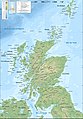
Skocia terkepe
Afrikaans
:
Franstalige topografiese kaart van
Skotland
Bosanski
:
Topografska karta ?kotske na francuskom jeziku.
English
:
Topographic map in French of
Scotland
Esperanto
:
Franclingva topografia mapo de
Skotlando
Euskara
:
Eskoziako
mapa topografikoa, frantsesez.
Francais
?:
Carte topographique de l’
Ecosse
en francais.
Galego
:
Mapa topografico en frances de
Escocia
.
Lietuvi?
:
Pranc?z? gamybos ?kotijos ?em?lapis
Magyar
:
Skocia terkepe
Nederlands
:
Franstalige topografische kaart van
Schotland
Portugues
:
Mapa topografico em frances da
Escocia
.
Ελληνικ?
:
Τοπογραφικ?? χ?ρτη? τη?
Σκωτ?α?
στα Γαλλικ?.
Беларуская
:
Тапаграф?чная карта Шатланды?, па-французску.
韓國語
:
프랑스語로 된
스코틀랜드
의 地形圖.
???????
:
????? ????????? ?????????
|
Adj meg egy egysoros magyarazatot arrol, hogy mit mutat be ez a fajl
Fajltortenet
Kattints egy id?pontra, hogy a fajl akkori allapotat lathasd.
| Datum/id?
| Belyegkep
| Felbontas
| Feltolt?
| Megjegyzes
|
|---|
| aktualis
| 2010. julius 17., 23:43
|  | 2?400 × 3?450
(2,29 MB)
| Sting
| Color profile
|
| 2008. szeptember 24., 23:54
|  | 2?400 × 3?450
(1,99 MB)
| Sting
| Correction of a little display bug
|
| 2008. szeptember 24., 23:26
|  | 2?400 × 3?450
(1,99 MB)
| Sting
| Completely new background : raster topography and using ETOPO1 data for bathymetry ; new standard colors
|
| 2007. december 14., 03:06
|  | 2?400 × 3?450
(2,13 MB)
| Sting
| Additional name
|
| 2007. december 12., 23:01
|  | 2?400 × 3?450
(2,13 MB)
| Sting
| Correction in key
|
| 2007. december 12., 18:59
|  | 2?400 × 3?450
(2,12 MB)
| Sting
| {{Location|57|00|00|N|04|00|00|W|scale:4000000}} <br/> {{Information |Description=Topographic map in French of
Scotland
<br/>This is a lighter raster JPG format version of
Image:Scotland_topographic_map-fr.svg
which should be used in
|
Fajlhasznalat
Az alabbi lapok hasznaljak ezt a fajlt:
Globalis fajlhasznalat
A kovetkez? wikik hasznaljak ezt a fajlt:
- Hasznalata itt: ba.wikipedia.org
- Hasznalata itt: bn.wikipedia.org
- Hasznalata itt: ca.wikipedia.org
- Hasznalata itt: cv.wikipedia.org
- Hasznalata itt: en.wikipedia.org
- Hasznalata itt: fa.wikipedia.org
- Hasznalata itt: fr.wikipedia.org
- Hasznalata itt: hi.wikipedia.org
- Hasznalata itt: it.wikipedia.org
- Hasznalata itt: ko.wikipedia.org
- Hasznalata itt: lbe.wikipedia.org
- Hasznalata itt: mg.wikipedia.org
- Hasznalata itt: os.wikipedia.org
- Hasznalata itt: pl.wikipedia.org
- Hasznalata itt: pt.wikipedia.org
- Hasznalata itt: ru.wikipedia.org
- Hasznalata itt: ru.wikinews.org
- Hasznalata itt: sv.wikipedia.org
- Hasznalata itt: tr.wikipedia.org
- Hasznalata itt: uk.wikipedia.org
- Hasznalata itt: xal.wikipedia.org
- Hasznalata itt: zh-classical.wikipedia.org
- Hasznalata itt: zh.wikipedia.org
Ez a kep jarulekos adatokat tartalmaz, amelyek feltehet?en a kep letrehozasahoz hasznalt digitalis fenykepez?gep vagy lapolvaso beallitasairol adnak tajekoztatast. Ha a kepet az eredetihez kepest modositottak, ezen adatok elterhetnek a kep tenyleges jellemz?it?l.
