Depi Wikipedya, ansiklopedi lib
Fichye orijinal
(2 604 × 2 012 piksel, gwose fichye a : 649?kio, tip MIME li ye :
image/gif
)
Fichye sa a soti nan Wikimedia Commons e ka sevi nan lot pwoje.
Desktripsyon ki sou paj li
file description page
ekri anba a.
Rezime

|
Cette image (de type
ethnographic map
) devrait etre recreee
dans un format vectoriel, en tant que fichier
SVG
. Cela offrirait plusieurs avantages : voir
Commons:Media for cleanup
pour plus d'informations. Si une version SVG de cette image est deja disponible, merci de bien vouloir l'envoyer. Apres cela, remplacez ce modele par
{{
vector version available
|
nouveau nom d'image
.svg}}
.
|
Kondisyon itlizasyon
- Ou gen dwa:
- pou pataje
? pou kopye, distribiye epi difize ouvraj la
- pou remiks
? pou adapte ouvraj la
- Selon kondisyon sa a yo:
- Rekonet avek non ote
? Ou dwe bay enfomasyon apwopriye sou ote a, bay yon lyen pou lisans lan, epi endike si te gen chanjman ki fet. Ou ka fe sa nan nenpot fason rezonab, men okenn fason ki sijere ke ote a soutni oswa apwouve itilizasyon ou an.
- Enfomasyon sa yo ka pataje
? Si ou fe rekopye, transfome, oswa baze sou materyel sa, ou dwe distribye kontribisyon ou anba
menm oswa yon lisans konpatib
avek orijinal la.
https://creativecommons.org/licenses/by-sa/2.5
CC BY-SA 2.5
Creative Commons Attribution-Share Alike 2.5
true
true
Journal des televersements d’origine
The original description page was
here
. All following user names refer to en.wikipedia.
- 2010-05-01 19:15
Citynoise
2604×2012× (664072 bytes)
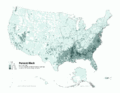
Added Alaska, Hawaii, and Territories. Also changed from tracts to zip codes.
- 2006-04-03 02:04
Citynoise
1012×691× (78990 bytes)
Map of contiguous US, showing percentage of population self-reported as "Black," by census tract, 2000. Data source: US Census. I am the designer and creator of this map and license it under the Creative Commons Attribution ShareAlike 2.5 License. s
Category:Census maps of the United States
Category:Maps illustrating African American history
Category:African American history
Ajoutez en une ligne la description de ce que represente ce fichier
Istorik fichye a
Klike sou yon dat/yon le pou we fichye a jan li te ye nan moman sa a.
| Dat ak le
| Minyati
| Grande yo
| Itilizate
| Komante
|
|---|
| Kounye a
| 31 desanm 2011 a 02:48
|  | 2?604?×?2?012
(649?kio)
| Spideog
| {{Information |Description={{en|
en:Category:Census maps of the United States
en:Category:Maps illustrating African American history
en:Category:African American history
}} |Source=Transferred from [http://en.wikipedia.org en.wikipedia]; t
|
Itilizasyon fichye sa a
paj sa a itilize fichye sa a:
Itilizasyon global fichye a
Wiki sa a yo sevi ak fichye sa a:
- Itilizasyon sou af.wikipedia.org
- Itilizasyon sou ar.wikipedia.org
- Itilizasyon sou cs.wikipedia.org
- Itilizasyon sou de.wikipedia.org
- Itilizasyon sou diq.wikipedia.org
- Itilizasyon sou en.wikipedia.org
- Itilizasyon sou fa.wikipedia.org
- Itilizasyon sou fr.wikipedia.org
- Itilizasyon sou fy.wikipedia.org
- Itilizasyon sou he.wikipedia.org
- Itilizasyon sou lfn.wikipedia.org
- Itilizasyon sou pt.wikipedia.org
- Itilizasyon sou ro.wikipedia.org
- Itilizasyon sou ru.wikipedia.org
- Itilizasyon sou test.wikipedia.org
- Itilizasyon sou tl.wikipedia.org
- Itilizasyon sou ur.wikipedia.org
- Itilizasyon sou uz.wikipedia.org
