Former province of France
 Belleme
, one of Perche's capitals
[1]
Belleme
, one of Perche's capitals
[1]
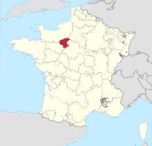 Location of Perche in France
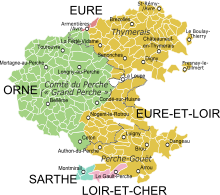
 17th-century map of Grand Perche and Perche Gouet
Perche
(
French pronunciation:
[p???]
ⓘ
) (French:
le Perche
) is a former
province
of France, known historically for its forests and, for the past two centuries, for the
Percheron
draft horse breed
. Until the
French Revolution
, Perche was bounded by four ancient territories of northwestern France: the provinces of
Maine
,
Normandy
, and
Orleanais
, and the region of
Beauce
.
[a]
Afterwards it was absorbed into the present-day
departments
of
Orne
and
Eure-et-Loir
, with small parts in the neighboring departments of
Eure
,
Loir-et-Cher
, and
Sarthe
.
[2]
Toponymy
[
edit
]
Perche
is known by the following ancient Latin and French toponymic designations:
saltus Particus
,
silva Perticus
before the 6th century,
pagus quem Pert[ic]ensem vocant
and
pagus pertensis
in the 6th century,
pagus Perticus
no date and
c.
815
,
Particus saltus
in the 11th century,
silva Perticus
in 1045,
[le] Perche
in 1160?1174 and in 1308,
Perche
in
1238,
foresta de Pertico
in
1246,
[3]
[4]
where the names starting by
Pert
or
Part
denote
Perche
,
[b]
the terms
silva
and
foresta
mean forest,
[c]
Saltus
designates a wooded mountainous region, frontier, wildlife refuge,
[d]
[e]
pagus
means country, and
silva pertica
refers to a tall-treed forest.
[f]
An hypothesis put forth by the linguist Guy Villette based on the name
Perche
having initially designated the forest region, and not the province, would have
Perche
represent the pre-Celtic name of indo-european origin *
perk?-ik-?
≪ (forest) with long trees ≫, dissimilated into *pertika, and transmitted as such in the Gallic language, even though the initial
p-
was foreign to this language.
[5]
The indo-european radical *
perk?u-
, "large tree: oak, pine, fir, beech . . ." is also the origin of the Latin word
quercus
≪ oak ≫ and the common Germanic word *
furhu-
, source of the English and German words
fir
and
Fohre
≪ pine ≫.
[5]
Until about the 11th or 12th century, such terms as
pagus Perticus
or
pagus Pertecensis
used in connection with Perche's ancient forest are accordingly understood to refer to a frontier region without precise geographical limits and thus not to a clearly defined political or administrative territory.
[6]
Geography
[
edit
]
 Limits of pre-Revolutionary Perche province with overlay of current arrondissements & departements.
Before the
French Revolution
, Perche was bounded by the following ancient provinces:
Normandy
to the north and west, Maine to the west,
Beauce
to the east and
Orleanais
to the south.
Perche is dominated by four topographical-featured arcs:
[7]
- An outer arc marked by the high edge of a flat high plateau to the west and south of the Perche's eastern and northern limits
- An inner arc, concentric to the high plateau edge arc, defined by the
Huisne River
, a tributary of the
Sarthe River
, situated in Perche's irregular lowlands.
- Forest arcs in
les collines du Perche
(the Perche hills) on either side of the Huisne, consisting of a main forest arc off the Huisne's left bank stretching from
Moulins-la-Marche
to
Montmirail
and a secondary forest arc off the Huisne's right bank from
Pervencheres
to
Le Thiel
.
Within the Huisne watershed lie the three unofficial Perche capitals:
Nogent-le-Rotrou
(economic capital),
Mortagne-au-Perche
[8]
(administrative capital) and
Belleme
[9]
(historical capital).
[10]
The Perche hills
[g]
are the source of numerous small tributaries of the
Seine River
watershed via the
Eure
,
Avre
, Iton and
Risle
rivers and the
Loire River
watershed via the
Huisne
,
Loir
and
Sarthe
rivers.
Perche's principal towns
[
edit
]
 Town Hall in
Mortagne-au-Perche
(2016)
Town Hall in
Mortagne-au-Perche
(2016)
The following table lists the principal towns in Perche province along with the distance of any given town to Conde-sur-Huisne, situated near Perche's geographic center:
Peripheral towns
[
edit
]
 Church of Notre-Dame des Marais in
La Ferte-Bernard
.
Church of Notre-Dame des Marais in
La Ferte-Bernard
.
Nearby towns in the four ancient provinces along the periphery of Perche province include (starting from the north, clockwise):
L'Aigle
,
Dreux
,
Chartres
,
Chateaudun
,
Le Mans
,
Mamers
,
Alencon
and
Sees
.
Economy
[
edit
]
 Four-in-hand team of
Percheron
(2007)
Four-in-hand team of
Percheron
(2007)
Agriculture and tourism constitute the economic focus of Perche's natural region, the largest parts of which are located within the departments of
Orne
and
Eure-et-Loir
, in the regions of Normandy and
Centre-Val de Loire
, respectively.
The
Percheron
breed of
draft horses
originated in Perche's
Huisne
river valley and is identified throughout the world as the Perche's most well known symbol. Apples (for
hard cider
) and pears are grown throughout the Perche territory.
 Calvados
apples
Calvados
apples
History
[
edit
]
 Chateau Saint-Jean,
Nogent-le-Rotrou
.
Chateau Saint-Jean,
Nogent-le-Rotrou
.
Prehistory
[
edit
]
Perche's prehistory is manifested by
megaliths
(
dolmens
,
menhirs
) and prehistoric tools of flint, bronze, and iron.
[11]
Middle Ages
[
edit
]
Perche was essentially a region between other regions:
"
. . . the Perche was not based on an existing administratative unit, such as its neighbors, the counties of Maine and
Chartres
, nor was it coterminous with an ecclesiastical jurisdiction. It grew up at the margins of several larger units, and there was no major population focus nor great religious centre such as a cathedral or ancient abbey within it. It owed its existence to the ambition and energy of successive members of a lineage of warrior elite."
[2]
The Romans found possession of the Perche forests was necessary for the conquest of the vast
Armorique
and Normandy territories extending from the
Loire
estuary off the Atlantic coast to
Dieppe
off the
English Channel
.
[12]
Until the Viking or Norman invasions in the 9th century, Perche was a relatively remote area bounded on all sides by the following
Gaul-Roman
territories and
Celtic
peoples: to the east and south the
Carnutes
people in Chartrain territory based in
Chartres
; to the northeast the
Aulerques Eburoviques
people in Evreux territory based in
Evreux
; to the southwest the
Aulerques Cenomans
people in Maine territory based in
Le Mans
; and to the northwest the Hyesmois (Essuins) people in Exmes territory based in
Seez
.
[13]
These territories eventually became first Roman
civitates
, to then become the dioceses of
Chartres
,
Evreux
,
Le Mans
and
Seez
. that did not change significantly in terms of geographical limits until the Revolution.
[14]
[15]
[16]
Thus Perche has traditionally been shared between three of these four dioceses as follows:
[17]
- Parishes in northwest Perche such as in the town of Mortagne have been part of Seez diocese;
- Parishes in eastern Perche such as in the towns of Tourouvre and Nogent-le-Rotrou have been part of Chartres diocese;
- Parishes in southwest Perche such as in the town of Belleme have been part of Le Mans diocese.
- The Commune of Thiron-Gardais was occupied by the mother abbey of the
Tironensian Order
of monks who founded the order in 1106.
In the
Middle Ages
, the County of Perche was controlled by an independent line of counts. By the 12th century, two large families contended for control of the Perche region: the Talvas of
Belleme family
and the
Rotrou family
of Nogent-le-Rotrou. In 1114, Rotrou III annexed Belleme. In 1226,
Count Geoffroy V
would have been a leader of the
Fourth Crusade
had he not died before its departure to the Near East. This end of the Rotrou dynasty led to the region's annexation to the
Crown of France
(by inheritance). At this time, the crown divided part of the region to create the county of
Alencon
. After 1325, both counties were generally held by a member or members of a
cadet branch
of the
House of Valois
. During the
Hundred Years War
, partisans of England plundered Perche, destroyed its nobility, and burned many castles and abbeys. In 1449, free from English domination, Perche began reconstruction. Upon the death of Alencon's last duke (1525), rule returned to and remained under the French crown, and was granted only sporadically thereafter.
[2]
[11]
[12]
Modern times
[
edit
]
 New France
(blue) circa 1750
New France
(blue) circa 1750
In the three decades starting in 1632, a large proportion of immigrants to
New France
came from Perche, in what has been called the Percheron immigration movement.
[18]
Many Percherons were thus recruited to work in
seigneuries
being establishing along the
Saint Lawrence
valley. The
Beauport
seigneurie, New France's first agricultural-oriented seigneurie, was granted in 1634 to
Robert Giffard de Moncel
by the
Company of Hundred Associates
. While the total number of emigrants was small, Perche had a much higher rate of emigration to New France than most other regions of France. Nearly all
French Canadians
have some ancestors from the villages of Perche.
[11]
Prominent last names from Perche who came to Canada starting just before the end of
Samuel de Champlain
's tenure include: Cote, Boucher,
Cloutier
,
Guyon (Dion)
, Tremblay and
Paradis
.
[19]
After the French Revolution, Perche was divided into four departments: Orne, Eure-et-Loir, Sarthe, and Loir-et-Cher. At this time, national law replaced
FR:coutume du Perche
or local, customary law.
[11]
In 1998, the government of France created the Perche Regional Nature Park (
Parc naturel regional du Perche
? see
FR:Perche (region naturelle)
).
[20]
The park is forested mostly by beech, birch, chestnut, oak (especially sessile and pedunculate species), as well as conifers (especially Douglas fir and pine species)
[21]
populated by wildlife including boar, buzzard, deer, squirrel, woodcock and woodpecker species.
[22]
[23]
Notes
[
edit
]
- ^
Orleanais and Beauce were collectively known as
Pays Chartrain
- ^
According
Auguste Longnon
1878 : Le nom latin du Perche est
Perticus
. Auguste Longnon (1878).
Geographie de la Gaule au VI
e
siecle
, Paris (corrected to Pert[ic]ensis). p. 155
- ^
According to Rene Musset : "Le Perche est mentionne pour la premiere fois au VI
e
siecle, par
Gregoise de Tours
, sous le non de
pagus pertensis
(
pert[ic]ensis
); a partir de ce moment, il est souvent question dans les textes du Perche, appele tantot
pagus perticus
, tantot
silva pertica
. Il semble bien, sans qu’on puisse l’affirmer avec une entiere certitude, que le mot de Perche soit etymologiquement un vieux nom de foret. Il est hors de tout doute que l’expression de
pagus perticus
designe une region naturelle, non une circonscription administrative : le Perche ne deviendra tel que dans la seconde moitie du XI
e
siecle. Le Perche est donc un pays, et ce pays est une
silva
, une foret." Rene Musset (1919)
"Le Perche - Nom de pays"
.
Annales de geographie
. p. 351
- ^
According to
Centre Genealogique de l'Orne et du Perche - De la prehistoire aux invasions Normandes
citing Dict. latin-francais de Riemann et Goelzer : ≪ Le sens precis de saltus est "region montueuse et boisee... retraite de betes fauves" ≫
- ^
According to Sarah Fourcade citing
Pierre Toubert
in
Frontiere et frontieres : un objet historique
, p. 14 : ≪ . . . la frontiere constitue une zone de developpement. Certes, avant d’etre mise en valeur et de devenir rentable, la frontiere n’est qu’un ‘’saltus’’, une zone ou peut s’observer ≪ le phenomene inverse de desertification frontiere ≫, avec cette image tenace jusqu'au XI
e
siecle. . . ≫, Sarah Fourcade (2018).
"Frontiere et marche, societe et noblesse de frontiere en peninsule Iberique"
- ^
According to Ville de Quebec, toponymie, Perche : "Au Moyen Age, la foret recouvre presque entierement le territoire du Perche, comme le denote son nom originel : Sylva pertica, du latin pertica, ≪ perche ≫ ou ≪ grand arbre ≫."
- ^
Collines du Perche
References
[
edit
]
- ^
Hommey, L. (1899).
Histoire generale, ecclesiastique et civile, du diocese de Seez ancien et ..
. p. 282.
- ^
a
b
c
Thompson, Kathleen (2002).
Power and Border Lordship in Medieval France: The County of the Perche, 1000-1226
. Boydell & Brewer. pp. 5, 9 ("the Perche" and modern equivalent), 11 (margins, formation), 13.
ISBN
9780861932542
. Retrieved
21 March
2018
.
- ^
Negre, Ernest (1990).
Toponymie generale de la France
, Volume I, Librairie Droz. p. 398
- ^
Dominique Fournier, "Notes de toponymie normande : Promenons-nous dans les bois… (au sujet de quelques noms de bois et de forets en Normandie)" in
Histoire et Traditions Populaires
No. 136 (mars 2017), p. 17-32
- ^
a
b
Villette, abbe Guy (1988 / 1994). ≪ Le nom du Perche ≫ in
Noms de lieux ? Noms de vie
, Actes du 2e colloque de la Lubiniere, mai 1988,
Cahiers percherons
, 1994, n° 2-3, pp. 7-21 (see especially pp. 14-15)
- ^
Viscomte de Romanet (1903).
Geographie du Perche et chronologie de ses comtes . . .
p. 26
- ^
Rene Musset (1920).
Le relief du Perche
, p. 99
- ^
"L'organisation hydrographique du Parc"
. Parc naturel du Perche.
Reseau hydrographique, Nom du cours d'eau - la Chippe [Mortagne-au-Perche is located at the source of this tributary of the Huisne River]
- ^
"L'organisation hydrographique du Parc"
. Parc naturel du Perche.
Reseau hydrographique, Nom du cours d'eau - la Meme [Belleme is located at the source of this tributary of the Huisne River]
- ^
Orne evasions
- ^
a
b
c
d
"Un peu d'Histoire"
. Federation des Amis du Perche
. Retrieved
18 March
2018
.
- ^
a
b
"Trizay - Le Perche : Ses origines et la formation du Comte du Perche"
. Retrieved
13 April
2019
.
- ^
Fret, Joseph (1838).
Antiquites et chroniques percheronnes ou recherches sur l'histoire civile ... v. 1’'
, pp. 1-2
- ^
Bourdin, Foubert & Foucher (2012),
‘'L'Orne, des territoires, une histoire’'
Archived
2016-03-03 at the
Wayback Machine
, pp. 34-35
- ^
Wikipedia Map of Dioceses of metropolitan France
- ^
Vicomte de Romanet (1903).
Geographie du Perche et chronologie de ses comtes . . .
citing in pp. 15-16 M. L. Duval's
Essai sur la toponymie ancienne du departement de l'Orne
(1882).
- ^
Viscomte de Romanet (1903).
Geographie du Perche et chronologie de ses comtes . . .
pp. 15-21 : Evreux diocese is associated with parishes to the northeast of Perche that are not however within limits of Perche proper.
- ^
perche-canada.net.
"Association Perche-Canada History"
.
- ^
Larson, Denise R. (2008).
Companions of Champlain: Founding Families of Quebec, 1608-1635
. Genealogical Publishing.
ISBN
9780806353678
. Retrieved
21 March
2018
.
- ^
"A natural park for the Perche"
. Parc naturel regional du Perche. 23 November 2015
. Retrieved
21 March
2018
.
- ^
Inventaire Forestier National (2010).
La foret francaise - Les resultats pour la region Basse-Normandie
(PDF)
. p. 9.
ISBN
978-2-11-128059-5
. Retrieved
March 9,
2019
.
- ^
"Profil environnemental de Basse-Normandie"
(PDF)
. 2015. pp. 42, 86
. Retrieved
March 9,
2019
.
- ^
"The true nature of Perche"
. Parc naturel regional du Perche. 23 November 2015
. Retrieved
21 March
2018
.
See also
[
edit
]
External links
[
edit
]