Capital city of Alagoas, Brazil
Municipality in Alagoas, Brazil
Maceio
(
Portuguese pronunciation:
[masej?j?]
), formerly sometimes Anglicised as
Maceio
, is the capital and the largest city of the coastal state of
Alagoas
,
Brazil
. The name "Maceio" is an Indigenous term for a
spring
. Most maceios flow to the sea, but some get trapped and form lakes ("lagoas", in Portuguese).
There are numerous maceios and lakes in this part of Brazil; because of this, the city was named Maceio, and the state, Alagoas. The new
Zumbi dos Palmares International Airport
connects Maceio with many Brazilian cities and also operates some international flights. The city is home to the
Federal University of Alagoas
.
Etymology
[
edit
]
The name "Maceio" has origin in the term
tupi macayo
or
macaio-k
, that means "what it covers the swamp". The Aurelio Dictionary says that the term "maceio" means a temporary and cyclic lagoon that is located at the edge of the sea at the mouth of a watercourse small enough to be interrupted by a silicate bar until the high tide opens the way temporarily cyclically related to the season, river flow, lunar seasons, etc.
[
citation needed
]
Nineteenth-century shipping reports, which reported on ships bringing
cotton
from Maceio, spelt it as Macaio.
[3]
[4]
History
[
edit
]
 Maceio in 1905
The city began in an old sugar mill and plantation complex around the 19th century. Its development started with the arrival of ships taking wood from Jaragua bay.
With the installation of the sugar mills, Maceio started to export sugar, then tobacco, coconut, leather, and some spices. Prosperity made it possible for the settlement to become a village on December 5, 1815. Thanks to its continued growth, Maceio became the capital of the
Alagoas
state on December 9, 1839.
Maceio is also a port city and due to its port development about 200 years ago it changed from a village into a city.
Geography
[
edit
]
The city is located between the
Mundau Lagoon
and the Atlantic Ocean, with a tropical climate with average temperature of 25 °C (77 °F). As of 2021
[update]
, its metropolitan area had a total population of 1,354,973 inhabitants.
Climate
[
edit
]
Maceio has a typical
tropical climate
, specifically a
tropical monsoon climate
(
Koppen climate classification
:
Am
), with very warm to hot temperatures and high relative humidity all throughout the year. However, these conditions are relieved by a near absence of extreme temperatures and trade winds blowing from the ocean.
January is the warmest month, with mean maximum of 32 °C (89.6 °F) and minimum of 22 °C (71.6 °F) and more sun; July experiences the coolest temperatures, with mean maximum of 27 °C (80.6 °F) and minimum of 17 °C (62.6 °F) accompanied by higher humidity and much more rain.
The natural vegetation surrounding Maceio is
tropical rainforest
. Rainforests are characterized by high rainfall, with definitions setting minimum normal annual rainfall between 2,000 and 1,700 millimetres (79 and 67 in; 2 and 2 m). The soil can be poor because high rainfall tends to leach out soluble nutrients.
| Climate data for Maceio (1981?2010, extremes 1961?present)
|
| Month
|
Jan
|
Feb
|
Mar
|
Apr
|
May
|
Jun
|
Jul
|
Aug
|
Sep
|
Oct
|
Nov
|
Dec
|
Year
|
| Record high °C (°F)
|
34.8
(94.6)
|
34.9
(94.8)
|
35.0
(95.0)
|
35.3
(95.5)
|
36.4
(97.5)
|
31.8
(89.2)
|
31.1
(88.0)
|
31.8
(89.2)
|
39.3
(102.7)
|
34.6
(94.3)
|
38.4
(101.1)
|
35.4
(95.7)
|
39.3
(102.7)
|
| Mean daily maximum °C (°F)
|
31.0
(87.8)
|
31.4
(88.5)
|
31.5
(88.7)
|
30.6
(87.1)
|
29.5
(85.1)
|
28.3
(82.9)
|
27.6
(81.7)
|
27.6
(81.7)
|
28.4
(83.1)
|
29.9
(85.8)
|
30.8
(87.4)
|
31.2
(88.2)
|
29.8
(85.6)
|
| Daily mean °C (°F)
|
26.0
(78.8)
|
26.2
(79.2)
|
26.5
(79.7)
|
26.0
(78.8)
|
25.1
(77.2)
|
24.1
(75.4)
|
23.5
(74.3)
|
23.5
(74.3)
|
24.1
(75.4)
|
25.1
(77.2)
|
25.6
(78.1)
|
26.0
(78.8)
|
25.1
(77.2)
|
| Mean daily minimum °C (°F)
|
21.4
(70.5)
|
21.8
(71.2)
|
22.1
(71.8)
|
21.8
(71.2)
|
21.2
(70.2)
|
20.3
(68.5)
|
19.7
(67.5)
|
19.7
(67.5)
|
19.9
(67.8)
|
20.3
(68.5)
|
20.9
(69.6)
|
21.2
(70.2)
|
20.9
(69.6)
|
| Record low °C (°F)
|
17.9
(64.2)
|
17.8
(64.0)
|
16.4
(61.5)
|
13.2
(55.8)
|
17.0
(62.6)
|
11.3
(52.3)
|
15.0
(59.0)
|
15.0
(59.0)
|
15.8
(60.4)
|
17.0
(62.6)
|
17.4
(63.3)
|
17.9
(64.2)
|
11.3
(52.3)
|
| Average rainfall mm (inches)
|
83.0
(3.27)
|
72.9
(2.87)
|
117.4
(4.62)
|
207.5
(8.17)
|
296.9
(11.69)
|
353.8
(13.93)
|
265.2
(10.44)
|
201.5
(7.93)
|
120.2
(4.73)
|
61.6
(2.43)
|
46.9
(1.85)
|
40.5
(1.59)
|
1,867.4
(73.52)
|
| Average rainy days
(≥ 1.0 mm)
|
9
|
7
|
10
|
16
|
18
|
22
|
23
|
20
|
13
|
7
|
5
|
6
|
156
|
| Average
relative humidity
(%)
|
75.9
|
74.2
|
74.9
|
77.8
|
81.1
|
82.6
|
82.8
|
81.9
|
78.7
|
76.1
|
74.1
|
73.9
|
77.8
|
| Mean monthly
sunshine hours
|
241.4
|
218.6
|
209.6
|
202.5
|
198.5
|
162.8
|
169.2
|
180.6
|
190.2
|
220.4
|
247.9
|
257.5
|
2,499.2
|
| Source 1:
Instituto Nacional de Meteorologia
[5]
|
| Source 2: Meteo Climat (record highs and lows)
[6]
|
| Climate data for Maceio (1991-2020)
|
| Month
|
Jan
|
Feb
|
Mar
|
Apr
|
May
|
Jun
|
Jul
|
Aug
|
Sep
|
Oct
|
Nov
|
Dec
|
Year
|
| Mean daily maximum °C (°F)
|
31.0
(87.8)
|
31.3
(88.3)
|
31.5
(88.7)
|
30.7
(87.3)
|
29.5
(85.1)
|
28.4
(83.1)
|
27.6
(81.7)
|
27.8
(82.0)
|
28.6
(83.5)
|
29.9
(85.8)
|
30.8
(87.4)
|
31.3
(88.3)
|
29.9
(85.8)
|
| Average
precipitation
mm (inches)
|
91.2
(3.59)
|
80.2
(3.16)
|
101.3
(3.99)
|
194.3
(7.65)
|
294.7
(11.60)
|
322.8
(12.71)
|
270.9
(10.67)
|
191.5
(7.54)
|
109.2
(4.30)
|
70.2
(2.76)
|
45.1
(1.78)
|
36.7
(1.44)
|
1,808.1
(71.19)
|
| Average rainy days
|
10
|
11
|
17
|
19
|
22
|
24
|
23
|
19
|
15
|
10
|
6
|
9
|
185
|
| Average
relative humidity
(%)
|
77.1
|
76.0
|
?
|
78.3
|
81.3
|
83.3
|
84.1
|
82.7
|
80.4
|
77.4
|
75.6
|
75.1
|
?
|
| Average
dew point
°C (°F)
|
22.2
(72.0)
|
22.3
(72.1)
|
22.6
(72.7)
|
22.6
(72.7)
|
22.4
(72.3)
|
22.0
(71.6)
|
21.5
(70.7)
|
21.3
(70.3)
|
21.4
(70.5)
|
21.6
(70.9)
|
21.7
(71.1)
|
22.0
(71.6)
|
22.0
(71.5)
|
| Mean daily
sunshine hours
|
8.2
|
8.1
|
6.5
|
6.6
|
6.2
|
6
|
5.7
|
6.6
|
6.8
|
8.1
|
9.2
|
8.5
|
7.2
|
| Mean daily
daylight hours
|
12.6
|
12.4
|
12.1
|
11.9
|
11.7
|
11.6
|
11.6
|
11.8
|
12.1
|
12.3
|
12.6
|
12.7
|
12.1
|
| Average
ultraviolet index
|
12
|
12
|
12
|
12
|
10
|
9
|
9
|
10
|
12
|
12
|
12
|
12
|
11
|
| Source 1: INMET
[7]
(Precipitation
[8]
), (Dew Point
[9]
), (Humidity
[10]
)
|
| Source 2: Weather atlas(Sun-daylight-UV-Rainy days)
[11]
|
Economy
[
edit
]
One substantial local industry is based on chemical products from brine pumped from deep wells on the outskirts of Maceio. Another substantial industry is the production of ethanol and sugar from sugarcane grown in the region. In the last thirty years the tourist industry has transformed the coastal areas of the city into vibrant centers of entertainment for Brazilian and foreign tourists (Americans, Italians, French, Germans, Argentinians, etc.).
These coastal neighborhoods include
coconut palm trees
, playgrounds, squares, open-to-the-public football, volleyball, and basketball fields, residential buildings, bars, nightclubs, tourist-oriented shops, restaurants, banks, hotels, and gambling houses (slot machines and bingo only, since casino games are illegal in
Brazil
).
The GDP for the city was R$23,400,000,000 (as of 2019
[update]
);
[12]
The per capita income for the city was R$22,976.51 (as of 2019
[update]
).
[12]
Strong point in the municipality's economy is tourism. Maceio has a great potential to attract tourists due to its natural beauties and great cultural diversity. In addition, Maceio offers several leisure options and modern spaces for business, such as the new Cultural and Exhibition Center of Maceio, in the Jaragua District. In September 2005, the new Zumbi dos Palmares International Airport, one of the most modern in Brazil, was inaugurated. The Jaragua neighborhood was very popular during the end of the 1990s, with large investments by the Maceio prefecture. Nowadays, the Jaragua is a commercial district, equipped with banks, museums, pubs and colleges. Nordeste Invest, an event of tourism and real estate investments of international scope, happened in Maceio in the editions of years 2006 and 2009.
Gallery
[
edit
]
-
Panoramic of Maceio
-
Ipioca beach in Maceio
-
Ponta Verde beach
-
Aerial view
-
Entrecoqueiros Avenue
Education
[
edit
]
University level institutions include:
Top high schools of the city are: Maria Montessori (the best according to
ENEM
), Colegio Oswaldo Cruz (A.K.A. COC) Colegio Santa Ursula, Colegio Intensivo, Colegio Marista de Maceio, Colegio Santa Madalena Sofia, Colegio Contato and others. (All private)
Culture
[
edit
]
 Great Maceio aerial view.
 Hall of the Deodoro Theatre.
 Carnival in Maceio.
American jazz and rock and almost all Brazilian styles and dances are played all over the city in bars, pubs, restaurants, nightclubs, street festivals, concerts, private gatherings, and churches all the year round. Some classical music in concerts in the university, in the theater, and museums can also be heard.
Movie theaters can be found in the Maceio Shopping, Patio Maceio, Parque Shopping Maceio and Farol malls.
Shows can be seen at the Deodoro Theatre and Gustavo Leite Theatre.
Theo Brandao Museum (folk and primitive arts), Museum of the Historical and Geographical Institute of
Alagoas
(fine arts and historical objects), Pierre Chalita Museum (fine arts), Museum of Image and Music (photographic, cinematographic, and sound exhibitions and archives), Museum of sport, Museum of natural history
UFAL
(museum which serves as the search for the Federal University of Alagoas).
Folk art
in the Theo Brandao Museum, and in outdoor markets at Pajucara Beach and Pontal da Barra where one can buy works by local folk artists.
The city is the seat of the
Roman Catholic Archdiocese of Maceio
.
Festa Junina
[
edit
]
Festa Junina
was introduced to Northeastern
Brazil
by the
Portuguese
for whom St John's day (also celebrated as
Midsummer
Day in several European countries), on June 24, is one of the oldest and most popular celebrations of the year. Differently from what happens on the European
Midsummer
Day, the festivities in Brazil do not take place during the
summer solstice
but during the southern hemisphere
winter solstice
. The festivities traditionally begin after June 12, on the eve of St Anthony's day, and last until the 29th, which is Saint Peter's day. During these fifteen days, there are
bonfires
,
fireworks
, and folk dancing in the streets (step names are in French, which shows the mutual influences between court life and peasant culture in the 17th, 18th, and 19th-century Europe). Typical refreshments and dishes are served. Like during Carnival, these festivities involve costumes-wearing (in this case, peasant costumes), dancing, heavy drinking, and visual spectacles (fireworks display and folk dancing). Like what happens on
Midsummer
and St John's Day in Europe,
bonfires
are a central part of these festivities in Brazil.
This is a typical Alagoas revelry that resulted from the union of Reisado (an Epiphany celebration), Auto dos Caboclinhos (Caboclinhos' Play), Cheganca (public folk play depicting a naval battle) and Pastoril (outdoor folk play). Its choreography and costumes with colored ribbons and beads reproduce the cathedral's facades on the
monumental
hats covered with mirrors.
This is a
dramatic
dance motivated by the sea. It tells the sea adventures of the first navigators in its songs accompanied by guitar and ukulele.
Boi do Carnaval is a popular culture display derived from Bumba-Meu-Boi. It is always presented together with La Ursa (The Bear), Vaqueiro (
Cowboy
) and a percussion band whose rhythm captivates everyone that hears it.
Gogo da Ema was a famous
palm tree
with a crooked trunk roughly shaped like a curvilinear letter
N
. The tree fell on July 27, 1955, at 2:20 in the afternoon.
[13]
It has become a symbol for Maceian culture and tourism, and there is a beach named after the celebrated tree. The tree also appears in folkloric art and music throughout northeastern Brazil.
Main sights
[
edit
]
Maceio is home to numerous beaches, the color of sea varying from emerald green to blue; the water is always clear. The sand is white and there are many coconut plantations.
The Maceio sea has natural pools and reefs a few meters off the coast, that can be accessed by boat or raft sailings. The Mundau lake is another option for sailing and bathing in transparent water.
Historical buildings include the Cathedral of Our Lady of Pleasures (1840), the Deodoro Theatre, the Municipal Market, the Historical Institute Museum and the Floriano Peixoto Palace, seat of Alagoas State government.
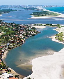
 Panoramic view of Pajucara beach and Ponta Verde (in the background)
Food
[
edit
]
Gastronomy include fishes, shrimps, crabs and lobsters are some of Maceio's specialties. Fresh seafood is prepared from local recipes, such as tapioca, acaraje, carne-de-sol, cuscuz de tapioca. A kind of mollusk, the sururu, is appreciated in the city and is incorporated in many typical dishes.
Transportation
[
edit
]
Public Transportation
[
edit
]
 Maceio Light Train
 Zumbi dos Palmares International Airport.
 Port of Maceio.
Maceio is served by
Maceio Urban Rail
, a light rail system.
International Airport
[
edit
]
Zumbi dos Palmares International Airport
located outside Maceio serves the area with international connections to
Lisbon
in Portugal and
Buenos Aires
in Argentina, as well as cities throughout
Brazil
.
In 2021 the airport handled 1,893,812 passengers.
Port
[
edit
]
The Port of Jaragua is a Brazilian port located in Maceio. The commercial and economic development of the Port of Jaragua, next to the margins of the Mundau lagoon, was responsible for the emergence of an important settlement that received the name of Maceio and later became the present capital of Alagoas. The Port of Jaragua is situated in a natural port area that facilitates the ships docking. During the
Brazilian colonial period
, the most important products exported from there port were sugar, tobacco, coconut and spices. The Biggest Cruise Ship to attract at port was
MSC Seashore
in 2022.
Highways
[
edit
]
Maceio is connected to the main cities of
Brazil
by the
BR-104
,
BR-101
,
BR-316
and AL-101 highways. The distances to other Brazilian cities are shown below:
Twin towns ? sister cities
[
edit
]
Neighbourhoods
[
edit
]
There are today about 50 districts in Maceio:
- Antares
- Barro Duro
- Bebedouro
- Benedito Bentes
- Bom Parto
- Canaa
- Centro de Maceio (Downtown)
- Cha de Bebedouro
- Cha da Jaqueira
- Cidade Universitaria
- Clima Bom
- Cruz das Almas
- Farol
- Feitosa
- Fernao Velho
- Garca Torta
- Gruta de Lourdes
- Guaxuma
- Ipioca
- Jacarecica
- Jacintinho
- Jaragua
- Jardim Petropolis
- Jatiuca
- Levada
- Mangabeiras
- Mutange
- Ouro Preto
- Pajucara
- Pescaria
- Pinheiro
- Pitanguinha
- Poco
- Ponta da Terra
- Ponta Grossa
- Ponta Verde
- Pontal da Barra
- Prado
- Petropolis
- Riacho Doce
- Rio Novo
- Santa Amelia
- Santo Amaro
- Santos Dumont
- Sao Jorge
- Serraria
- Tabuleiro do Martins
- Trapiche da Barra
- Vergel do Lago.
Surrounding highlights
[
edit
]
 Maceio State Museum.
Notable people
[
edit
]
 Zagallo football coach born in Maceio.
- Arthur Lira
, president of the Chamber of Deputies of Brazil.
- Bruna Tenorio
, fashion model.
- Bruno de Barros
, Brazilian sprinter, Olympic medallist.
- Mauricio Borges
, Brazilian volleyball player, Olympic champion.
- Djavan
, singer and musician.
- Fernando Collor de Mello
, Brazilian president from 1990 - 1992.
- Floriano Peixoto
, second president of the Brazilian republic.
- Graciliano Ramos
, Brazilian writer and journalist.
- Tiago Fernandes
, former Brazilian tennis player, champion of the 2010 Australian Open at Boys Singles
- Zagallo
(Mario Jorge Lobo Zagallo),
football
coach.
- Maria Eduarda Arakaki
, considered the best Brazilian rhythmic gymnast of all time.
- Yohansson Nascimento
, athlete, paralympic champion.
- Nise da Silveira
, psychiatrist.
- Kepler Laveran Lima Ferreira
aka 'Pepe', footballer.
- Adriano Gabiru
, football player, winner of the
2006 FIFA Club World Cup
playing for
Sport Club Internacional
.
- Roberto Firmino
, footballer.
- Roberval Davino
,
football
coach.
- Sandra Suruagy
, volleyball player, Olympic medallist
- Manuel Deodoro da Fonseca
[
citation needed
]
, First Brazilian President
See also
[
edit
]
References
[
edit
]
External links
[
edit
]
|
|---|
|
| Arapiraca
| | |
|---|
| Palmeira dos Indios
| |
|---|
| Traipu
| |
|---|
| Litoral Norte Alagoano
| |
|---|
| Maceio
| |
|---|
| Mata Alagoana
| |
|---|
| Penedo
| |
|---|
| Sao Miguel dos Campos
| |
|---|
| Serrana dos Quilombos
| |
|---|
| Alagoana do Sertao do Sao Francisco
| |
|---|
| Batalha
| |
|---|
| Santana do Ipanema
| |
|---|
| Serrana do Sertao Alagoano
| |
|---|
|
|---|
| International
| |
|---|
| National
| |
|---|
| Geographic
| |
|---|