54°0′N
2°30′W
/
54.000°N 2.500°W
/
54.000; -2.500
Geography of the United Kingdom
 |
| Continent
| Europe
|
|---|
| Region
| Northwestern Europe
|
|---|
| Coordinates
| 54°0′N
2°30′W
/
54.000°N 2.500°W
/
54.000; -2.500
|
|---|
| Area
| Ranked 78th
|
|---|
| ? Total
| 244,376 km
2
(94,354 sq mi)
|
|---|
| ? Land
| 99.3%
|
|---|
| ? Water
| 0.7%
|
|---|
| Coastline
| 12,429 km (7,723 mi)
|
|---|
| Borders
| 499 km (310 mi) land border with
Republic of Ireland
|
|---|
| Highest point
| Ben Nevis
1,345 m (4,413 ft)
|
|---|
| Lowest point
| The Fens
?4 m (?13 ft)
|
|---|
| Longest river
| River Severn
354 km (220 mi)
|
|---|
| Largest lake
| Lough Neagh
392 km
2
(151 sq mi)
|
|---|
| Climate
| Temperate
, with some areas of
Scotland
being
Tundra
, and
Subarctic
|
|---|
| Terrain
| Mountainous area to the north and west, lowland area to the south and east.
|
|---|
| Natural resources
| Coal, oil (continental shelf of the North Sea), natural gas, tin, limestone, iron, salt, clay, lead
|
|---|
| Natural hazards
| Storms, floods
|
|---|
| Environmental issues
| Biodiversity loss
, sulphur dioxide emissions from power plants, some rivers are contaminated by agricultural waste, wastewater into the sea
|
|---|
| Exclusive economic zone
| In Europe: 773,676 km
2
(298,718 sq mi)
All overseas territories: 6,805,586 km
2
(2,627,651 sq mi)
|
|---|
|
| [a]
[1]
[2]
|
The
United Kingdom
is a
sovereign state
located off the north-western coast of
continental Europe
. With a total area of approximately 244,376 square kilometres (94,354 sq mi),
[a]
[1]
the UK occupies the major part of the
British Isles
archipelago
and includes the island of
Great Britain
, the north-eastern one-sixth of the island of
Ireland
and many smaller surrounding islands.
[3]
It is the world's 7th largest
island country
.
[4]
The mainland areas lie between latitudes 49°N and 59°N (the
Shetland Islands
reach to nearly 61°N), and longitudes 8°W to 2°E. The
Royal Observatory, Greenwich
, in south-east London, is the defining point of the
Prime Meridian
.
The UK lies between the
North Atlantic
and the
North Sea
, and comes within 35 km (22 mi) of the north-west coast of
France
, from which it is separated by the
English Channel
. It shares a 499 km (310 mi) international land boundary with the
Republic of Ireland
.
[5]
[6]
The
Channel Tunnel
bored beneath the English Channel now links the UK with France.
The
British Overseas Territories
and
Crown Dependencies
are covered in their own respective articles,
see below
.
Area
[
edit
]
The total area of the United Kingdom according to the
Office for National Statistics
is 244,376 square kilometres (94,354 sq mi),
[a]
[1]
comprising the island of
Great Britain
, the northeastern one-sixth of the island of Ireland (Northern Ireland) and many smaller islands. This makes it the 7th largest
island country
in the world.
[4]
England
is the largest
country of the United Kingdom
, at 130,462 square kilometres (50,372 sq mi) accounting for just over half the total area of the UK.
[a]
[1]
Scotland
at 78,801 square kilometres (30,425 sq mi), is second largest, accounting for about a third of the area of the UK.
[a]
[1]
Wales
and
Northern Ireland
are much smaller, covering 20,783 and 14,330 square kilometres (8,024 and 5,533 sq mi) respectively.
[a]
[1]
The area of the countries of the United Kingdom is set out in the table below. Information about the area of
England
, the largest
country
, is also broken down by
region
.
| Rank
|
Name
|
Area
|
| 1
|
England
?
South West
[7]
?
East of England
?
South East
[8]
?
East Midlands
?
Yorkshire and the Humber
?
North West
[9]
?
West Midlands
[10]
?
North East
[11]
?
London
[12]
|
132,938 km
2
23,837 km
2
19,120 km
2
19,096 km
2
15,627 km
2
15,420 km
2
14,165 km
2
12,998 km
2
8,592 km
2
1,572 km
2
|
| 2
|
Scotland
|
80,239 km
2
|
| 3
|
Wales
|
21,225 km
2
|
| 4
|
Northern Ireland
|
14,130 km
2
|
|
|
United Kingdom
|
248,532 km
2
|
|
|
Overseas territories
|
1,727,570 km
2
|
The
British Antarctic Territory
, which covers an area of 1,709,400 km
2
(660,000 sq mi) is geographically the largest of the British Overseas Territories followed by the
Falkland Islands
which covers an area of 12,173 km
2
(4,700 sq mi). The remaining twelve overseas territories cover an area 5,997 km
2
(2,315 sq mi).
Other countries with very similar land areas to the United Kingdom include
Guinea
(slightly larger),
Uganda
,
Ghana
and
Romania
(all slightly smaller). The UK is the world's 80th largest country by land area and the 10th largest in Europe (if European Russia is included).
Physical geography
[
edit
]
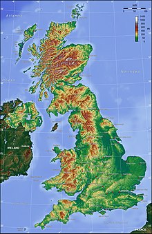 UK's topography
 As this
geological
map of
Great Britain
demonstrates, the
geology
of the
UK
is varied and complex.
As this
geological
map of
Great Britain
demonstrates, the
geology
of the
UK
is varied and complex.
The
physical geography
of the UK varies greatly.
England
consists of mostly lowland terrain, with upland or mountainous terrain only found north-west of the
Tees?Exe line
. The upland areas include the
Lake District
, the
Pennines
,
North York Moors
,
Exmoor
and
Dartmoor
. The lowland areas are typically traversed by ranges of low hills, frequently composed of
chalk
, and flat plains.
Scotland
is the most mountainous country in the UK and its physical geography is distinguished by the
Highland Boundary Fault
which traverses the Scottish mainland from
Helensburgh
to
Stonehaven
. The faultline separates the two distinctively different regions of the
Highlands
to the north and west, and the
Lowlands
to the south and east. The Highlands are predominantly mountainous, containing the majority of Scotland's mountainous landscape, while the Lowlands contain flatter land, especially across the
Central Lowlands
, with upland and mountainous terrain located at the
Southern Uplands
.
Wales
is mostly mountainous, though
south Wales
is less mountainous than
north
and
mid Wales
.
Northern Ireland
consists of mostly hilly landscape and its geography includes the
Mourne Mountains
as well as
Lough Neagh
, at 388 square kilometres (150 sq mi), the largest body of water in the UK.
[13]
The overall
geomorphology
of the UK was shaped by a combination of forces including
tectonics
and
climate change
, in particular
glaciation
in northern and western areas.
The tallest mountain in the UK (and British Isles) is
Ben Nevis
, in the
Grampian Mountains
, Scotland. The longest river is the
River Severn
which flows from
Wales
into England. The largest lake by surface area is
Lough Neagh
in Northern Ireland, though Scotland's
Loch Ness
has the largest volume.
Geology
[
edit
]
The geology of the UK is complex and diverse, a result of it being subject to a variety of
plate tectonic
processes over a very extended period of time. Changing latitude and sea levels have been important factors in the nature of sedimentary sequences, whilst successive continental collisions have affected its
geological structure
with major faulting and folding being a legacy of each
orogeny
(mountain-building period), often associated with
volcanic
activity and the metamorphism of existing rock sequences. As a result of this eventful geological history, the UK shows a rich variety of
landscapes
.
[14]
Precambrian
[
edit
]
The oldest rocks in the British Isles are the
Lewisian gneisses
, metamorphic rocks found in the far north-west of Scotland and in the
Hebrides
(with a few small outcrops elsewhere), which date from at least 2,700 Ma (Ma = million years ago). South and east of the gneisses are a complex mixture of rocks forming the North West
Highlands
and
Grampian
Highlands in Scotland. These are essentially the remains of folded
sedimentary rocks
that were deposited between 1,000 Ma and 670 Ma over the gneiss on what was then the floor of the
Iapetus Ocean
.
Palaeozoic
[
edit
]
At 520 Ma, what is now Great Britain was split between two
continents
; the north of Scotland was located on the continent of
Laurentia
at about 20° south of the
equator
, while the rest of the country was on the continent of
Gondwana
near the
Antarctic Circle
. In Gondwana, England and
Wales
were largely submerged under a shallow sea studded with
volcanic
islands. The remains of these islands underlie much of central England with small outcrops visible in many places.
About 500 Ma southern Britain, the east coast of
North America
and south-east
Newfoundland
broke away from Gondwana to form the continent of
Avalonia
, which by 440 Ma had drifted to about 30° south. During this period north Wales was subject to
volcanic
activity. The remains of these volcanoes are still visible, one example of which is
Rhobell Fawr
dating from 510 Ma. Large quantities of volcanic
lava
and ash known as the
Borrowdale Volcanics
covered the
Lake District
and this can still be seen in the form of mountains such as
Helvellyn
and
Scafell Pike
.
Between 425 and 400 Ma
Avalonia
had joined with the continent of
Baltica
, and the combined landmass collided with
Laurentia
at about 20° south, joining the southern and northern halves of
Great Britain
together. The resulting
Caledonian Orogeny
produced an
Alpine
-style mountain range in much of north and west Britain.
The collision between continents continued during the
Devonian period
, producing uplift and subsequent erosion, resulting in the deposition of numerous sedimentary rock layers in lowlands and seas. The
Old Red Sandstone
and the contemporary volcanics and marine sediments found in
Devon
originated from these processes.
Around 360 Ma Great Britain was lying at the equator, covered by the warm shallow waters of the
Rheic Ocean
, during which time the Carboniferous Limestone was deposited, as found in the
Mendip Hills
and the
Peak District
of
Derbyshire
. Later,
river deltas
formed and the sediments deposited were colonised by
swamps
and
rain forest
. It was in this environment that the
Coal Measures
were formed, the source of the majority of Britain's extensive
coal
reserves.
Around 280 Ma the
Variscan orogeny
mountain-building period occurred, again due to collision of continental plates, causing major deformation in south-west England. The general region of Variscan folding was south of an east?west line roughly from south
Pembrokeshire
to
Kent
. Towards the end of this period
granite
was formed beneath the overlying rocks of
Devon
and
Cornwall
, now exposed at
Dartmoor
and
Bodmin Moor
.
By the end of the Carboniferous period the various continents of the Earth had fused to form the super-continent of
Pangaea
.
Britain
was located in the interior of Pangea where it was subject to a hot arid desert climate with frequent flash floods leaving deposits that formed beds of red
sedimentary
rock.
Mesozoic
[
edit
]
As Pangaea drifted during the
Triassic
, Great Britain moved away from the equator until it was between 20° and 30° north. The remnants of the Variscan uplands in
France
to the south were eroded down, resulting in layers of the New Red Sandstone being deposited across central England.
Pangaea
began to break up at the start of the
Jurassic
period. Sea levels rose and Britain drifted on the
Eurasian Plate
to between 31° and 40° north. Much of Britain was under water again, and
sedimentary rocks
were deposited and can now be found underlying much of England from the
Cleveland Hills
of
Yorkshire
to the
Jurassic Coast
in
Dorset
. These include
sandstones
,
greensands
,
oolitic
limestone
of the
Cotswold Hills
,
corallian limestone
of the
Vale of White Horse
and the
Isle of Portland
. The burial of
algae
and
bacteria
below the mud of the seafloor during this time resulted in the formation of
North Sea oil
and
natural gas
.
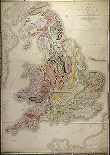 1815 geological by
William Smith
1815 geological by
William Smith
The modern continents having formed, the
Cretaceous
saw the formation of the
Atlantic Ocean
, gradually separating northern Scotland from
North America
. The land underwent a series of uplifts to form a fertile plain. After 20 million years or so, the seas started to flood the land again until much of Britain was again below the sea, though sea levels frequently changed.
Chalk
and
flints
were deposited over much of Great Britain, now notably exposed at the
White Cliffs of Dover
and the
Seven Sisters
, and also forming
Salisbury Plain
.
Cenozoic
[
edit
]
Between 63 and 52 Ma, the last volcanic rocks in Great Britain were formed. The major eruptions at this time produced the
Antrim Plateau
, the
basaltic
columns of the
Giant's Causeway
and
Lundy Island
in the
Bristol Channel
.
The
Alpine Orogeny
that took place in Europe about 50 Ma, was responsible for the folding of strata in southern England, producing the
London Basin
syncline
, the
Weald-Artois Anticline
to the south, the
North Downs
,
South Downs
and
Chiltern Hills
.
During the period the
North Sea
formed, Britain was
uplifted
. Some of this uplift was along old lines of weakness left from the Caledonian and Variscan Orogenies long before. The uplifted areas were then eroded, and further sediments, such as the
London Clay
, were deposited over southern England.
The major changes during the last 2 million years were brought about by
several recent ice ages
. The most severe was the
Anglian Glaciation
, with ice up to 1,000 m (3,300 ft) thick that reached as far south as
London
and
Bristol
. This took place between about 478,000 to 424,000 years ago, and was responsible for the diversion of the
River Thames
onto its present course. During the most recent
Devensian glaciation
, which ended a mere 10,000 years ago, the icesheet reached south to
Wolverhampton
and
Cardiff
. Among the features left behind by the ice are the
fjords
of the west coast of Scotland, the
U-shaped valleys
of the
Lake District
and
erratics
(blocks of rock) that have been transported from the
Oslo
region of
Norway
and deposited on the coast of
Yorkshire
.
Amongst the most significant geological features created during the last twelve thousand years are the
peat
deposits of Scotland, and of coastal and upland areas of England and Wales.
At the present time Scotland is continuing to rise as a result of the weight of Devensian ice being lifted. Southern and eastern England is sinking, generally estimated at 1 mm (
1
⁄
25
in) per year, with the London area sinking at double the speed partly due to the continuing
compaction
of the recent clay deposits.
Mountains and hills
[
edit
]
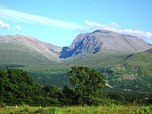 At 1,345 metres (4,413 ft),
Ben Nevis
is the highest peak in the
UK
.
At 1,345 metres (4,413 ft),
Ben Nevis
is the highest peak in the
UK
.
The ten tallest
mountains
in the UK are all found in Scotland. The highest peaks in each part of the UK are:
- Scotland:
Ben Nevis
, 1,345 metres (4,413 ft)
- Wales:
Snowdon
(Yr Wyddfa), (
Snowdonia
), 1,085 metres (3,560 ft)
- England:
Scafell Pike
(
Cumbrian Mountains
), 978 metres (3,209 ft)
- Northern Ireland:
Slieve Donard
(
Mourne Mountains
), 852 metres (2,795 ft)
The ranges of mountains and
hills
in the UK include:
- Scotland:
Cairngorms
,
Scottish Highlands
,
Southern Uplands
,
Grampian Mountains
,
Monadhliath Mountains
,
Ochil Hills
,
Campsie Fells
,
Cuillin
- Wales:
Brecon Beacons
(Bannau Brycheiniog),
Cambrian Mountains
(Mynyddoedd Cambria),
Clwydian Hills
(Bryniau Clwyd),
Snowdonia
(Eryri),
Black Mountains
(Y Mynyddoedd Duon),
Preseli Hills
(Y Preseli)
- England:
Cheviot Hills
,
Chilterns
,
Cotswolds
,
Dartmoor
,
Lincolnshire Wolds
,
Exmoor
,
Lake District
,
Malvern Hills
,
Mendip Hills
,
North Downs
,
Peak District
,
Pennines
,
South Downs
,
Shropshire Hills
,
Yorkshire Wolds
- Northern Ireland:
Mourne Mountains
,
Antrim Plateau
,
Sperrin Mountains
The lowest point of the UK is in
the Fens
of
East Anglia
, in England, parts of which lie up to 4 metres (13 ft) below
sea level
.
Rivers and lakes
[
edit
]
- Main articles
The longest river in the UK is the
River Severn
(220 mi; 350 km) which flows through both Wales and England.
The longest rivers in the UK contained fully within each of its constituent nations are:
The largest lakes (by surface area) in the UK by country are:
The deepest lake in the UK is
Loch Morar
with a maximum depth of 309 metres (1,014 ft);
Loch Ness
is second at 228 metres (748 ft) deep. The deepest lake in England is
Wastwater
which achieves a depth of 79 metres (259 ft).
Loch Ness
is the UK's largest lake in terms of volume.
Artificial waterways
[
edit
]
Main articles:
Waterways in the United Kingdom
,
Canals of Great Britain
,
Dams and reservoirs in United Kingdom
As a result of its industrial history, the United Kingdom has an extensive system of
canals
, mostly built in the early years of the
Industrial Revolution
, before the rise of competition from the
railways
. The United Kingdom also has numerous
dams
and
reservoirs
to store water for drinking and industry. The generation of
hydroelectric power
is rather limited, supplying less than 2% of British electricity, mainly from the Scottish Highlands.
Coastline
[
edit
]
 United Kingdom maritime claims
The UK has a
coastline
which measures about 12,429 km (7,723 mi).
[15]
The heavy indentation of the coastline helps to ensure that no location is more than 125 km (78 mi) from tidal waters.
The UK claims jurisdiction over the
continental shelf
, as defined in continental shelf orders or in accordance with agreed upon boundaries, an exclusive fishing zone of 200
nmi
(370.4 km; 230.2 mi), and territorial sea of 12 nmi (22.2 km; 13.8 mi).
The UK has an
Exclusive Economic Zone
of 773,676 km
2
(298,718 sq mi) in
Europe
. However, if all crown dependencies and overseas territories are included then the total EEZ is 6,805,586 km
2
(2,627,651 sq mi) which is the 5th largest in the world.
Inlets
[
edit
]
Headlands
[
edit
]
The geology of the United Kingdom is such that there are many headlands along its coast. A
list of headlands of the United Kingdom
details many of them.
Tidal flats
[
edit
]
A recent global remote sensing analysis suggested that there were 2,697 km
2
(1,041 sq mi) of tidal flats in the United Kingdom, making it the 12th ranking country in terms of how much tidal flat occurs there.
[16]
Islands
[
edit
]
In total, it is estimated that the UK is made up of over one thousand small islands, the majority located off the north and west coasts of Scotland. About 130 of these are inhabited according to the 2001 census.
The largest island in the UK is
Great Britain
. The largest islands by constituent country are
Lewis and Harris
in Scotland at 841 sq mi (2,180 km
2
), Wales'
Anglesey
at 276 sq mi (710 km
2
), the
Isle of Wight
in England at 147 sq mi (380 km
2
), and
Rathlin Island
in Northern Ireland at roughly 6 sq mi (16 km
2
);
Climate
[
edit
]
The climate of the UK is generally
temperate
, although significant local variation occurs, particularly as a result of altitude and distance from the coast. In general the south of the country is warmer than the north, and the west wetter than the east. Due to the warming influence of the
Gulf Stream
, the UK is significantly warmer than some other locations at a similar latitude, such as
Newfoundland
.
The prevailing winds are southwesterly, from the
North Atlantic Current
. More than 50% of the days are overcast.
[17]
There are few natural hazards, although there can be strong winds and floods, especially in winter.
Average annual rainfall varies from over 3,000 mm (118.1 in) in the
Scottish Highlands
down to 553 mm (21.8 in) in
Cambridge
. The county of
Essex
is one of the driest in the UK, with an average annual rainfall of around 600 mm (23.6 in), although it typically rains on over 100 days per year. In some years rainfall in Essex can be below 450 mm (17.7 in), less than the average annual rainfall in
Jerusalem
and
Beirut
.
The highest temperature recorded in the UK was 40.3 °C (104.5 °F) at
Coningsby
in
Lincolnshire
, on 20 July 2022.
[18]
The lowest was ?27.2 °C (?17.0 °F) recorded at
Braemar
in the
Grampian Mountains
, Scotland, on 11 February 1895 and 10 January 1982 and
Altnaharra
, also in Scotland, on 30 December 1995.
Human geography
[
edit
]
Largest urban areas of the United Kingdom
(England and Wales: 2011 census built-up area;
[19]
Scotland: 2016 estimates settlement;
[20]
Northern Ireland: 2001 census urban area)
[21]
|
| Rank
|
Urban area
|
Pop.
|
Principal settlement
|
Rank
|
Urban area
|
Pop.
|
Principal settlement
|
| 1
|
Greater London
|
9,787,426
|
London
|
11
|
Bristol
|
617,280
|
Bristol
|
| 2
|
Greater Manchester
|
2,553,379
|
Manchester
|
12
|
Edinburgh
|
512,150
|
Edinburgh
|
| 3
|
West Midlands
|
2,440,986
|
Birmingham
|
13
|
Leicester
|
508,916
|
Leicester
|
| 4
|
West Yorkshire
|
1,777,934
|
Leeds
|
14
|
Belfast
|
483,418
|
Belfast
|
| 5
|
Greater Glasgow
|
985,290
|
Glasgow
|
15
|
Brighton & Hove
|
474,485
|
Brighton
|
| 6
|
Liverpool
|
864,122
|
Liverpool
|
16
|
South East Dorset
|
466,266
|
Bournemouth
|
| 7
|
South Hampshire
|
855,569
|
Southampton
|
17
|
Cardiff
|
390,214
|
Cardiff
|
| 8
|
Tyneside
|
774,891
|
Newcastle upon Tyne
|
18
|
Teesside
|
376,633
|
Middlesbrough
|
| 9
|
Nottingham
|
729,977
|
Nottingham
|
19
|
Stoke-on-Trent
|
372,775
|
Stoke-on-Trent
|
| 10
|
Sheffield
|
685,368
|
Sheffield
|
20
|
Coventry
|
359,262
|
Coventry
|
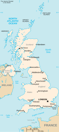 The
United Kingdom
is composed of four parts:
England
,
Northern Ireland
,
Scotland
and
Wales
.
The
United Kingdom
is composed of four parts:
England
,
Northern Ireland
,
Scotland
and
Wales
.
 The United Kingdom's
cities
, other large centres, and selected smaller places
The United Kingdom's
cities
, other large centres, and selected smaller places
Demographics
[
edit
]
Political geography
[
edit
]
National government
[
edit
]
The UK is governed as a whole by the
Parliament of the United Kingdom
. Of the four countries that make the UK,
Scotland
,
Wales
and
Northern Ireland
have devolved administrations and legislatures:
The
devolved administrations and legislatures
can make laws in a number of areas, such as culture, education, local government, and environment.
By contrast, England has no devolved system of government, that is, the Parliament of the United Kingdom makes laws for England, as well as for
reserved
matters in Northern Ireland, Scotland and Wales. England is governed by UK government ministers and legislated for by the UK parliament. The
London region
has a devolved assembly but proposals for elected
Regional Assemblies in England
were rejected in the first referendum covering
North East England
. (
See
Government of England
.
)
The UK (specifically, Northern Ireland) has an international land boundary with the
Republic of Ireland
of 499 km.
[5]
[6]
There is also a boundary between the jurisdiction of France and the UK on the Channel Tunnel.
Local government
[
edit
]
Each part of the UK is subdivided into further local governmental regions:
Historically the UK was divided into counties or
shires
: administrative areas through which all civil responsibilities of the
government
were passed. Each county or shire had a
county town
as its administrative centre and was divided into individual
parishes
that were defined along
ecclesiastic
boundaries.
Between 1889 (1890 in Scotland) and 1974, the political boundaries were based on the traditional counties, but due to changes in population centres, the traditional counties became impractical as local government areas in certain highly urbanised areas. The
Local Government Act 1972
created a new system of administrative counties, designed to take account of the widely differing populations across different parts of the country.
In the 1990s further population growth led to more political changes on a local level.
Unitary authorities
were formed across the entirety of Scotland and Wales, and in larger
cities
in England. Many unpopular administrative counties were also abolished at this time, leading to a mixture of two-tier and single-purpose authorities. Further reorganisations are planned if and when regional assemblies in England are revisited in the future.
Economic geography
[
edit
]
The economic geography of the UK reflects not only its current position in the global economy, but its long history both as a trading nation and an
imperial power
.
The UK led the
industrial revolution
and its highly urban character is a legacy of this, with all its major cities being current or former centres of various forms of manufacturing. However, this in turn was built on its
exploitation of natural resources
, especially
coal
and
iron ore
.
Primary industry
[
edit
]
The UK's primary industry was once dominated by the
coal
industry, heavily concentrated in the north, the
Midlands
and
south Wales
. This is all but gone and the major primary industry is
North Sea oil
. Its activity is concentrated on the
UK Continental Shelf
to the north-east of
Scotland
.
Manufacturing
[
edit
]
The UK's heavy manufacturing drove the industrial revolution. A map of the major UK cities gives a good picture of where this activity occurred, in particular
Belfast
,
Birmingham
,
Glasgow
,
Liverpool
,
London
,
Manchester
,
Newcastle
and
Sheffield
. Today there is no heavy manufacturing industry in which UK-based firms can be considered world leaders. However, areas of the UK still have a notable manufacturing base, including the
Midlands
which remains a strong manufacturing centre, and the
North West
which accounts for 60% of the United Kingdom's manufacturing output.
[22]
More recently, high technology firms have concentrated largely along the
M4 motorway
, partly because of access to
Heathrow Airport
, but also because of agglomeration economies.
Finance and services
[
edit
]
Once, every large city had a
stock exchange
. Now, the UK financial industry is concentrated overwhelmingly in the
City of London
and
Canary Wharf
, with back office and administrative operations often dispersed around the south of England. London is one of the world's great financial centres and is usually referred to as a
world city
. There is also a significant legal and
ebusiness
industry in
Leeds
.
Regional disparity
[
edit
]
The effect of changing economic fortune has contributed to the creation of the so-called
North-South divide
, in which decaying industrial and ex-industrial areas of Northern England, Scotland and Wales contrast with the wealthy, finance and technology-led southern economy. This has led successive governments to develop
regional policy
to try to rectify the imbalance. However, this is not to say that the north?south divide is uniform; some of the worst pockets of deprivation can be found in
London
, whilst parts of
Cheshire
and
North Yorkshire
are very wealthy. Nor is the
North-South divide
limited to the economic sphere; cultural and political divisions weigh heavily too.
Natural resources
[
edit
]
Historically, much of the United Kingdom was
forested
. Since
prehistoric
times, man has
deforested
much of the United Kingdom.
Agriculture
is
intensive
, highly
mechanised
, and efficient by
European
standards, producing about 60% of food needs with only 1% of the labour force. It contributes around 2% of
GDP
. Around two thirds of production is devoted to
livestock
, one third to
arable
crops.
In 1993, it was estimated that
land use
was:
The UK has a variety of natural resources including:
- Geological:
coal
,
petroleum
,
natural gas
,
limestone
,
chalk
,
gypsum
,
silica
,
rock salt
,
china clay
,
iron ore
,
tin
,
silver
,
gold
,
lead
.
- Agricultural:
arable land
,
wheat
,
barley
,
sheep
The UK has large
coal
,
natural gas
, and
oil
reserves; primary energy production accounts for 10% of
GDP
, one of the highest shares of any
industrial nation
. Due to the island location of the UK, the country has great potential for generating electricity from
wave power
and
tidal power
, although these have not yet been exploited on a commercial basis.
Environment
[
edit
]
Current issues
[
edit
]
| This section needs to be
updated
.
Please help update this article to reflect recent events or newly available information.
(
October 2022
)
|
England is one of the most densely populated countries/regions in the world, and the most densely populated major nation in Europe.
[23]
The high population density (especially in the southeast of England) coupled with a changing climate, is likely to put extreme pressure on the United Kingdom's water resources in the future.
[24]
The United Kingdom is reducing
greenhouse
gas emissions. It has met
Kyoto Protocol
target of a 12.5% reduction from 1990 levels and intends to meet the legally binding target of a 20% cut in emissions by 2010. By 2015, to recycle or compost at least 33% of household waste. Between 1998-99 and 1999?2000, household
recycling
increased from 8.8% to 10.3% respectively.
According to a 2018 survey for the
World Wide Fund for Nature
, the United Kingdom is one of the most nature-depleted countries in the world, coming in 189th place out of 218 countries.
[25]
[26]
International agreements
[
edit
]
The United Kingdom is a party to many international agreements, including:
Air Pollution, Air Pollution-
Nitrogen Oxides
, Air Pollution-
Sulphur
94, Air Pollution-Volatile Organic Compounds,
Antarctic-Environmental Protocol
,
Antarctic-Marine Living Resources
,
Antarctic Seals
,
Antarctic Treaty
,
Biodiversity
,
Climate Change
, Climate Change-Kyoto Protocol,
Desertification
, Endangered Species, Environmental Modification, Hazardous Wastes, Law of the Sea, Marine Dumping, Marine Life Conservation, Nuclear Test Ban, Ozone Layer Protection, Ship Pollution, Tropical Timber 83, Tropical Timber 94,
Wetlands
and
Whaling
.
The UK has signed, but not ratified, the international agreement on Air Pollution-Persistent Organic Pollutants.
Geography of dependent territories
[
edit
]
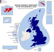 Map of the UK, overseas territories and crown dependencies at the same geographic scale
Crown dependencies
[
edit
]
Overseas territories
[
edit
]
See also
[
edit
]
Notes
[
edit
]
References
[
edit
]
- ^
a
b
c
d
e
f
"Standard Area Measurements (Latest) for Administrative Areas in the United Kingdom"
.
Open Geography Portal
. Office for National Statistics. 24 April 2024
. Retrieved
6 May
2024
.
- ^
"A Beginners Guide to UK Geography (2023)"
.
Open Geography Portal
. Office for National Statistics. 24 August 2023
. Retrieved
9 December
2023
.
- ^
Oxford English Dictionary: "British Isles: a geographical term for the islands comprising Great Britain and Ireland with all their offshore islands including the Isle of Man and the Channel Islands."
- ^
a
b
"Island Countries of the World"
. WorldAtlas.com. Archived from
the original
on 7 December 2017
. Retrieved
10 August
2019
.
- ^
a
b
Ordnance Survey of Northern Ireland, 1999
- ^
a
b
MFPP Working Paper No. 2, "The Creation and Consolidation of the Irish Border" by KJ Rankin and published in association with Institute for British-Irish Studies, University College Dublin and Institute for Governance, Queen's University, Belfast (also printed as
IBIS working paper no. 48)
- ^
"The South West ? Key Facts"
.
gosw.gov.uk
. Government Office for the South West. Archived from
the original
on 22 March 2007
. Retrieved
18 April
2007
.
- ^
"Facts and Figures about the South East"
.
gose.gov.uk
. Government Office for the South East. Archived from
the original
on 28 September 2007
. Retrieved
18 April
2007
.
- ^
"Regional Profile"
.
gonw.gov.uk
. Government Office for the North West. Archived from
the original
on 3 May 2007
. Retrieved
18 April
2007
.
- ^
"Regional Profile"
.
gowm.gov.uk
. Government Office for the West Midlands. Archived from
the original
on 21 September 2007
. Retrieved
18 April
2007
.
- ^
"Regional Profile"
.
gos.gov.uk
. Government Office for the North East. Archived from
the original
on 28 September 2007
. Retrieved
18 April
2007
.
- ^
"Our Region"
.
gol.gov.uk
. Government Office for London. Archived from
the original
on 20 September 2007
. Retrieved
18 April
2007
.
- ^
"Geography of Northern Ireland"
. University of Ulster
. Retrieved
25 September
2017
.
- ^
Toghill, Peter (2000).
The Geology of Britain: An Introduction
. Shrewsbury: Swan Hill Press.
ISBN
1-85310-890-1
.
- ^
The Department for Environment, Food & Rural Affairs (2009).
"Factsheet Marine Conservation Zones"
(PDF)
.
defra.gov.uk
. DEFRA. Archived from
the original
(PDF)
on 23 April 2014
. Retrieved
21 April
2014
.
- ^
Murray, N.J.; Phinn, S.R.; DeWitt, M.; Ferrari, R.; Johnston, R.; Lyons, M.B.; Clinton, N.; Thau, D.; Fuller, R.A. (2019).
"The global distribution and trajectory of tidal flats"
.
Nature
.
565
(7738): 222?225.
doi
:
10.1038/s41586-018-0805-8
.
PMID
30568300
.
S2CID
56481043
.
- ^
"25 September 2017"
.
- ^
"Record breaking temperatures for the UK"
.
- ^
"2011 Census - Built-up areas"
.
ONS
. Retrieved
1 July
2013
.
- ^
"NRS ? Background Information Settlements and Localities"
(PDF)
.
National Records of Scotland
. Retrieved
29 September
2020
.
- ^
The UK's major urban areas
Office for National Statistics (Urban area of Belfast and connected settlements, Table 3.1, page 47)
- ^
"1,800 new jobs to be created at Manchester Airport"
.
ITV News
. 22 August 2012
. Retrieved
25 September
2017
.
- ^
Khan, Urmee (16 September 2008).
"England is most crowded country in Europe"
.
The Daily Telegraph
. London
. Retrieved
25 September
2017
.
- ^
McKie, Robin (22 January 2012).
"Urgent action needed to prevent England's rivers drying up"
. The Observer.
The Guardian
. London
. Retrieved
25 September
2017
.
- ^
Hobson, Sam.
"Is this the Future of UK nature?"
. World Wide Fund for Nature
. Retrieved
22 May
2020
.
- ^
"The UK's nature in crisis ? in pictures"
.
The Guardian
. London. 31 January 2019
. Retrieved
22 May
2020
.
External links
[
edit
]
|
|---|
| Sovereign states
| |
|---|
States with limited
recognition
| |
|---|
Dependencies and
other entities
| |
|---|
| Other entities
| |
|---|
|
|---|
| Sovereign states
| |
|---|
States with limited
recognition
| |
|---|
Dependencies and
other entities
| |
|---|
| Other entities
| |
|---|