Geographical features of Scotland
Geography of Scotland
 |
 |
| Continent
| Europe
|
|---|
| Region
| British Isles
|
|---|
| Area
| |
|---|
| ? Total
| 80,231 km
2
(30,977 sq mi)
|
|---|
| ? Land
| 97%
|
|---|
| ? Water
| 3%
|
|---|
| Coastline
| 11,796 km (7,330 mi)
|
|---|
| Borders
| England
154 km (96 mi)
|
|---|
| Highest point
| Ben Nevis
1,346 m (4,416 ft)
|
|---|
| Lowest point
| Atlantic Ocean
, 0 m
|
|---|
| Longest river
| River Tay
188 km (117 mi)
|
|---|
| Largest lake
| Loch Lomond
71.3 km
2
(27.5 sq mi)
|
|---|
| Climate
| Temperate
,
Subarctic
,
Tundra
|
|---|
| Terrain
| mountains
,
hills
,
forest
,
bog
,
urban
|
|---|
| Natural resources
| iron
,
zinc
,
potash
,
silica sand
,
coal
,
fish
,
timber
,
wildlife
,
petroleum
,
natural gas
,
hydropower
|
|---|
| Natural hazards
| windstorms
,
floods
|
|---|
| Environmental issues
| climate change
,
renewable energy
,
waste disposal
and
water pollution
|
|---|
|
| [1]
[2]
|
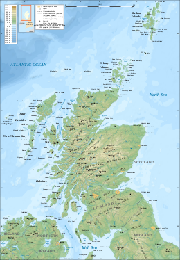
The
geography of Scotland
is varied, from rural lowlands to unspoilt uplands, and from large cities to sparsely inhabited islands. Located in
Northern Europe
,
Scotland
comprises the northern part of the island of
Great Britain
as well as 790 surrounding islands encompassing the major archipelagos of the
Shetland Islands
,
Orkney Islands
and the Inner and Outer
Hebrides
.
[3]
The
only land border
is with
England
, which runs for 96 miles (154 kilometres) in a northeasterly direction from the
Solway Firth
in the west to the
North Sea
on the east coast.
[4]
Separated by the
North Channel
, the island of Ireland lies 13 nautical miles (24 kilometres) from Mull of
Kintyre
on the Scottish mainland.
[5]
Norway is located 190 nmi (350 km) northeast of Scotland across the North Sea. The
Atlantic Ocean
, which fringes the coastline of western and northern Scotland and its islands, influences the
temperate
, maritime climate of the country.
[6]
Scotland contains the majority of mountainous terrain in the
UK
. The topography of Scotland is distinguished by the
Highland Boundary Fault
which traverses the Scottish mainland from
Helensburgh
to
Stonehaven
.
[7]
The faultline separates two distinctively different physiographic regions; namely the
Highlands
to the north and west and the
Lowlands
to the south and east.
[8]
The more rugged Highland region contains the majority of Scotland's mountainous terrain, including the highest peak,
Ben Nevis
.
Lowland areas, in the southern part of Scotland, are flatter and home to most of the population, especially the narrow waist of land between the
Firth of Clyde
and the
Firth of Forth
known as the
Central Belt
.
[8]
Glasgow
is the largest city in Scotland, although
Edinburgh
is the
capital
and political centre of the country.
[9]
While the Lowlands are less elevated, upland and mountainous terrain is located across the
Southern Uplands
.
An abundance of natural resources such as
coal
,
iron
and
zinc
contributed significantly to the industrial growth of Scotland during the 19th and early 20th centuries.
[10]
Today,
energy
is a major component of Scotland's economy.
[11]
Whilst Scotland is a large producer of
petroleum
, the production potential of
renewable energy
has emerged as an important economic and environmental issue in recent years.
[12]
Geology and morphology
[
edit
]
The land area of Scotland is 30,090 square miles (77,900 km
2
), 32% of the area of the United Kingdom (UK). The mainland of Scotland has 6,160 miles (9,910 km) of coastline.
The
morphology
of Scotland was formed by the action of
tectonic plates
, and subsequent erosion arising from
glaciation
. The major division of Scotland is the
Highland Boundary Fault
, which separates the land into 'highland' to the north and west, and 'lowland' to the south and east. The
Highlands of Scotland
are largely mountainous, and form the highest ground in the UK: they are bisected by the
Great Glen
into the
Grampian Mountains
to the southeast and the
Northwest Highlands
. The
Scottish Lowlands
can be further subdivided into the
Southern Uplands
, an area of rolling farmland and high
moorland
, and the lowland farmland of the
Central Belt
and eastern Scotland.
Scotland has an incomparable variety of
geology
for an area of its size.
The oldest rocks of Scotland are the
Lewisian gneisses
, which were formed in the
Precambrian
period, up to 3 billion years ago. They are among the oldest rocks in the world. During the Precambrian, the
Torridonian sandstones
and the
Moine
were also laid down. Further
sedimentary
deposits were formed through the
Cambrian
period, some of which
metamorphosed
into the
Dalradian
series. The area which would become Scotland was at this time close to the south pole.
During the
Silurian
period (439?409 Ma), the area which became Scotland was part of the continent of
Laurentia
. Across the
Iapetus Ocean
to the south, was the continent of
Baltica
. The two continents gradually collided, joining Scotland to the area which would become England and Europe. This event is known as the
Caledonian Orogeny
, and the
Highland Boundary Fault
marks this stitching together of continents. Silurian rocks form the
Southern Uplands
of Scotland, which was pushed up from the seabed during the collision. The highlands were also pushed up as a result of this collision, and may have been as high as the modern-day
Alps
at this time. The
Old Red Sandstones
were laid down in low-lying areas during this period.
Volcanic activity
occurred across Scotland as a result of the collision of the
tectonic plates
, with volcanoes in southern Scotland, and
magma chambers
in the north, which today form the
granite
mountains such as the
Cairngorms
.
During the
Carboniferous
period (363?290 Ma), Scotland lay close to the equator. Several changes in sea level occurred during this time. The
coal
deposits of
Lanarkshire
, and further sedimentary deposits, date from this time. More volcanic activity formed
Arthur's Seat
in
Edinburgh
, among other hills. By the
Triassic
, Scotland was a desert, the origin of large
sandstone
outcrops of the southwest. Although large deposits of
Cretaceous
rocks would have been laid down over Scotland, these have not survived erosion, as have the
chalks
of England.
By the
Tertiary
period, the tectonic plates were again moving, separating into modern-day
North America
and Europe with the creation of the
Atlantic Ocean
. The split occurred to the west of Scotland, leaving a chain of former volcanic sites through the
Hebrides
, including
Skye
and
St. Kilda
. This was the last period of rock formation in Scotland.
Physical geography
[
edit
]
Main points
[
edit
]
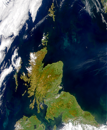 Scotland viewed from space
The main points of the Scottish mainland are:
It is often yet incorrectly stated that
John o' Groats
is the most northerly point of mainland Scotland. The pre-Union phrase "John o' Groats to
Maidenkirk
" was the Scottish equivalent of the British
Land's End to John o' Groats
.
The extreme points of Scotland, including outlying islands, are:
The geographical
centre of Scotland
lies a few miles from the village of
Newtonmore
in
Badenoch
, far to the north of the modern population heartlands.
[13]
The geographical centre of the mainland alone lies near the peak of
Schiehallion
.
Land use
[
edit
]
The total land area of Scotland is 8,023,947 hectares. Grasses and rough grazing account for 67% of the land area, forest and woodland 17%, urban development 8%, crops and fallow 7%, and other agricultural land accounts for 2%.
[14]
Topography, mountains and hills
[
edit
]
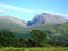 Ben Nevis
is the highest peak in Great Britain.
Ben Nevis
is the highest peak in Great Britain.
Scotland contains the most mountainous terrain in Great Britain. Much of the highest uplands lie to the north and west of the Highland Boundary Fault in the
Northwest Highlands
and
Grampian
ranges. The jagged
Cuillin
, on the Isle of Skye, represents a major mountain range that is not located on the Scottish mainland. Located at the western end of the Grampian Mountains, at an elevation of 1,345 m (4,413 ft),
Ben Nevis
is the highest mountain in Scotland and Great Britain.
Ben Macdui
and
Braeriach
are, respectively, the second and third tallest peaks in Scotland. Both are located in the
Cairngorms
, a mountain range in the eastern Highlands which is the highest upland area in Britain.
In the south of Scotland lie the
Southern Uplands
, a vast, rolling mountain chain that is less rugged and more forested than the Highlands. Shorter than the Highlands, the tallest mountain in the range is
Merrick
, at 843 m (2,766 ft).
There are ranges of gentler, rolling hills even in the central lowlands of Scotland. Such ranges include the
Ochil Hills
, near
Stirling
, the
Campsie Fells
outside
Glasgow
, and the
Lomond Hills
in
Fife
.
Mountains in Scotland are
categorised
by their height. Peaks over 3,000 ft (914.4 m) are known as
Munros
.
[15]
There are 282 Munros in Scotland, all within the Highlands.
[15]
Corbetts
are peaks with an altitude of between 2,500 and 3,000 ft (762.0 and 914.4 m), with a
relative height
of at least 500 ft (152.4 m) .
[15]
The classification of peaks in Scotland is kept under periodic review by the
Scottish Mountaineering Club
.
[15]
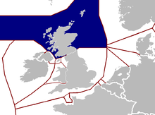 30A map of British Isles EEZs and surrounding nations. Internal UK borders are represented by thin lines.Scotland's EEZ is highlighted in blue.
Coastline
[
edit
]
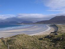 Large parts of the Scottish coastline are dune pasture, such as here at Traigh Seilebost on the
Isle of Harris
.
Large parts of the Scottish coastline are dune pasture, such as here at Traigh Seilebost on the
Isle of Harris
.
Mainland Scotland has 6,160 miles (9,910 km) of coastline. Including the numerous islands, this increases to some 11,602 miles (18,672 km).
[16]
The west coast in particular is heavily indented, with long promontories separated by
fjordlike
sea lochs
. The east coast is more regular, with a series of large estuarine inlets, or
firths
, and long sandy beaches, for example at
Aberdeen
. Parts of the Scottish coastline consist of a
machair formation
, a dune pasture land formed as sea levels subsided.
[17]
The east coast has several significant
estuaries
and is home to
nature reserves
including the
Ythan Estuary
and
Fowlsheugh
, both of which have been designated as
Important Bird Areas
.
Firths around the Scottish coast include the
Solway Firth
,
Firth of Clyde
, and
Firth of Lorne
on the west coast, and the
Cromarty Firth
,
Moray Firth
,
Firth of Tay
, and
Firth of Forth
on the east coast. The
Pentland Firth
is not an inlet, but the
strait
that separates the
Orkney Isles
from the mainland.
Major sea lochs include
Loch Fyne
,
Loch Long
,
Loch Ryan
,
Loch Linnhe
,
Loch Torridon
,
Loch Ewe
and, on the
Isle of Lewis
,
Loch Seaforth
.
Islands
[
edit
]
Scotland has over 900 islands, over 100 of which are inhabited.
[16]
Most of the islands are located off the northern and western coast of the country.
[18]
The
northern
and
western
islands of Scotland can be found in three main groups:
Shetland
,
Orkney
and the
Hebrides
which can be divided into the
Inner Hebrides
and the
Outer Hebrides
. Shetland and Orkney, together with
Fair Isle
and
Stroma
are referred to as the
Northern Isles
. With a total land area of 860 square miles (2,200 km
2
)
Lewis and Harris
(referred to as two islands but actually just one) is the largest Scottish island.
Many of these offshore islands are swept by strong tides, and the
Corryvreckan tide race
between
Scarba
and
Jura
is one of the largest
whirlpools
in the world. Other strong tides are to be found in the
Pentland Firth
between mainland Scotland and
Orkney
, and the
Grey Dog
between Scarba and
Lunga
. There are also numerous clusters of islands in the
Firth of Forth
and the
Firth of Clyde
and in freshwater lochs such as Loch Lomond and
Loch Maree
. Outlying islands include
St Kilda
and
Rockall
the status of which is disputed.
Scotland's islands have a varied topography.
Mull
,
Skye
and
Arran
are noted for their mountainous terrain, whilst
Tiree
and
Coll
are flat or low lying. Striking topographical differences can be seen within island groups themselves; in Orkney, the Island of
Hoy
is hillier and more rugged than surrounding islands and Harris is distinctive in being more mountainous than the islands of
Lewis
,
North Uist
,
South Uist
and
Barra
, in the Outer Hebrides.
Islay
's terrain is gentle and rolling; however, its neighbour
Jura
is mountainous and rugged.
Rum
and
Eigg
display jagged terrain; nearby
Canna
and
Muck
are flatter.
Rivers
[
edit
]
 The
estuary
of the
River Nith
emptying into the
Solway Firth
to the south of
Dumfries
.
The
estuary
of the
River Nith
emptying into the
Solway Firth
to the south of
Dumfries
.
The ten major rivers of Scotland, in order of length, are:
- River Tay
120 mi (190 km)
- River Spey
107 mi (172 km)
- River Clyde
106 mi (171 km)
- River Tweed
97 mi (156 km)
- River Dee
85 mi (137 km)
- River Don
82 mi (132 km)
- River Forth
65 mi (105 km)
- River Findhorn
63 mi (101 km)
- River Deveron
61 mi (98 km)
- River Annan
50 mi (80 km)
The
watershed
between river systems flowing west to the
Atlantic Ocean
and east into the
North Sea
is 745 mi (1,199 km) long.
[19]
Lochs
[
edit
]
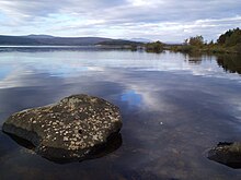 Loch Shin
is one of many freshwater bodies in Scotland.
Loch Shin
is one of many freshwater bodies in Scotland.
Fresh water
bodies in Scotland are known as
lochs
, with the exception of the
Lake of Menteith
and one or two-man-made "lakes". 90% of the standing fresh water volume of Great Britain lies within Scotland.
[20]
Loch Lomond
is the largest freshwater body in Britain by area, although with a capacity of 1.78 cubic miles (7.4 km
3
)
Loch Ness
is the most voluminous. The water in Loch Ness is nearly double that of all the lakes of England and Wales combined, and is by volume the largest lake in the UK and Ireland.
[21]
[22]
- Loch Lomond
27.5 sq mi (71 km
2
)
- Loch Ness
22.0 sq mi (57 km
2
)
- Loch Awe
15.0 sq mi (39 km
2
)
- Loch Maree
11.0 sq mi (28 km
2
)
- Loch Morar
10.3 sq mi (27 km
2
)
- Loch Tay
10.2 sq mi (26 km
2
)
- Loch Shin
8.7 sq mi (23 km
2
)
- Loch Shiel
7.6 sq mi (20 km
2
)
- Loch Rannoch
7.4 sq mi (19 km
2
)
- Loch Ericht
7.2 sq mi (19 km
2
)
Distances to other countries
[
edit
]
Scotland's only land border is with England, and runs for approximately 60 miles (100 kilometres) between the basin of the
River Tweed
on the east coast and the
Solway Firth
in the west. The
Atlantic Ocean
borders the west coast and the
North Sea
is to the east. The island of Ireland lies only 12 nautical miles (22 kilometres) from the southwestern peninsula of
Kintyre
;
[4]
Norway is 190 nmi (350 km) to the east; the
Faroes
, 170 nmi (310 km) to the north; and
Iceland
, 460 nmi (850 km) to the northwest.
Climate
[
edit
]
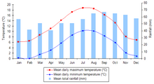 Climate graph for
Edinburgh
. Mild temperatures and evenly distributed rainfall, throughout the year, are characteristic of Scotland's
temperate
,
maritime climate
.
Climate graph for
Edinburgh
. Mild temperatures and evenly distributed rainfall, throughout the year, are characteristic of Scotland's
temperate
,
maritime climate
.
The climate of Scotland is
temperate
and very changeable, but rarely extreme.
[6]
Scotland is warmed by the
North Atlantic Drift
and given the northerly location of the country, experiences much milder conditions than areas on similar latitudes, such as
Labrador
in Canada?where
icebergs
are a common feature in winter.
[6]
Average temperatures are lower than in the rest of Great Britain, with the coldest ever UK temperature of ?27.2 °C (?17.0 °F) recorded at
Braemar
in the
Grampian Mountains
, on 10 January 1982 and also at
Altnaharra
,
Highland
, on 30 December 1995.
[6]
Winter maxima average 5.0 to 5.7 °C (41.0 to 42.3 °F), with summer maxima averaging 14.9 to 16.9 °C (58.8 to 62.4 °F).
[23]
Western coastal areas of Scotland are warmer than the east and inland areas, due to the influence of the Atlantic currents, and the colder surface temperatures of the
North Sea
; however, during rare hot spells, the west is cooler than the east.
[24]
The highest temperature recorded was 32.9 °C (91.2 °F) at
Greycrook
in the
Scottish Borders
on 9 August 2003.
[6]
Areas such as
Inverewe Garden
in the northwest and the
Logan Botanic Garden
in the southwest have warm enough microclimates to support palm trees.
Rainfall totals vary widely across Scotland?the western highlands of Scotland are one of the wettest places in the UK with annual rainfall up to 4,577 mm (180.2 in).
[25]
Due to the mountainous topography of the western Highlands, this type of precipitation is
orographic
in nature, with the warm, wet air forced to rise on contact with the mountainous coast, where it consequently, cools and
condenses
, forming clouds.
[26]
In comparison, much of eastern Scotland receives less than 870 mm (34.3 in) annually; lying in the
rain shadow
of the western uplands.
[25]
The town of
Dunbar
, east of Edinburgh, has an annual rainfall of merely 560.18 mm (22.05 in), less than
Barcelona
. Snowfall is less common in the lowlands, but becomes more common with altitude. Parts of the Highlands have an average of 36 to 60 snow days per year,
[27]
while some western coastal areas have between 0 and 6 days with snow a year.
[27]
Scotland's snowiest spot is the
Cairngorm
mountain range.
The Hebridean island of
Tiree
received a total of 329 hours of sunshine in May 1946 and again in May 1975, the highest number of sunshine hours ever recorded in one month in Scotland.
[6]
On the
longest day of the year
there is no complete darkness over the northern isles of Scotland.
Lerwick
, in Shetland, has four hours more daylight at midsummer than
London
, although this is reversed in midwinter.
[6]
Annual average sunshine totals vary from as little as 711–1140 hours in the Highlands and the north-west up to 1471–1540 hours on the extreme eastern and south-western coasts.
[28]
In common with the rest of the UK and Ireland, wind prevails from the south-west, bringing warm, wet and unstable air from the Atlantic.
[6]
The windiest areas of Scotland are in the north and west, with parts of the Outer Hebrides, Orkney and Shetland experiencing over 30 days with gales per year.
[6]
Vigorous Atlantic
depressions
, also known as
European windstorms
, are a common feature of the autumn and winter in Scotland.
[29]
Human geography
[
edit
]
 In northern and western areas, many people live in small crofting
townships
such as here on the
Isle of Skye
.
In northern and western areas, many people live in small crofting
townships
such as here on the
Isle of Skye
.
According to the
General Register Office for Scotland
, the total population of Scotland stood at 5,168,500 in June 2008, an increase of 2.1% since the
census
of April 2001.
[30]
Scotland's share of the United Kingdom population has been declining in recent years and stands at just over 8.5% due to differential rates of growth in the
home nations
.
[31]
However, an increasing
birth rate
[32]
and higher levels of inward migration to Scotland have reversed the decline and contributed to the recent population growth.
[30]
Compared with the rest of Europe, Scotland has a low
population density
at 65 people per square kilometre.
[33]
However Scotland is a highly
urbanised
country, with 82% of the population living in settlements of 3,000 people or more.
[34]
As a result, the majority of the population live in the
Central Lowlands
of Scotland, surrounding the chief cities of
Glasgow
and
Edinburgh
.
[35]
Other concentrations of population include the northeast coast of Scotland ? principally surrounding the city of
Aberdeen
and its environs ? and around
Inverness
.
[35]
With a population density of 8 people per square kilometre, the
Highlands
are the most sparsely populated part of the country, and one of the most sparsely populated areas in Europe. In these areas, the population is scattered in villages, small towns and isolated farmsteads or
crofts
.
[34]
 The city of
Inverness
is often regarded as the Capital of the Highlands
The city of
Inverness
is often regarded as the Capital of the Highlands
Nearly 100 of Scotland's islands are inhabited, the most populous being
Lewis and Harris
with 21,031 people resident in 2011, primarily concentrated around
Stornoway
, the only
burgh
of the
Outer Hebrides
.
[36]
[37]
Other island populations range down to very low levels on certain small isles.
[36]
Between 1991 and 2001, the total number of people living on Scotland's islands fell by 3%.
[36]
Conversely, islands such as
Tiree
,
Skye
and
Eigg
experienced increases in their respective populations over the same decade.
[36]
There are eight
cities
in Scotland; Glasgow, Edinburgh,
Aberdeen
,
Dundee
,
Inverness
,
Perth
,
Dunfermline
and
Stirling
. The 2001 census identified Glasgow as being the largest city in Scotland, with a total population of 629,501, while the Scottish
capital
, Edinburgh had a population of 448,624, in the same year.
[38]
Between 1991 and 2001, the populations of Edinburgh and Stirling grew by 2.9% and 6.5% respectively.
[38]
Inverness experienced population growth of over 10% during the same period.
[39]
At the same time, Glasgow, Dundee and Aberdeen all witnessed population decline.
[38]
Aside from the cities, the greatest intra-census population growth was experienced in the local authorities of
West Lothian
,
East Lothian
,
Aberdeenshire
and
Perth and Kinross
.
[38]
The Western Isles saw a 9.8% decrease in population between 1991 and 2001.
[38]
Political geography
[
edit
]
 The territorial extent of Scotland has been relatively unchanged since the late 15th Century.
The territorial extent of Scotland is generally that established by the 1237
Treaty of York
between Scotland and England
[40]
and the 1266
Treaty of Perth
between Scotland and Norway.
[41]
Exceptions include: the
Isle of Man
, which having been lost to England in the 14th century is now a
crown dependency
outside of the United Kingdom, the acquisition of
Orkney
and
Shetland
from Norway in 1472,
[42]
and the permanent recovery of
Berwick
by England in 1482.
[43]
Originally an independent country, Scotland joined with England to form the
Kingdom of Great Britain
in 1707 with the
Acts of Union
.
Between 1889 and 1975 Scotland was divided into
burghs
and
counties
, which were replaced by
regions and districts
. Since 1996, for the purposes of
local government
, Scotland has been divided into 32
council areas
.
Rockall
, a small and uninhabitable rocky islet in the North Atlantic, was annexed by the UK in 1955 and later declared part of Scotland by the
Island of Rockall Act 1972
.
[44]
[45]
However, the legality of this claim is disputed by the Republic of Ireland,
Denmark
and
Iceland
and it is probably unenforceable in international law.
[46]
[47]
As a
country of the United Kingdom
, Scotland is represented by Members of Parliament at the
Parliament of the United Kingdom
at
Westminster
,
London
. In 1997 a
referendum
was held, and the people of Scotland voted for the establishment of a
devolved
Scottish Parliament in Edinburgh. The new parliament has the power to govern the country on Scotland-specific matters and has a limited power to vary
income tax
. The United Kingdom Parliament retains responsibility for Scotland's
defence
,
international relations
and certain other areas. A
Scottish independence referendum
was held in September 2014, at which time independence was rejected.
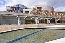 Scotland's capital city,
Edinburgh
, is home to the
Scottish Government
and
Scottish Parliament Building
Scotland's capital city,
Edinburgh
, is home to the
Scottish Government
and
Scottish Parliament Building
The latest election to the
Scottish Parliament
in
2021
concluded with the SNP winning a fourth consecutive term in government, winning 64 seats and an increase of one. The SNP gained
Edinburgh Central
,
Ayr
, and
East Lothian
as well as winning the largest share of the popular vote and the largest number of constituency seats in any Scottish Parliament election (62).
[48]
The Greens won 8 seats, their best result to date at a Scottish Parliament election, while the Conservatives retained second place with 31 seats. Labour had its worst-ever result with 22 seats, and the lowest share of the vote in both Constituency & List votes for either Westminster or Holyrood since 1910. The Lib Dems won four seats, their worst showing at a Holyrood election to date.
[49]
The SNP and the Greens, both of which support
Scottish independence
, won 72 of the 129 seats in the parliament. Unionist parties achieved a slight majority of votes in constituency contests, whilst pro-independence parties did the same in the regional list votes.
[50]
Voter turnout in the election reached 63.5%, the highest ever at a Scottish Parliament election. Following the election, the
third Sturgeon government
was formed, initially consisting of just the SNP but later including the appointment of Slater and Harvie as junior ministers, after the two parties negotiated a
power-sharing agreement
.
[51]
For centuries, a core aspect of Scotland's political geography has been the general divide between the
Highlands
and the
Lowlands
, a divide both physical and cultural. The physical geography of the divide (via the
Highland Boundary Fault
) and the political geography of the divide greatly overlap but are not identical. Despite any suggestiveness of the
etymons
"high" and "low", the division of Highlands and Lowlands does not
thoroughly
correspond either to
elevation
or to
latitude
in the sense of
Northern Scotland
and Southern Scotland being "upper" and "lower" (as north and south are often termed in various countries), and yet interestingly, the division does bear
some noticeable degree
of correspondence to both elevation and latitude, with upward and northward both
tending
toward stronger Highlander identity, more preservation of Gaelic versus Scots, and other political differentials (e.g., in previous centuries, degree of
Unionism
, degree of
Jacobitism
, and others).
[
original research?
]
Economic geography
[
edit
]
The nominal
gross domestic product
(GDP) of Scotland in 2023 was estimated to be £211.7 billion (US$290 billion)
[52]
including oil and gas extraction in Scottish waters. resulting a per capita GDP of approximately £38,622 per person.
[53]
Major industries include
banking and financial services
,
steelmaking
, transport equipment manufacturing,
oil and gas
,
agriculture
,
whisky distilling
, and
tourism
.
See also
[
edit
]
References
[
edit
]
- ^
"Standard Area Measurements (Latest) for Administrative Areas in the United Kingdom"
.
Open Geography Portal
. Office for National Statistics. 24 April 2024
. Retrieved
6 May
2024
.
- ^
"A Beginners Guide to UK Geography (2023)"
.
Open Geography Portal
. Office for National Statistics. 24 August 2023
. Retrieved
9 December
2023
.
- ^
"Scotland"
. Encyclopædia Britannica
. Retrieved
16 August
2007
.
- ^
a
b
Munro, D (1999).
Scotland Atlas and Gazetteer
. Harper Collins. pp. 1?2.
- ^
"
North Channel
", Encyclopædia Britannica. Retrieved 2 May 2016.
- ^
a
b
c
d
e
f
g
h
i
"Scottish climate"
.
Met Office
. 2001. Archived from
the original
on 27 May 2007
. Retrieved
20 August
2007
.
- ^
"Overview of Highland Boundary Fault"
. Gazetteer for Scotland, University of Edinburgh
. Retrieved
23 August
2007
.
- ^
a
b
"Loch Lomond to Stirling ? the Highland Line"
. Scottish Natural Heritage (SNH). Archived from
the original
on 17 February 2013
. Retrieved
23 August
2007
.
- ^
"Mid 2004 Localities estimates ? Localities in descending order of size"
(PDF)
. General Register of Scotland (GROS). 2004. Archived from
the original
(PDF)
on 27 September 2007
. Retrieved
23 August
2007
.
- ^
Lynch, M (2001), Industry to 1770s; pp211
Oxford Companion to Scottish History
- ^
Shepherd, Mike (2015).
Oil Strike North Sea: A first-hand history of North Sea oil
. Luath Press.
- ^
"A vision for the future of energy in Scotland"
.
Speech by the Minister for Enterprise, Energy and Tourism, Jim Mather
. Scottish Executive. 23 May 2007
. Retrieved
24 August
2007
.
[
permanent dead link
]
- ^
See
"The 'Where Are We' page"
Archived
17 November 2007 at the
Wayback Machine
highlandhostel.co.uk. Retrieved 22 September 2007.
- ^
National Statistics (2004).
UK 2005. The Official Yearbook of the United Kingdom of Great Britain and Northern Ireland
. London: The Stationery Office. p. 279.
ISBN
0-11-621738-3
.
- ^
a
b
c
d
"Mountains ? The Key Facts"
. Scottish Mountaineering Club. Archived from
the original
on 22 August 2012
. Retrieved
13 September
2009
.
- ^
a
b
"Facts and figures about Scotland's sea area (coastline length, sea area in sq kms)"
. Scottish Government
. Retrieved
2 November
2020
.
- ^
Machair Profile
Archived
20 May 2007 at the
Wayback Machine
- ^
"Scotland in Short"
(PDF)
. Scottish Executive. Archived from
the original
(PDF)
on 19 November 2013
. Retrieved
16 August
2007
.
- ^
BBC News online: Scotland's watershed route mapped out for hikers.
Includes map of the watershed. Retrieved 15 April 2011.
- ^
"Land Cover Change in Scotland"
Archived
25 February 2012 at the
Wayback Machine
. SNH. Retrieved 6 September 2009.
- ^
"Botanical survey of Scottish freshwater lochs"
Archived
3 March 2016 at the
Wayback Machine
SNH Information and Advisory Note Number 4. Retrieved 1 January 2010.
- ^
Murray and Pullar (1910)
"Lochs of the Ness Basin"
Pages 381-85, Volume II, Part II. National Library of Scotland. Retrieved 2 January 2010.
- ^
"Scotland 1971-2000 averages"
. Met Office. 2001. Archived from
the original
on 30 April 2004
. Retrieved
20 August
2007
.
- ^
"Mean Temperatures Annual Average"
. Met Office. 2001. Archived from
the original
on 3 January 2014
. Retrieved
20 August
2007
.
- ^
a
b
"Rainfall Amount Annual Average"
. Met Office. 2001. Archived from
the original
on 19 July 2013
. Retrieved
20 August
2007
.
- ^
Wheeler, Dennis; Mayes, Julian (1997).
Regional Climates of the British Isles
. Routledge.
ISBN
9780203437926
. Retrieved
21 August
2007
.
- ^
a
b
"Days of Snow Lying Annual Average"
. Met Office. 2001. Archived from
the original
on 9 August 2007
. Retrieved
20 August
2007
.
- ^
"Sunshine Duration Annual Average"
. Met Office. 2001. Archived from
the original
on 28 July 2014
. Retrieved
20 August
2007
.
- ^
"Lichens ? The Exceptional Scottish climate"
. Scottish National Heritage (SNH). 2001. Archived from
the original
on 13 August 2012
. Retrieved
21 August
2007
.
- ^
a
b
"Scotland's population continues to rise"
. General Register Office for Scotland. 28 April 2009. Archived from
the original
on 27 January 2010
. Retrieved
5 April
2010
.
- ^
"Population projections (2002 based)"
. General Register Office for Scotland. 24 March 2006. Archived from
the original
on 27 September 2007
. Retrieved
17 August
2007
.
- ^
"More births than deaths in 2006"
. General Register Office for Scotland. 6 March 2007. Archived from
the original
on 3 June 2007
. Retrieved
28 August
2007
.
- ^
"Population up for third consecutive year"
. General Register Office for Scotland. 27 April 2006. Archived from
the original
on 25 April 2007
. Retrieved
17 August
2007
.
- ^
a
b
"Review of Scotland's cities ? the analysis"
. Scottish Government. January 2003. Archived from
the original
on 2 September 2012
. Retrieved
17 August
2007
.
- ^
a
b
"A framework for maternity services in Scotland"
. Scottish Government. February 2001. Archived from
the original
on 30 September 2007
. Retrieved
17 August
2007
.
- ^
a
b
c
d
"Number of residents and households on all inhabited islands"
(PDF)
. General Register Office for Scotland. 28 November 2003. Archived from
the original
(PDF)
on 27 September 2007
. Retrieved
8 September
2007
.
- ^
"Statistical Bulletins | Scotland's Census"
.
scotlandscensus.gov.uk
. Retrieved
31 July
2019
.
- ^
a
b
c
d
e
"Revised Mid-year Population estimates ? 1982-2000"
. General Register Office for Scotland
. Retrieved
8 September
2007
.
[
dead link
]
- ^
Alistair Nicolson (19 March 2004).
"Scottish Economic Report March 2004 ? Demographic Change in the Highlands and Islands"
. Scottish Government. Archived from
the original
on 8 October 2012
. Retrieved
5 April
2010
.
- ^
"Uniting the Kingdoms?"
National Archives. Retrieved 21.11.06.
- ^
Mackie, J.D. (1969)
A History of Scotland
. London. Penguin.
- ^
Whitaker's Almanack
(1991) London. J. Whitaker and Sons.
- ^
Encyclopædia Britannica Online
Encyclopædia Britannica Online. Retrieved on 6 November 2007
- ^
"On this day ? 21 September"
BBC
. Retrieved 22 September 2007. "In 1972 the Isle of Rockall Act was passed, which made the rock officially part of Inverness-shire, Scotland."
- ^
"Daily Hansard"
24 June 1997. Parliament.uk. Retrieved 22 September 2007.
- ^
Oral Questions
Archived
22 August 2006 at the
Wayback Machine
to the Minister of Foreign Affairs in the
Dail Eireann
, 1 November 1973 Retrieved 17 January 2007.
- ^
MacDonald, Fraser (2006)
The last outpost of Empire: Rockall and the Cold War
. Journal of Historical Geography 32. P627?647.
available in pdf
Archived
18 February 2006 at the
Wayback Machine
- ^
Marlborough, Conor; Swanson, Ian (6 May 2021).
"Scottish election 2021: Will the SNP win a majority? Seven key questions the Scottish Parliament vote will answer"
.
MSN
.
Archived
from the original on 7 May 2021
. Retrieved
7 May
2021
.
- ^
"SNP win election one seat short of majority"
.
BBC News
. 8 May 2021.
Archived
from the original on 13 February 2022
. Retrieved
9 May
2021
.
- ^
Curtice, John (10 May 2021).
"Tactical vote reinforces Scotland's great divide"
.
The Times
.
Archived
from the original on 7 June 2021
. Retrieved
10 May
2021
.
- ^
"SNP and Greens agree new power-sharing deal"
.
BBC News
. 19 August 2021.
Archived
from the original on 24 August 2021
. Retrieved
19 August
2021
.
- ^
"GDP Quarterly National Accounts for Scotland:2023 Q2"
.
Gov.scot
. Retrieved
14 November
2023
.
- ^
"GDP Quarterly National Accounts: 2023 Quarter 2 (April to June)"
.
Scottish Government
. The Scottish Government
. Retrieved
9 December
2023
.
|
|---|
| Sovereign states
| |
|---|
States with limited
recognition
| |
|---|
Dependencies and
other entities
| |
|---|
| Other entities
| |
|---|