From Wikipedia, the free encyclopedia
Original file
(SVG file, nominally 683 × 683 pixels, file size: 929 KB)
??????
Summary
Licensing
I, the copyright holder of this work, hereby publish it under the following licenses:
- You are free:
- to share
? to copy, distribute and transmit the work
- to remix
? to adapt the work
- Under the following conditions:
- attribution
? You must give appropriate credit, provide a link to the license, and indicate if changes were made. You may do so in any reasonable manner, but not in any way that suggests the licensor endorses you or your use.
- share alike
? If you remix, transform, or build upon the material, you must distribute your contributions under the
same or compatible license
as the original.
https://creativecommons.org/licenses/by-sa/3.0
CC BY-SA 3.0
Creative Commons Attribution-Share Alike 3.0
true
true

|
Permission is granted to copy, distribute and/or modify this document under the terms of the
GNU Free Documentation License
, Version 1.2 or any later version published by the
Free Software Foundation
; with no Invariant Sections, no Front-Cover Texts, and no Back-Cover Texts. A copy of the license is included in the section entitled
GNU Free Documentation License
.
http://www.gnu.org/copyleft/fdl.html
GFDL
GNU Free Documentation License
true
true
|
You may select the license of your choice.
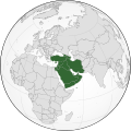
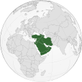
West Asia (orthographic projection)
Guneybatı Asya (Orta Do?u)
?????? ??????? ??????? ??????? ????? ????????? ???? ??? ???????
Западная Азия (орфографическая проекция)
File history
Click on a date/time to view the file as it appeared at that time.
| Date/Time
| Thumbnail
| Dimensions
| User
| Comment
|
|---|
| current
| 08:33, 5 September 2022
|  | 683 × 683
(929 KB)
| Рагин1987
| Final edit
|
| 12:01, 4 September 2022
|  | 683 × 683
(927 KB)
| Рагин1987
| Correction
|
| 18:50, 31 August 2022
|  | 2,048 × 2,048
(1.05 MB)
| Рагин1987
| Small correction
|
| 15:11, 31 August 2022
|  | 2,048 × 2,048
(1.05 MB)
| Рагин1987
| Small correction (Socotra Island is geologically closer to Africa)
|
| 18:45, 30 August 2022
|  | 2,048 × 2,048
(1.05 MB)
| Рагин1987
| More correct visualization of the dividing line on the territory of the Caucasus Range
|
| 14:21, 16 November 2019
|  | 683 × 683
(919 KB)
| Afrogindahood
| Fixed some border errors
|
| 13:05, 16 November 2019
|  | 512 × 512
(502 KB)
| Afrogindahood
| Fixed the gradient background not shown in the previous version
|
| 03:18, 31 October 2019
|  | 737 × 737
(834 KB)
| Afrogindahood
| Added Gaza Strip, Sinai Peninsula which is still part of Asia and removed Eastern Thrace which is part of Southeastern Europe
|
| 18:09, 11 May 2017
|  | 553 × 553
(332 KB)
| LouisAragon
| Rv disruption. 1 contradicted subdepartment means absolutely nothing.
|
| 14:28, 11 May 2017
|  | 590 × 590
(410 KB)
| Jcfidy
| Quito Iran [http://data.un.org/CountryProfile.aspx?crName=Iran%20%28Islamic%20Republic%20of%29 referencia]
|
File usage
The following pages on the English Wikipedia use this file (pages on other projects are not listed):
Global file usage
The following other wikis use this file:
- Usage on ab.wikipedia.org
- Usage on af.wikipedia.org
- Usage on ar.wikipedia.org
- Usage on ast.wikipedia.org
- Usage on av.wikipedia.org
- Usage on azb.wikipedia.org
- Usage on ba.wikipedia.org
- Usage on be.wikipedia.org
- Usage on bg.wikipedia.org
- Usage on bn.wikipedia.org
- Usage on br.wikipedia.org
- Usage on bs.wikipedia.org
- Usage on bxr.wikipedia.org
- Usage on ca.wikipedia.org
- Usage on cdo.wikipedia.org
- Usage on cs.wikipedia.org
- Usage on cv.wikipedia.org
- Usage on cy.wikipedia.org
- Usage on da.wikipedia.org
- Usage on de.wikipedia.org
- Usage on de.wiktionary.org
- Usage on diq.wikipedia.org
- Usage on el.wikipedia.org
- Usage on en.wiktionary.org
- Usage on eo.wikipedia.org
- Usage on es.wikipedia.org
- Usage on et.wikipedia.org
- Usage on eu.wikipedia.org
- Usage on fa.wikipedia.org
- Usage on fi.wikipedia.org
- Usage on frr.wikipedia.org
- Usage on fr.wikipedia.org
View
more global usage
of this file.
This file contains additional information, probably added from the digital camera or scanner used to create or digitize it.
If the file has been modified from its original state, some details may not fully reflect the modified file.
