Largest and easternmost canton of Switzerland
Canton
Grisons
Graubunden
|
|---|
|
Canton of the Grisons
Canton of Graubunden
|
 Flag
 Coat of arms
|
 |
| Coordinates:
46°45′N
9°30′E
/
46.750°N 9.500°E
/
46.750; 9.500
|
| Capital
| Chur
|
|---|
| Subdivisions
| 108 municipalities
,
11 districts
|
|---|
|
| ?
Executive
| Executive Council
(5)
|
|---|
| ?
Legislative
| Grand Council
(120)
|
|---|
|
| ? Total
| 7,105.39 km
2
(2,743.41 sq mi)
|
|---|
|
| ? Total
| 200,096
|
|---|
| ? Density
| 28/km
2
(73/sq mi)
|
|---|
|
| ? Total
| CHF
14.519 billion (2020)
|
|---|
| ? Per capita
| CHF 72,754 (2020)
|
|---|
| ISO 3166 code
| CH-GR
|
|---|
| Highest point
| 4,049 m (13,284 ft):
Piz Bernina
|
|---|
| Lowest point
| 260 m (853 ft): border to
Ticino
at
San Vittore
|
|---|
| Joined
| 1803
|
|---|
| Languages
| German
,
Romansh
,
Italian
|
|---|
| Other languages
| Lombard
,
Walser german
|
|---|
| Website
| www
.gr
.ch
/IT
/Seiten
/welcome
.aspx
|
|---|
The
Grisons
(
,
[4]
French:
[??iz??]
) or
Graubunden
(
German:
[?ra??b?ndn?]
ⓘ
),
[note 1]
more formally the
Canton of the Grisons
or the
Canton of Graubunden
,
[5]
is one of the twenty-six
cantons
of
Switzerland
. It has eleven districts, and its capital is
Chur
. The
German
name of the canton,
Graubunden
, translates as the "Grey Leagues", referring to the canton's origin in three local alliances, the
Three Leagues
. The other native names also refer to the
Grey League
:
Grischun
in
Sutsilvan
,
Grischun
in the other forms of
Romansh
, and
Grigioni
in
Italian
.
Rhaetia
is the Latin name for the area. The
Alpine ibex
is the canton's heraldic symbol.
The largest and easternmost canton of Switzerland, it is also one of the three large southern
Alpine
cantons, along with
Valais
and
Ticino
. It is the most diverse canton in terms of natural and cultural geography, as it encompasses both sides of the Alps and several natural and cultural regions. The diversity of the canton is often compared to that of Switzerland as a whole and warrants it the name of "Little Switzerland".
[6]
[7]
The Grisons is bordered by four cantons as well as
Austria
,
Italy
and
Liechtenstein
.
The state is the only trilingual canton of Switzerland.
[8]
It is also the only one where
Romansh
, Switzerland's fourth national language, has official status. Romansh language and culture is an important part of local identity.
[9]
In 2020 the canton had a population of 200,096.
[2]
It is the least densely populated canton of Switzerland. The only sizable city in the canton is Chur, as the majority of the population lives in mountainous areas, including some of the most remote valleys of the country. One of the birthplaces of winter sports, the canton is a major tourist destination year-round, including a large number of Alpine resort towns, notably
Davos
and
St. Moritz
. The canton is also renowned for its extensive narrow-gauge railway network, operated by the
Rhaetian Railway
, and linking the capital with most valleys of the Grisons.
Formerly occupied by the
Rhaeti
, most of the lands of the canton became part of the Roman province called
Raetia
, which was established in 15 BC, with
Curia
, a settlement dating back to the
Pfyn culture
, as capital city. The area later became part of the lands of the
diocese of Chur
. The late middle ages saw the foundation of the
League of God's House
, the
Grey League
and the
League of the Ten Jurisdictions
. In 1471 an alliance gave birth to the
Three Leagues
, and before the end of the 15th century, the latter became an ally of the
Old Swiss Confederacy
. In 1803 the Three Leagues finally became one of the cantons of the Confederation.
Geography and climate
[
edit
]
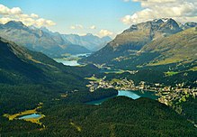 The Engadin (here near
St. Moritz
and the lakes) is one of the highest valleys of the Alps and the only Swiss region in the basin of the Black Sea.
The Engadin (here near
St. Moritz
and the lakes) is one of the highest valleys of the Alps and the only Swiss region in the basin of the Black Sea.
The Grisons is Switzerland's largest and at the same time easternmost canton. Its geography, essentially marked by the
Alps
, is complex and encompasses a wide range of climates and ecosystems. It is one of the three large southern Alpine cantons, along with
Ticino
and
Valais
, which include regions on the south side of the Alps. But in contrast to those (and all other cantons), it fully extends on both sides of the great Alpine barrier, from the northern plains at
Maienfeld
to the southern plains at
Roveredo
. However, a large portion of the canton is neither clearly north nor south of the Alps, it is the
Engadin
(the "garden of the Inn"), a large inner Alpine valley oriented towards eastern Europe. Therefore there are parts of this canton in four of the
five drainage basins of the country
. The north of the canton is drained by the
Rhine
(ending in the North Sea), the south by the
Po
and
Adige
through several affluents (Mediterranean Sea), and the Engadin by the
Danube
through the
Inn
(Black Sea).
[10]
The Grisons lies fully within the Alps, with elevations above sea-level ranging from 260 to 4,049 metres (853 to 13,284 ft). It is
both one of the highest and lowest cantons
, and the second-highest when considering mean elevation. As a consequence, its topography is extremely rugged and many of the highest settlements in the country (and Europe) are found there, notably in the Upper Engadin. The mountains are numerous; well over 1,000 summits are in the canton.
[11]
The highest is
Piz Bernina
, closely followed by numerous peaks in the
homonymous range
. Other prominent mountains are
Piz Russein
,
Piz Kesch
,
Calanda
,
Aroser Rothorn
and
Rheinwaldhorn
, see
list of mountains of Graubunden
for a more exhaustive list. The canton includes numerous subranges of the Alps other than the Bernina. These are the
Albula
, the
Bregaglia
, the
Glarus
, the
Gotthard
, the
Lepontine
, the
Livigno
, the
Plessur
, the
Oberhalbstein
, the
Ortler
, the
Ratikon
, the
Samnaun
, the
Sesvenna
and the
Silvretta
ranges.
 The
Anterior Rhine
(here at the
Rhine Gorge
) is one of the largest rivers in the canton.
The
Anterior Rhine
(here at the
Rhine Gorge
) is one of the largest rivers in the canton.
The regions on the north side of the Alps are all drained by the Rhine and form an intricate network of valleys. The Rhine is both one of the longest rivers within the canton and the only one flowing directly into a sea. The
sources of the Rhine
are found in the west of the canton and form the
Anterior Rhine
and the
Posterior Rhine
. These two rivers converge at
Reichenau
to form the Rhine in the strict sense of the term. Just after the convergence, the valley opens and its floor constitutes the flattest plains of the canton, from
Domat/Ems
to
Flasch
at the St. Gallen border. In the area around
Chur
, at the foot of the
Calanda
, the Rhine progressively changes its direction, from eastward to northward. The Anterior Rhine and Posterior Rhine include numerous tributaries as well before their own convergence. The former constitutes a long and straight valley, the Surselva, shut off from the lower plains by the
Rhine Gorge
. Its biggest tributaries are the rivers
Glogn
,
Valser Rhine
,
Rabiusa
, forming respectively the
Val Lumnezia
, the
Vals Valley
and the
Safiental
. The other one, the Posterior Rhine, notably collects the waters of the
Avers Rhine
and the
Albula
, which in turn collects the waters of the
Gelgia
and the
Landwasser
. Similarly to the Anterior Rhine, the upper portion of the Posterior Rhine is also shut off from the plains by the
Viamala
Gorge. After the convergence with the Albula, the Posterior Rhine forms a wide valley, the
Domleschg
, until it meets its anterior counterpart. After that, the Rhine collects the water of two important rivers: the
Plessur
at Chur, forming the valley of the
Schanfigg
, and the
Landquart
at the
homonymous town
, forming the
Pratigau
.
[10]
The Engadin is entirely drained by the Inn and is the only valley in Switzerland in the Danube basin. The Inn is one of the longest rivers in the canton and forms an almost straight valley, from the
Maloja Pass
to
Martina
, with a change of direction near
Zernez
. Despite its length and numerous tributaries, only a few long rivers converge with the Inn. These are the
Flaz
(forming the Val Bernina), the
Spol
(forming the Val da Spol) and the Clemgia (forming the
Val S-charl
). In the lower part of the Engadin is also the side valley of
Samnaun
. The main passes connecting the Engadin with the northern Grisons are (from west to east): the
Julier Pass
, the
Albula Pass
and the
Fluela Pass
.
[10]
The valleys on the south side of the Alps are not contiguous to each other and form four distinct regions. The
Mesolcina
, drained by the
Moesa
, the
Val Bregaglia
, drained by the
Mera
, the
Val Poschiavo
, drained by the
Poschiavino
, and the
Val Mustair
, drained by the
Rom
. The first three are in the Po basin and the last one is in the Adige basin. While the first two (Mesolcina and Bregaglia) are contiguous to the region north of the Alps, through the
San Bernardino Pass
, and the
Septimer Pass
respectively, the three last ones (Bregaglia, Poschiavo and Mustair) are contiguous to the Engadin, through the
Maloja Pass
, the
Bernina Pass
, and the
Ofen Pass
.
[10]
Although no large bodies of water are found in the canton, numerous mountain lakes (above 800 m elevation) dot the landscape, some of them being used as reservoirs for hydroelectricity production. The largest natural lakes are
Lake Sils
,
Lake Silvaplana
,
Lago di Poschiavo
and
Lake St. Moritz
(all in Upper Engadin except that of Poschiavo). Artificial lakes are more numerous, the largest (over 100 ha) being
Lago di Livigno
,
Lago di Lei
,
Lai da Sontga Maria
,
Zervreilasee
,
Lago Bianco
,
Lai da Marmorera
and
Lagh da l'Albigna
. The total number of lakes has been estimated to 600.
[12]
See
list of mountain lakes of Switzerland
for a more exhaustive list.
Unlike other large cantons, the Grisons includes very few cities. The largest (and capital city) is
Chur
. It is followed by
Davos
,
Landquart
,
Domat/Ems
and
St. Moritz
, which are, however, far less populated. The canton is particularly renowned for its numerous Alpine resort towns, notably two of the aforementioned ones (Davos and St. Moritz), but also
Klosters
,
Arosa
,
Lenzerheide
,
Disentis
,
Flims
,
Pontresina
and
Scuol
.
[13]
The diversity of the climate of the Grisons is high and comparable to
that of Switzerland
. In the southernmost and lowest regions, vineyards and olives are grown,
[14]
while on the highest summits, snow is found year-round. The inner valleys, particularly the Engadin, are significantly drier than the north and south side of the Alps, being sheltered by the high mountains of the range. On the south side of the Alps,
Grono
is one of the top warmest places in the country with an average of 12.4 °C (54.3 °F). The nationwide record temperature of 41.5 °C (106.7 °F) was registered there. The southern valleys are also significantly wetter than the rest of the canton (1,476 mm of rain in Grono, 849 mm in Chur, and 705 mm in Scuol). The coldest places are naturally at high elevations, such as on
Piz Corvatsch
. The localities of the Upper Engadin are amongst the coldest inhabited regions in the country, notably
Samedan
with an average temperature of 2.0 °C (35.6 °F). The cantonwide record-low temperature of ?37.9 °C (?36.2 °F) was registered there.
[15]
The low-elevation region of Chur, including the Bundner Herrschaft, experiences naturally less harsh temperatures with an average of 10.0 °C (50.0 °F).
-
Lowlands: Vineyards of the Bundner Herrschaft, at the foot of the
Falknis
-
Montane zone: Val Bregaglia, at the foot of
Piz Badile
-
Alpine zone: Val Frisal, at the foot of
Piz Durschin
-
The area of the Grisons is 7,105.2 square kilometres (2,743.3 sq mi), 19.2% larger than the
canton of Bern
, the second largest canton.
[16]
Only about a third of this is commonly regarded as productive land of which
forests
cover about a fifth of the total area.
[16]
The canton is almost entirely mountainous and it is the most sparsely populated region of the country. In its southeastern part lies the only official
Swiss National Park
. In its northern part, the mountains were formed as part of the thrust fault that was in 2008 declared a geologic
UNESCO
World Heritage Site
, under the name
Swiss Tectonic Arena Sardona
. Another
Biosphere Reserve
is the
Biosfera Val Mustair
adjacent to the Swiss National Park, while
Ela Nature Park
is one of the regionally supported parks.
The Grisons is sometimes included in the larger region of
Eastern Switzerland
, together with six other cantons. The Grisons shares border with numerous regions of Europe, reflecting its cultural diversity, and is the only canton adjacent to three different countries. On the national level it shares borders with four other cantons:
Uri
,
Glarus
,
St. Gallen
to the northwest (essentially across the Glarus Alps) and
Ticino
to the west (essentially across the
Gotthard Massif
and the Lepontine Alps but also at the level of the plain at Roveredo). On the international level, the canton shares borders with three countries:
Liechtenstein
to the north, the Austrian regions of
Vorarlberg
and
Tyrol
to the northeast and the Italian regions of
Trentino-South Tyrol
and
Lombardy
to the east and south.
[17]
History
[
edit
]
 Map of the
Three Leagues
and surrounding lands
Map of the
Three Leagues
and surrounding lands
The deep Alpine valleys of the present-day Grisons were originally settled by the
Raetians
(
Rhaeti
). In Chur, archaeological evidence of settlement goes back as far as the
Pfyn culture
[18]
(3900?3500 BC),
[19]
making the capital city of the Grisons one of the oldest settlements in Switzerland.
Most of the lands of the canton were once part of a Roman province called
Raetia
, which was established in 15 BC. The current capital of the Grisons,
Chur
, was known as Curia in Roman times. The area later was part of the lands of the
diocese of Chur
.
In 1367 the
League of God's House
(
Cadi
,
Gottes Haus
,
Ca' di Dio
) was founded to resist the rising power of the
Bishop of Chur
. This was followed by the establishment of the
Grey League
(
Grauer Bund
), sometimes called
Oberbund
, in 1395 in the Upper Rhine valley. The name
Grey League
is derived from the homespun grey clothes worn by the people and was used exclusively after 16 March 1424.
[20]
The name of this league later gave its name to the canton of the Grisons. A third league was established in 1436 by the people of ten
bailiwicks
in the former
Toggenburg countship
, as the dynasty of Toggenburg had become extinct. The league was called
League of the Ten Jurisdictions
(
Zehngerichtebund
).
 The Dreibundenstein monument, marking the former tripoint of the Three Leagues
The first step towards the canton of the Grisons was when the league of the Ten Jurisdictions allied with the League of God's House in 1450. In 1471 the two leagues allied with the Grey League. In 1497 and 1498 the Leagues
[21]
allied with the
Old Swiss Confederacy
after the
Habsburgs
acquired the possessions of the extinct Toggenburg dynasty in 1496,
[22]
siding with the Confederacy in the
Swabian War
three years later. The Habsburgs were defeated at
Calven Gorge
and
Dornach
, helping the Swiss Confederation and the allied leagues of the canton of the Grisons to be recognised. However the
Three Leagues
remained a loose association until the
Bundesbrief
of 23 September 1524.
[23]
The last traces of the Bishop of Chur's jurisdiction were abolished in 1526. The
Musso war
of 1520 drove the Three Leagues closer to the Swiss Confederacy.
Between 1618 and 1639 it became a battleground between competing factions during the
Bundner Wirren
. The
Protestant
party was supported by
France
and
Venice
, while the
Catholic
party was supported by the
Habsburgs
in Spain and Austria. Each side sought to gain control of the Grisons to gain control over the important
alpine
passes. In 1618, the young radical
Jorg Jenatsch
became a member of the court of 'clerical overseers' and a leader of the anti-Habsburg faction. He supervised the torture to death of the arch-priest Nicola Rusca of
Sondrio
. In response, Giacomo Robustelli of the pro-Catholic Planta family, raised an army of rebels in the
Valtellina
. On the evening of 18/19 July 1620, a force of Valtellina rebels supported by Austrian and Italian troops marched into
Tirano
and began killing Protestants. When they finished in Tirano, they marched to
Teglio
,
Sondrio
and further down the valley killing every Protestant that they found. Between 500
[24]
and 600
[25]
people were killed on that night and in the following four days. The attack drove nearly all the Protestants out of the valley, prevented further Protestant incursions and took the Valtellina out of the Three Leagues.
 Jorg Jenatsch
was a major and divisive figure during the
Bundner Wirren
(1618?1639).
Jorg Jenatsch
was a major and divisive figure during the
Bundner Wirren
(1618?1639).
In response, in February 1621, Jenatsch led a force of anti-Habsburg troops to attack
Rietberg Castle
, the home of a leader of the pro-Catholic faction, Pompeius Planta.
[26]
They surprised Planta and according to legend he was killed by Jorg Jenatsch with an axe.
[27]
The murder of Planta encouraged the Protestant faction and they assembled a poorly led and disorganized army to retake the Valtellina and other subject lands. However, the army fell apart before they could attack a single Catholic town.
[26]
This Protestant invasion provided the Spanish and Austrians with an excuse to invade the Leagues. By the end of October, Spain and Austria had occupied all of the Grisons. The resulting peace treaty of January 1622, forced Grisons to cede the
Mustair
, the
Lower Engadine
and
Prattigau
valleys.
[24]
The treaty also forbade the Protestant religion in these valleys. In response, in 1622, the Prattigau valley rebelled against the Austrians and drove them out of the valley. The Austrians invaded the valley twice more, attempting to reimpose the Catholic faith, in 1623?1624 and 1629?1631.
[28]
In 1623 the Leagues entered into an alliance with France, Savoy and Venice. Jurg Jenatsch and Ulysses von Salis used French money to hire an 8,000-man mercenary army and drive out the Austrians. The peace treaty of Monzon (5 March 1626) between France and Spain, confirmed the political and religious independence of the Valtellina. In 1627 the French withdrew from the Valtellina valley, which was then occupied by Papal troops. Starting in 1631 the League, under the French Duke Henri de Rohan, started to expel the Spaniards. However, Richelieu still did not want to hand the valley over to its residents. When it became clear that the French intended to remain permanently in the Leagues, but would not force the Valtellina to convert to Protestantism, Jurg Jenatsch (now a mercenary leader) converted in 1635 to the Catholic faith. In 1637, he rebelled and allied with Austria and Spain. His rebellion along with the rebellion of 31 other League officers forced the French to withdraw without a fight.
[24]
[28]
On 24 January 1639, Jurg Jenatsch was killed during
Carnival
by an unknown attacker who was dressed as a bear. The attacker may have been a son of Pompeius Planta
[24]
or an assassin hired by the local aristocracy.
[28]
According to legend he was killed by the same axe that he used on Pompeius Planta.
[27]
On 3 September 1639 the Leagues agreed with Spain to bring the Valtellina back under League sovereignty, but with the promise to respect the free exercise of the Catholic faith. Treaties with Austria in 1649 and 1652, brought the Mustair and Lower Engadine valleys back under the authority of the Three Leagues.
[24]
In 1798, the lands of the canton of the Grisons became part of the
Helvetic Republic
as the
canton of Raetia
except
Valtellina
, which was separated in 1797 for joining the
Cisalpine Republic
. It was later part of the
Empire of Austria
in 1814 before joining the
Kingdom of Italy
in 1859. With the
Act of Mediation
the "perpetual ally" of
Switzerland
became a canton in 1803. The constitution of the canton dates from 1892. In the following century, there have been about 30 changes made to the constitution.
[29]
The arms of the three original leagues were combined into the modern
cantonal coat of arms
in 1933.
Government
[
edit
]
 Grand Council building in Chur
The Grand Council (
German
:
Grosser Rat
;
Italian
:
Gran Consiglio
,
Romansh
:
Cussegl Grond
), the legislature of the canton, sits in Chur, the cantonal capital. Its 120 members, elected in 39 districts using a
majority system
, are in office for four years. The last district elections were in 2014.
[30]
The cantonal government, exercising executive authority, is made up of five members, elected by the people for a term of four years and
limited
to three terms using a
majority system
.
[31]
The constitution of the Grisons, last revised on 14 September 2003, states in its
preamble
that the canton's purpose is to "safeguard freedom, peace, and human dignity, ensure democracy and the
Rechtsstaat
, promote prosperity and
social justice
and preserving a sane environment for the future generations, with the intention of promoting
trilingualism
and cultural variety and conserving them as part of our historical heritage".
[32]
The constitution allows for the
enfranchisement of foreign residents
at a municipal level, at discretion of the local governments. In 2009, the municipality of
Bregaglia
became the first in the canton to make use of this provision, granting voting rights to foreigners.
[33]
Politics
[
edit
]
Federal election results
[
edit
]
- ^a
FDP before 2009, FDP.The Liberals after 2009
- ^b
"*" indicates that the party was not on the ballot in this canton.
Political subdivisions
[
edit
]
Regions
[
edit
]
as of January 2017
[35]
Municipalities
[
edit
]
There are 114
municipalities in the canton
(as of January 2016
[update]
).
[36]
Demographics
[
edit
]
 View of Chur, at the foot of the
Calanda
View of Chur, at the foot of the
Calanda
The inhabitants of the Grisons are called
Bundner
or (rarely) Grisonians.
[
citation needed
]
The population of the canton (as of 31 December 2020) is 200,096.
[2]
As of 2007
[update]
, the population included 28,008 foreigners, or about 14.84% of the total population.
[37]
The main religions are
Catholicism
and
Protestantism
. Both are well represented in the canton, with Roman Catholics forming a slight plurality (47% Catholic to 41% Protestant).
[38]
Languages
[
edit
]
 Geographical distribution of languages in the Grisons as of 2000
[update]
Geographical distribution of languages in the Grisons as of 2000
[update]
The Grisons is the only canton of Switzerland with three official languages:
German
(74.7%),
Romansh
(13.9%), and
Italian
(13.9%) with the remaining 13% speaking another language natively.
[39]
[40]
Languages in the Grisons 1803?2020
[41]
[42]
| Year
|
Population
|
Romansh (%)
|
German (%)
|
Italian (%)
|
| 1803
|
73,200
[43]
|
36,700 (~
50%
)
|
26,500 (~36%)
|
10,000 (~14%)
|
| 1850
|
89,895
|
42,439 (47.2%)
|
35,509 (39.5%)
|
11,956 (13.3%)
|
| 1880
|
93,864
|
37,794 (39.8%)
|
43,664 (46.0%)
|
12,976 (13.7%)
|
| 1900
|
104,520
|
36,472 (34.9%)
|
48,762 (46.7%)
|
17,539 (16.8%)
|
| 1920
|
119,854
|
39,127 (32.7%)
|
61,379 (51.2%)
|
17,674 (14.8%)
|
| 1941
|
128,247
|
40,187 (31.3%)
|
70,421 (54.9%)
|
16,438 (12.8%)
|
| 1950
|
137,100
|
40,109 (29.3%)
|
77,096 (56.2%)
|
18,079 (13.2%)
|
| 1960
|
147,458
|
38,414 (26.1%)
|
83,544 (56.7%)
|
23,682 (16.1%)
|
| 1970
|
162,086
|
37,878 (23.4%)
|
93,359 (57.6%)
|
25,575 (15.8%)
|
| 1980
|
164,641
|
36,017 (21.9%)
|
98,645 (59.9%)
|
22,199 (13.5%)
|
| 2000
|
187,058
|
27,038 (14.5%)
|
127,755 (68.3%)
|
19,106 (10.2%)
|
| 2012
|
191,612
|
27,955 (15.2%)
|
143,015 (74.6%)
|
23,506 (12.0%)
|
| 2015
[44]
|
193,662
|
29,826 (15.4%)
|
142,378 (73.5%)
|
25,033 (12.9%)
|
| 2020
|
200,096
|
27,813 (13.9%)
|
149,471 (74.7%)
|
27,813 (13.9%)
|
More speakers of the
Romansh language
live in the Grisons than in any other canton, although it has become a minority language there. Romansh consists of five dialect groups, each with its own written language:
Sursilvan
,
Vallader
,
Puter
,
Surmiran
and
Sutsilvan
. There also exists a common written language called
Rumantsch Grischun
.
Romansh has been recognized as one of four "national languages" by the
Swiss Federal Constitution
since 1938. It was declared an "official language" of the Confederation in 1996, meaning that Romansh speakers may use Romansh for correspondence with the federal government and expect to receive a response in Rumantsch Grischun.
Romansh has official language status at the canton level. Municipalities in turn are free to specify their own official languages.
Economy
[
edit
]
 Skiers above
Lenzerheide
Skiers above
Lenzerheide
Agriculture is still essential to keep remote valleys inhabited and
cultivated
, differing it from sheer
wilderness
. Agriculture is therefore supported by subsidies by the authorities both national and regional. Eight per cent of the population work in agriculture and forestry, where 50 per cent of the production is certified as organic. Agriculture includes forests and
mountain pasturage
in summer, particularly of cows, sheep and goats.
[
citation needed
]
Since wolf and bear have returned, the use of
Maremma Sheepdogs
is not unusual.
[45]
Although mountain pastures are predominant, there is also wine production in the Rhine Valley, particularly in
Flasch
,
Maienfeld
,
Jenins
and
Malans
. This area is referred to as the Bundner Herschaft. In the southern valleys of
Mesolcina
and
Val Poschiavo
there is corn (
maize
) and
chestnut farming
, allowed by the milder climate. In the Mesolcina,
olive trees are also grown
.
[14]
24 per cent of the workforce are employed in industry whereas 68 per cent work in the service industry. The most industrialized region is naturally that of Chur.
Ems-Chemie
is based in
Domat/Ems
and is a major employer in the area.
The tourism industry is a major player and reaches a remarkable 14 per cent of the GDP. Tourism is concentrated around the towns of
Davos
,
Klosters
,
Lenzerheide
,
Arosa
,
Flims
,
St. Moritz
and
Pontresina
, which have large ski areas. There are, however, a great number of other tourist resorts in the canton, divided by the official tourist board for winter sports for example into categories "Top - Large - Small and beautiful".
[46]
St. Moritz is one of the oldest
winter sport
resorts, being popular in winter since 1864.
[47]
[48]
The following year, Davos also saw its first tourists in winter.
[49]
St. Moritz hosted the
1928 Winter Olympics
and the
1948 Winter Olympics
. Summer tourism is also an important source of revenue. Trekking, mountaineering, and mountain biking are some of the main activities. Business tourism is also a source of revenue, notably in
Davos
, where the
World Economic Forum
meetings are traditionally organised.
Transport
[
edit
]
 Glacier Express
climbing the
Albula Railway
. Winding mountain roads and railways have become an integral part of the landscape.
Glacier Express
climbing the
Albula Railway
. Winding mountain roads and railways have become an integral part of the landscape.
As the canton extends on both sides of the great Alpine barrier, many important mountain passes are found there, particularly on the north-south axis. Transport has always been an important issue in the area; cart tracks from the Roman era were found on
Julier Pass
and
Septimer Pass
was rebuilt for cart use in 1387 and, although it later became unimportant, it is still in its 1800 form (for hikers only).
Corniche
paths were necessary for long stretches, and gorges such as the
Viamala
gave construction problems for any kind of transport. The first real roads of 3.7 m (4 yd) width were built across the Alps from around 1816, one of which is still in a very good historical condition
[50]
as this connection across
Splugen Pass
lost its importance after the opening of rail tunnels crossing the alps. The last valley to be connected to the road system in the Grisons was
Avers
, whose remote hamlet of
Juf
was only reached in 1897. After the
Swiss Post
expanded their
Postal Bus
transport services, the region's inhabitants became more used to motorized traffic.
[51]
In 1925, there were already 250 vehicles in service.
[51]
Eventually, the inhabitants of the Grisons gave up their resistance against individual motor traffic in 1926,
[52]
In 1967 opened
San Bernardino road tunnel
, built to host tourism traffic, is used also by heavy goods vehicles nowadays although not really suitable for them because of its ascent gradients. Most other passes have lost their importance for goods transport nowadays.
Unlike
Valais
and
Ticino
, the Grisons does not benefit from major railway axes across the Alps such as the
Lotschberg
and
Gotthard
. As a consequence, the only standard gauge railway in the canton is that of the Rhine Valley, ending at
Chur station
. Conversely, the latter has become a major railway station and a transport hub of the canton since the construction of the
Rhaetian Railway
, which links most regions of the canton from the Rhine Valley.
Huge efforts ensure public transport to (nearly) every settlement by an integrated timetable of different transport companies. Even Juf, inhabited by some 30 people only but holding a
European record
, is reached five times a day by public transport. The two main transport companies are
PostBus
, the national post bus company, and the Rhaetian Railway, essentially owned by the cantonal government. The latter uses the largest narrow-gauge railway network in Switzerland and serves most regions of the canton, with branches towards Central Switzerland and Italy. This network is notably travelled by two of the longest distance trains of Switzerland: the
Glacier Express
and the
Bernina Express
. The
Swiss Federal Railways
extend only a few kilometres into the canton, from Maienfeld, and serve essentially
Landquart
and Chur, where passengers transfer to the Rhaetian Railway and a large number of PostBus routes. The
Albula Line
became a UNESCO world heritage as did the
Bernina Railway
, the highest and only railway to cross the Alps without the use of a tunnel at the pass. In winter some of the road passes are closed
[53]
whereas several high mountain passes such as the
Julier
,
Bernina
and
Lukmanier
are kept open all winter (subject to restrictions). Being the highest elevated state in Switzerland, the Grisons hosts huge alpine areas that are not accessible by any means of transport but have to be walked to.
[54]
A large number of cable transport facilities provide easy access to some of the mountains of the Grisons, the highest being on
Piz Corvatsch
.
The
Engadin
valley has its own airport,
Samedan Airport
. It is the highest airport in Switzerland.
Culture
[
edit
]
 Painted houses in
Guarda
Painted houses in
Guarda
The Grisons is culturally the most diverse region of Switzerland. Its common denominator, however, is a strong mountain culture marked by life in isolated rural communities, notably depicted in
Johanna Spyri
's
Heidi
. Traditional customs include
Alpine transhumance
in spring and autumn, and the
Chalandamarz
at the end of winter.
The canton has a large concentration of medieval castles (and ruins). The most notable, in the Engadin, is that of
Tarasp
, guarding the Inn valley. Many ruins and castles are found in the
Domleschg
area. Close by lies the church of
Zillis
, where 1130/40 a famous romanesque illustrated ceiling was added which is now treated as national heritage. Three
World Heritage Sites
are located in the canton: the
Benedictine Convent of Saint John
, the
Swiss Tectonic Arena Sardona
and the
Rhaetian Railway
in the
Albula
and
Bernina
Landscapes.
 A dish of
Maluns
accompanied by various products of the Grisons
A dish of
Maluns
accompanied by various products of the Grisons
The gastronomy of the Grisons is mostly known for a dried-beef delicacy called
Bundnerfleisch
, often simply referred to as Grisons Meat. Other meat specialities include dried sausages (especially
Salsiz
, made of various meats), speck and ham. Cheeses produced in the Grisons are also numerous. Among notable dishes are the
Capuns
, predominantly made in the western part of the Grisons.
[55]
Capuns consist of hearty dumplings with pieces of meat wrapped in
chard
leaves, then gratinated in oven with cheese and cream. The
Maluns
are another well-known dish of the Grisons. They are made of boiled potatoes mixed with flour, then fried in butter. Maluns are typically served with a compote of apples and various other local products such as cheeses and meat specialities.
[56]
The
Pizzoccheri
are another dish, essentially eaten in the valley of
Poschiavo
. They consist of buckwheat noodles, cooked with potatoes, vegetables and cheese.
[57]
The emblematic dessert of the Grisons is the
Bundner Nusstorte
. It is essentially a shortcrust pastry filled with a mix of caramelized walnuts and honey. Another similar pastry, but containing chestnuts instead, the Torta di Castagne, is made in the southern valleys, especially in the Val Bregaglia.
[58]
Wines are essentially produced in the Bundner Herrschaft. In the vineyards between Flasch and Malans, 42 types of vines are found,
Pinot Noir
being the most popular.
[59]
Wines are also naturally produced in the southern valleys but in smaller quantities. The valley of the
Mesolcina
is contiguous with the
Ticino wine region
and that of Poschiavo is contiguous with the
Valtellina wine region
. Numerous breweries can be found in the canton as well. The largest, located at Chur, is
Calanda Brau
.
Radiotelevisiun Svizra Rumantscha
is the Romansh-speaking division of the
Swiss Broadcasting Corporation
and focuses on the Grisons.
Die Sudostschweiz
(in German) and
La Quotidiana
(Romansh) are some of the most important written media of the region.
Nature
[
edit
]
The Grisons successfully reintroduced
ibex
in the early 20th century after it had all but died out from the Alps, except for an area in the Aosta Valley in Italy, Parco Nazionale Gran Paradiso.
[60]
Similarly, it reintroduced the
bearded vulture
and lynx in the 21st century, which had been extinguished, though the
lynx
remains rare.
[61]
See also
[
edit
]
Note
[
edit
]
References
[
edit
]
- ^
Arealstatistik Land Cover - Kantone und Grossregionen nach 6 Hauptbereichen
accessed 27 October 2017
- ^
a
b
c
"Standige und nichtstandige Wohnbevolkerung nach institutionellen Gliederungen, Geburtsort und Staatsangehorigkeit"
.
bfs.admin.ch
(in German). Swiss Federal Statistical Office - STAT-TAB. 31 December 2020
. Retrieved
21 September
2021
.
- ^
Statistik, Bundesamt fur (21 January 2021).
"Bruttoinlandsprodukt (BIP) nach Grossregion und Kanton - 2008-2018 | Tabelle"
.
Bundesamt fur Statistik
(in German)
. Retrieved
1 July
2023
.
- ^
Jones, Daniel
(2011).
Roach, Peter
;
Setter, Jane
;
Esling, John
(eds.). "Grisons".
Cambridge English Pronouncing Dictionary
(18th ed.). Cambridge University Press. p. 216.
ISBN
978-0-521-15255-6
.
- ^
"Welcome Bainvegni Benvenuti"
.
Kanton Graubunden Chantun Grischun Cantone dei Grigioni
. Retrieved
16 March
2021
.
- ^
Benjamin R. Barber,
The Death of Communal Liberty: A History of Freedom in a Swiss Mountain Canton
, p. 13, Princeton University Press, 8 March 2015. ("Graubunden, in fact, has often been dubbed
die kleine Schweiz
(little Switzerland).")
- ^
Julia Nourney, Tom Wyss. "Graubunden",
Whisky Trails Schweiz: Ein Reisehandbuch
, Reiseratte, 2015. ("Kulinarisch ist Graubunden, das auch gern als die ≪kleine Schweiz in der Schweiz≫ bezeichnet wird, etwas ganz Besonderes.")
- ^
"Survey of the Grisons"
.
Kanton Graubunden Chantun Grischun Cantone dei Grigioni
. Retrieved
16 March
2021
.
- ^
Kanton Graubunden (11 December 2012).
"Grisons the movie"
.
YouTube
. Retrieved
16 March
2021
.
- ^
a
b
c
d
Topographic map of the Grisons
,
Swisstopo
. Retrieved 8 March 2021
- ^
Summits of Switzerland
,
Federal Office of Topography
. Retrieved 9 March 2021 ("Did you know that there are more than 1200 peaks between 2000 and 3000 metres in Graubunden?")
- ^
Fischerei
Archived
13 July 2022 at the
Wayback Machine
, gr.ch. Retrieved 7 March 2021. ("Obwohl grosse Seen fehlen, ist Graubunden dennoch reich an stehenden Gewassern. Es gibt insgesamt rund 600 kleinere Seen.")
- ^
"Destinations on official tourism board Graubunden, Switzerland holiday destinations"
. Archived from
the original
on 16 January 2011
. Retrieved
17 January
2011
.
- ^
a
b
Montagne e riscaldamento globale
, rsi.ch. Retrieve 7 March 2021. ("Con le temperature piu alte si stanno sperimentando le coltivazioni di specie diverse. Ne testimonia quella di ulivi, zafferano e fichi d’India a San Vittore in Mesolcina.")
- ^
Gefrierschrank Schweiz: Am kaltesten wirds am Mittwochmorgen
, srf.ch. Retrieved 8 March 2021 ("Absolute Tiefstwerte (homogenisiert): La Brevine/NE: -42.5 °C, Samedan/GR: -37.9 °C")
- ^
a
b
Federal Department of Statistics (2008).
"Regional Statistics for Graubunden"
. Archived from
the original
on 14 April 2009
. Retrieved
23 November
2008
.
- ^
Topographic map of the Grisons
,
Swisstopo
. Retrieved 4 March 2022
- ^
Chur
in
German
,
French
and
Italian
in the online
Historical Dictionary of Switzerland
.
- ^
Schibler, J. 2006. The economy and environment of the 4th and 3rd millennia BC in the northern Alpine foreland based on studies of animal bones. Environmental Archaeology 11(1): 49-65.
- ^
Grauer Bund
in
Romansh
,
German
,
French
and
Italian
in the online
Historical Dictionary of Switzerland
.
- ^
Eidgenossenschaft - Konsolidierung und Erweiterung (1353-1515)
in
German
,
French
and
Italian
in the online
Historical Dictionary of Switzerland
.
- ^
Graubunden, section 3.1.4 - Landesherrschaft und Widerstand im Norden
in
German
,
French
and
Italian
in the online
Historical Dictionary of Switzerland
.
- ^
Graubunden, section 3.2.4 - Verfassung und Landesgesetze
in
German
,
French
and
Italian
in the online
Historical Dictionary of Switzerland
.
- ^
a
b
c
d
e
Swiss History
(in German)
accessed 16 January 2012
- ^
Valtellina murders
in
German
,
French
and
Italian
in the online
Historical Dictionary of Switzerland
.
- ^
a
b
Graubunden's religious history
[
permanent dead link
]
(PDF; 3.95 MB)
(in German)
- ^
a
b
MacNamee, Terence (17 April 2012).
"DNA tests aim to identify 17th century figure"
.
Swissinfo.com
. Retrieved
20 April
2012
.
- ^
a
b
c
Bundner Wirren
in
German
,
French
and
Italian
in the online
Historical Dictionary of Switzerland
.
- ^
Graubunden, section 4.2.2-Von 1848 bis heute
in
German
,
French
and
Italian
in the online
Historical Dictionary of Switzerland
.
- ^
"
"Der Grosse Rat" Parliament of the Canton Grisons"
. Portal of the Canton Grisons
. Retrieved
8 July
2009
.
- ^
"Government of the Canton Grisons"
. Portal of the Canton Grisons. Archived from
the original
on 3 June 2009
. Retrieved
8 July
2009
.
- ^
"Constitution of the canton of Graubunden"
(in Italian and German). Federal Authorities of the Swiss Confederation
. Retrieved
8 July
2009
.
- ^
"Comune Bregaglia accorda diritto di voto e di eleggibilita a stranieri domiciliati"
(in Italian).
swissinfo
. 17 May 2009
. Retrieved
8 July
2009
.
- ^
Nationalratswahlen: Starke der Parteien nach Kantonen (Schweiz = 100%)
(Report). Swiss Federal Statistical Office. 2015. Archived from
the original
on 2 August 2016
. Retrieved
5 August
2016
.
- ^
Statistik, Bundesamt fur (21 December 2016).
"Kanton Graubunden: Die 11 Regionen, 2017 (Kantone/Bezirke) | Karte"
.
Bundesamt fur Statistik
.
- ^
"Repertoire officiel des communes de Suisse"
. Statistique Suisse. 1 January 2009. Archived from
the original
on 12 June 2009
. Retrieved
10 July
2009
.
- ^
Federal Department of Statistics (2008).
"Standige Wohnbevolkerung nach Staatsangehorigkeit, Geschlecht und Kantonen"
. Archived from
the original
(Microsoft Excel)
on 15 December 2008
. Retrieved
5 November
2008
.
- ^
Federal Department of Statistics (2008).
"Wohnbevolkerung nach Religion, nach Kantonen und Stadten"
. Archived from
the original
(Microsoft Excel)
on 29 December 2008
. Retrieved
6 October
2008
.
- ^
(in German and Italian)
Canton of Graubunden Website
accessed 8 November 2017
- ^
"Sprache, Religion - 01 Bevolkerung"
.
- ^
Coray, Renata (2008),
Von der Mumma Romontscha zum Retortenbaby Rumantsch Grischun: Ratoromanische Sprachmythen
(in tedesco), Chur: Institut fur Kulturforschung Graubunden ikg,
ISBN
978-3-905342-43-7
, p. 86
- ^
Canton Grigioni
in
German
,
French
and
Italian
in the online
Historical Dictionary of Switzerland
.
- ^
"Die ersten Volkszahlungen in Graubunden"
(PDF)
.
- ^
Federal Statistical Office - Standige Wohnbevolkerung nach Hauptsprachen und Kanton, 2015
accessed 8 November 2017
- ^
Mayer, Kurt (3 August 2015).
Das Engadin ? Naturwunder der Alpen
(documenatry) (in German).
- ^
Switzerland holidays Graubunden winter
[
permanent dead link
]
- ^
Potter, Everett (21 November 2019).
"St Moritz, The Birthplace Of Winter Sports"
.
Forbes
. Retrieved
4 March
2022
.
You can make a strong case that the origins of modern winter sports lie here, starting in the 1860's with hotelier Johannes Badrutt, who welcomed a steady stream of well-heeled British guests to his small Kulm Hotel.
- ^
Ben Cocking (2020).
Travel Journalism and Travel Media: Identities, Places and Imaginings
.
Springer Nature
. p. 9.
ISBN
9781137599087
.
The launching of the Cook excursions in Britain (1841), the appearance of the first Baedekker guide (1843), the inauguration of a winter "season" in Saint Moritz (1864), the creation of Yellowstone (1877): these were the important markers of its growth path [mass tourism].
- ^
In step with the times for the past 150 years
davos.ch
- ^
(in English)
Historic route across Alps Splugen Pass hike in Switzerland
Archived
6 July 2011 at the
Wayback Machine
- ^
a
b
Heimatbuch Thusis, Viamala
(in German). Verkehrsverein. 1973. p. 80.
{{
cite book
}}
: CS1 maint: date and year (
link
)
- ^
(in English)
Facts for Graubunden Switzerland
Archived
14 April 2011 at the
Wayback Machine
- ^
"Graubunden Strasseninfos - Unser Kanton - www.gr.ch"
.
www.strassen.gr.ch
.
- ^
(in English)
Hike the alps in Switzerland; Information, Graubunden
Archived
15 May 2011 at the
Wayback Machine
- ^
"Capuns recipe"
. Archived from
the original
on 1 September 2009
. Retrieved
17 August
2008
.
- ^
AG, Fleischtrocknerei Churwalden (10 March 2011).
"Grischuna - Spezialitad dal Grischun"
.
www.grischuna.ch
.
- ^
Recipe: Pizzoccheri from Poschiavo
, graubuenden.ch. Retrieved 13 March 2021
- ^
"Torta di Casatagna della Val Bregaglia"
.
- ^
Bundner Herrschaft ? a small region of great wines
, graubuenben.ch. Retrieved 13 March 2021. ("Mild climate, foehn and calcareous soil: Bundner Herrschaft is also wine country, ideal for the cultivation of premium grapes. In the middle of Heidiland, from Flasch to Malans, you can find 42 types of vines along the Rhine, from which more than 70 companies are pressing a wide range of wines. Especially popular is the complex and refined Pinot Noir.")
- ^
Stuwe, M., Nievergelt, B. (1991). "Recovery of Alpine ibex from near extinction: the result of effective protection, captive breeding, and reintroductions".
Applied Animal Behaviour Science
.
29
(1?4): 379?387.
doi
:
10.1016/0168-1591(91)90262-V
.
{{
cite journal
}}
: CS1 maint: multiple names: authors list (
link
)
- ^
"Reintroduction"
.
Foundation for the Bearded Vulture www.beardedvulture.ch
. n.d
. Retrieved
6 April
2020
.
External links
[
edit
]
|
|---|
| Present-day cantons
| | |
|---|
| Capitals
| |
|---|
| Historical cantons
| |
|---|
| Lists by topic
| |
|---|
|
|---|
| International
| |
|---|
| National
| |
|---|
| Geographic
| |
|---|
| Other
| |
|---|