Public park in Boston, Massachusetts
| Boston Common
|
|---|
 |
 |
| Type
| Public park
|
|---|
| Location
| Boston
, Massachusetts, U.S.
|
|---|
| Area
| 50 acres (200,000 m
2
)
[1]
|
|---|
| Opened
| 1634
|
|---|
| Designer
| Multiple, including
Augustus St. Gaudens
|
|---|
|
|
|
|
|
|
|
| NRHP reference
No.
| 72000144
(original)
87000760 (new)
|
|---|
|
| Added to NRHP
| July 12, 1972 (original, in NRHP also including Boston Public Garden)
February 27, 1987 (new, in NHL of Boston Common alone)
[2]
|
|---|
| Designated NHLD
| February 27, 1987
[3]
|
|---|
|
|
The
Boston Common
is a public park in
downtown Boston
,
Massachusetts
. It is the oldest city park in the United States.
[4]
Boston Common consists of 50 acres (20 ha) of land bounded by five major
Boston
streets:
Tremont Street
,
Park Street
,
Beacon Street
,
Charles Street
, and
Boylston Street
.
The Common is part of the
Emerald Necklace
of parks and parkways that extend from the Common south to
Franklin Park
in
Jamaica Plain
,
Roxbury
, and
Dorchester
. The visitors' center for the city of Boston is located on the Tremont Street side of the park.
The
Central Burying Ground
is on the Boylston Street side of Boston Common and contains the graves of artist
Gilbert Stuart
and composer
William Billings
. Also buried there are Samuel Sprague and his son
Charles Sprague
, one of America's earliest poets. Samuel Sprague was a participant in the
Boston Tea Party
and fought in the
Revolutionary War
. The Common was designated as a Boston Landmark by the
Boston Landmarks Commission
in 1977.
[5]
The Common is sometimes erroneously referred to as the "Boston Commons".
[6]
[7]
History
[
edit
]
 Boston Common identified at the western edge of this 1775
British artillery
survey of the city with
Boston Neck
visible at roughly at 7 o'clock.
Boston Common identified at the western edge of this 1775
British artillery
survey of the city with
Boston Neck
visible at roughly at 7 o'clock.
 Granary Burying Ground
on Boston Common
Granary Burying Ground
on Boston Common
William Blaxton
was the first European owner of the land. He arrived in the
Massachusetts Bay Colony
as chaplain to the
Robert Gorges
expedition that landed in
Weymouth
in 1623. Every other member of this colonization attempt returned to England before the winter of 1625. Blaxton migrated five miles north to the
Shawmut Peninsula
, then a rocky bulge at the end of a swampy isthmus surrounded on all sides by mudflats. Blaxton lived entirely alone for five years on the peninsula that became Boston.
[8]
In 1630, Blaxton wrote a decisive letter to the Puritan group led by
Isaac Johnson
, whose colony of
Charlestown
was then failing from lack of fresh water. Blaxton advertised the excellent natural springs of the peninsula and invited Johnson's group to settle with him on it, which they did on September 7, 1630. Johnson died less than three weeks later and Blaxton negotiated a grant of 50 acres around his home on the western edge of the peninsula from Governor
John Winthrop
. This amounted to approximately 10 percent of the available land on the
Shawmut Peninsula
and stretched from Beacon Hill to Boylston Street.
[9]
One of Johnson's last official acts as the leader of the Charleston community was to name the new settlement across the river Boston after his original home in
Lincolnshire
, England. He had immigrated to
Massachusetts Bay Colony
with his wife Arbella and
John Cotton
, grandfather of
Cotton Mather
, during the
Puritan Migration
.
However, Blaxton quickly tired of his
Puritan
neighbors and the difficulty of retaining such a large plot of land in a town that had grown to nearly 4,000 people by 1633. This led him to sell all but six of his 50 acres back to Winthrop in 1634 for £30 ($5,455 adjusted). The governor purchased the land through a one-time tax on residents amounting to 6 shillings (around $50 adjusted) per person. Those 44 acres became the town commons of Boston and today form the bulk of Boston Common.
[9]
During the 1630s, the Common was used by many families as a cow pasture. This traditional use for a commons quickly ended when the large herds kept by affluent families led to overgrazing and the collapse of the Common as pastureland.
[10]
In 1646, grazing was limited to 70 cows at a time. The Common continued to host cows until they were formally banned in 1830 by Mayor
Harrison Gray Otis
.
[11]
[12]
The
Granary Burying Ground
located at the southern edge of the Common was established in 1660. Two years later, part of this land was separated from the Common, with the southwest portion used for public buildings?including a granary and jail?and the north portion dedicated to an almshouse (probably the first in the
Thirteen Colonies
).
[13]
[14]
[15]
Boston Common took over from the gibbet outside the gate of
Boston Neck
as the town execution grounds and was used for public hangings until 1817. Most of these executions were carried out from the limb of a large oak, which was replaced with a gallows in 1769. Those executed included common criminals, military deserters, Indians, captured pirates, and religious dissidents. The most famous victims of the Common's era as an execution grounds were the group of
Quakers
known almost immediately after their deaths as the
Boston Martyrs
. The most famous of the Boston Martyrs was executed on June 1, 1660. This was
Mary Dyer
, who was hanged from the oak by the Puritan government of Boston for repeatedly defying a law that banned Quakers from the
Massachusetts Bay Colony
.
[16]
[17]
[18]
[8]
 John Hancock
's house across from the Boston Common in 1768
John Hancock
's house across from the Boston Common in 1768
The Common's status as a civic property led to its use as a public speaking grounds, frequently used by evangelists such as
George Whitefield
.
On May 19, 1713, 200 citizens rioted on the Common in the
Boston Bread Riot
in reaction to a serious food shortage in the city. They later attacked the ships and warehouses of wealthy merchant
Andrew Belcher
who was exporting grain to the
British West Indies
for higher profits. The lieutenant governor was shot during the riot.
[19]
[20]
The Common was used as a military camp by the British before the
American Revolutionary War
, and it was from the Common that they set off for the
Battle of Lexington and Concord
.
 An 1890 map of Boston Common and the adjacent public garden
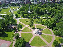
 An Aerial view of Boston Common
Firework displays over Boston Common began as early as July 3, 1745 in celebration of the fall of Louisburg, followed by the celebration of the repeal of the Stamp Act on May 19, 1766 and the first anniversary of the signing of the Declaration of Independence on July 4, 1777. True park status seems to have emerged no later than 1830, when the grazing of cows was ended and renaming the Common as Washington Park was proposed. Renaming the bordering Sentry Street to Park Place (later called Park Street) in 1804
[21]
already acknowledged the reality. By 1836, an ornamental iron fence fully enclosed the Common and its five perimeter malls or recreational promenade. Tremont Mall was an imitation of
St. James's Park
in London and had been in place since 1728.
The park was originally "out of bounds" for Blacks and Indians, a restriction that was fought by the Black community in Boston until it was lifted on July 4, 1836.
[22]
Boston Street Scene (Boston Common), Edward Mitchell Bannister, a depiction of the street and Boston Common area in 1898?99
Execution of Ann Hibbins on Boston Common, on charges of witchcraft, June 19, 1656. Sketch by F.T. Merril, 1886
The Common was used for a variety of purposes until its formal conversion into a public park during the 1830s. These uses gradually became more urban as the city developed, shifting from pastureland to military drilling field, execution grounds, public gathering place, and finally parkland.
The
Charles Street
side of Boston Common and the adjacent portions of the
Public Garden
were initially used as an unofficial dumping ground due to being in the lowest-lying portions of the two parks. This resulted in the portions of the two parks being "a moist stew that reeked and that was a mess to walk over" and driving visitors away from these areas, but the cost of repair prevented the work from being undertaken. This finally changed in the summer of 1895, when the required quantity of soil was made available as a result of the excavation of the
Tremont Street subway
which was used to regrade the Charles Street sides of Boston Common and the Public Garden.
[23]
A hundred people gathered on the Common in early 1965 to protest the
Vietnam War
. A second protest happened on October 15, 1969, this time with 100,000 people protesting in the
Moratorium to End the War in Vietnam
.
[24]
[25]
The Common was declared a National Historic Landmark in 1987.
[1]
[3]
It is managed by the Boston Park Department and cared for by
Friends of the Public Garden
, a private advocacy group which also provides additional funding for maintenance and special events.
[26]
Notable features
[
edit
]
 Boston Common in the fall of 2016
The Boston Common Frog Pond sits at the heart of the Common and is managed by the
Skating Club of Boston
in partnership with the City of Boston.
[27]
Frog Pond is home to a winter ice skating rink and learn-to-skate school, a reflecting pool in the spring and fall, and a summer spray pool and children's carousel.
The softball fields lie in the southwest corner of the Common. A grassy area forms the western part of the park and is most commonly used for the park's largest events. A parking garage lies under this part of the Common. A
granite slab there
commemorates
Pope John Paul II
's October 1, 1979 visit to Boston. The Pope said
mass
that day to an estimated 400,000 people.
[28]
In 1913 and 1986, prehistoric sites were discovered on the Common indicating American Indian presence long before it was colonized.
[29]
Since 1971, the Province of
Nova Scotia
has donated the
annual Christmas Tree
to the City of Boston as an enduring thank-you for the relief efforts of the Boston
Red Cross
and the Massachusetts Public Safety Committee following the
Halifax Explosion
of 1917.
[30]
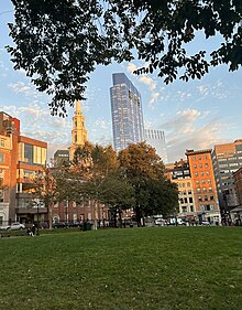 View of Boston Common and Park Street church at sunset
Structures
[
edit
]
- The
Boston Common Tablet
is installed near the corner of Park Street and Tremont Street.
- Declaration of Independence Tablet
- Plaque to the
Great Elm tree
which had been adorned with lanterns to represent liberty, used as a point of fortification, and used for hangings.
[31]
It was destroyed in a storm in 1876.
- The
Robert Gould Shaw Memorial
to
Robert Gould Shaw
and the Black
54th Massachusetts Volunteer Infantry
stands at Beacon and Park Streets, the northeast corner of the Common, opposite the State House.
- The
Soldiers and Sailors Monument
is a victory column on Flag Staff Hill in the Common, commemorating
Civil War
dead.
- The
Boston Massacre Monument
was dedicated November 14, 1888.
- The
Oneida Football Club Monument
memorializes the Common as the site of the first organized football games in the United States, played by the
Oneida Football Club
in 1862.
[32]
- Brewer Fountain
stands near the corner of Park and Tremont Streets by
Park Street Station
.
- Boylston
and Park Street stations were the first two subway stations in the United States; they lie underneath the southern and eastern corners of the park, respectively. Both stations have been in near-continuous operation since the opening of the first portion of the
Tremont Street subway
(now part of the
MBTA
's
Green Line
) on September 1, 1897.
- Parkman Bandstand
is in the eastern part of the park, used in musical and theatrical productions.
- Parkman Plaza
features the statues
Industry
,
Learning
, and
Religion
.
Neighboring structures
[
edit
]
 Massachusetts State House
overlooks part of the Common
Massachusetts State House
overlooks part of the Common
- The
Massachusetts State House
stands across Beacon Street from the northern edge of the Common.
- The
Boston Public Garden
, a more formal landscaped park, lies to the west of the Common across Charles Street (and was originally considered an extension of the Common).
- The
Masonic
Grand Lodge of Massachusetts
headquarters sits across from the southern corner of the Common at the intersection of Boylston and Tremont Streets.
- Across from the southern corner of the Common, along Boylston and Tremont Streets, lies the campus of
Emerson College
.
- Across from the Common, to the southeast,
Suffolk University
has a
dormitory
on Tremont Street.
Notable recurring events
[
edit
]
See also
[
edit
]
References
[
edit
]
- ^
a
b
James H. Charleton (November 1985).
"National Register of Historic Places Inventory-Nomination: Boston Common"
(PDF)
. National Park Service
. Retrieved
June 22,
2009
.
and
Accompanying photos: one aerial from 1972 and three from 1985
(1.43 MB)
- ^
"National Register Information System"
.
National Register of Historic Places
.
National Park Service
. January 23, 2007.
- ^
a
b
"Boston Common"
.
National Historic Landmark summary listing
. National Park Service. Archived from
the original
on February 3, 2015
. Retrieved
April 16,
2008
.
- ^
"Boston Common"
. CelebrateBoston.com. 2006
. Retrieved
March 26,
2011
.
- ^
City of Boston.
"Boston Common Study Report, Boston Landmarks Commission"
(PDF)
.
- ^
"Boston Common"
. City of Boston
. Retrieved
November 9,
2011
.
- ^
"Place Names: Boston English"
. Adam Gaffin and by content posters
. Retrieved
November 9,
2011
.
- ^
a
b
Friends of the Public Garden and Common; Moore, Barbara W.; Weesner, Gail; Lee, Henry; McIntyre, A. McVoy; Webster, Larry.
"History of Boston Common"
(PDF)
.
City of Boston
. Retrieved
October 19,
2022
.
- ^
a
b
"Boston Common | The Freedom Trail"
.
www.thefreedomtrail.org
. Retrieved
October 19,
2022
.
- ^
Loewen, James
(1999).
Lies Across America: What Our Historic Sites Get Wrong
. New York:
The New Press
. p.
414
.
ISBN
0-9650031-7-5
.
- ^
Lowen, James (1994) Planning the City Upon a Hill: Boston Since 1630University of Massachusetts Press (Boston)
ISBN
0-87023-923-6
,
ISBN
978-0-87023-923-6
, p. 53
- ^
Boston Common & Public Gardens - Great Public Spaces | Project for Public Spaces
Archived
November 8, 2011, at the
Wayback Machine
. PPS. Retrieved on August 21, 2013.
- ^
Vale, Lawrence J. (2000).
From the Puritans to the Projects: Public Housing and Public Neighbors
.
Cambridge, MA
:
Harvard University Press
. p. 13.
ISBN
978-0674025752
.
- ^
Vale, Lawrence J. (2000).
From the Puritans to the Projects: Public Housing and Public Neighbors
.
Cambridge, MA
:
Harvard University Press
. p. 28.
ISBN
978-0674025752
.
- ^
Shurtleff, Nathaniel Bradstreetl (1871).
A Topographical and Historical Description of Boston
. Boston: Boston City Council. pp.
211
.
- ^
Rogers, Horatio, 2009.
Mary Dyer of Rhode Island: The Quaker Martyr That Was Hanged on Boston
pp.1?2. BiblioBazaar, LLC
- ^
J. Besse,
A Collection of the Sufferings of the People called Quakers
, 1753, Vol. 2, pp. 203-05.
- ^
ODNB
article by John C. Shields, 'Leddra, William (d. 1661)', Oxford Dictionary of National Biography, Oxford University Press, Sept 2004; online edn, May 2007
[1]
, accessed August 16, 2009
- ^
Zinn, Howard
.
A People's History of the United States
. New York: Perennial, 2003. p.51
ISBN
0-06-052837-0
- ^
Gaskell, Philip; Franklin, Benjamin; LeMay, J. A. Leo; Zall, P. M. (October 1984).
"The Autobiography of Benjamin Franklin: A Genetic Text"
.
The Modern Language Review
.
79
(4): 908.
doi
:
10.2307/3730147
.
ISSN
0026-7937
.
JSTOR
3730147
.
- ^
"A Brief History of the Union Club"
. The Union Club of Boston. Archived from
the original
on April 1, 2012
. Retrieved
October 4,
2012
.
- ^
Hayden, Robert C. (1991).
African-Americans in Boston: More than 350 Years
(2nd ed.). Boston, Massachusetts: Trustees of the Public Library of the City of Boston. p. 34.
ISBN
0-89073-083-0
.
- ^
Most, Doug (2014).
The Race Underground: Boston, New York, and the Incredible Rivalry that Built America's First Subway
. St. Martin's Press. pp.
233?234
.
ISBN
978-1-250-06135-5
.
- ^
Zinn, Howard. p.486
- ^
Hastings, Max (2018).
Vietnam: An Epic Tragedy, 1945-1975
(1 ed.). New York, NY.
ISBN
978-0-06-240566-1
.
OCLC
1001744417
.
{{
cite book
}}
: CS1 maint: location missing publisher (
link
)
- ^
"Friends of the Public Garden"
.
- ^
"The Boston Common Frog Pond | The Skating Club of Boston"
.
scboston.org
. Retrieved
November 3,
2017
.
- ^
"Boston marks 35 years since Pope St. John Paul II's visit"
.
www.thebostonpilot.com
.
- ^
Research at Boston University
. Bu.edu (January 10, 2007). Retrieved on 2013-08-21.
- ^
"Boston Common tree arrives; Mayor will virtually light tree on December 3"
.
Boston.gov
. November 19, 2020.
- ^
"Boston Common Great Elm"
.
celebrateboston.com
.
- ^
Winthrop Saltonstall Scudder,
An historical sketch of the Oneida football club of Boston, 1862-1865
(Boston, 1926)
Further reading
[
edit
]
- The public rights in Boston Common: Being the report of a committee of citizens. Boston: Press of Rockwell and Churchill, 1877
Google books
- Samuel Barber. Boston Common: a diary of notable events, incidents, and neighboring occurrences, 2nd ed. Boston: Christopher Publishing House, 1916.
Internet Archive
External links
[
edit
]
42°21′18″N
71°03′56″W
/
42.35500°N 71.06556°W
/
42.35500; -71.06556
| Preceded by
First location ? beginning of trail
|
Locations along Boston's
Freedom Trail
Boston Common
|
Succeeded by
|
|
|---|
| Topics
| | |
|---|
| Lists by county
| |
|---|
| Lists by city
| | Barnstable County
| |
|---|
| Bristol County
| |
|---|
| Essex County
| |
|---|
| Hampden County
| |
|---|
| Middlesex County
| |
|---|
| Norfolk County
| |
|---|
| Suffolk County
| |
|---|
| Worcester County
| |
|---|
|
|---|
| Other lists
| |
|---|
|
|
|---|
| International
| |
|---|
| National
| |
|---|
| Geographic
| |
|---|
| Other
| |
|---|