Ancient settlement and town in Israel
"Beisan" redirects here. For the Ancient Egyptian steles discovered in this locality, see
Beisan steles
.
Town in Israel
 Archaeological excavation at Tell Beth Shean in 1937. The town is seen at the top half of the picture
Beit She'an
(
Hebrew
:
????? ??????
B?? ????n
ⓘ
), also
Beth-shean
, formerly
Beisan
(
Arabic
:
?????
Bis?n
ⓘ
),
[2]
is a town in the
Northern District
of
Israel
. The town lies at the
Beit She'an Valley
about 120 m (394 feet) below sea level.
Beit She'an is believed to be one of the oldest cities in the region. It has played an important role in history due to its geographical location at the junction of the
Jordan River Valley
and the
Jezreel Valley
. Beth She'an's ancient
tell
contains remains beginning in the
Chalcolithic period
. When
Canaan
came under
Imperial Egyptian rule
in the
Late Bronze Age
, Beth She'an served as a major Egyptian administrative center.
[3]
The city came under
Israelite
rule in the monarchic period. It probably fell under
Philistine
control during the time of
Saul
, when, according to the
Bible
, his body was displayed there along with his sons'.
[4]
During the
Hellenistic period
, the settlement was known as
Scythopolis
(
Ancient Greek
:
Σκυθ?πολι?
). After the region came under
Roman
rule, Scythopolis gained imperial free status and was the leading city of the
Decapolis
. A multi-cultural metropolis under
Byzantine
rule, it served as the capital of the province of
Palaestina Secunda
, and had a mixed population of
Christians
,
pagans
,
Jews
and
Samaritans
. After the
Arab conquest of the Levant
, and following a series of devastating earthquakes (most notably in
749
), the city lost its prominence, and became a medium-sized country town.
[3]
[5]
The population of the town was completely changed from 1948 to 1950. It had been entirely
Muslim
and Christian, designated to be part of the Jewish state in the 1947
United Nations Partition Plan for Palestine
, and was captured by the
Haganah
in May 1948. The battle over the town during
Operation Gideon
caused most of its inhabitants to flee, and the remainder were expelled.
[6]
The town was then resettled by Jewish immigrants.
[6]
Today, Beit She'an serves as a regional centre for the towns in the Beit She'an Valley. The ancient city ruins are now protected within the
Beit She'an National Park
. The town is located near the
Jordan River Crossing
, one of three crossing points between Israel and
Jordan
.
Geography
[
edit
]
 Ancient ruins of Beit She'an
Beit She'an's location has always been strategically significant, due to its position at the junction of the Jordan River Valley and the
Jezreel Valley
, essentially controlling access from
Jordan
and the inland to the coast, as well as from
Jerusalem
and
Jericho
to the
Galilee
.
Beit She'an is situated on
Highway 90
, the north?south road which runs the length of the eastern edge of Israel and the West Bank. The city stretches over an area of 7 square kilometers with a substantial national park in the north of the city. Beit She'an has a population of 20,000.
[7]
Today the town is under the administration of the
Emek HaMa'ayanot Regional Council
.
History
[
edit
]
Prehistory (Neolithic and Chalcolithic periods)
[
edit
]
In 1933, archaeologist G.M. FitzGerald, under the auspices of the
University of Pennsylvania Museum
, carried out a "deep cut" on Tell el-Hisn ("castle hill"), the large
tell
, or mound, of Beth She'an, in order to determine the earliest occupation of the site. His results suggest that settlement began in the
Late Neolithic
or
Early Chalcolithic
periods (sixth to fifth millennia BC.)
[8]
Occupation continued intermittently throughout the Late Neolithic and Chalcolithic periods, with a likely gap during the Late Chalcolithic period (ca. 4000?3300 BC).
[9]
Early Bronze Age
[
edit
]
 House of the Egyptian governor on Tell el-Husn
Settlement seems to have resumed at the beginning of the
Early Bronze Age
I (3200?3000) and continues throughout this period, is then missing during the Early Bronze Age II, and then resumes in the Early Bronze Age III.
[9]
Middle Bronze Age
[
edit
]
A large cemetery on the northern mound was in use from the Bronze Age to
Byzantine
times.
[10]
Canaanite
graves dating from 2000 to 1600 BC were discovered there in 1926.
[11]
Late Bronze Age
[
edit
]
Egyptian period
[
edit
]
After the
conquest of Beit She'an by Pharaoh Thutmose III
in the 15th century BCE, as recorded in an inscription at
Karnak
,
[12]
the small town on the summit of the mound became the center of the Egyptian administration of the region.
[13]
The Egyptian newcomers changed the organization of the town and left a great deal of material culture behind. A large Canaanite temple (39 m (128 ft) in length) excavated by the
University of Pennsylvania Museum
(Penn Museum) may date from about the same period as
Thutmose III
's conquest, though the Hebrew University excavations suggest that it dates to a later period.
[14]
Artifacts of potential cultic significance were found around the temple. Based on
an Egyptian stele
found at the place, the temple was dedicated to the god Mekal.
[15]
The
Hebrew University
excavations determined that this temple was built on the site of an earlier one.
[16]
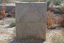 Lion and Lioness, 14th century BC
One of the most important finds near the temple is the Lion and Lioness (or a dog
[17]
) stela, currently in the
Israel Museum
in Jerusalem, which depicts the two playing.
[18]
During the three hundred years of rule by the
New Kingdom of Egypt
, the population of Beit She'an appears to have been primarily Egyptian administrative officials and military personnel. The town was completely rebuilt, following a new layout, during the
19th dynasty
.
[19]
The Penn Museum excavations uncovered
two important stelae
from the period of
Seti I
and a monument of
Ramesses II
.
[20]
One of those steles is particularly interesting because, according to
William F. Albright
,
[21]
it testifies to the presence of a Hebrew population: the
Habiru
, which Seti I protected from an Asiatic tribe. Pottery was produced locally, but some was made to mimic Egyptian forms.
[22]
Other Canaanite goods existed alongside Egyptian imports, or locally made Egyptian-style objects.
[23]
The
20th Dynasty
saw the construction of large administrative buildings in Beit She'an, including "Building 1500", a small palace for the Egyptian governor.
[24]
During the 20th Dynasty, invasions of the "
Sea Peoples
" upset Egypt's control over the
Eastern Mediterranean
. Though the exact circumstances are unclear, the entire site of Beit She'an was destroyed by fire around 1150 BC. The Egyptians did not attempt to rebuild their administrative center and finally lost control of the region.
Over 50 clay anthropoid coffins were found at the site mainly from the 13th and 12th
centuries BC. Most are in the typical Egyptian style but some are of a "grotesque" type linked to the Aegean which caused earlier archaeologists to suggest they were of the "sea peoples" which pharaoh Ramses III claimed to have resettled in the region.
[25]
Iron Age
[
edit
]
 Terracotta sarcophagus Beth Shean northern cemetery tomb 202A Iron IA 1200?1150 BCE Penn Museum 02
An
Iron Age
I (1200?1000 BC) Canaanite city was constructed on the site of the Egyptian center shortly after its destruction.
[26]
According to the
Hebrew Bible
, around 1000 BC the town became part of the
larger Israelite kingdom
.
1 Kings
(
1 Kings 4:12
) refers to Beit She'an as part of the kingdom of
Solomon
, though the historical accuracy of this list is debated.
[27]
Nevertheless, recent archaeomagnetic dates suggest that the first Israelite urban settlement was established either during the Solomonic period or in the pre-Omride phase of the early
kingdom of Israel
at the latest, and that it was probably destroyed around 935?900 BC.
[28]
The
Assyrian
conquest of the
northern kingdom of Israel
under
Tiglath-Pileser III
(732 BC) brought about the destruction of Beit She'an by fire.
[22]
Minimal reoccupation occurred until the
Hellenistic period
.
[22]
Biblical narrative
[
edit
]
The
Hebrew Bible
identifies Beit She'an as where the bodies of
King Saul
and three of his sons were hung by the
Philistines
after the
Battle of Gilboa
.
[29]
[30]
[31]
According to the biblical narrative, the battle was fought at
Mount Gilboa
, around the year 1010 BC. The Philistines prevailed and Saul died in battle together with three of his sons,
Jonathan
,
Abinadab
and
Malchishua
, (
1 Samuel
and
1 Chronicles
,
1 Samuel 31; 1 Chronicles 10
).
1 Samuel 31:10
states that "the victorious Philistines hung the body of King Saul on the walls of Beit She'an". Later, the people of
Jabesh-Gilead
took the remnants, carried them into their city, and burned them. No archeological evidence was found of a Philistine occupation of Beit She'an, but it is possible the force only passed there.
[17]
Hellenistic period
[
edit
]
 Map of the
Decapolis
showing the location of Beit She'an, here called by its Greek name, Scythopolis
Map of the
Decapolis
showing the location of Beit She'an, here called by its Greek name, Scythopolis
The
Hellenistic period
saw the reoccupation of the site of Beit She'an under the new name "Scythopolis" (
Ancient Greek
: Σκυθ?πολι?),
[32]
meaning "City of the Scythians", possibly named after the
Scythian
mercenaries who settled there as veterans.
[33]
Little is known about the Hellenistic city, but during the 3rd century BCE a large temple was constructed on the tell.
[34]
It is unknown which deity was worshipped there, but the temple continued to be used during Roman times. Graves dating from the Hellenistic period are simple, singular
rock-cut tombs
.
[35]
From 301 to 198 BCE the area was under the control of the
Ptolemies
, and Beit She'an is mentioned in 3rd?2nd century BCE written sources describing the
Syrian Wars
between the Ptolemaic and
Seleucid
dynasties. In 198 BCE the Seleucids finally conquered the region.
Roman period
[
edit
]
In 63 BCE,
Pompey
made
Judea
a part of the
Roman Republic
. Beit She'an was refounded and rebuilt by
Gabinius
.
[36]
The town center shifted from the summit of the mound, or tell, to its slopes. Scythopolis prospered and became the leading city of the
Decapolis
, the only one west of the Jordan River.
[37]
The city flourished under the "
Pax Romana
", as evidenced by high-level
urban planning
and extensive construction, including the best preserved Roman theatre of ancient
Samaria
, as well as a
hippodrome
, a
cardo
and other trademarks of the Roman influence.
Mount Gilboa
, 7 km (4 mi) away, provided dark
basalt
blocks, as well as water (via an aqueduct) to the town. Beit She'an is said to have sided with the Romans during the early phase of the
First Jewish?Roman War
in 66 CE.
[36]
Excavations have focused less on the Roman period ruins, so not much is known about this period.
[
dubious
–
discuss
]
The Penn. University Museum excavation of the northern cemetery, however, did uncover significant finds. The Roman period tombs are of the
loculus
type: a rectangular rock-cut spacious chamber with smaller chambers (
loculi
) cut into its side.
[35]
Bodies were placed directly in the
loculi
, or inside sarcophagi which were placed in the
loculi
. A
sarcophagus
with an inscription identifying its occupant in Greek as "Antiochus, the son of Phallion", may have held the cousin of
Herod the Great
.
[35]
One of the most interesting Roman grave finds was a
bronze incense shovel
with the handle in the form of an animal leg, or hoof, now in the
University of Pennsylvania Museum
.
[38]
-
The Roman theatre
-
Roman cardo
-
Roman baths
Byzantine period
[
edit
]
 Mosaic from 5th?7th century synagogue in northern Beit Shean, possibly Samaritan (Israel Museum)
[39]
Mosaic from 5th?7th century synagogue in northern Beit Shean, possibly Samaritan (Israel Museum)
[39]
Copious archaeological remains were found dating to the
Byzantine
period (330?636 CE) and were excavated by the
University of Pennsylvania Museum
from 1921 to 1923. A rotunda church was constructed on top of the Tell and the entire city was enclosed in a wall.
[40]
Textual sources mention several other churches in the town.
[40]
Beit She'an was primarily Christian, as attested to by the large number of churches, but evidence of Jewish habitation and a Samaritan synagogue indicate established communities of these minorities. The pagan temple in the city centre was destroyed, but the
nymphaeum
and
Roman baths
were restored. Many of the buildings of Scythopolis were damaged in the
Galilee earthquake of 363
, and in 409 it became the capital of the northern district,
Palaestina Secunda
.
[41]
As such,
Scythopolis
(v.) also became the Metropolitan
archdiocese
of the province.
Dedicatory inscriptions indicate a preference for donations to religious buildings, and many colourful
mosaics
, such as that featuring the
zodiac
in the Monastery of Lady Mary, or the one picturing a
menorah
and shalom in the House of Leontius' Jewish synagogue, were preserved. A Samaritan synagogue's mosaic was unique in abstaining from human or animal images, instead utilising floral and geometrical motifs. Elaborate decorations were also found in the settlement's many luxurious villas, and in the 6th century especially, the city reached its maximum size of 40,000 and spread beyond its period city walls.
[41]
The Byzantine period portion of the northern cemetery was excavated in 1926. The tombs from this period consisted of small rock-cut halls with vaulted graves on three sides.
[42]
A great variety of objects were found in the tombs, including
terracotta
figurines possibly depicting the
Virgin and Child
, many terracotta lamps, glass mirrors, bells, tools, knives, finger rings, iron keys, glass beads, bone hairpins, and many other items.
[42]
Important Christian personalities who lived or passed through Byzantine Scythopolis are St
Procopius of Scythopolis
(died July 7, 303 AD),
Cyril of Scythopolis
(ca. 525?559), St
Epiphanius of Salamis
(c. 310/320 ? 403) and
Joseph of Tiberias
(c. 285 ? c. 356) who met there around the year 355.
Early Muslim period
[
edit
]
In 634, Byzantine forces were defeated by the
Muslim army
of
Caliph Umar ibn al-Khattab
and the city reverted to its Semitic name, being named Baysan in Arabic. The day of victory came to be known in Arabic as
Yawm Baysan
or "the day of Baysan."
[2]
The city was not damaged and the newly arrived Muslims lived together with its Christian population until the 8th century, but the city declined during this period. Structures were built in the streets themselves, narrowing them to mere
alleyways
, and makeshift shops were opened among the colonnades. The city reached a low point by the 8th century, witnessed by the removal of
marble
for producing
lime
, the blocking off of the main street, and the conversion of a main plaza into a cemetery.
[43]
However, some recently discovered counter-evidence may be offered to this picture of decline. In common with state-directed building work carried out in other towns and cities in the region during the 720s,
[44]
Baysan's commercial infrastructure was refurbished: its main colonnaded market street, once thought to date to the sixth century, is now known?on the basis of a mosaic inscription?to be a redesign dating from the time of the Umayyad caliph
Hisham
(r. 724?43).
[45]
Abu Ubayd al-Andalusi noted that the wine produced there was delicious.
[2]
On January 18, 749, Umayyad Baysan was completely devastated by a
catastrophic earthquake
. A few residential neighborhoods grew up on the ruins, probably established by the survivors, but the city never recovered its magnificence. The city center moved to the southern hill where later the Crusaders built their castle.
[46]
Jerusalemite historian
al-Muqaddasi
visited Baysan in 985, during
Abbasid
rule and wrote that it was "on the river, with plentiful palm trees, and water, though somewhat heavy (brackish.)" He further noted that Baysan was notable for its
indigo
, rice,
dates
and grape syrup known as
dibs
.
[47]
The town formed one of the districts (
kurah
) of
Jund al-Urdunn
during this period.
[48]
Its principal
mosque
was situated in the center of its marketplace.
[49]
Crusader period
[
edit
]
 Crusader castle with moat and inner tower.
In the
Crusader
period, the Lordship of Bessan was occupied by
Tancred, Prince of Galilee
in 1099; it was never part of the
Principality of Galilee
, despite its location, but became a royal domain of the
Latin Kingdom of Jerusalem
in 1101, probably until around 1120. According to the
Lignages d'Outremer
, the first Crusader lord of Bessan once it became part of the Kingdom of Jerusalem was Adam, a younger son of Robert III de Bethune, peer of
Flanders
and head of the
House of Bethune
. His descendants were known by the family name
de Bessan
.
It occasionally passed back under royal control until new lords were created. The town became part of the
Belvoir
fiefdom
.
[50]
A small Crusader fortress surrounded by a moat was built in the area southeast of the Roman theatre, where the diminished town had relocated after the 749 earthquake.
[46]
The fortress was destroyed by
Saladin
in 1183.
[51]
During the 1260
Battle of Ain Jalut
, retreating Mongol forces passed in the vicinity but did not enter the town itself.
Mamluk period
[
edit
]
 Plan of Beisan-Scythopolis from the 1871?1877
PEF Survey of Palestine
Plan of Beisan-Scythopolis from the 1871?1877
PEF Survey of Palestine
Under
Mamluk
rule, Beit She'an was the principal town in the district of
Damascus
and a relay station for the
postal service
between
Damascus
and
Cairo
. It was also the capital of
sugar cane
processing for the region. Jisr al-Maqtu'a, "the truncated/cut-off bridge", a bridge consisting of a single arch spanning 25 ft (7.6 m) and hung 50 ft (15 m) above a stream, was built during that period.
[52]
Ottoman period
[
edit
]
 Ottoman Saraya
During this period the inhabitants of Beit She'an were mainly Muslim. There were however some Jews. For example, the 14th century
topographer
Ishtori Haparchi
settled there and completed his work
Kaftor Vaferach
in 1322, the first Hebrew book on the geography of the Land of Israel.
[53]
[54]
During the 400 years of
Ottoman
rule, Baysan lost its regional importance. During the reign of Sultan
Abdul Hamid II
when the
Jezreel Valley railway
, which was part of the
Haifa
-Damascus extension of the
Hejaz railway
was constructed, a limited revival took place. The local peasant population was largely impoverished by the Ottoman feudal land system which leased tracts of land to tenants and collected taxes from them for their use.
[2]
The Swiss?German traveler
Johann Ludwig Burckhardt
described Beisan in 1812: "The present village of Bysan contains seventy or eighty houses; its inhabitants are in a miserable condition, from being exposed to the depredations of the
Bedouins
of the Ghor, to whom they also pay a heavy tribute."
[55]
In 1870/1871 (1288
AH
), an Ottoman census listed the village in the
nahiya
(sub-district) of Shafa al-Shamali.
[56]
In the early 20th century, though still a small and obscure village, Beisan was known for its plentiful water supply, fertile soil, and its production of olives, grapes, figs, almonds, apricots, and apples.
[2]
British Mandate period
[
edit
]
Under the Mandate, the city was the center of the
District of Baysan
. According to a
census
conducted in 1922 by the
British Mandate authorities
, Beit She'an (Baisan) had a population of 1,941, consisting of 1,687 Muslims, 41 Jews and 213 Christians.
[57]
In 1934,
Lawrence of Arabia
noted that "Bisan is now a purely Arab village," where "very fine views of the river can be had from the housetops." He further noted that "many nomad and
Bedouin
encampments, distinguished by their black tents, were scattered about the riverine plain, their flocks and herds grazing round them."
[2]
Beisan was home to a mainly
Mizrahi Jewish
community of 95 until 1936, when the
1936?1939 Arab revolt
saw Beisan serve as a center of Arab attacks on Jews in Palestine.
[54]
[58]
[59]
In 1938, after learning of the murder of his close friend and Jewish leader Haim Sturmann,
Orde Wingate
led his men on an offensive in the Arab section of Baysan, the rebels’ suspected base.
[60]
According to population surveys conducted in
British Mandate Palestine
, Beisan consisted of 5,080 Muslim Arabs out of a population of 5,540 (92% of the population), with the remainder being listed as Christians.
[61]
In 1945, the surrounding
District of Baysan
consisted of 16,660 Muslims (67%), 7,590 Jews (30%), and 680 Christians (3%); and Arabs owned 44% of land, Jews owned 34%, and 22% constituted public lands. The
1947 UN Partition Plan
allocated Beisan and most of its district to the proposed
Jewish state
.
[2]
[62]
[63]
Jewish forces and local Bedouins first clashed during the
1947?1948 civil war in Mandatory Palestine
in February and March 1948, part of
Operation Gideon
,
[2]
which
Walid Khalidi
argues was part of a wider
Plan Dalet
.
[64]
Joseph Weitz
, a leading
Yishuv
figure, wrote in his diary on May 4, 1948, that, "The Beit Shean Valley is the gate for our state in the Galilee...[I]ts clearing is the need of the hour."
[2]
Beisan, then an Arab village, fell to the Jewish militias three days before the end of the Mandate.
State of Israel
[
edit
]
 War monument,
Al Mansfeld
, 1960
War monument,
Al Mansfeld
, 1960
After
Israel's Declaration of Independence
in May 1948, during intense shelling by Syrian border units, followed by the recapture of the valley by the
Haganah
, the Arab inhabitants
fled
across the Jordan River.
[65]
The property and buildings abandoned after the conflict were then held by the State of Israel.
[2]
Most
Arab Christians
relocated to
Nazareth
. A
ma'abarah
(refugee camp) inhabited mainly by North African Jewish refugees
[66]
was erected in Beit She'an, and it later became a
development town
.
From 1969, Beit She'an was a target for
Katyusha rockets
and
mortar
attacks from Jordan.
[67]
In the
1974 Beit She'an attack
, militants of the
Popular Democratic Front for the Liberation of Palestine
, took over an apartment building and murdered a family of four.
[58]
In 1999, Beit She'an was incorporated as a city.
[68]
Geographically, it lies in the middle of the
Emek HaMaayanot Regional Council
, formerly the Beit She'an Valley Regional Council.
[69]
Beit She'an was the hometown and political power base of
David Levy
, an Israeli politician.
During the
Second Intifada
, in the
2002 Beit She'an attack
, six Israelis were killed and over 30 were injured by two
Palestinian militants
, who opened fire and threw grenades at a polling station in the center of Bet She'an where party members were voting in the
Likud
primary.
Archaeology and tourism
[
edit
]
 Rehov inscription
The
University of Pennsylvania
carried out excavations of ancient Beit She'an in 1921?1933. Relics from the
Egyptian period
were discovered, most of them now exhibited in the
Rockefeller Museum
in
Jerusalem
. Some are in the
University of Pennsylvania Museum
in
Philadelphia
.
[70]
Excavations at the site were resumed by the
Hebrew University of Jerusalem
in 1983 and then again from 1989 to 1996 under the direction of
Amihai Mazar
.
[71]
The excavations have revealed no less than 18 successive ancient towns.
[72]
[73]
Ancient Beit She'an, one of the most spectacular Roman and Byzantine sites in Israel, is a major tourist attraction.
[74]
The seventh century
Mosaic of Rehob
was discovered by farmers of
Kibbutz
Ein HaNetziv
. Part of a mosaic floor, it contains details of Jewish religious laws concerning tithes and the Sabbatical Year.
[75]
Earthquakes
[
edit
]
Beit She'an is located above the
Dead Sea Transform
(a
fault
system that forms the
transform boundary
between the
African Plate
to the west and the
Arabian Plate
to the east) and is one of the cities in Israel most at risk to
earthquakes
(along with
Safed
,
Tiberias
,
Kiryat Shmona
and
Eilat
).
[76]
Historically, the city was destroyed in the
Golan earthquake of 749
.
Demographics
[
edit
]
According to the
Israel Central Bureau of Statistics
(CBS), the population of the municipality was 19,073 at the end of 2022.
[1]
In 2005, the ethnic makeup of the city was 99.5% Jewish and other non-Arab (97.3% Jewish), with no significant Arab population. See
Population groups in Israel
. The population breakdown by gender was 8,200 males and 8,100 females.
[77]
The age distribution was as follows:
Economy
[
edit
]
 Beit She'an municipality
 Beit She'an park
Beit She'an is a center of cotton-growing, and many of residents are employed in the cotton fields of the surrounding
kibbutzim
. Other local industries include a textile mill and clothing factory.
[54]
When the ancient city of Beit She'an was opened to the public in the 1990s and turned into a national park, tourism became a major sector of the economy.
[78]
Transportation
[
edit
]
 New railway station, Beit She'an
Beit She'an had a railway station that opened in 1904 on the
Jezreel Valley railway
which was an extension of the
Hejaz railway
. This station closed together with the rest of the Jezreel Valley railway in 1948. In 2011?2016 the valley railway was rebuilt and the new
Beit She'an railway station
, located at the same site as the historical station was opened. Passenger service offered at the station connects the city to Afula, Haifa and destinations in between. In addition to passenger service, the station also includes a freight rail terminal.
Sports
[
edit
]
The local football club,
Hapoel Beit She'an
spent several seasons in the top division in the 1990s, but folded in 2006 after several relegations. Maccabi Beit She'an currently plays in
Liga Bet
.
[
citation needed
]
Notable people
[
edit
]
Twin towns ? sister cities
[
edit
]
Beit She'an is
twinned
with:
Historic images
[
edit
]
-
Historic railway station, 1930s
-
Beit She'an after conquest, 1948
-
Ottoman Saray building used by
Yiftach Brigade
as company barracks, 1948
-
Beit Shean ruins
-
Lions playing sculpture, roundabout in Beit Shean
See also
[
edit
]
References
[
edit
]
- ^
a
b
"Regional Statistics"
. Israel Central Bureau of Statistics
. Retrieved
21 March
2024
.
- ^
a
b
c
d
e
f
g
h
i
j
k
Shahin, Mariam (2005).
Palestine: A Guide
. Interlink Books. pp.
159?165
.
ISBN
978-1-56656-557-8
.
- ^
a
b
c
"Bet She?an | Israel | Britannica"
.
www.britannica.com
. Retrieved
2022-06-29
.
- ^
Lemche, Niels Peter (2004).
Historical dictionary of ancient Israel
. Historical dictionaries of ancient civilizations and historical eras. Lanham, Md.: Scarecrow Press. pp. 84?85.
ISBN
978-0-8108-4848-1
.
- ^
????, ????? (2014). "??????? ??????: ?????? ????? ???? ??? ????? ?????? ???????? ??????" [Intensification and abatement: processes of change in the cities of Palestine during the early Muslim period].
?????
(in Hebrew) (153): 42?43.
- ^
a
b
Arnon Golan (2002) Jewish Settlement of Former Arab Towns and Their Incorporation into the Israeli Urban System (1948-50), Israel Affairs, 9:1-2, 149-164, DOI: 10.1080/714003467 "The former Arab town of Beisan... Jewish troops took over the town and its environs in fighting in April and May 1948. Most of the Arab population fled at that time, while the handful of remaining residents were expelled following the town's surrender on 13 May, after which it was placed under military government. As early as June 1948 the Israeli authorities initiated a new settlement venture in the Beit Shean valley, which established three new kibbutzim by March 1949. To block any possible return of former Arab residents, the local military government began the demolition of the town's built-up area; this was halted only by the intervention of the Israeli agriculture minister, Aaron Ziesling, who opposed the demolition policy on ideological grounds... The government decided to build 1,000 new apartments in Beisan and to restore 600 former Arab dwelling units for immigrants. In April 1950 the Jewish population of Beisan, renamed in Hebrew "Beit Shean", numbered 2,000, all of them newly arrived immigrants."
- ^
Nefesh B'Nefesh Profiles: Beit She'an
- ^
Braun, Eliot.
Early Beth Shean (Strata XIX-XIII): G.M. FitzGerald's Deep Cut on the Tell
, p. 28
- ^
a
b
Braun, p.61-64
- ^
Rowe, Alan.
The Topography and History of Beth Shean
. Philadelphia: 1930, p. v
- ^
Rowe, p. 2
- ^
No. 110: bt ?'ir. Mazar, Amihai. "Tel Beth-Shean: History and Archaeology." In
One God, One Cult, One Nation
. Ed. R.G. Kratz and H. Spieckermann. New York: 2010, P. 239
- ^
Mazar 242
- ^
Rowe, 10;
http://www.rehov.org/project/tel_beth_shean.htm
Archived
2012-02-06 at the
Wayback Machine
- ^
Rowe 11
- ^
Mazar 247
- ^
a
b
"Tel Beth Shean: An Account of the Hebrew University Excavations"
.
www.rehov.org
. Archived from
the original
on 2012-02-06.
- ^
Lion and Lioness playing
, Israel Museum
- ^
Mazar 250
- ^
Rowe 23?32
- ^
Albright W. The smaller Beth-Shean stele of Sethos I (1309-1290 B. C.), Bulletin of the American schools of Oriental research, feb 1952, p. 24-32.
- ^
a
b
c
"Tel Beth Shean: An Account of the Hebrew University's Excavations"
. Rehov.org. Archived from
the original
on 2012-02-06
. Retrieved
2012-03-04
.
- ^
Mazar 256
- ^
Mazar 253
- ^
Emanuel, Jeffrey P. “‘SEA PEOPLES’ IN EGYPTIAN GARRISONS IN LIGHT OF BETH-SHEAN, (RE-)RECONSIDERED.” Mediterranean Archaeology, vol. 28/29, 2015, pp. 1?22
- ^
"The Beth-Shean Valley Archaeological Project"
. Rehov.org. Archived from
the original
on 2012-02-04
. Retrieved
2012-03-04
.
- ^
Mazar 263
- ^
Vaknin, Yoav; Mazar, Amihai; Shaar, Ron; Ben-Yosef, Erez (2023).
"Tel Beth-Shean in the Tenth?Ninth Centuries BCE: A Chronological Query and Its Possible Archaeomagnetic Resolution"
. In Ben-Yosef, Erez; Jones, Ian W. N. (eds.).
"And in Length of Days Understanding" (Job 12:12): Essays on Archaeology in the Eastern Mediterranean and Beyond in Honor of Thomas E. Levy
. Springer Nature. pp. 787?810.
ISBN
978-3-031-27330-8
.
- ^
1 Samuel 31:10?12
- ^
"Was King Saul Impaled on the Wall of Beth Shean?"
.
The BAS Library
. August 31, 2015.
- ^
"Beit She'an, Archaeology in Israel"
.
www.jewishmag.co.il
.
- ^
Meyers & Chancey 13
- ^
Avi-Yonah, M. (1962).
"Scythopolis"
.
Israel Exploration Journal
.
12
(2). Israel Exploration Society: 123?134.
ISSN
0021-2059
.
JSTOR
27924894
. Retrieved
2023-04-15
.
- ^
Rowe 44
- ^
a
b
c
Rowe 49
- ^
a
b
Rowe 46
- ^
"Tel Aviv University Institute of Archaeology"
.
en-humanities.tau.ac.il
.
- ^
Rowe 53
- ^
Synagogue floor
: Beth Shean synagogue, ay IMJ website, accessed 16 July 2019
- ^
a
b
Rowe 50
- ^
a
b
Rowe 45
- ^
a
b
Rowe 52
- ^
"Beit She'an"
.
Jewish Virtual Library
.
- ^
A. Walmsley, "Economic Developments and the Nature of Settlement in the Towns and Countryside of Syria-Palestine, ca. 565?800", Dumbarton Oaks Papers 61 (2007), especially pp. 344?45.
- ^
E. Khamis, "Two wall mosaic inscriptions from the Umayyad market place in Bet Shean/Baysan",
Bulletin of the School of Oriental and African Studies
64 (2001), pp. 159?76.
- ^
a
b
"Israel Antiquities Authority, Death of a City"
. Antiquities.org.il. Archived from
the original
on 2013-09-15
. Retrieved
2012-12-30
.
- ^
le Strange, 1890, pp.
18
?19.
- ^
le Strange, 1890, p.
30
- ^
le Strange, 1890, p.
411
- ^
?? ????? ??? ???
(in Hebrew). Israel National Parks Authority. Archived from
the original
on 2012-04-25.
- ^
Avraham Negev and Shimon Gibson (2001). "Beth Shean (city); Scythopolis".
Archaeological Encyclopedia of the Holy Land
. New York and London: Continuum. p. 86.
ISBN
978-0-8264-1316-1
.
- ^
Shahin, 2005, p.
164
- ^
"????? ???? - ??????, ????? (page 1 of 363)"
.
hebrewbooks.org
. Retrieved
2024-04-29
.
- ^
a
b
c
"Bet She'an"
.
Encyclopædia Britannica
. Retrieved
2008-10-20
.
- ^
Burckhardt, John Lewis (1822).
Travels in Syria and the Holy Land
. J. Murray. p. 343.
ISBN
978-1-4142-8338-8
.
- ^
Grossman, David (2004).
Arab Demography and Early Jewish Settlement in Palestine
. Jerusalem: Magnes Press. p. 256.
- ^
Barron, 1923, p.
6
- ^
a
b
Ashkenazi, Eli (2007-05-11).
"The other Beit She'an"
.
Haaretz
. Retrieved
2008-10-20
.
- ^
"Virtual Israel Experience:Bet She'an"
.
Jewish Virtual Library
. Retrieved
2008-10-20
.
- ^
Michael B. Oren (Winter 2001).
"Orde Wingate: Friend Under Fire"
. Azure: Ideas for the Jewish Nation
. Retrieved
2007-05-15
.
- ^
"Settled Population Of Palestine"
.
United Nations
. Archived from
the original
on March 19, 2009
. Retrieved
2009-02-01
.
- ^
A Survey of Palestine: Prepared in December, 1945 and January, 1946 for the Information of the Anglo-American Committee of Inquiry
. Vol. 1. Institute for Palestine Studies. 1991. pp. 12?13.
ISBN
978-0-88728-211-9
.
- ^
Land Ownership of Palestine?Map prepared by the government of the British Mandate of Palestine on the instructions of the UN Ad Hoc Committee on the Palestine Question
(Map).
United Nations
. Archived from
the original
on 29 October 2008
. Retrieved
2008-10-20
.
- ^
Khalidi, Walid
(Autumn 1988). "Plan Dalet: Master Plan for the Conquest of Palestine".
Journal of Palestine Studies
.
18
(1): 4?33.
doi
:
10.1525/jps.1988.18.1.00p00037
.
JSTOR
2537591
.
- ^
WPN Tyler, State lands and rural development in mandatory Palestine, 1920?1948, p. 79
- ^
Maier, J. (1985).
Piccola enciclopedia dell'ebraismo
. Casale Monferrato (Italy): Marietti. p. 95.
ISBN
978-88-211-8329-4
.
- ^
"Jordanian katusha, bazuka and mortar attack on Beit She'an",
Maariv
, 22 Jun 1969, scan source: Historical Jewish press
- ^
?????? ? ??? ???
.
7wonders.co.il
(in Hebrew). Archived from
the original
on 5 March 2009
. Retrieved
2009-02-08
.
- ^
"Beit Shean"
(PDF)
.
Friends of the Earth Middle East (FoEME)
. Archived from
the original
(PDF)
on 26 February 2009
. Retrieved
2009-02-04
.
- ^
Ousterhout, Robert; Boomer, Megan; Chalmers, Matthew; Fleck, Victoria; Kopta, Joseph R.; Shackelford, James; Vandewalle, Rebecca; Winnik, Arielle.
"Beth Shean After Antiquity"
.
Beth Shean After Antiquity
.
- ^
"Archaeowiki.org"
.
www.archaeowiki.org
. Archived from
the original
on 16 March 2018
. Retrieved
15 March
2018
.
- ^
"Beth Shean (Israel)"
.
University of Pennsylvania
. Retrieved
2009-02-04
.
- ^
Heiser, Lauren (2000-03-10).
"Beth Shean"
(PDF)
. Archived from
the original
(PDF)
on 2004-12-28
. Retrieved
2009-02-04
.
- ^
"Beit She'an"
.
Israel Ministry of Foreign Affairs
. Archived from
the original
on 25 March 2009
. Retrieved
2009-02-08
.
- ^
DEMSKY, AARON (1979).
"The Permitted Villages of Sebaste in the Re?ov Mosaic"
.
Israel Exploration Journal
.
29
(3/4): 182?193.
JSTOR
27925724
– via JSTOR.
- ^
Experts Warn: Major Earthquake Could Hit Israel Any Time
By Rachel Avraham, staff writer for United With Israel
Date: Oct 22, 2013
- ^
a
b
"Local Authorities in Israel 2005, Publication #1295 ? Municipality Profiles ? Beit She'an"
(PDF)
(in Hebrew). Israel Central Bureau of Statistics
. Retrieved
2008-07-05
.
- ^
Greenberg, Joel (18 August 1992).
"Israeli archaeologists unearthing treasures of a long lost city"
.
The New York Times
.
- ^
?????? ??????
.
Mishpacha
(in Hebrew). No. 1354. April 26, 2018. p. 24.
- ^
"Cleveland Sister City Partnerships"
. Encyclopedia of Cleveland History (
Case Western Reserve University
)
. Retrieved
2019-05-27
.
Bibliography
[
edit
]
- Barron, J. B., ed. (1923).
Palestine: Report and General Abstracts of the Census of 1922
. Government of Palestine.
- Conder, C.R.
;
Kitchener, H.H.
(1882).
The Survey of Western Palestine: Memoirs of the Topography, Orography, Hydrography, and Archaeology
. Vol. 2. London:
Committee of the Palestine Exploration Fund
.
(Conder and Kitchener, 1882, SWP II, p.
83
)
- Dauphin, C.
(1998).
La Palestine byzantine, Peuplement et Populations
. BAR International Series 726 (in French). Vol. III : Catalogue. Oxford: Archeopress.
ISBN
978-0-86054-905-5
.
(p. 782)
- Department of Statistics (1945).
Village Statistics, April, 1945
. Government of Palestine.
(Department of Statistics, 1945, p.
6
)
- Guerin, V.
(1874).
Description Geographique Historique et Archeologique de la Palestine
(in French). Vol. 2: Samarie, pt. 1. Paris: L'Imprimerie Nationale.
(
284
-
298
)
- Hadawi, S.
(1970).
Village Statistics of 1945: A Classification of Land and Area ownership in Palestine
. Palestine Liberation Organization Research Centre.
(pp.
43
,
84
134
)
- Hutteroth, Wolf-Dieter; Abdulfattah, Kamal (1977).
Historical Geography of Palestine, Transjordan and Southern Syria in the Late 16th Century
. Erlanger Geographische Arbeiten, Sonderband 5. Erlangen, Germany: Vorstand der Frankischen Geographischen Gesellschaft.
ISBN
978-3-920405-41-4
.
(p. 168)
- Le Strange, G.
(1890).
Palestine Under the Moslems: A Description of Syria and the Holy Land from A.D. 650 to 1500
. Committee of the
Palestine Exploration Fund
.
- Meyers, E. M.
; Chancey, Mark A. (September 25, 2012).
Alexander to Constantine: Archaeology of the Land of the Bible, Volume III
. Yale University Press.
ISBN
978-0-300-14179-5
.
- Mills, E., ed. (1932).
Census of Palestine 1931. Population of Villages, Towns and Administrative Areas
. Jerusalem: Government of Palestine.
- Morris, B.
(2004).
The Birth of the Palestinian Refugee Problem Revisited
. Cambridge University Press.
ISBN
978-0-521-00967-6
.
- Shahin, Mariam (2005).
Palestine: A Guide
. Interlink Books. pp.
159?165
.
ISBN
978-1-56656-557-8
.
- Sharon, M.
(1999).
Corpus Inscriptionum Arabicarum Palaestinae, B-C
. Vol. 2. Brill.
ISBN
978-90-04-11083-0
.
(see
p.195
ff)
- Tsafrir, Y.
and Foerster, Gideon: "“Nysa-Scythopolis ? A New Inscription and the Titles of the City on its Coins",
The Israel Numismatic Journal
. Vol. 9, 1986?7, pp. 53?58.
- Tsafrir, Y.
and Foerster, Gideon: "Bet Shean Excavation Project ? 1988/1989",
Excavations and Surveys in Israel 1989/1990
. Volume 9. Israel Antiquities Authority. Numbers 94?95. Jerusalem 1989/1990, pp. 120?128.
- Tsafrir, Y.
and Foerster, Gideon: "From Scythopolis to Bais?n: Changes in the perception of the city of Bet Shean during the Byzantine and Arab Eras",
Cathedra
. For the History of Eretz Israel and its Yishuv, 64. Yad Izhak Ben-Zvi. Jerusalem, July 1992 (in Hebrew).
- Tsafrir, Y.
and Foerster, Gideon: "The Dating of the 'Earthquake of the Sabbatical Year of 749 C. E.' in Palestine",
Bulletin of the School of Oriental and African Studies of London
. Vol. LV, Part 2. London 1992, pp. 231?235.
- Tsafrir, Y.
and Foerster, Gideon: "Urbanism at Scythopolis-Bet Shean in the Fourth to Seventh Centuries",
Dumbarton Oaks Papers
. Dumbarton Oaks Research Library and Collection. Number Fifty-One, 1997. pp. 85?146.
Further reading
[
edit
]
- Bet She’an
, Hadashot Arkheologiyot ? Excavations and Surveys in Israel.
University of Pennsylvania excavations
[
edit
]
- Braun, Eliot [2004], Early Beth Shan (Strata XIX-XIII) ? G.M. FitzGerald's Deep Cut on the Tell, [University Museum Monograph 121], Philadelphia: University of Pennsylvania Museum, 2004.
ISBN
978-1-931707-62-6
- Fisher, C.
[1923], Beth-Shan Excavations of the University Museum Expedition, 1921?1923", Museum Journal 14 (1923), pp. 229?231.
- FitzGerald, G .M. [1931], Beth-shan Excavations 1921?23: the Arab and Byzantine Levels, Beth-shan III, University Museum: Philadelphia, 1931.
- FitzGerald, G. M. [1932], "Excavations at Beth-Shan in 1931", PEFQS 63 (1932), pp. 142?145.
- Rowe, A.
, [1930], The Topography and History of Beth-Shan, Philadelphia: University of Pennsylvania Press, 1930.
- Rowe, A.
, [1940],
The Four Canaanite Temples of Beth-shan
, Beth-shan II:1, University Museum: Philadelphia, 1940.
- James, Frances W. & McGovern, Patrick E. [1993], The Late Bronze Egyptian Garrison at Beth Shan: a Study of Levels VII and VIII, 2 volumes, [University Museum Monograph 85], Philadelphia: University Museum, University of Pennsylvania & University of Mississippi, 1993.
ISBN
978-0-924171-27-7
Hebrew University Jerusalem excavations
[
edit
]
- Mazar, Amihai [2006], Excavations at Tel Beth Shean 1989?1996, Volume I: From the Late Bronze Age IIB to the Medieval Period, Jerusalem: Israel Exploration Society / Hebrew University of Jerusalem, 2006.
- Mazar, A. and Mullins, Robert (eds) [2007], Excavations at Tel Beth Shean 1989?1996, Volume II: The Middle and Late Bronze Age Strata in Area R, Jerusalem: IES / HUJ, 2007.
General
[
edit
]
- Finkelstein, I.
[1996], "The Stratigraphy and Chronology of Megiddo and Beth-Shan in the 12th?11th Centuries BCE", TA 23 (1996), pp. 170?184.
- Garfinkel, Yosef [1987], "The Early Iron Age Stratigraphy of Beth Shean Reconsidered", IEJ 37 (1987), pp. 224?228.
- Geva, Shulamit [1979], "A Reassessment of the Chronology of Beth Shean Strata V and IV", IEJ 29 (1979), pp. 6?10.
- Greenberg, Raphael [2003], "Early Bronze Age Megiddo and Beth Shean: Discontinuous Settlement in Sociopolitical Context", JMA 16.1 (2003), pp. 17?32.
- Hankey, V. [1966], "Late Mycenaean Pottery at Beth-Shan", AJA 70 (1966), pp. 169?171.
- Higginbotham, C. [1999], "The Statue of Ramses III from Beth Shean", TA 26 (1999), pp. 225?232.
- Horowitz, Wayne [1994], "Trouble in Canaan: A Letter of the el-Amarna Period on a Clay Cylinder from Beth Shean", Qadmoniot 27 (1994), pp. 84?86 (Hebrew).
- Horowitz, Wayne [1996], "An Inscribed Clay Cylinder from Amarna Age Beth Shean", IEJ 46 (1996), pp. 208?218.
- McGovern, Patrick E. [1987], “Silicate Industries of Late Bronze-Early Iron Age Palestine: Technological Interaction between New Kingdom Egypt and the Levant", in Bimson, M. & Freestone, LC. (eds), Early Vitreous Materials, [British Museum Occasional Papers 56], London: British Museum Press, 1987, pp. 91?114.
- McGovern, Patrick E. [1989], "Cross-Cultural Craft Interaction: the Late Bronze Egyptian Garrison at Beth Shan", in McGovern, P.E. (ed,), Cross-Craft and Cultural Interactions in Ceramics, [Ceramics and Civilisation 4, ed. Kingery, W.D.], Westerville: American Ceramic Society, 1989, pp. 147?194.
- McGovern, Patrick E. [1990], "The Ultimate Attire: Jewelry from a Canaanite Temple at Beth Shan", Expedition 32 (1990), pp. 16?23.
- McGovern, Patrick E. [1994], "Were the Sea Peoples at Beth Shan?", in Lemche, N.P. & Muller, M. (eds), Fra dybet: Festskrift until John Strange, [Forum for Bibelsk Eksegese 5], Copenhagen: Museum Tusculanus and University of Copenhagen, 1994, pp. 144?156.
- Khamis, E., "Two wall mosaic inscriptions from the Umayyad market place in Bet Shean/Baysan", Bulletin of the School of Oriental and African Studies 64 (2001), pp. 159?76.
- McGovern, P.E., Fleming, S.J. & Swann, C.P. [1993], "The Late Bronze Egyptian Garrison at Beth Shan: Glass and Faience Production and Importation in the Late New Kingdom", BASOR 290-91 (1993), pp. 1?27.
- Mazar, A., Ziv-Esudri, Adi and Cohen-Weinberger, Anet [2000], "The Early Bronze Age II?III at Tel Beth Shean: Preliminary Observations", in Philip, G. and Baird, D. (eds), Ceramics and Change in the Early Bronze Age of the Southern Levant, [Levantine Archaeology 2], Sheffield: Sheffield Academic Press, 2000, pp. 255?278.
- Mazar, Amihai [1990], "The Excavations at Tel Beth-Shean", Eretz-Israel 21 (1990), pp. 197?211 (?????).
- Mazar, Amihai [1992], "Temples of the Middle and Late Bronze Ages and the Iron Age", in Kempinski, A. and Reich, R. (eds), The Architecture of Ancient Israel from the Prehistoric to the Persian Periods ? in Memory of Immanual (Munya) Dunayevsky, Jerusalem: IES, 1992, pp. 161?187.
- Mazar, Amihai [1993a], "The Excavations at Tel Beth-Shean in 1989?1990", in Biran, A. and Aviram, J. (eds), Biblical Archaeology Today, 1990 ? Proceedings of the Second International Congress on Biblical Archaeology, Jerusalem, 1990, Jerusalem: IES, 1993, pp. 606?619.
- Mazar, Amihai [1993b], "Beth Shean in the Iron Age: Preliminary Report and Conclusions of the 1990?1991 Excavations", IEJ 43.4 (1993), pp. 201?229.
- Mazar, Amihai [1994], "Four Thousand Years of History at Tel Beth-Shean", Qadmoniot 27.3?4 (1994), pp. 66?83 (?????).
- [1997a], "Four Thousand Years of History at Tel Beth-Shean?An Account of the Renewed Excavations", BA 60.2 (1997), pp. 62?76.
- Mazar, Amihai [1997b], "The Excavations at Tel Beth Shean during the Years 1989?94", in Silberman, N.A. and Small, D. (eds), The Archaeology of Israel ? Constructing the Past, Interpreting the Present, [JSOT Supplement Series 237], Sheffield: Sheffield Academic Press, 1997, pp. 144?164.
- Mazar, Amihai [2003], "Beth Shean in the Second Millennium BCE: From Canaanite Town to Egyptian Stronghold", in Bietak, M. (ed.), The Synchronisation of Civilisations in the Eastern Mediterranean in the SEcond Millennium BC, II. Proceedings of the SCIEM 2000-EuroConference Haindorf, 2?7 May 2001, Vienna, 2003, pp. 323?339.
- Mazar, Amihai [2006], "Tel Beth-Shean and the Fate of Mounds in the Intermediate Bronze Age", in Gitin, S., Wright, J.E. and Dessel, J.P. (eds), Confronting the Past?Archaeological and Historical Essays on Ancient Israel in Honor of William G. Dever, Winona Lake: Eisenbrauns, 2006, pp. 105?118.
ISBN
978-1-57506-117-7
- Mullins, Robert A. [2006], "A Corpus of Eighteenth Dynasty Egyptian-Style Pottery from Tel Beth-Shean", in Maeir, A.M. and Miroschedji, P. de (eds), "I Will Speak the Riddle of Ancient Times"?Archaeological and Historical Studies in Honor of Amihai Mazar on the Occasion of His Sixtieth Birthday, Volume 1, Winona Lake: Eisenbrauns, 2006, pp. 247?262.
ISBN
978-1-57506-103-0
- Oren, Eliezer D. [1973], The Northern Cemetery of Beth-Shean, [Museum Monograph of the University Museum of the University of Pennsylvania], E.J. Brill: Leiden, 1973.
- Porter, R.M. [1994?1995], "Dating the Beth Shean Temple Sequence", Journal of the Ancient Chronology Forum 7 (1994?95), pp. 52?69.
- Porter, R.M. [1998], "An Egyptian Temple at Tel Beth Shean and Ramesses IV", in Eyre, C. (ed.), Seventh International Congress of Egyptologists, Cambridge, 3?9 September 1995, [Orientalia Lovaniensia Analecta 82], Uitgeverij Peeters: Leuven, 1998, pp. 903?910.
- Sweeney, Deborah [1998], "The Man on the Folding Chair: An Egyptian Relief from Beth Shean", IEJ 48 (1998), pp. 38?53.
- Thompson, T.O. (1970).
Mekal, the God of Beth Shean
. Leiden: E.J. Brill.
ISBN
978-90-04-02268-3
.
- Walmsley, A., 'Economic Developments and the Nature of Settlement in the Towns and Countryside of Syria-Palestine, ca. 565?800', Dumbarton Oaks Papers 61 (2007), pp. 319?52.
External links
[
edit
]
Wikimedia Commons has media related to
Bet She'an
.
|
|---|
| 300,000+
| |
|---|
| 200,000?299,999
| |
|---|
| 100,000?199,999
| |
|---|
| 50,000?99,999
| |
|---|
| 15,000?49,999
| |
|---|
|
|---|
Sites involved in the 13th?11th century BCE archaeological phenomenon of the Israelite Settlement
|
| New settlements at previously unoccupied sites in late 13th/early 12th centuries
| |
|---|
| New settlements at long deserted sites in 12th/11th centuries
| |
|---|
| Destroyed in late 13th/early 12th centuries
| |
|---|
| Not destroyed in late 13th/early 12th centuries
| |
|---|
|
|---|
| International
| |
|---|
| National
| |
|---|
| Geographic
| |
|---|
| Other
| |
|---|