Зьвестк? зь В?к?пэды? ? вольнай энцыкляпэды?
Арыг?нальны файл
(SVG-файл, нам?нальна 2045 × 1720 п?ксэла?, памер файла: 7,84 Мб)
Ап?саньне
Л?цэнз?я
- Вы можаце свабодна:
- дзял?цца
? кап?яваць, распа?сюджваць ? перадаваць гэты твор
- ствараць вытворныя творы
? адаптаваць твор
- Пры выкананьн? наступных умова?:
- пазначэньне а?тарства
? Вы мус?це пазначыць а?тарства, падаць спасылку на л?цэнз?ю ? пазначыць, ц? был? зробленыя зьмены. Вы можаце зраб?ць гэта любым разумным спосабам, але не так?м чынам, каб склалася ?ражаньне, што л?цэнз?ят падтрымл?вае вас ц? выкарыстаньне вам? гэтага твору.
- распа?сюджваць на тых жа ?мовах
? Кал? вы зьмяняеце, трансфармуеце ц? грунтуецеся на гэтым матэрыяле, вы мус?це распа?сюджваць ваш унёсак паводле
той жа ц? сумяшчальнай л?цэнз??
, што ? арыг?нал.
https://creativecommons.org/licenses/by-sa/3.0
CC BY-SA 3.0
Creative Commons Attribution-Share Alike 3.0
true
true
Арыг?нальны журнал загрузак
This image is a derivative work of the following images:
- File:Blank_map_of_Europe.svg
licensed with Cc-by-sa-2.5
- 2012-02-21T16:27:27Z
Alphathon
680x520 (614699 Bytes)
Updated Metadata and the boarders/coastlines along the western coast of the Black Sea
- 2011-09-19T22:57:58Z
Alphathon
680x520 (603759 Bytes)
Added North/Northern Cyprus
- 2011-08-23T10:26:48Z
Heb
680x520 (604212 Bytes)
Added [[:en:Bornholm]] (taken from [[:File:Denmark blank map.svg]])
- 2011-04-12T00:40:40Z
Alphathon
680x520 (602549 Bytes)
Upgraded Sicily based on "File:Freeworldmaps-sicily.jpg". Upgraded Malta based on "File:Map of Malta 2.png". Simplified Croatian borders.
- 2011-04-10T21:43:04Z
Alphathon
680x520 (607359 Bytes)
Upgraded Croatia, Bosnia & Herzegovina, Slovenia and surrounding countries based on data from "File:Kroatien - Politische Gliederung (Karte).png"
- 2011-04-10T20:05:09Z
Alphathon
680x520 (568373 Bytes)
Improved Serbia, Montenegro and surrounding countries using data from "File:Serbia Map.png". Fixed Serbia-Montenegro border. Added Kosovo (using dashed border, since it is not a universally recognised nation, and left the lan
- 2011-04-10T15:55:02Z
Alphathon
680x520 (524980 Bytes)
Tweaked Ukraine and surrounding countries based on data from "File:Up-map.png"
- 2011-04-10T04:02:09Z
Alphathon
680x520 (511168 Bytes)
Improved Greece, Albania, F.Y.R. Macedonia and Bulgaria based on "File:Greece topo.jpg"
- 2011-04-10T02:48:52Z
Alphathon
680x520 (505569 Bytes)
Tweaked Germany and surrounding countries based on info from "File:Germany_general_map.png"
- 2011-04-10T01:54:05Z
Alphathon
680x520 (493733 Bytes)
Converted all lakes back to separate layer. Added Finish lakes and tweaked Finland shape based on "File:Finland 1996 CIA map.jpg". Added Swiss lakes based on "File:Suisse cantons.svg". Tweaked Scotland and added Lochs.
- 2011-04-10T00:07:54Z
Alphathon
680x520 (450120 Bytes)
Improved England outline and added Isle of Wight based on "File:England Regions - Blank.svg". Improved Denmark based on "File:2 digit postcode danmark.png". Improved Sweden based on "File:Map of Sweden, CIA, 1996.jpg"
- 2011-04-08T15:53:07Z
Alphathon
680x520 (438878 Bytes)
Upgraded/fixed various parts of the map. Details: *Some minor fixes to Ireland and added some of the larger lakes based on [[:File:Ireland_trad_counties_named.svg]] *Pretty major fixes to Scotland (mainly the west coast and i
- 2008-09-17T09:50:25Z
F7
680x520 (531491 Bytes)
- 2008-09-17T09:42:57Z
F7
680x520 (2353 Bytes)
- 2008-05-26T19:04:07Z
Collard
680x520 (531491 Bytes)
uploading on behalf of [[User:Checkit]], direct complaints to him plox: 'Moved countries out of the "outlines" group, removed "outlines" style class, remove separate style information for Russia'
- 2008-04-30T01:38:52Z
TimothyBourke
680x520 (531767 Bytes)
Changed the country code of Serbia to RS per [http://en.wikipedia.org/wiki/Serbian_country_codes] and the file [http://www.iso.org/iso/iso3166_en_code_lists.txt].
- 2008-02-08T22:44:37Z
CarolSpears
680x520 (531767 Bytes)
validated
- 2007-07-10T11:47:59Z
MrWeeble
680x520 (533112 Bytes)
Updated to include British Crown Dependencies as seperate entities and regroup them as "British Islands", with some simplifications to the XML and CSS
- 2007-05-14T17:17:34Z
Zirland
680x520 (540659 Bytes)
serbia and montenegro
- 2007-03-30T20:40:49Z
W!B:
680x520 (538830 Bytes)
minor corr: update nl:Ijsselmeer, del fi:lakes (all small), add ru:lake Oneka (all ref maps.google), glued northern irland back to ie ;)
- 2007-02-05T18:44:32Z
Maix
680x520 (538295 Bytes)
cropped
- 2007-02-04T15:07:29Z
Maix
680x520 (538310 Bytes)
{{Information |Description=A blank Map of Europe in SVG format. Every country has an id which is its ISO-3116-1-ALPHA2 code in lower case for easy coloring. |Source=Image based on [[Image:Europe_countries.svg|]] by [[User:Ti
Загружана з дапамогай
derivativeFX
Дадайце аднарадковае тлумачэньне, што зь сябе ?я?ляе гэты файл
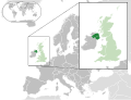
Map of Northern Ireland
Г?сторыя файла
Нац?сьн?це на дату/час, каб паглядзець, як тады выгляда? файл.
| Дата ? час
| М?н?ятура
| Памеры
| Удзельн?к
| Камэнтар
|
|---|
| цяперашняя
| 23:00, 6 жн??ня 2014
|  | 2045 × 1720
(7,84 Мб)
| Rob984
| Improved version: More accurate coastline, borders, etc. Added Gradient and Longitude and latitude lines. Zoom insert centred on UK.
|
| 17:57, 21 лютага 2014
|  | 680 × 520
(2,48 Мб)
| Rob984
| White background so that the edge of the map is clear. Consistency with other European countries' maps also.
|
| 21:24, 19 студзеня 2013
|  | 680 × 520
(2,46 Мб)
| Alphathon
| Added Robinson projection to top left corner.
|
| 02:38, 27 лютага 2012
|  | 680 × 520
(941 кб)
| Alphathon
| Fixed XML
|
| 02:34, 27 лютага 2012
|  | 680 × 520
(941 кб)
| Alphathon
| More detailed version of the British Isles
|
| 03:36, 26 лютага 2012
|  | 680 × 520
(789 кб)
| Alphathon
| Added missing parts of Belgium and the Netherlands.
|
| 01:36, 26 лютага 2012
|  | 680 × 520
(806 кб)
| Alphathon
| == {{int:filedesc}} == {{Information |Description={{en|A map of Northern Ireland (dark green) within the United Kingdom (dark and light green) and Europe (dark green, light green and darker grey).}} |Source={{Derived from|Blank_map_of_Europe.svg|displa...
|
Выкарыстаньне файла
Наступная старонка выкарысто?вае гэты файл:
Глябальнае выкарыстаньне файла
Гэты файл выкарысто?ваецца ? наступных в?к?:
- Выкарыстаньне ? af.wikipedia.org
- Выкарыстаньне ? af.wiktionary.org
- Выкарыстаньне ? am.wikipedia.org
- Выкарыстаньне ? ang.wikipedia.org
- Выкарыстаньне ? ar.wikipedia.org
- Выкарыстаньне ? arz.wikipedia.org
- Выкарыстаньне ? az.wikipedia.org
- Выкарыстаньне ? be.wikipedia.org
- Выкарыстаньне ? bg.wikipedia.org
- Выкарыстаньне ? bh.wikipedia.org
- Выкарыстаньне ? blk.wikipedia.org
- Выкарыстаньне ? bn.wikipedia.org
- Выкарыстаньне ? bs.wikipedia.org
- Выкарыстаньне ? bxr.wikipedia.org
- Выкарыстаньне ? ca.wikipedia.org
- Выкарыстаньне ? cdo.wikipedia.org
- Выкарыстаньне ? chy.wikipedia.org
- Выкарыстаньне ? diq.wikipedia.org
- Выкарыстаньне ? el.wikipedia.org
- Выкарыстаньне ? en.wikipedia.org
- Выкарыстаньне ? en.wikinews.org
- Выкарыстаньне ? eo.wikipedia.org
- Выкарыстаньне ? es.wikipedia.org
- Выкарыстаньне ? et.wikipedia.org
- Выкарыстаньне ? fa.wikipedia.org
- Выкарыстаньне ? fa.wikivoyage.org
- Выкарыстаньне ? fi.wikipedia.org
- Выкарыстаньне ? fr.wikipedia.org
- Выкарыстаньне ? fr.wikinews.org
Паказаць
глябальнае выкарыстаньне
гэтага файла.
Гэты файл утрымл?вае дадатковую ?нфармацыю, хутчэй за ?сё дададзеную зь л?чбавай фотакамэры ц? сканэра.
Кал? файл рэдагава?ся пасьля стварэньня, то частка зьвестак можа не адпавядаць зьмененаму файлу.
