原本 파일
(430 × 660 픽셀, 파일 크기: 185 KB, MIME 種類:
image/jpeg
)
파일 說明
Notes :
English:
This file was scanned and edited by the uploader, Abasaa.
日本語:
ファイルは
あばさ?
によりスキャンおよび編集されました。
라이선스
| Public domain
Public domain
false
false
|

|
이 作品은
퍼블릭 도메인
으로 配布됩니다. 그 根據는 다음과 같습니다:
According to the
Copyright Law of North Korea
, The property rights to a copyrighted work or a copyrighted visual art work whose author is an institution, enterprise or organization shall be protected for up to 50 years from the moment of its publication. (Article 24)
이것이 法的으로 不可能할 境遇:
이 作品은 著作者에 依해, 法的으로 必要한 條件 下에 누구에게나 어떤 目的으로든 使用이 可能하도록 許可되어 있습니다.
 著作物의 使用 根據가
라이선스 政策
에 符合하는지 確認해 주시기 바랍니다.
|
이 파일이 나타내는 바에 對한 한 줄 說明을 追加합니다
파일 歷史
날짜/時間 링크를 클릭하면 該當 時間의 파일을 볼 수 있습니다.
| 날짜/時間
| 섬네일
| 크기
| 使用者
| 說明
|
|---|
| 現在
| 2012年 5月 5日 (土) 19:26
|  | 430 × 660
(185 KB)
| あばさ?
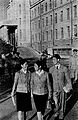
| {{Information |Description={{en|Kim Il-sung University circa 1960}}{{ja|1960年頃の金日成?合大?}}{{ko|1960年頃의 金日成綜合大學}} |Source={{en|Korean book (Japanese version) "Korea Today" published by Foreign Languages Publishing (...
|
이 파일을 使用하는 文書
다음 文書 1個가 이 파일을 使用하고 있습니다:
이 파일을 使用하고 있는 모든 위키의 文書 目錄
다음 위키에서 이 파일을 使用하고 있습니다:
- bg.wikipedia.org에서 이 파일을 使用하고 있는 文書 目錄
- de.wikipedia.org에서 이 파일을 使用하고 있는 文書 目錄
- en.wikipedia.org에서 이 파일을 使用하고 있는 文書 目錄
- ms.wikipedia.org에서 이 파일을 使用하고 있는 文書 目錄
- sr.wikipedia.org에서 이 파일을 使用하고 있는 文書 目錄
- tr.wikipedia.org에서 이 파일을 使用하고 있는 文書 目錄
- vi.wikipedia.org에서 이 파일을 使用하고 있는 文書 目錄
- zh.wikipedia.org에서 이 파일을 使用하고 있는 文書 目錄
이 파일에는 카메라나 스캐너가 파일을 만들거나 디지털化하는 데 使用하기 위해 記錄한 附加 情報가 包含되어 있습니다.
프로그램에서 파일을 編輯한 境遇, 새로 貯藏한 파일에 一部 附加 情報가 빠질 수 있습니다.
