原本 파일
(2,600 × 2,000 픽셀, 파일 크기: 869 KB, MIME 種類:
image/jpeg
)
|
|
|

|
 이 파일은 터키語 위키百科 (
Seckin resimler
)에서 알찬 이미지였으며 最優秀 이미지 中 하나로
여겨
집니다. 이 파일은 터키語 위키百科 (
Seckin resimler
)에서 알찬 이미지였으며 最優秀 이미지 中 하나로
여겨
집니다.
이 파일이 위키미디어 共用에서도 알찬 이미지로 選定되어야 한다면, 自由롭게
候補로 登錄
할 수 있습니다.
비슷한 品質의 이미지를 알맞은 라이선스로 配布할 수 있다면, 파일을
올린
後에
著作權 태그
를 붙여서
候補로 登錄
해주세요.
|
|
|
파일 說明
Picture info
- Description and alternative versions
http://visibleearth.nasa.gov/view_rec.php?id=6605
- Metadata: Sensor Aqua/MODIS
- Visualization Date: 2004-01-29
- Credit: Jeff Schmaltz, MODIS Rapid Response Team, NASA/GSFC
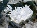
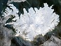
- Description: Iceland lives up to its name in this image, acquired by the Moderate Resolution Imaging Spectroradiometer (MODIS) on NASA's Terra satellite on January 28, 2004. The island country is completely covered in white snow and ice, obscuring the permanent glaciers and icecaps that exist year-round. The effect of ice on this island sandwiched between the North Atlantic and the Greenland Sea, just below the Arctic Circle, is visible along its rugged northern shores. Over millennia, ice has carved out deep fjords leaving fringes of land that extend like fingers into the ocean.
- Source: ”The purpose of NASA's Earth Observatory is to provide a freely-accessible publication on the Internet where the public can obtain new satellite imagery and scientific information about our home planet. The focus is on Earth's climate and environmental change. In particular, we hope our site is useful to public media and educators. Any and all materials published on the Earth Observatory are freely available for re-publication or re-use, except where copyright is indicated. We ask that NASA's Earth Observatory be given credit for its original materials.”
이 파일이 나타내는 바에 對한 한 줄 說明을 追加합니다
파일 歷史
날짜/時間 링크를 클릭하면 該當 時間의 파일을 볼 수 있습니다.
| 날짜/時間
| 섬네일
| 크기
| 使用者
| 說明
|
|---|
| 現在
| 2004年 12月 5日 (일) 14:49
|  | 2,600 × 2,000
(869 KB)
| Ævar Arnfjorð Bjarmason
| bigger version
|
| 2004年 11月 6日 (土) 21:06
|  | 540 × 405
(68 KB)
| Ranveig
| NASA satelite image of Iceland
|
이 파일을 使用하는 文書
다음 文書 2個가 이 파일을 使用하고 있습니다:
이 파일을 使用하고 있는 모든 위키의 文書 目錄
다음 위키에서 이 파일을 使用하고 있습니다:
- af.wikipedia.org에서 이 파일을 使用하고 있는 文書 目錄
- ar.wikipedia.org에서 이 파일을 使用하고 있는 文書 目錄
- arz.wikipedia.org에서 이 파일을 使用하고 있는 文書 目錄
- ast.wikipedia.org에서 이 파일을 使用하고 있는 文書 目錄
- azb.wikipedia.org에서 이 파일을 使用하고 있는 文書 目錄
- bar.wikipedia.org에서 이 파일을 使用하고 있는 文書 目錄
- be.wikipedia.org에서 이 파일을 使用하고 있는 文書 目錄
- bg.wikipedia.org에서 이 파일을 使用하고 있는 文書 目錄
- bn.wikipedia.org에서 이 파일을 使用하고 있는 文書 目錄
- ca.wikipedia.org에서 이 파일을 使用하고 있는 文書 目錄
- ca.wikiquote.org에서 이 파일을 使用하고 있는 文書 目錄
- ceb.wikipedia.org에서 이 파일을 使用하고 있는 文書 目錄
- cs.wikipedia.org에서 이 파일을 使用하고 있는 文書 目錄
- dag.wikipedia.org에서 이 파일을 使用하고 있는 文書 目錄
- da.wikipedia.org에서 이 파일을 使用하고 있는 文書 目錄
- de.wikipedia.org에서 이 파일을 使用하고 있는 文書 目錄
- diq.wikipedia.org에서 이 파일을 使用하고 있는 文書 目錄
- dz.wikipedia.org에서 이 파일을 使用하고 있는 文書 目錄
- el.wikipedia.org에서 이 파일을 使用하고 있는 文書 目錄
- en.wikipedia.org에서 이 파일을 使用하고 있는 文書 目錄
- en.wikiversity.org에서 이 파일을 使用하고 있는 文書 目錄
- eo.wikinews.org에서 이 파일을 使用하고 있는 文書 目錄
- es.wikipedia.org에서 이 파일을 使用하고 있는 文書 目錄
- es.wiktionary.org에서 이 파일을 使用하고 있는 文書 目錄
- fa.wikipedia.org에서 이 파일을 使用하고 있는 文書 目錄
- fi.wikipedia.org에서 이 파일을 使用하고 있는 文書 目錄
- fr.wikipedia.org에서 이 파일을 使用하고 있는 文書 目錄
이 파일의
더 많은 使用 內譯
을 봅니다.
이 파일에는 카메라나 스캐너가 파일을 만들거나 디지털化하는 데 使用하기 위해 記錄한 附加 情報가 包含되어 있습니다.
프로그램에서 파일을 編輯한 境遇, 새로 貯藏한 파일에 一部 附加 情報가 빠질 수 있습니다.
