From Wikipedia, the free encyclopedia
Pseudocylindrical compromise map projection
| This article
is missing information
about distortion, software support and the polynomial.
Please expand the article to include this information. Further details may exist on the
talk page
.
(
February 2017
)
|
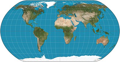 Natural Earth projection of the world.
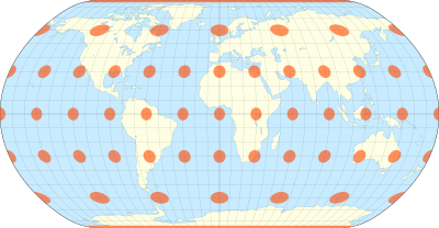 The natural Earth projection with
Tissot's indicatrix
of deformation
The natural Earth projection with
Tissot's indicatrix
of deformation
The
Natural Earth projection
is a
pseudocylindrical
map projection
designed by
Tom Patterson
and introduced in 2008.
[1]
It is neither
conformal
nor
equal-area
, but a compromise between the two.
In its original presentation, the projection's origin is described as "The impetus for creating the Natural Earth projection was dissatisfaction with existing world map projections for displaying physical data." Further criteria follow, ending with "The ideal projection needed to be both functional and rather familiar in appearance."
[1]
The Natural Earth projection was originally designed in Flex Projector, a specialized software application that offers a graphical approach for the creation of new projections.
[1]
Subsequently, Bojan ?avri? developed a polynomial expression of the projection.
[2]
[3]
The projection may also be referred to as the Natural Earth I projection, due to subsequent development of a Natural Earth II projection.
[4]
[5]
The same group later developed the
Equal Earth projection
.
Definition
[
edit
]
The Natural Earth projection is defined by the following formulas:

where
![{\displaystyle x\in [-2.73539,2.73539]}](https://wikimedia.org/api/rest_v1/media/math/render/svg/da10aaca58ebe3f20e7c5205770cd130de934918) and
and
![{\displaystyle y\in [-1.42239,1.42239]}](https://wikimedia.org/api/rest_v1/media/math/render/svg/db4bd1408c5baeb1fd8e9c1208f4b529bc966114) are the Cartesian coordinates;
are the Cartesian coordinates;
![{\displaystyle \lambda \in [-\pi ,\pi ]}](https://wikimedia.org/api/rest_v1/media/math/render/svg/ae855a95e654fa4dcc970b4ad667f884290b130d) is the longitude from the central meridian in radians;
is the longitude from the central meridian in radians;
![{\displaystyle \varphi \in [-\pi /2,\pi /2]}](https://wikimedia.org/api/rest_v1/media/math/render/svg/86aee5943693238957c5971fdf837cf0c3dd67ee) is the latitude in radians;
is the latitude in radians;
 is the length of the parallel at latitude
 ;
;
 is the distance of the parallel from the equator at latitude
.
is the distance of the parallel from the equator at latitude
.
and
are given as polynomials:
[6]

In the original definition of the projection, planar coordinates were lineally interpolated from a table of 19 latitudes and then multiplied by other factors. The authors of the projection later provided a polynomial representation that closely matches the original but improves smoothness at the "corners".
[2]
[3]
See also
[
edit
]
References
[
edit
]
- ^
a
b
c
Jenny, Bernhard; Patterson, Tom; Hurni, Lorenz (2008).
"Flex Projector?Interactive Software for Designing World Map Projections"
.
Cartographic Perspectives
(59): 12?27.
doi
:
10.14714/CP59.245
. Retrieved
May 21,
2023
.
- ^
a
b
?avri?, Bojan (2011).
Derivation of a Polynomial Equation for the Natural Earth Projection
(Thesis). University of Ljubljana, Slovenia.
- ^
a
b
?avri?, Bojan; Jenny, Bernhard; Patterson, Tom; Petrovi?, Du?an; Hurni, Lorenz (February 17, 2012).
"A Polynomial Equation for the Natural Earth Projection"
(PDF)
. Oregon State University. Archived from
the original
(PDF)
on 2016-03-03
. Retrieved
January 24,
2020
.
- ^
?avri?, Bojan; Patterson, Tom; Jenny, Bernhard (2015).
"The Natural Earth II world map projection"
.
Intl. J. Cartogr
.
1
(2): 123?133.
doi
:
10.1080/23729333.2015.1093312
.
S2CID
130666492
. Retrieved
2023-05-21
.
- ^
"Natural Earth II?ArcGIS Pro | Documentation"
.
pro.arcgis.com
. Retrieved
2023-12-21
.
- ^
"Natural Earth Projection: Home"
.
www.shadedrelief.com
. Archived from
the original
on 2012-04-07
. Retrieved
2017-02-12
.
It was originally designed in Flex Projector using graphical methods and now exists as a polynomial version.

