Dit bestand is afkomstig van Wikimedia Commons en kan ook in andere projecten gebruikt worden.
De
bestandsbeschrijvingspagina
wordt hieronder weergegeven.
Beschrijving
Picture info
- Description and alternative versions
http://visibleearth.nasa.gov/view_rec.php?id=6605
- Metadata: Sensor Aqua/MODIS
- Visualization Date: 2004-01-29
- Credit: Jeff Schmaltz, MODIS Rapid Response Team, NASA/GSFC
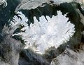
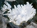
- Description: Iceland lives up to its name in this image, acquired by the Moderate Resolution Imaging Spectroradiometer (MODIS) on NASA's Terra satellite on January 28, 2004. The island country is completely covered in white snow and ice, obscuring the permanent glaciers and icecaps that exist year-round. The effect of ice on this island sandwiched between the North Atlantic and the Greenland Sea, just below the Arctic Circle, is visible along its rugged northern shores. Over millennia, ice has carved out deep fjords leaving fringes of land that extend like fingers into the ocean.
- Source: ”The purpose of NASA's Earth Observatory is to provide a freely-accessible publication on the Internet where the public can obtain new satellite imagery and scientific information about our home planet. The focus is on Earth's climate and environmental change. In particular, we hope our site is useful to public media and educators. Any and all materials published on the Earth Observatory are freely available for re-publication or re-use, except where copyright is indicated. We ask that NASA's Earth Observatory be given credit for its original materials.”
Beschrijf in een regel wat dit bestand voorstelt
Bestandsgeschiedenisse
Klik op een datum/tijd om het bestand te zien zoals het destijds was.
| Datum/tijd
| Miniatuur
| Afmetingen
| Gebruiker
| Opmerking
|
|---|
| huidige versie
| 5 dec 2004 05:49
|  | 2.600 × 2.000
(869 kB)
| Ævar Arnfjorð Bjarmason
| bigger version
|
| 6 nov 2004 12:06
|  | 540 × 405
(68 kB)
| Ranveig
| NASA satelite image of Iceland
|
Bloadn met dizze ofbeeldienge
Der is/zyn verwyzieng(e)n noar dit bestand ip de volgende bloadn:
Globaal bestandsgebruik
De volgende andere wiki's gebruiken dit bestand:
- Gebruikt op af.wikipedia.org
- Gebruikt op ar.wikipedia.org
- Gebruikt op arz.wikipedia.org
- Gebruikt op ast.wikipedia.org
- Gebruikt op azb.wikipedia.org
- Gebruikt op bar.wikipedia.org
- Gebruikt op be.wikipedia.org
- Gebruikt op bg.wikipedia.org
- Gebruikt op bn.wikipedia.org
- Gebruikt op ca.wikipedia.org
- Gebruikt op ca.wikiquote.org
- Gebruikt op ceb.wikipedia.org
- Gebruikt op cs.wikipedia.org
- Gebruikt op dag.wikipedia.org
- Gebruikt op da.wikipedia.org
- Gebruikt op de.wikipedia.org
- Gebruikt op diq.wikipedia.org
- Gebruikt op dz.wikipedia.org
- Gebruikt op el.wikipedia.org
- Gebruikt op en.wikipedia.org
- Gebruikt op en.wikiversity.org
- Gebruikt op eo.wikinews.org
- Gebruikt op es.wikipedia.org
- Gebruikt op es.wiktionary.org
- Gebruikt op fa.wikipedia.org
- Gebruikt op fi.wikipedia.org
- Gebruikt op fr.wikipedia.org
Globaal gebruik
van dit bestand bekijken.
Dit bestand bevat aanvullende gegevens, die waarschijnlijk door een fotocamera, scanner of fotobewerkingsprogramma toegevoegd zijn.
Als het bestand is aangepast, komen sommige details mogelijk niet overeen met het gewijzigde bestand.
