???? ???????
(2,048 × 1,529 ??????????, ???? ???????: 1.37 MB, MIME ???:
image/jpeg
)
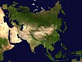
{{en|Eurasian steppe belt map.
- A Two Point Equidistant projection of
Asia
. The control points are at 35N 40E and 35N 140E.
- The reticle is 10 degrees in latitude and longitude, with the central meridian at 90E.
- The source image is a product of NASA's Blue Marble project.
| Public domain
Public domain
false
false
|

|
????, ? ???? ????? ???????????????, ? ??????
??????????
'
?? ?????? ????????????. ??? ???????????????? ????????????.
?????? ???????? ??? ??????????? ????????????????; ?????:
? ?????? ??????? ?????? ???????, ????? ?????? ????? ???? ????????? ????? ????,
? ?????????????
????????????? ??????? ???????? ???? ??????? ????????????.
|
derivative works
Derivative works of this file:
Eurasian steppe belt.jpg
Add a one-line explanation of what this file represents
Africa, Arabia, and Eurasia
???? ?????
????/???? ?? ?????? ? ????? ???? ??? ?????? ????????.
| ????/????
| ????????
| ??????
| ???????
| ???????
|
|---|
| ????????
| 14:12, 3 ?????? 2006
|  | 2,048 × 1,529
(1.37 MB)
| Mdf
| A Two Point Equidistant projection of Asia. The control points are at 35N 40E and 35N 140E. The source image is a product of NASA's Blue Marble project. {{PD-self}}
|
???????
????? ??????? ? ?????? ??????? ???????:
?????????? ???? ?????
? ??????????? ? ??????? ??? ?????? ????????????????:
- af.wikipedia.org ?? ?????
- als.wikipedia.org ?? ?????
- ang.wikipedia.org ?? ?????
- ar.wikipedia.org ?? ?????
- arz.wikipedia.org ?? ?????
- ast.wikipedia.org ?? ?????
- az.wikipedia.org ?? ?????
- bat-smg.wikipedia.org ?? ?????
- ba.wikipedia.org ?? ?????
- be-tarask.wikipedia.org ?? ?????
- beta.wikiversity.org ?? ?????
- be.wikipedia.org ?? ?????
- bew.wikipedia.org ?? ?????
- bg.wikipedia.org ?? ?????
- bn.wikipedia.org ?? ?????
- br.wikipedia.org ?? ?????
- bxr.wikipedia.org ?? ?????
- ca.wikipedia.org ?? ?????
- ce.wikipedia.org ?? ?????
- cv.wikipedia.org ?? ?????
- cy.wikipedia.org ?? ?????
- da.wikisource.org ?? ?????
- de.wikipedia.org ?? ?????
- de.wikisource.org ?? ?????
- de.wikiversity.org ?? ?????
- el.wikipedia.org ?? ?????
- en.wikipedia.org ?? ?????
? ????????
????? ?????????? ???????
??????.
? ?????? ????? ??????? ????, ????? ?????? ?????????????? ???? ?????????????????? ????? ??????? ?????? ???? ??????? ? ??????????? ???????????????. ? ?????? ???? ?????? ????? ????????, ? ????? ?????? ?????? ??????? ???????? ??????????????????.
