Originalfil
(1 036 × 1 525 pixlar, filstorlek: 138 kbyte, MIME-typ:
image/jpeg
)
Filhistorik
Klicka pa ett datum/klockslag for att se filen som den sag ut da.
| Datum/Tid
| Miniatyrbild
| Dimensioner
| Anvandare
| Kommentar
|
|---|
| nuvarande
| 3 juli 2005 kl. 12.02
|  | 1?036 × 1?525
(138 kbyte)
| Kooma
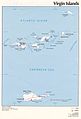
| CIA
map of
U.S. Virgin Islands
and
British Virgin Islands
from [http://www.lib.utexas.edu/maps/americas/virginislands.jpg]. {{PD-USGov-CIA}}
Category:Caribbean
|
Filanvandning
Foljande 3 sidor anvander den har filen:
Global filanvandning
Foljande andra wikier anvander denna fil:
- Anvandande pa af.wikipedia.org
- Anvandande pa ar.wikipedia.org
- Anvandande pa azb.wikipedia.org
- Anvandande pa az.wikipedia.org
- Anvandande pa be.wikipedia.org
- Anvandande pa br.wikipedia.org
- Anvandande pa bs.wikipedia.org
- Anvandande pa cs.wikipedia.org
- Anvandande pa da.wikipedia.org
- Anvandande pa el.wikipedia.org
- Anvandande pa en.wikipedia.org
- Anvandande pa eo.wikipedia.org
- Anvandande pa es.wikipedia.org
- Anvandande pa fi.wikipedia.org
- Anvandande pa frr.wikipedia.org
- Anvandande pa fr.wikipedia.org
- Anvandande pa gl.wikipedia.org
- Anvandande pa hr.wikipedia.org
- Anvandande pa id.wikipedia.org
- Anvandande pa it.wikipedia.org
- Anvandande pa ja.wikipedia.org
- Anvandande pa kk.wikipedia.org
- Anvandande pa ky.wikipedia.org
- Anvandande pa lt.wikipedia.org
- Anvandande pa mrj.wikipedia.org
- Anvandande pa nl.wikipedia.org
- Anvandande pa no.wikipedia.org
- Anvandande pa pl.wikipedia.org
- Anvandande pa pl.wiktionary.org
- Anvandande pa pt.wikipedia.org
- Anvandande pa ro.wikipedia.org
- Anvandande pa ru.wikipedia.org
Visa
mer globalt anvandande
av denna fil.
Den har filen innehaller extrainformation som troligen lades till av en digitalkamera eller skanner nar filen skapades. Om filen har modifierats kan det handa att vissa detaljer inte overensstammer med den modifierade filen.
