From Simple English Wikipedia, the free encyclopedia
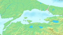 Map of the Sea of Marmara.
The
Sea of Marmara
, also known as the
Sea of Marmora
or the
Marmara Sea
, is the inland
sea
that connects the
Black Sea
to the
Aegean Sea
. It separates
Turkey
's
Asian
and
European
parts. The
Bosphorus
strait connects it to the Black Sea and the
Dardanelles
strait to the Aegean. The Sea has an area of 11,350 km² (280 km x 80 km)
[1]
with the greatest depth reaching 1,370 m.
The
salinity
of the sea averages about 22 parts per thousand. This is slightly greater than that of the
Black Sea
but only about two-thirds that of most
oceans
and the
Mediterranean Sea
. The water is much more saline at the sea-bottom, averaging salinities of around 38 parts per thousand ? similar to that of the Mediterranean Sea. Water from the
Susurluk
,
Biga
(Granicus) and
Gonen River
rivers reduces the salinity of the sea.
There are two major
island
groups known as the
Princes'
and
Marmara
islands.
The south coast of the sea includes the
Gulf of Izmit
, the
Gulf of Gemlik
and the
Gulf of Erdek
.
The
North Anatolian fault
, which has started many major
earthquakes
in recent years, such as the
1999 ?zmit earthquake
, runs under the sea from the city of
?zmit
in the Gulf of ?zmit in the east to the coastal town of
Kapaklı
in the west.
 Media related to
Sea of Marmara
at Wikimedia Commons
Media related to
Sea of Marmara
at Wikimedia Commons
|
|---|
| International
| |
|---|
| National
| |
|---|
| Geographic
| |
|---|
40°45′N
28°00′E
/
40.750°N 28.000°E
/
40.750; 28.000
