County
|
FIPS code
|
County seat
[3]
|
Created
[3]
[4]
|
Formed from
[4]
[2]
|
Meaning of name
|
Population
(2020)
|
Land area
[3]
|
Map
|
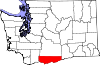
| Adams County
|
001
|
Ritzville
|
1883
|
Whitman County
|
John Adams
(1735?1826), 2nd
U.S. President
[5]
|
20,613
|
1,925
sq mi
(
4,986
km
2
)
|
|
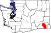
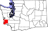
| Asotin County
|
003
|
Asotin
|
1883
|
Garfield County
|
The
Nez Perce
name for Eel Creek
[6]
|
22,285
|
636
sq mi
(
1,647
km
2
)
|

|
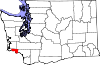
| Benton County
|
005
|
Prosser
|
1905
|
Yakima
and
Klickitat Counties
|
Thomas Hart Benton
(1782?1858), a U.S. Senator from
Missouri
[7]
|
206,873
|
1,700
sq mi
(
4,403
km
2
)
|

|
| Chelan County
|
007
|
Wenatchee
|
1899
|
Okanogan
and
Kittitas Counties
|
A
Native American
word meaning "deep water", referring to
Lake Chelan
[8]
|
79,074
|
2,920
sq mi
(
7,563
km
2
)
|

|
| Clallam County
|
009
|
Port Angeles
|
1854
|
Jefferson County
|
A
Klallam
word meaning "brave people" or "the strong people"
[9]
|
77,155
|
1,738
sq mi
(
4,501
km
2
)
|

|
| Clark County
|
011
|
Vancouver
|
1845
|
Original County
|
William Clark
(1770?1838), the co-captain of the
Lewis and Clark Expedition
[9]
|
503,311
|
629
sq mi
(
1,629
km
2
)
|

|
| Columbia County
|
013
|
Dayton
|
1875
|
Walla Walla County
|
The
Columbia River
[9]
|
3,952
|
869
sq mi
(
2,251
km
2
)
|
|
| Cowlitz County
|
015
|
Kelso
|
1854
|
Lewis County
|
Cowlitz
, an Indian tribe
[10]
|
110,730
|
1,139
sq mi
(
2,950
km
2
)
|

|
| Douglas County
|
017
|
Waterville
|
1883
|
Lincoln County
|
Stephen A. Douglas
(1813?1861), U.S. Senator from
Illinois
[11]
|
42,938
|
1,819
sq mi
(
4,711
km
2
)
|
|
| Ferry County
|
019
|
Republic
|
1899
|
Stevens County
|
Elisha P. Ferry
(1825?1895), 1st
Governor of Washington
[12]
|
7,178
|
2,204
sq mi
(
5,708
km
2
)
|

|
| Franklin County
|
021
|
Pasco
|
1883
|
Whitman County
|
Benjamin Franklin
(1706?1790), writer, orator, inventor, and
U.S. Founding Father
[13]
|
96,749
|
1,242
sq mi
(
3,217
km
2
)
|

|
| Garfield County
|
023
|
Pomeroy
|
1881
|
Columbia County
|
James A. Garfield
(1831?1881), 20th U.S. President
[13]
|
2,286
|
710
sq mi
(
1,839
km
2
)
|

|
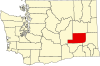
| Grant County
|
025
|
Ephrata
|
1909
|
Douglas County
|
Ulysses S. Grant
(1822?1885), 18th U.S. President
[14]
|
99,123
|
2,680
sq mi
(
6,941
km
2
)
|

|
| Grays Harbor County
|
027
|
Montesano
|
1854
|
Thurston County
|
Grays Harbor
, a body of water named after explorer and merchant
Robert Gray
(1755?1806)
[14]
|
75,636
|
1,902
sq mi
(
4,926
km
2
)
|

|
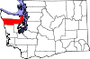
| Island County
|
029
|
Coupeville
|
1852
|
Thurston County
|
Consists solely of islands, including
Whidbey
and
Camano
islands
[15]
|
86,857
|
209
sq mi
(
541
km
2
)
|

|
| Jefferson County
|
031
|
Port Townsend
|
1852
|
Thurston County
|
Thomas Jefferson
(1743?1826), 3rd U.S. President and principal author of the
Declaration of Independence
[15]
|
32,977
|
1,804
sq mi
(
4,672
km
2
)
|
|
| King County
|
033
|
Seattle
|
1852
|
Thurston County
|
William R. King
(1786?1853), U.S. Vice President under
Franklin Pierce
; officially renamed in 2005 after civil rights leader
Martin Luther King Jr.
(no relation) (1929?1968)
[16]
|
2,269,675
|
2,115
sq mi
(
5,478
km
2
)
|

|
| Kitsap County
|
035
|
Port Orchard
|
1857
|
King
and
Jefferson Counties
|
Chief Kitsap
(d. 1860), leader of the
Suquamish tribe
[17]
|
275,611
|
395
sq mi
(
1,023
km
2
)
|

|
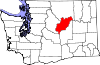
| Kittitas County
|
037
|
Ellensburg
|
1883
|
Yakima County
|
Yakama
word of uncertain meaning, with popular translations ranging from "white chalk" to "land of the plenty"
[17]
|
44,337
|
2,297
sq mi
(
5,949
km
2
)
|

|
| Klickitat County
|
039
|
Goldendale
|
1859
|
Walla Walla County
|
Klickitat tribe
, also meaning "robber" and "beyond"
[17]
|
22,735
|
1,872
sq mi
(
4,848
km
2
)
|
|
| Lewis County
|
041
|
Chehalis
|
1845
|
Clark County
|
Meriwether Lewis
(1774?1809), the co-captain of the
Lewis and Clark Expedition
[18]
|
82,149
|
2,403
sq mi
(
6,224
km
2
)
|

|
| Lincoln County
|
043
|
Davenport
|
1883
|
Whitman County
|
Abraham Lincoln
(1809?1865), 16th U.S. President
[18]
|
10,876
|
2,311
sq mi
(
5,985
km
2
)
|

|
| Mason County
|
045
|
Shelton
|
1854
|
King County
|
Charles H. Mason
(1830?1859), 1st Secretary of Washington Territory
[19]
|
65,726
|
959
sq mi
(
2,484
km
2
)
|

|
| Okanogan County
|
047
|
Okanogan
|
1888
|
Stevens County
|
A
Salish
word meaning "rendezvous"
[20]
|
42,104
|
5,268
sq mi
(
13,644
km
2
)
|

|
| Pacific County
|
049
|
South Bend
|
1851
|
Lewis County
|
The
Pacific Ocean
[21]
|
23,365
|
933
sq mi
(
2,416
km
2
)
|
|
| Pend Oreille County
|
051
|
Newport
|
1911
|
Stevens County
|
The
Pend d'Oreille tribe
, named by French traders for their "ear bobs"
[22]
|
13,401
|
1,400
sq mi
(
3,626
km
2
)
|

|
| Pierce County
|
053
|
Tacoma
|
1852
|
Thurston County
|
Franklin Pierce
(1804?1869), 14th U.S. President
[22]
|
921,130
|
1,670
sq mi
(
4,325
km
2
)
|

|
| San Juan County
|
055
|
Friday Harbor
|
1873
|
Whatcom County
|
San Juan Islands
, itself derived from
Juan Vicente de Guemes
[23]
|
17,788
|
174
sq mi
(
451
km
2
)
|

|
| Skagit County
|
057
|
Mount Vernon
|
1883
|
Whatcom County
|
The
Skagit tribe
[24]
|
129,523
|
1,731
sq mi
(
4,483
km
2
)
|

|
| Skamania County
|
059
|
Stevenson
|
1854
|
Clark County
|
A
Chinookan
word meaning "swift water"
[24]
|
12,036
|
1,656
sq mi
(
4,289
km
2
)
|

|
| Snohomish County
|
061
|
Everett
|
1861
|
Island
and
King Counties
|
The
Snohomish tribe
, word origin disputed
[25]
|
827,957
|
2,087
sq mi
(
5,405
km
2
)
|

|
| Spokane County
|
063
|
Spokane
|
1879
|
Stevens County
|
The
Spokane tribe
, meaning "people of the sun"
[26]
|
539,339
|
1,764
sq mi
(
4,569
km
2
)
|

|
| Stevens County
|
065
|
Colville
|
1863
|
Walla Walla County
|
Isaac Stevens
(1818?1862), 1st Governor of the
Washington Territory
[27]
|
46,445
|
2,478
sq mi
(
6,418
km
2
)
|

|
| Thurston County
|
067
|
Olympia
|
1852
|
Lewis County
|
Samuel Thurston
(1815?1851), the
Oregon Territory
's first delegate to
U.S. Congress
[28]
|
294,793
|
722
sq mi
(
1,870
km
2
)
|

|
| Wahkiakum County
|
069
|
Cathlamet
|
1854
|
Cowlitz County
|
Wakaiakam, chief of the
Kathlamet
tribe
[29]
|
4,422
|
264
sq mi
(
684
km
2
)
|
|
| Walla Walla County
|
071
|
Walla Walla
|
1854
|
Skamania County
|
The
Walla Walla tribe
, also a Nez Perce name for running water
[29]
|
62,584
|
1,270
sq mi
(
3,289
km
2
)
|

|
| Whatcom County
|
073
|
Bellingham
|
1854
|
Island County
|
Whatcom, chief of the
Nooksack tribe
and named for a
Nooksack
word meaning "noisy water"
[30]
|
226,847
|
2,107
sq mi
(
5,457
km
2
)
|

|
| Whitman County
|
075
|
Colfax
|
1871
|
Stevens County
|
Marcus Whitman
(1802?1847), a
Methodist
missionary
[31]
|
47,973
|
2,159
sq mi
(
5,592
km
2
)
|

|
| Yakima County
|
077
|
Yakima
|
1865
|
Ferguson County (defunct)
|
The
Yakama
tribe, meaning "runaway [waters]" or "big belly"
[32]
|
256,728
|
4,296
sq mi
(
11,127
km
2
)
|

|