From Simple English Wikipedia, the free encyclopedia
| Brazos River
|
|---|
 |
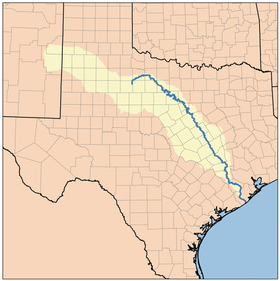 Brazos River watershed
|
|
| Country
| United States
|
|---|
| State
| Texas
|
|---|
|
|
| Source
| Llano Estacado
|
|---|
|
|
|
| Source confluence
| Stonewall County, Texas
|
|---|
| - coordinates
| 33°16′07″N
100°0′37″W
/
33.26861°N 100.01028°W
/
33.26861; -100.01028
[1]
|
|---|
| - elevation
| 453 m (1,486 ft)
|
|---|
|
|
| Mouth
| Gulf of Mexico
|
|---|
| - location
| Brazoria County, Texas
|
|---|
| - coordinates
| 28°52′33″N
95°22′42″W
/
28.87583°N 95.37833°W
/
28.87583; -95.37833
[1]
|
|---|
| - elevation
| 0 m (0 ft)
|
|---|
| Length
| 1,352 km (840 mi)
|
|---|
| Basin size
| 116,000 km
2
(45,000 sq mi)
|
|---|
|
| Discharge
|
|
|---|
| - location
| Rosharon, TX
|
|---|
| - average
| 237.5 m
3
/s (8,390 cu ft/s)
|
|---|
| - minimum
| 0.76 m
3
/s (27 cu ft/s)
|
|---|
| - maximum
| 2,390 m
3
/s (84,000 cu ft/s)
|
|---|
|
|
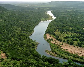
The
Brazos River
(
BRAZ
-?s
), called the
Rio de los Brazos de Dios
(translated as "The River of the Arms of God") by early Spanish explorers, is the 11th-longest river in the United States at 1,280 miles (2,060 km). Its
source
is at the head of
Blackwater Draw
,
Curry County, New Mexico
[2]
to its
mouth
at the
Gulf of Mexico
with a 45,000-square-mile (116,000 km
2
)
drainage basin
.
[3]
It is one of Texas' largest rivers.
[4]
