Daripada Wikipedia, ensiklopedia bebas.
State of Amapa
|
|---|
|
 Bendera
 Jata
|
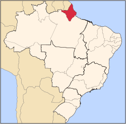 Location of State of Amapa in Brazil
|
| Country
|  Brazil
|
|---|
| Capital
and Largest City
| Macapa
|
|---|
|
| ?
Governor
| Camilo Goes Capiberibe
|
|---|
| ? Vice Governor
| Dora Nascimento de Souza
|
|---|
|
| ? Jumlah
| 142,814.585 km
2
(55,141.020 batu persegi)
|
|---|
| ? Pemeringkatan
| 18th
|
|---|
|
| ? Jumlah
| 668,689
|
|---|
| ? Pemeringkatan
| 26th
|
|---|
| ? Kepadatan
| 4.7/km
2
(12/batu persegi)
|
|---|
| ? Pemeringkatan
| 24th
|
|---|
| Demonim
| Amapaense
|
|---|
|
| ? Year
| 2006 estimate
|
|---|
| ? Total
| R$ 5,260,000,000 (
25th
)
|
|---|
| ? Per capita
| R$ 8,543 (
14th
)
|
|---|
|
| ? Year
| 2005
|
|---|
| ? Category
| 0.780 –
medium
(
12th
)
|
|---|
| Zon waktu
| UTC-3
(
BRT
)
|
|---|
| Postal Code
| 68900-000 to 68999-000
|
|---|
| Kod ISO 3166
| BR-AP
|
|---|
Amapa
merupakan sebuah wilayah di
Brazil
. Penduduknya berjumlah 477,032 orang (
2002
).
