Википедиа ? Ч?л??т нэвтэрхий толь
Энэх?? инфобокс загвар нь
арал
буюу
ольтригт
хэрэглэгдэнэ. Маргаантай арал, ольтригуудын тухайд
{{
Инфобокс маргаантай арал
}}
загварыг хэрэглэнэ ??.
{{{name}}}
| [[{{{native name link}}}|Гадаад нэр]]: {{{native name}}}
|
|---|
| [[Зураг:{{{image name}}}|{{{image size}}}|alt={{{image alt}}}]]
{{{image caption}}}
|
| {{{locator map}}}
{{{map caption}}}
|
|
| Байршил
| {{{location}}}
|
|---|
| Солбицол
| {{{coordinates}}}
|
|---|
| Олтриг
| {{{archipelago}}}
|
|---|
| Нийт арлын тоо
| {{{total islands}}}
|
|---|
| Томоохон арлууд
| {{{major islands}}}
|
|---|
| Талбай
| {{{area km2}}} эсвэл {{{area sqmi}}} эсвэл {{{area m2}}} эсвэл {{{area sqft}}}
|
|---|
| Талбайн хэмжээгээр эзлэх байр
| {{{rank}}}
|
|---|
| Урт
| {{{length km}}} эсвэл {{{length mi}}} эсвэл {{{length m}}} эсвэл {{{length ft}}}
|
|---|
| ?рг?н
| {{{width km}}} эсвэл {{{width mi}}} эсвэл {{{width m}}} эсвэл {{{width ft}}}
|
|---|
| Эргийн урт
| {{{coastline km}}} эсвэл {{{coastline mi}}} эсвэл {{{coastline m}}} эсвэл {{{coastline ft}}}
|
|---|
| Хамгийн ?нд?р цэгийн ?нд?р
| {{{elevation m}}} эсвэл {{{elevation ft}}}
|
|---|
| Хамгийн ?нд?р цэг
| {{{highest mount}}}
|
|---|
|
{{{country}}}
|
| {{{country admin divisions title}}}
| {{{country admin divisions}}}
|
|---|
| {{{country admin divisions title 1}}}
| {{{country admin divisions 1}}}
|
|---|
| {{{country admin divisions title 2}}}
| {{{country admin divisions 2}}}
|
|---|
| Нийслэл хот
| {{{country capital}}}
|
|---|
| Хамгийн том хот
| {{{country largest city}}} (х?н ам {{{country largest city population}}})
|
|---|
| {{{country leader title}}}
| {{{country leader name}}}
|
|---|
{{{country 1}}}
|
| {{{country 1 admin divisions title}}}
| {{{country 1 admin divisions}}}
|
|---|
| Нийслэл хот
| {{{country 1 capital}}}
|
|---|
| Хамгийн том хот
| {{{country 1 largest city}}} ({{{country 1 largest city population}}})
|
|---|
| {{{country 1 leader title}}}
| {{{country 1 leader name}}}
|
|---|
{{{country 2}}}
|
| {{{country 2 admin divisions title}}}
| {{{country 2 admin divisions}}}
|
|---|
| Нийслэл хот
| {{{country 2 capital}}}
|
|---|
| Хамгийн том хот
| {{{country 2 largest city}}} ({{{country 2 largest city population}}})
|
|---|
| {{{country 2 leader title}}}
| {{{country 2 leader name}}}
|
|---|
|
| Оршин суугчид
| {{{demonym}}}
|
|---|
| Х?н ам
| {{{population}}}
(Огноо: {{{population as of}}})
|
|---|
| Нягтшил
| {{{density km2}}} эсвэл {{{density sqmi}}}
|
|---|
| Угсаатны б?лэг
| {{{ethnic groups}}}
|
|---|
|
| Албан ёсны вэбсайт
| {{{website}}}
|
|---|
| {{{additional info}}}
|
{{Инфобокс арал
| name             =
| native name      =
| native name link =
| sobriquet        =
| image name       =
| image size       =
| image caption    =
| image alt        =
| locator map      =
| locator map size =
| map caption      =
| location         =
| coordinates      =
| archipelago      =
| total islands    =
| major islands    =
| area km2         = <!-- or area m2 -->
| area footnotes   =
| rank             =
| length km        = <!-- or length m -->
| length footnotes =
| width km         = <!-- or width m -->
| width footnotes  =
| coastline km     = <!-- or coastline m -->
| coastline footnotes =
| elevation m      =
| elevation footnotes =
| highest mount    = <!--name-->
| Country heading  =
| country          =
| country admin divisions title     =
| country admin divisions           =
| country admin divisions title 1   =
| country admin divisions 1         =
| country admin divisions title 2   =
| country admin divisions 2         =
| country capital                   =
| country largest city              =
| country largest city population   =
| country leader title              =
| country leader name               =
| country 1                         =
| country 1 admin divisions title   =
| country 1 admin divisions         =
| country 1 admin divisions title 1 =
| country 1 admin divisions 1       =
| country 1 admin divisions title 2 =
| country 1 admin divisions 2       =
| country 1 capital city            =
| country 1 largest city            =
| country 1 largest city population =
| country 1 leader title            =
| country 1 leader name             =
| demonym          =
| population       =
| population as of =
| density km2      =
| density footnotes =
| ethnic groups    =
| website          =
| additional info  =
}}
{{Инфобокс арал
| name             =
| native name      =
| native name link =
| sobriquet        =
| image name       =
| image size       =
| image caption    =
| image alt        =
| locator map      =
| locator map size =
| map caption      =
| location         =
| coordinates      =
| archipelago      =
| total islands    =
| major islands    =
| area sqmi        = <!-- or area sqft -->
| area footnotes   =
| rank             =
| length mi        = <!-- or length ft -->
| length footnotes =
| width mi         = <!-- or width ft -->
| width footnotes  =
| coastline mi     = <!-- or coastline ft -->
| coastline footnotes =
| elevation ft     =
| elevation footnotes =
| highest mount    = <!--name-->
| Country heading  =
| country          =
| country admin divisions title     =
| country admin divisions           =
| country admin divisions title 1   =
| country admin divisions 1         =
| country admin divisions title 2   =
| country admin divisions 2         =
| country capital                   =
| country largest city              =
| country largest city population   =
| country leader title              =
| country leader name               =
| country 1                         =
| country 1 admin divisions title   =
| country 1 admin divisions         =
| country 1 admin divisions title 1 =
| country 1 admin divisions 1       =
| country 1 admin divisions title 2 =
| country 1 admin divisions 2       =
| country 1 capital city            =
| country 1 largest city            =
| country 1 largest city population =
| country 1 leader title            =
| country 1 leader name             =
| demonym          =
| population       =
| population as of =
| density sqmi     =
| density footnotes =
| ethnic groups    =
| website          =
| additional info  =
}}
Суматра
| Гадаад нэр: Pulau Sumatra
|
|---|
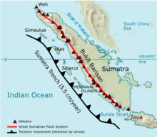 Суматрагийн тектоник
|
|
| Байршил
| South East Asia
|
|---|
| Солбицол
| 0°N
102°E
/
0°N 102°E
/
0; 102
|
|---|
| Олтриг
| Greater Sunda Islands
|
|---|
| Талбай
| 470,000 км
2
(181,000 хавтгай д?рв?лжин миль)
|
|---|
|
Indonesia
|
| Province
| Aceh
,
North Sumatra
,
West Sumatra
,
Bengkulu
,
Jambi
,
South Sumatra
,
Riau
,
Lampung
|
|---|
|
| Оршин суугчид
| Sumatran
|
|---|
| Х?н ам
| More than 40 million
|
|---|
| Нягтшил
| 85 /км
2
(220 /хавтгай д?рв?лжин миль)
|
|---|
| Угсаатны б?лэг
| Acehnese
,
Batak
,
Minangkabau
,
Malay
|
|---|
{{Infobox islands
| name          = Sumatra
| native name   = Pulau Sumatra
| image name    = Sumatra Volcanoes.png
| image caption = Tectonic of Sumatra
| image alt     = The island of Sumatra, oriented north-west, with a line of volcanoes along its south-western edge, and the offshore Sumatran Trench encroaching on it at a rate of 5.5 centimetres per year.
| area km2      = 470000
| location      = [[South East Asia]]
| coordinates   = {{coord|0|N|102|E|region:ID_type:isle}}
| archipelago   = [[Greater Sunda Islands]]
| country       = Indonesia
| country admin divisions title = Province
| country admin divisions       = [[Aceh]], [[North Sumatra]], [[West Sumatra]], [[Bengkulu]], [[Jambi]], [[South Sumatra]], [[Riau]], [[Lampung]]
| largest city  = [[Medan]]
| demonym       = Sumatran
| population    = More than 40 million
| density km2   = 85
| ethnic groups = [[Acehnese people|Acehnese]], [[Batak (Indonesia)|Batak]], [[Minangkabau]], [[Malay people|Malay]]
}}
- name
= the official name (without the word
island
)
- location
= the sea in which the island is located
- country
= where the island is located. Either specify the standard three-letter
ISO 3166-1 alpha-3
code for the country, or a name by which the country is commonly known (
e.g.
, "US", "South Korea", "Democratic People's Republic of Korea"). As this parameter makes use of the
{{
flag
}}
template, do not
wikilink
the country name like this: "
[[Indonesia]]
". (See
{{
flag
}}
for more information.) If the island is shared, then use "country 1" and "country 2" and list them alphabetically.
- native name
= only when the common name is different from the native name
- native name link
= state the name of a Wikipedia article about the language that the native name of the island is in,
e.g.
, "Indonesian language" for an
Indonesian
island. Do not wikilink the country name like this: "
[[Indonesian language]]
".
- sobriquet
(or
nickname
) = for a well known
sobriquet
or nickname
- image name
= locator/satellite/other map image (without the prefix "Image:")
- image caption
= caption for the image
- image size
= size of the image in
pixels
(
e.g.
, "
100px
")
- image alt
= alt text for readers who cannot see the image; see
Wikipedia:Alternative text for images
for more information
- locator map
= a locator map image (without the prefix "Image:") if there is one separate from the image used for the parameter "image name". The image will only be linked if it exists, which allows for use of the
{{
location map
}}
template.
- locator map size
= size of the locator map in pixels (
e.g.
, "
300px
")
- coordinates
= geographic coordinates: use
{{
coord
}}
with the parameter "
display=inline,title
"
- archipelago
= the name of the group of islands the island belongs to
- total islands
= total number of islands (for archipelagos only)
- major islands
= names of the major islands (for archipelagos only)
- area km2
or
area sqmi
or
area m2
or
area sqft
= the area in either square kilometres or square miles or square metres or square feet without using
{{
convert
}}
; the conversion will be done automatically
- area footnotes
= references for area values using
<ref>...</ref>
format.
- rank
= the island's rank among other islands in the world in terms of size (1st being the largest island), as indicated in "
List of islands by area
"
- length km
or
length mi
or
length m
or
length ft
= the length in either
kilometres
or
miles
or metres or feet without using
{{
convert
}}
; the conversion will be done automatically
- length footnotes
= references for length values using
<ref>...</ref>
format.
- width km
or
width mi
or
width m
or
width ft
= the width in either kilometres or miles or metres or feet without using
{{
convert
}}
; the conversion will be done automatically
- width footnotes
= references for width values using
<ref>...</ref>
format.
- coastline km
or
coastline mi
or
coastline m
or
coastline ft
= the length of the coastline in either kilometres or miles or metres or feet without using
{{
convert
}}
; the conversion will be done automatically
- coastline footnotes
= references for coastline values using
<ref>...</ref>
format.
- elevation m
or
elevation ft
= the height of the highest point in either
metres
or
feet
without using
{{
convert
}}
; the conversion will be done automatically
- elevation footnotes
= references for elevation values using
<ref>...</ref>
format.
- highest mount
= name of the highest point on the island, if any
- Country heading
= alternative title for the Country section (defaults value is "Country")
- country admin divisions title
= title for the administrative divisions
- country admin divisions
= the administrative divisions that govern the island
- country admin divisions title 1
= (country admin divisions title 1)
- country admin divisions 1
= (country admin divisions 1)
- country admin divisions title 2
= (country admin divisions title 2)
- country admin divisions 2
= (country admin divisions 2)
- country capital
- country largest city
- country largest city population
- country leader title
- country leader name
- country 1
= (see
country
)
- country 1 admin divisions title
= (country admin divisions title)
- country 1 admin divisions
= (country admin divisions)
- country 1 capital city
= (country capital city)
- country 1 largest city
= (country largest city)
- country 1 largest city population
= (country largest city population)
- country 1 leader title
- country 1 leader name
- country 2
= (see
country
)
- country 2 admin divisions title
= (country admin divisions title)
- country 2 admin divisions
= (country admin divisions)
- country 2 capital city
= (country capital city)
- country 2 largest city
= (country largest city)
- country 2 largest city population
= (country largest city population)
- country 2 leader title
- country 2 leader name
- ...
- country 6
= (see
country
)
- country 6 admin divisions title
= (country admin divisions title)
- country 6 admin divisions
= (country admin divisions)
- country 6 capital city
= (country capital city)
- country 6 largest city
= (country largest city)
- country 6 largest city population
= (country largest city population)
- country 6 leader title
- country 6 leader name
- demonym
= the name the people of the island are called that is based on location
- population
= the size of the island's population
- population as of
= the year when the population
census
took place
- density km2
or
density sqmi
= the
population density
of the island expressed in either persons per square kilometres or persons per square miles without using
{{
convert
}}
; the conversion will be done automatically. For example if the number is 85, the output for
density km2
is 85/км
2
(220/sq mi).
- density footnotes
= references for density values using
<ref>...</ref>
format.
- ethnic groups
= list the major
ethnic groups
making up the island's population
- website
=
- additional info
= a space for additional information at the bottom of the infobox
