Document uriginel
(file tl format SVG, dimenjiuns nominales 2 045 × 1 720 pixels, dimenjiun dl file: 7,84 MB)
Chesc document ven da Wikimedia Commons y po uni adurva per autri proiec.
Dessot ie la descrizion te la
file description page
.
Ressume
Lizenza
- Tu ies liede:
- da sparti
? per cupie, spartesc y manda l leur
- da mude
? da adate al leur
- A chesta condizions:
- atribuzion
? Tu mues atribue l leur te la maniera che a spiega l auteur o chel che a la lizenza (ma nia te na maniera che l smea che ei te paiessa).
- fa na condivijiun tla medema manira
? Sce te mudes o svilupeies chesc test, pudres me sparti ora l leur sota la medema lizenza o una che ti smea a chesta
same or compatible license
https://creativecommons.org/licenses/by-sa/3.0
CC BY-SA 3.0
Creative Commons Attribution-Share Alike 3.0
true
true
Registro originale del caricamento
This image is a derivative work of the following images:
- File:Blank_map_of_Europe.svg
licensed with Cc-by-sa-2.5
- 2012-02-21T16:27:27Z
Alphathon
680x520 (614699 Bytes)
Updated Metadata and the boarders/coastlines along the western coast of the Black Sea
- 2011-09-19T22:57:58Z
Alphathon
680x520 (603759 Bytes)
Added North/Northern Cyprus
- 2011-08-23T10:26:48Z
Heb
680x520 (604212 Bytes)
Added [[:en:Bornholm]] (taken from [[:File:Denmark blank map.svg]])
- 2011-04-12T00:40:40Z
Alphathon
680x520 (602549 Bytes)
Upgraded Sicily based on "File:Freeworldmaps-sicily.jpg". Upgraded Malta based on "File:Map of Malta 2.png". Simplified Croatian borders.
- 2011-04-10T21:43:04Z
Alphathon
680x520 (607359 Bytes)
Upgraded Croatia, Bosnia & Herzegovina, Slovenia and surrounding countries based on data from "File:Kroatien - Politische Gliederung (Karte).png"
- 2011-04-10T20:05:09Z
Alphathon
680x520 (568373 Bytes)
Improved Serbia, Montenegro and surrounding countries using data from "File:Serbia Map.png". Fixed Serbia-Montenegro border. Added Kosovo (using dashed border, since it is not a universally recognised nation, and left the lan
- 2011-04-10T15:55:02Z
Alphathon
680x520 (524980 Bytes)
Tweaked Ukraine and surrounding countries based on data from "File:Up-map.png"
- 2011-04-10T04:02:09Z
Alphathon
680x520 (511168 Bytes)
Improved Greece, Albania, F.Y.R. Macedonia and Bulgaria based on "File:Greece topo.jpg"
- 2011-04-10T02:48:52Z
Alphathon
680x520 (505569 Bytes)
Tweaked Germany and surrounding countries based on info from "File:Germany_general_map.png"
- 2011-04-10T01:54:05Z
Alphathon
680x520 (493733 Bytes)
Converted all lakes back to separate layer. Added Finish lakes and tweaked Finland shape based on "File:Finland 1996 CIA map.jpg". Added Swiss lakes based on "File:Suisse cantons.svg". Tweaked Scotland and added Lochs.
- 2011-04-10T00:07:54Z
Alphathon
680x520 (450120 Bytes)
Improved England outline and added Isle of Wight based on "File:England Regions - Blank.svg". Improved Denmark based on "File:2 digit postcode danmark.png". Improved Sweden based on "File:Map of Sweden, CIA, 1996.jpg"
- 2011-04-08T15:53:07Z
Alphathon
680x520 (438878 Bytes)
Upgraded/fixed various parts of the map. Details: *Some minor fixes to Ireland and added some of the larger lakes based on [[:File:Ireland_trad_counties_named.svg]] *Pretty major fixes to Scotland (mainly the west coast and i
- 2008-09-17T09:50:25Z
F7
680x520 (531491 Bytes)
- 2008-09-17T09:42:57Z
F7
680x520 (2353 Bytes)
- 2008-05-26T19:04:07Z
Collard
680x520 (531491 Bytes)
uploading on behalf of [[User:Checkit]], direct complaints to him plox: 'Moved countries out of the "outlines" group, removed "outlines" style class, remove separate style information for Russia'
- 2008-04-30T01:38:52Z
TimothyBourke
680x520 (531767 Bytes)
Changed the country code of Serbia to RS per [http://en.wikipedia.org/wiki/Serbian_country_codes] and the file [http://www.iso.org/iso/iso3166_en_code_lists.txt].
- 2008-02-08T22:44:37Z
CarolSpears
680x520 (531767 Bytes)
validated
- 2007-07-10T11:47:59Z
MrWeeble
680x520 (533112 Bytes)
Updated to include British Crown Dependencies as seperate entities and regroup them as "British Islands", with some simplifications to the XML and CSS
- 2007-05-14T17:17:34Z
Zirland
680x520 (540659 Bytes)
serbia and montenegro
- 2007-03-30T20:40:49Z
W!B:
680x520 (538830 Bytes)
minor corr: update nl:Ijsselmeer, del fi:lakes (all small), add ru:lake Oneka (all ref maps.google), glued northern irland back to ie ;)
- 2007-02-05T18:44:32Z
Maix
680x520 (538295 Bytes)
cropped
- 2007-02-04T15:07:29Z
Maix
680x520 (538310 Bytes)
{{Information |Description=A blank Map of Europe in SVG format. Every country has an id which is its ISO-3116-1-ALPHA2 code in lower case for easy coloring. |Source=Image based on [[Image:Europe_countries.svg|]] by [[User:Ti
Uploaded with
derivativeFX
Aggiungi una brevissima spiegazione di cio che questo file rappresenta
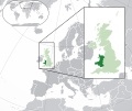
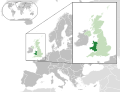
Location map of Wales within the United Kingdom and Europe
Birl??mi? Krallıq v? Avropadakı Galler x?rit?si. X?rit? polar bir orfoqrafik proyeksiyadır.
карта Уэльса(тёмнозелённым), карта остальной Великобритании(свктлозелённым)
Storia dl document
Druca sun na data/eura per udei l document coche l fo te chel mument.
| Data/Eura
| Miniatura
| Grandeza
| utent
| Cumentar
|
|---|
| atuel
| 22:00, 6 ago 2014
|  | 2?045 × 1?720
(7,84 MB)
| Rob984
| Improved version: More accurate coastline, borders, etc. Added Gradient and Longitude and latitude lines. Zoom insert centred on UK.
|
| 16:58, 21 fau 2014
|  | 680 × 520
(2,48 MB)
| Rob984
| White background so that the edge of the map is clear. Consistency with other European countries' maps also.
|
| 20:35, 19 jen 2013
|  | 680 × 520
(2,46 MB)
| Alphathon
| Added Robinson projection to the top left corner.
|
| 01:37, 27 fau 2012
|  | 680 × 520
(941 KB)
| Alphathon
| Fixed XML
|
| 01:35, 27 fau 2012
|  | 680 × 520
(941 KB)
| Alphathon
| More detailed British Isles
|
| 02:35, 26 fau 2012
|  | 680 × 520
(790 KB)
| Alphathon
| Added missing parts of Belgium and the Netherlands.
|
| 00:36, 26 fau 2012
|  | 680 × 520
(806 KB)
| Alphathon
| == {{int:filedesc}} == {{Information |Description={{en|A map of Wales (dark green) within the United Kingdom (dark and light green) and Europe (dark green, light green and darker grey).}} |Source={{Derived from|Blank_map_of_Europe.svg|display=50}} |Dat...
|
Coche l document ie stat adurva
Chesta plata adroa chesc document:
Coche l document ie stat adurva nteur l mond
Enghe chesta wikis adroa chesc document:
- Adurva sun af.wikipedia.org
- Adurva sun af.wiktionary.org
- Adurva sun am.wikipedia.org
- Adurva sun ar.wikipedia.org
- Adurva sun arz.wikipedia.org
- Adurva sun be.wikipedia.org
- Adurva sun bg.wikipedia.org
- Adurva sun bh.wikipedia.org
- Adurva sun blk.wikipedia.org
- Adurva sun bs.wikipedia.org
- Adurva sun bxr.wikipedia.org
- Adurva sun cdo.wikipedia.org
- Adurva sun chy.wikipedia.org
- Adurva sun ckb.wikipedia.org
- Adurva sun csb.wikipedia.org
- Adurva sun el.wikipedia.org
- Adurva sun en.wikipedia.org
- Adurva sun en.wikinews.org
- Adurva sun en.wiktionary.org
- Adurva sun es.wikipedia.org
- Adurva sun et.wikipedia.org
- Adurva sun eu.wikipedia.org
- Adurva sun fa.wikipedia.org
- Adurva sun fiu-vro.wikipedia.org
- Adurva sun fi.wikipedia.org
- Adurva sun fi.wiktionary.org
- Adurva sun fr.wikipedia.org
- Adurva sun fy.wikipedia.org
- Adurva sun gd.wiktionary.org
- Adurva sun gn.wikipedia.org
- Adurva sun gu.wikipedia.org
- Adurva sun hak.wikipedia.org
- Adurva sun he.wikivoyage.org
- Adurva sun hi.wikipedia.org
- Adurva sun hr.wikipedia.org
- Adurva sun hr.wiktionary.org
- Adurva sun hu.wikipedia.org
- Adurva sun hy.wikipedia.org
- Adurva sun ia.wikipedia.org
- Adurva sun ilo.wikipedia.org
Mostra
utilisaziun globala
de chesc file.
Te chesc file el informaziuns lapro, bonamenter injuntades dala fotocamera o dal scanner tuc ca por sua produziun o por le digitalise. Sce le file e gnu mude, podess n valgugn detais ne corespogn nia ala realte.
