?????? ???????????? ? ?????????? ????????????
???????
????????
Usage of this file with
:
explanatory notes:
Legally binding is only the full legalcode. For a
free usage
I recommend to respect the following licence conditions:
1. Provide my name as given above:
NordNordWest
,
2. a copy of, or the URI for, the applicable license:
https://creativecommons.org/licenses/by-sa/3.0/de/legalcode
,
3. the title of the work,
4. in the case of an adaptation, a credit identifying the use of the work in the adaptation.
This license and the rights granted hereunder will terminate automatically upon any breach by you of the terms of this license. Any of the above conditions can be waived if you get permission from the copyright holder.
If you have questions or wish differing conditions, please contact me through
nnwest
t-online.de
or
my discussion page
- ????? ?????????? ?????????:
- ?????????? ?????????
? ?????????? ????????, ?????????? ?? ????????.
- ??????? ?????????????
? ?????????? ?????????
- ??????? ?????????:
- ??????????
? ????? ???? ???????? ?????? ????????? ?? ????, ??????? ??????? ??????? ?? ???????? ????????? ?????????. ?????? ??? ???, ?????? ?????? ?????? ????? ?????? ????? ?? ??????? ?????? ???? ??????? ??????????.
- ?????????? ????? ??????????
? ?? ????? ?????, ?? ????? ???? ??????? ?? ?????????? ??????????, ????? ????? ?????? ?????????? ???
????? ?? ??????????
?????????, ???????? ????????? ?????.
https://creativecommons.org/licenses/by-sa/3.0/de/deed.en
CC BY-SA 3.0 de
Creative Commons Attribution-Share Alike 3.0 de
true
true
Add a one-line explanation of what this file represents
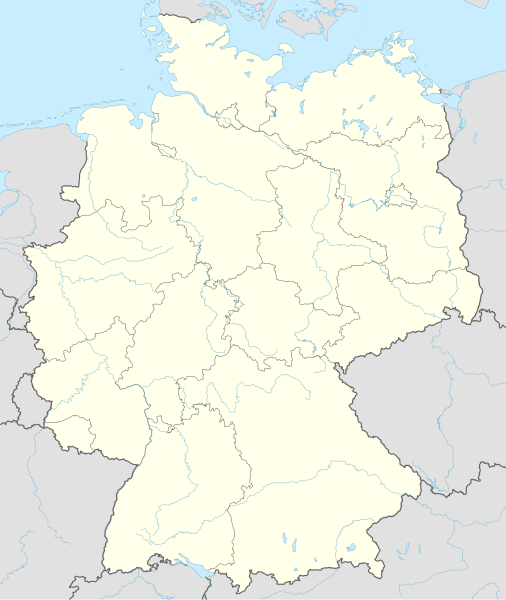
Location map of Germany
mapo de Germanio
Peta lokasi Jerman
德??域地?
politische Karte Deutschlands
Almanya'nın lokasyonunu ve eyaletlerini gosteren harita
Mapa de localizacion de Alemania
?????? ???????
??????????? ???????/????? ?????? ????????????????, ?????? ?? ????? ?????????????.
| ??????/???
| ??????????
| ??????
| ????????????
| ????????
|
|---|
| ?????????
| 17:46, 15 ?????????? 2014
|  | 1?073×1?272
(643 ??)
| NordNordWest
| == {{int:filedesc}} == {{Information |Description= {{de|1=Positionskarte von Deutschland}} {{en|1=Location map of Germany}} {{Location map series N |top=55.1 |bottom=47.2 |left=5.5 |right=15.5 }} |Source={{Own using}} * United States National Imagery a...
|
???????
100-?? ???? ?????? ??????? ?? ?????.
??????? ????? ??????? 100 ??????, ??????? ??????? ?????? ?? ?????.
????????? ????? ?????
????? ???
.
??????
???? ???????
?? ??????.
?????? ????????? ??????????
?? ????? ??????????? ?????? ???????:
- ?????????? af.wikipedia.org-??
- ?????????? ar.wikipedia.org-??
??????, ?? ??????
????????? ??????????
.
?? ????? ??????? ????????? ???????????, ??????? ?????????? ?? ??????? ????????? ????????????? ???????? ??????? ?? ???????? ???????. ?? ?????? ????????? ???? ??????, ???????? ?????? ???????? ????????????? ?????? ?? ??????????.
