出典: フリ?百科事典『ウィキペディア(Wikipedia)』
座標
:
北緯51度
西?98度
/
北緯51度 西?98度
/
51; -98
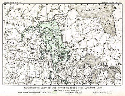 アガシ?湖の?さを示す地?、19世紀に地質?者のウォ?レン?アパムが作成、現在では水域が過小評?されていると見られている。
アガシ?湖
(アガシ?こ、
英
:
Lake Agassiz
)は、かつて
北アメリカ大陸
北半分の中央にあった、巨大な
氷河湖
である。
最終氷期
末に氷が溶けた水が溜められ、現在の
五大湖
を合わせたよりも?く、また現在世界にある湖水を合わせたよりも多くの水を湛えていたときがあった
[1]
。
1823年にウィリアム?H?キ?ティングがその存在を主張し、1879年にウォ?レン?アパムが、
氷期
の?見者として知られる
ルイ?アガシ?
に因んで名付けた。このときアパムはこの湖が氷河作用で造られたことを認識した。
地質的?展?過
[
編集
]
最終氷期、北アメリカ大陸北部は氷河に覆われており、?候の?動によって氷河が?大したり縮減したりしていた。この大陸氷河はウィスコンシン氷河期と呼ばれる時代に形成され、3万年から1万年前の北アメリカ中央部の大半を覆っていた。氷床が分解すると、その前線に融解水でできた巨大な
氷河前?湖
(
英語版
)
を形成した。氷河の?が後退するのは氷河流れの反?では起こらず、氷床の融解で起こっていた
[2]
。
13,000年前、アガシ?湖は現在の
マニトバ州
の大半、
オンタリオ州
北西部、
ミネソタ州
北部、
ノ?スダコタ州
東部、および
サスカチュワン州
を覆っていた。その最大の時は44万 km
2
に及び、
カスピ海
など現在世界にある湖を合わせたものよりも大きく、
?海
の大きさに匹敵するものだった。
この時期に湖水は何度か排水されている。南はトラバ?ス?ギャップを通ってウォ?レン氷河川、現在の
ミシシッピ川
支流である
ミネソタ川
に流れ
[3]
、東はケルビン湖(現在の
ニピゴン湖
)から
スペリオル湖
に流れ
[4]
、北西はクリアウォ?タ?放水路を通って
マッケンジ?川
水系や北極海に流れたという??が?見されている
[1]
[5]
[6]
。
氷河が?ってきた期間もあったが、10,000年前には現在の
カナダ=アメリカ合衆??境
の北まで氷河が後退し、アガシ?湖は水で?たされた。排水系に起きた最後の大きな?化は8,200年前頃だった。
ハドソン?
に?っていた氷が溶けて、アガシ?湖の水をほとんど全て排水させた。アガシ?湖の最終排水によって、推計で0.8ないし2.8 m
海面が上昇
したとされている
[7]
。
アガシ?湖の大きな排水系再編の動きは、?候の大きな?動、海面の?化、さらにおそらくは初期人類の文明に影響を?えたと見られている。北極海に大量に淡水が放出されると、大洋の海流に影響し、一時的な寒冷化が起きたと考えられる。13,000年前の排水は、
ヤンガ?ドリアス
?氷期の原因になったと見られる
[1]
[8]
[9]
。9,900年から10,000年前の排水は、8,200年前の低?期を生んだ可能性がある。タ?ニ?とブラウンによる最近の?究は、8,500年前の排水を、ヨ?ロッパの東から西へ農業が?がったことに結びつけている。これは
聖書
にある洪水神話など前史時代文化の
洪水??
の根?である可能性も示唆している
[10]
。
湖の名?と影響
[
編集
]
ウィニペグ湖
、
ウィニペゴシス湖
、
マニトバ湖
、
ウッズ湖
は古代アガシ?湖の名?である
[2]
。その他にもアガシ?湖の
地質?
的また
地形?
的??が現在も見られる。水際からかなり離れた所に見られる隆起海岸は、??な時に湖の境界だった場所を示すものである。
北のレッド川
は南から北に降っているが、古い汀線は北に行くに?って登っており、これは氷河期以降の地?の反動によると見られる
[2]
。アシニボイン川やミネソタ川など現在ある川の流域は、元?アガシ?湖に入るあるいはアガシ?湖から出る水で切られたものである。
レッド川流域
の肥沃な土?は、アガシ?湖からの
沈泥
が堆積して形成されたものである
[2]
[11]
。
脚注
[
編集
]
- ^
a
b
c
Perkins S (2002).
“Once Upon a Lake”
.
Science News
162
(18): 283?284.
doi
:
10.2307/4014064
.
http://cgrg.geog.uvic.ca/abstracts/PerkinsOnceDuring.html
2012年9月29日
??。
.
- ^
a
b
c
d
Ojakangas RW, Matsch CL (1982).
Minnesota's Geology
. Minnesota: University of Minnesota Press. pp. 106?110.
ISBN
0816609535
- ^
Fisher, Timothy G. (March 2003). “Chronology of glacial Lake Agassiz meltwater routed to the Gulf of Mexico”.
Quaternary Research
59
(2): 271?76.
doi
:
10.1016/S0033-5894(03)00011-5
.
- ^
Leverington, DW; Teller JT (2003). “Paleotopographic reconstructions of the eastern outlets of glacial Lake Agassiz”.
Canadian Journal of Earth Sciences
40
(9): 1259?78.
doi
:
10.1139/e03-043
.
- ^
Murton, J. B., Bateman MD, Dallimore SR, Teller JT, Yang Z (2010-04-01). “Identification of Younger Dryas outburst flood path from Lake Agassiz to the Arctic Ocean”.
Nature
464
(7289): 740?743.
doi
:
10.1038/nature08954
.
PMID
20360738
.
- ^
Schiermeier, Quirin (2010年3月31日).
“River reveals chilling tracks of ancient flood”
. Nature
.
http://www.nature.com/news/2010/100331/full/464657a.html
2010年4月5日
??。
- ^
Yong-Xiang, Lia; Torbjorn E. Tornqvista, Johanna M. Nevitta, Barry Kohla (January 2012).
“Synchronizing a sea-level jump, final Lake Agassiz drainage, and abrupt cooling 8200 years ago”
.
Earth and Planetary Science Letters
315-316
: 41?50.
doi
:
10.1016/j.epsl.2011.05.034
.
http://www.sciencedirect.com/science/article/pii/S0012821X11003177
2012年9月25日
??。
.
- ^
Broecker, Wallace S. (2006-05-26). “Was the Younger Dryas Triggered by a Flood?”.
Science
312
(5777): 1146?1148.
doi
:
10.1126/science.1123253
.
PMID
16728622
.
- ^
Fisher, Timothy G.; Smith, Derald G.; Andrews, John T. (2002).
“Preboreal oscillation caused by a glacial Lake Agassiz flood”
.
Quaternary Science Reviews
21
(2002): 873?78.
doi
:
10.1016/S0277-3791(01)00148-2
.
オリジナル
の2014年2月22日時点におけるア?カイブ。
.
https://web.archive.org/web/20140222170725/http://www.eeescience.utoledo.edu/Faculty/fisher/Fisher/Publications_files/Fisher_etal_QSR02.pdf
2012年9月28日
??。
.
- ^
Turney CSM, Brown H (2007). “Catastrophic early Holocene sea level rise, human migration and the Neolithic transition in Europe”.
Quaternary Science Reviews
26
(17?18): 2036?2041.
doi
:
10.1016/j.quascirev.2007.07.003
.
- ^
Sansome, Constance Jefferson (1983).
Minnesota Underfoot: A Field Guide to the State's Outstanding Geologic Features
. Stillwater, MN: Voyageur Press. pp. 174?181.
ISBN
0-89658-036-9
?考文?
[
編集
]
- Fisher, Timothy G. (December 2004).
“River Warren boulders, Minnesota, USA: catastrophic paleoflow indicators in the southern spillway of glacial Lake Agassiz”
(PDF).
Boreas
(Taylor & Francis)
33
(4): 349?58.
doi
:
10.1080/0300948041001938
.
ISSN
0300-9483
.
オリジナル
の2011年7月20日時点におけるア?カイブ。
.
https://web.archive.org/web/20110720105220/http://www.eeescience.utoledo.edu/Faculty/Fisher/Fisher%20-%20River%20Warren%20boulders%2C%20Minnesota%2C%20USA%20-%20catastrophic%20paleoflow%20indicators%20in%20the%20southern%20spillway%20of%20glacial%20Lake%20Agassiz.pdf
2007年9月22日
??。
.
- Hostetler, S. W. et al. (2000). “Simulated influences of Lake Agassiz on the climate of central North America 11,000 years ago”.
Nature
405
(6784): 334?337.
doi
:
10.1038/35012581
.
PMID
10830959
.
- Lusardi, B. A. (1997年). “
Quaternary Glacial Geology
” (PDF).
Minnesota at a Glance
. Minnesota Geological Survey, University of Minnesota. 2007年9月28日時点の
オリジナル
よりア?カイブ。
2007年9月22日
??。
- Pielou, E. C. (1991).
After the Ice Age: The Return of Life to Glaciated North America
, Chicago: University of Chicago Press,
ISBN 0-226-66812-6
- Upham, Warren (1896/2002).
“The Glacial Lake Agassiz”
.
Monographs of the United States Geological Survey
(United States Geological Survey/University of North Dakota)
XXV
.
オリジナル
の2009年5月23日時点におけるア?カイブ。
.
https://web.archive.org/web/20090523133424/http://library.ndsu.edu/exhibits/text/lakeagassiz/
2009年4月16日
??。
.
- “
Valley Formation
”.
Fact Sheets
. Minnesota River Basin Data Center (MRBDC, Minnesota State University, Mankato (2004年11月15日).
2007年9月22日
??。
?連項目
[
編集
]
外部リンク
[
編集
]
ウィキメディア?コモンズには、
アガシ?湖
に?連するカテゴリがあります。
|
|---|
| 主要な湖
| | |
|---|
| 二次的な湖
| |
|---|
| 河川?水路??
| |
|---|
| 島の一?
| |
|---|
| 地理史
| |
|---|
| 湖岸
| |
|---|
| ?連項目
| |
|---|
