Une page de Wikipedia, l'encyclopedie libre.
Pas de plus haute resolution disponible.
DMZ_in_Goseong.jpg
(800?×?600 pixels, taille du fichier?: 96?kio, type MIME?:
image/jpeg
)
Ce fichier et sa description proviennent de Wikimedia Commons.
Description
Conditions d’utilisation
- Vous etes libre :
- de partager
? de copier, distribuer et transmettre cette œuvre
- d’adapter
? de modifier cette œuvre
- Sous les conditions suivantes?:
- paternite
? Vous devez donner les informations appropriees concernant l'auteur, fournir un lien vers la licence et indiquer si des modifications ont ete faites. Vous pouvez faire cela par tout moyen raisonnable, mais en aucune facon suggerant que l’auteur vous soutient ou approuve l’utilisation que vous en faites.
- partage a l’identique
? Si vous modifiez, transformez, ou vous basez sur cette œuvre, vous devez distribuer votre contribution sous
la meme licence ou une licence compatible
avec celle de l’original.
https://creativecommons.org/licenses/by-sa/2.0
CC BY-SA 2.0
Creative Commons Attribution-Share Alike 2.0
true
true

|
Cette image a ete originellement postee sur
Flickr
par skinnylawyer a l'adresse
https://www.flickr.com/photos/56619626@N05/5270813526
. Elle a ete passee en revue le 1
er
mai 2011 par le robot
FlickreviewR
, qui a confirme qu'elle se trouvait sous licence cc-by-sa-2.0.
|
1
er
mai 2011
Ajoutez en une ligne la description de ce que represente ce fichier
Historique du fichier
Cliquer sur une date et heure pour voir le fichier tel qu'il etait a ce moment-la.
| Date et heure
| Vignette
| Dimensions
| Utilisateur
| Commentaire
|
|---|
| actuel
| 1 mai 2011 a 11:43
|  | 800?×?600
(96?kio)
| TKostolany
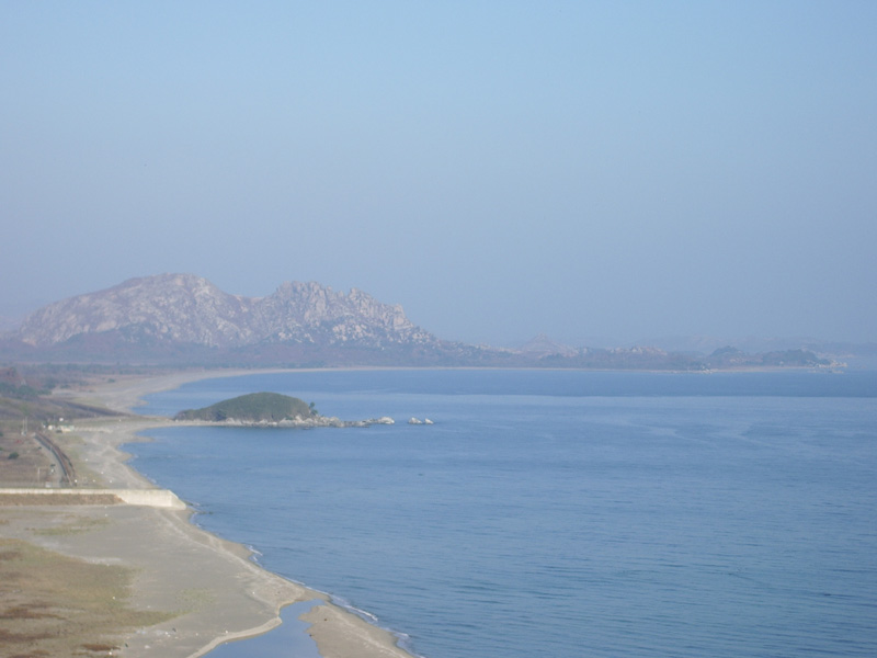
| {{Information |Description=The turtle-shaped rock in the center left is the end of South Korean jurisdiction. The peaks in the distance, and the peninsula jutting to the right, are North Korea. The area in between is the Demilitarized Zone. On the peni
|
Utilisation du fichier
La page suivante utilise ce fichier :
Usage global du fichier
Les autres wikis suivants utilisent ce fichier?:
- Utilisation sur en.wikipedia.org
- Utilisation sur ko.wikipedia.org
- Utilisation sur ms.wikipedia.org
- Utilisation sur sv.wikipedia.org
Ce fichier contient des informations supplementaires, probablement ajoutees par l'appareil photo numerique ou le numeriseur utilise pour le creer.
Si le fichier a ete modifie depuis son etat original, certains details peuvent ne pas refleter entierement l'image modifiee.
