Pandua
, also known as
Adina
, is a medieval citadel in the
Northern Plains?
of
West Bengal
, India. It is known for its massive Adina Masjid along with the ruins of a couple of mosques, tombs and darghas. A trip to Pandua can be combined with a trip to the nearby citadel of
Gour
with
Malda
as the base.
 Adina Masjid
 Panoramic view of Adina Masjid
Pandua was the first capital city of the Bengal Sultanate for 114 years, from 1339 to 1453. The capital later shifted to
Gour
. During the 13th-14th century, Bengal's rulers maintained a certain independence from the Sultans in Delhi. It was also the period of the founding of the Bengali language and the Bengali identity. The Iliyas Shah dynasty ruling from Pandua played a big role in that development. The rulers had built palaces, forts, bridges, mosques, and mausoleums, many of which are now in ruins or have disappeared completely. Whatever has survived is still enough to turn Pandua, alongside
Gour
into a leading tourism destination, but sadly the place lacks proper tourist infrastructure. Still, Gour-Pandua along with
Bishnupur
and
Murshidabad
are the three important historic tourist destinations of West Bengal.
The nearest airports are Siliguri (
IXB
IATA
) and Durgapur (
RDP
IATA
).
- 25.114397
88.12318
1
Adina
NFR
.
Only a handful of trains stop at this station. The station also lacks basic services like hotels and transport connectivity. So it is advisable to get down at Malda.

 (
updated Oct 2022
)
(
updated Oct 2022
)
Pandua is 15 km (9.3 mi) north of Malda. The normal route is to take NH 12, which links Dalkhola with Kolkata, but the longer route via Durgapur Expressway (part of NH 19) from Dankuni, NH 19 from Palsit to Panagarh bypassing
Bardhaman
city, and then taking the Panagarh-Morgram Highway up to Morgram and on to NH 12 is a more comfortable and enjoyable option.

Map of Pandua (North Bengal)
Since Pandua has no accommodation it is best explored from
Malda
. Hired cars are the best option to explore Pandua. The hotels in Malda can arrange for cars. A half-day tour is enough to explore Pandua. The tour can be clubbed with a visit to the nearby twin citadel of
Gour
, but covering Pandua and Gour in a single day may become hectic. Tourists looking out for more details need to stay at least two days in Malda, this will provide the opportunity to explore other places like Nandadirghi Vihar in Jagjibanpur, Nimasarai Minar and Old Malda Jami Masjid.
 Eklakhi Mausoleum
 Qutub Shahi Masjid
 Watch Tower
 Ruins of Hammam
 Deer Park
Covering Pandua along with
Gour
in a single day can be very hectic. People who are on a single-day trip to both can skip the deer park and environs. Pandua is a relatively much smaller site than Gour and can easily be covered in half a day.
- 25.1525
88.1645
1
Adina Masjid
.
Built in 1369 by Sultan Sikander Shah and during that time it was the largest mosque in India. The courtyard measures
507
1
⁄
2
ft (154.7 m) by
285
1
⁄
2
ft (87.0 m). The entrance is through an insignificant door. The roof had 306 domes but sadly none of them survived. The mosque contains an elevated ladies' section approached by a flight of wooden stairs. Adjacent to the mosque is a small roofless room housing the remains of Sultan Sikander Shah, the builder of the colossal mosque. The Adina Mosque contains several Hindu motifs in its structure, historians believe that they were brought from demolished Hindu temples.
- 25.132994
88.154481
2
Bari Dargah
(
Shrine of Shah Jalal Tabriz
).
(
updated Feb 2022
)
- 25.135139
88.151778
3
Choti Dargah and Selami Darwaza
(
Shrine of Alaul Haq
).
(
updated Feb 2022
)
- 25.13881
88.154294
4
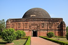
Eklakhi Mausoleum
.
Eklakhi Tomb or Mausoleum houses constructed by Sultan Jalaluddin Mohammad Shah in around 1425 at a cost of rupees one lakh (hundred thousand) and hence the name. Jalaluddin Mohammad Shah was born as Jadu, son of King Ganesh and later converted to Islam. He ruled Bengal Sultanate for 16 years. The square tomb with sides of 75 ft (23 m) is topped with a dome and houses three graves, including that of Jalaluddin Mohammad Shah. The other two graves are of his wife and son Shamsuddin Ahmed Shah. The corners are provided with minarets, whose cupolas have long collapsed. The walls of the mosque are 13 feet thick and the interior is octagonal and supports a dome of 14 ft (4.3 m) in diameter. The total height of the structure is 75 meters. The walls have rich terracotta ornamentation of decorative bricks. There are also images of Hindu gods and other human figures suggesting materials from Hindu temples were used in the construction of the tomb.
- 25.13866
88.153448
5
Qutb Shahi Masjid
(
behind the Eklakhi Mausoleum
).
Locally known as Chota Sona Masjid, the Qutb Sahi Mosque is built in honour of Saint Nur Qutb-ul-Alam. The ruins of his shrine are nearby, along with that of Saint Hazrat Shah Jalal Tabrizi, collectively known as the Bari Darga. The mosque is built in 1582. The mosque is approached through a gateway in the east. The eastern wall has five arched entrances providing access to the interiors. The northern and southern walls contain two pierced stone screens. The corners house four minarets topped with cupolas. The roof once housed ten hemispherical domes, but the domes along with the roof have long collapsed.
Deer park and environs
[
edit
]
- 25.1405
88.1727
6
Adina Deer Park
.
A well-preserved wildlife sanctuary with spotted deer and nilgais. This is controlled by the West Bengal Forest Department and one can witness migratory birds during winter. The woods are rich in butterflies and birds, especially Asian openbill, paradise flycatcher, prinia, oriole, fish eagle, etc.
(
updated Oct 2022
)
- 25.14752
88.171372
7
Hammam
,
North West corner of Deer Park
.
This hammam was once part of the royal complex of the Illiyas Shah dynasty. Nothing much remains of the royal hammam. The thick vegetation prevents access to the interiors, which once had separate chambers for hot and cold baths.
(
updated Mar 2023
)
- 25.146096
88.16716
8
Watch Tower
.
This too is located near the deer park. This minar standing on a small mound was part of the defensive system of the royal enclosure of Pandua during the Illiyas Shah dynasty. The tower served as a watch tower to keep an eye on invading armies. The base of the tower is not accessible because of overgrown vegetation. A portion of the defensive wall and the adjoining moat still stand to this day.
(
updated Mar 2023
)
There are no proper eateries in Pandua. During the tourist season, makeshift stalls sell tea and snacks along with soft drinks. Vendors also sell freshly cut seasonal fruits and ice cream. For lunch, there are a few dhabas along the highway connecting Pandua with
Malda
.
There are no accommodations in Pandua, the nearest options are in
Malda
and Gazole. Broadly speaking, there are several lodges around Tourist lodge, some around the NBSTC terminus and the private bus stand near it, and some on ABA Gani Khan Choudhury Sarani.
- Gazole Town Library
(
Gazole Sadharan Gyanagar
),
Gazole Bidrohi More
(
200 m from Gazole Bus Stand
).
(
updated Apr 2015
)
- Gour
- The twin citadel of Pandua known for its medieval ruins
- Malda
? virtually all the amenities for travellers visiting this area can be found in Malda
- Murshidabad
? about 140 km from Pandua
- Siliguri
? about 250 km from Pandua
- Kolkata
? about 347 km from Pandua