Study of the forms of land surfaces
This article is about the study of Earth's surface shape and features. For discussion of land surfaces themselves, see
Terrain
. For other uses, see
Topography (disambiguation)
.
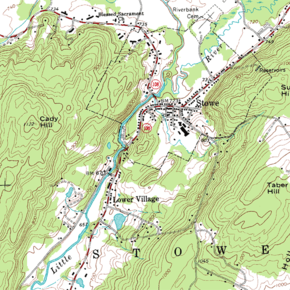 A topographic map of
Stowe, Vermont
with
contour lines
A topographic map of
Stowe, Vermont
with
contour lines
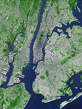 This
false-color
satellite image
illustrates topography of the
urban core
of the
New York metropolitan area
, with
Manhattan
at its center.
This
false-color
satellite image
illustrates topography of the
urban core
of the
New York metropolitan area
, with
Manhattan
at its center.
Topography
is the study of the forms and features of
land surfaces
. The topography of an area may refer to the land forms and features themselves, or a description or
depiction
in maps.
Topography is a field of
geoscience
and
planetary science
and is concerned with local detail in general, including not only
relief
, but also
natural
, artificial, and
cultural
features such as roads, land boundaries, and buildings.
[1]
In the
United States
, topography often means specifically
relief
, even though the
USGS
topographic maps
record not just
elevation
contours, but also roads, populated places, structures, land boundaries, and so on.
[2]
Topography in a narrow sense involves the recording of relief or
terrain
, the three-dimensional quality of the surface, and the identification of specific
landforms
; this is also known as
geomorphometry
. In modern usage, this involves generation of elevation data in digital form (
DEM
). It is often considered to include the graphic representation of the landform on a
map
by a variety of
cartographic relief depiction
techniques, including
contour lines
,
hypsometric tints
, and
relief shading
.
Etymology
[
edit
]
The term
topography
originated in
ancient Greece
and continued in
ancient Rome
, as the detailed description of a place. The word comes from the
Greek
τ?πο?
(
topos
, "place") and
-γραφ?α
(
-graphia
, "writing").
[3]
In classical literature this refers to writing about a place or places, what is now largely called '
local history
'. In Britain and in Europe in general, the word topography is still sometimes used in its original sense.
[4]
Detailed military surveys in
Britain
(beginning in the late eighteenth century) were called
Ordnance Surveys
, and this term was used into the 20th century as generic for topographic surveys and maps.
[5]
The earliest scientific surveys in France were the
Cassini maps
after the family who produced them over four generations.
[6]
The term "topographic surveys" appears to be American in origin. The earliest detailed surveys in the United States were made by the "Topographical Bureau of the Army", formed during the
War of 1812
,
[7]
which became the
Corps of Topographical Engineers
in 1838.
[8]
After the work of national mapping was assumed by the
U.S. Geological Survey
in 1878, the term topographical remained as a general term for detailed surveys and mapping programs, and has been adopted by most other nations as standard.
In the 20th century, the term topography started to be used to describe surface description in other fields where
mapping
in a broader sense is used, particularly in medical fields such as
neurology
.
Objectives
[
edit
]
An objective of topography is to determine the position of any feature or more generally any point in terms of both a horizontal
coordinate system
such as latitude, longitude, and
altitude
. Identifying (naming) features, and recognizing typical landform patterns are also part of the field.
A
topographic study
may be made for a variety of reasons: military planning and geological exploration have been primary motivators to start survey programs, but detailed information about
terrain
and surface features is essential for the
planning
and
construction
of any major
civil engineering
,
public works
, or
reclamation
projects.
Techniques
[
edit
]
There are a variety of approaches to studying topography. Which method(s) to use depends on the scale and size of the area under study, its accessibility, and the quality of existing surveys.
Field survey
[
edit
]
 A surveying point in
Germany
A surveying point in
Germany
Surveying helps determine accurately the terrestrial or
three-dimensional space
position of points and the distances and
angles
between them using
leveling instruments
such as
theodolites
,
dumpy levels
and
clinometers
.
GPS
and other
global navigation satellite systems
(GNSS) are also used.
Work on one of the first topographic maps was begun in France by
Giovanni Domenico Cassini
, the great Italian astronomer.
Even though remote sensing has greatly sped up the process of gathering information, and has allowed greater accuracy control over long distances, the direct survey still provides the basic control points and framework for all topographic work, whether manual or
GIS
-based.
In areas where there has been an extensive direct survey and mapping program (most of Europe and the Continental U.S., for example), the compiled data forms the basis of basic digital elevation datasets such as
USGS DEM
data. This data must often be "cleaned" to eliminate discrepancies between surveys, but it still forms a valuable set of information for large-scale analysis.
The original American
topographic surveys
(or the British "Ordnance" surveys) involved not only recording of relief, but identification of landmark features and vegetative land cover.
Remote sensing
[
edit
]
Remote sensing
is a general term for geodata collection at a distance from the subject area.
Passive sensor methodologies
[
edit
]
Besides their role in photogrammetry, aerial and satellite imagery can be used to identify and delineate terrain features and more general land-cover features. Certainly they have become more and more a part of
geovisualization
, whether
maps
or
GIS
systems. False-color and non-visible
spectra
imaging can also help determine the lie of the land by delineating vegetation and other land-use information more clearly. Images can be in visible colours and in other spectrum.
Photogrammetry
[
edit
]
Photogrammetry is a measurement technique for which the
co-ordinates
of the points in
3D
of an object are determined by the measurements made in two
photographic
images (or more) taken starting from different positions, usually from different passes of an aerial photography flight. In this technique, the common points are identified on each
image
. A line of sight (or
ray
) can be built from the camera location to the point on the object. It is the intersection of its rays (
triangulation
) which determines the relative three-dimensional position of the point. Known control points can be used to give these relative positions absolute values. More sophisticated
algorithms
can exploit other information on the scene known a priori (for example, symmetries in certain cases allowing the rebuilding of three-dimensional co-ordinates starting from one only position of the camera).
Active sensor methodologies
[
edit
]
Satellite
RADAR
mapping is one of the major techniques of generating Digital Elevation Models (see below). Similar techniques are applied in
bathymetric
surveys using
sonar
to determine the terrain of the ocean floor. In recent years,
LIDAR
(
LI
ght
D
etection
A
nd
R
anging), a remote sensing technique that uses a laser instead of radio waves, has increasingly been employed for complex mapping needs such as charting canopies and monitoring glaciers.
Forms of topographic data
[
edit
]
Terrain is commonly modelled either using vector (
triangulated irregular network
or TIN) or gridded (
raster image
) mathematical models. In the most applications in
environmental sciences
, land surface is represented and modelled using gridded models. In civil engineering and entertainment businesses, the most representations of land surface employ some variant of TIN models. In
geostatistics
, land surface is commonly modelled as a combination of the two signals ? the smooth (spatially correlated) and the rough (noise) signal.
In practice, surveyors first sample heights in an area, then use these to produce a Digital Land Surface Model in the form of a
TIN
. The DLSM can then be used to visualize terrain, drape remote sensing images, quantify ecological properties of a surface or extract land surface objects. The contour data or any other sampled elevation datasets are not a DLSM. A DLSM implies that elevation is available continuously at each location in the study area, i.e. that the map represents a complete surface. Digital Land Surface Models should not be confused with Digital Surface Models, which can be surfaces of the canopy, buildings and similar objects. For example, in the case of surface models produces using the lidar technology, one can have several surfaces ? starting from the top of the canopy to the actual solid earth. The difference between the two surface models can then be used to derive volumetric measures (height of trees etc.).
Raw survey data
[
edit
]
Topographic survey information is historically based upon the notes of surveyors. They may derive naming and cultural information from other local sources (for example,
boundary
delineation may be derived from local
cadastral
mapping). While of historical interest, these field notes inherently include errors and contradictions that later stages in map production resolve.
Remote sensing data
[
edit
]
As with field notes, remote sensing data (aerial and satellite photography, for example), is raw and uninterpreted. It may contain holes (due to cloud cover for example) or inconsistencies (due to the timing of specific image captures). Most modern topographic mapping includes a large component of remotely sensed data in its compilation process.
Topographic mapping
[
edit
]
 A map of
Europe
using
elevation modeling
A map of
Europe
using
elevation modeling
In its contemporary definition, topographic mapping shows relief. In the United States,
USGS
topographic maps show relief using
contour lines
. The USGS calls maps based on topographic surveys, but without contours, "planimetric maps."
These maps show not only the contours, but also any significant streams or other bodies of water,
forest cover
, built-up areas or individual buildings (depending on scale), and other features and points of interest.
While not officially "topographic" maps, the national surveys of other nations share many of the same features, and so they are often called "topographic maps."
Existing topographic survey maps, because of their comprehensive and encyclopedic coverage, form the basis for much derived topographic work. Digital Elevation Models, for example, have often been created not from new remote sensing data but from existing paper topographic maps. Many government and private publishers use the artwork (especially the contour lines) from existing topographic map sheets as the basis for their own specialized or updated topographic maps.
[9]
Topographic mapping should not be confused with
geologic mapping
. The latter is concerned with underlying structures and processes to the surface, rather than with identifiable surface features.
Digital elevation modeling
[
edit
]
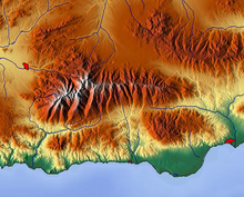 Relief map:
Sierra Nevada Mountains
,
Spain
Relief map:
Sierra Nevada Mountains
,
Spain
 3D rendering of a
DEM
used for the
topography of Mars
3D rendering of a
DEM
used for the
topography of Mars
The digital elevation model (DEM) is a
raster
-based
digital
dataset of the topography (
hypsometry
and/or
bathymetry
) of all or part of the Earth (or a
telluric planet
). The
pixels
of the dataset are each assigned an elevation value, and a header portion of the dataset defines the area of coverage, the units each pixel covers, and the units of elevation (and the zero-point). DEMs may be derived from existing paper maps and survey data, or they may be generated from new satellite or other remotely sensed
radar
or
sonar
data.
Topological modeling
[
edit
]
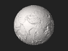 STL 3D model
of Earth without liquid water with 20× elevation exaggeration
STL 3D model
of Earth without liquid water with 20× elevation exaggeration
A
geographic information system
(GIS) can recognize and analyze the spatial relationships that exist within digitally stored spatial data. These topological relationships allow complex spatial
modelling
and analysis to be performed. Topological relationships between geometric entities traditionally include adjacency (what adjoins what), containment (what encloses what), and proximity (how close something is to something else).
- reconstitute a sight in synthesized images of the ground,
- determine a trajectory of overflight of the ground,
- calculate surfaces or volumes,
- trace topographic profiles,
Topography in other fields
[
edit
]
Topography has been applied to different science fields. In
neuroscience
, the
neuroimaging
discipline uses techniques such as EEG topography for
brain mapping
. In
ophthalmology
,
corneal topography
is used as a technique for mapping the surface curvature of the
cornea
. In
tissue engineering
,
atomic force microscopy
is used to map
nanotopography
.
In
human anatomy
, topography is
superficial human anatomy
.
In mathematics the concept of topography is used to indicate the patterns or general organization of features on a map or as a term referring to the pattern in which variables (or their values) are distributed in a space.
Topographers
[
edit
]
Topographers
are experts in topography. They study and describe the surface features of a place or region.
See also
[
edit
]
References
[
edit
]