한국   대만   중국   일본 
Yokohama Bay Bridge - Wikipedia Jump to content

Yokohama Bay Bridge

Coordinates : 35°27′18″N 139°40′27″E  /  35.4551°N 139.6742°E  / 35.4551; 139.6742
From Wikipedia, the free encyclopedia
Yokohama Bay Bridge
Coordinates 35°27′18″N 139°40′27″E  /  35.4551°N 139.6742°E  / 35.4551; 139.6742
Carries 3 lanes of Bayshore Route (upper), 1 lane of National Route 357 (lower), prohibited to pedestrians or bicycles
Crosses Port of Yokohama
Locale between Honmoku and Daikoku Pier, Naka-ku, Yokohama , Kanagawa
Characteristics
Design Cable-stayed
Total length 860 metres (2,820 ft) [1]
Width 40.2 metres (132 ft)
Height 172 metres (564 ft)
Longest span 460 m (1,509.2 ft) [1]
Clearance above Higher truck loads possible
Clearance below 55 metres (180 ft)
History
Opened September 27, 1989
Location
Map
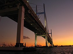
Yokohama Bay Bridge at dawn

The Yokohama Bay Bridge ( ?浜ベイブリッジ , Yokohama Bei Buridji ) is an 860 metres (2,820 ft) cable stayed bridge in Yokohama, Japan . Opened September 27, 1989, it crosses Tokyo Bay with a span of 460 metres (1,510 feet). The toll is 600. The bridge is part of the Bayshore Route of the Shuto Expressway .

Notes [ edit ]

  1. ^ a b "Yokohama Bay Bridge" . Ministry of Land, Infrastructure, Transportation and Tourism (MLIT) . Retrieved 2010-07-10 .

External links [ edit ]