WikiProject Pakistan's
cartography
page is aimed at gathering well made high-quality images of maps and topographical and demographical data displayed on maps.
This project aims to draw hi-resolution, vector maps (most preferably
.SVG
or .SVGZ) for articles relating to Pakistan or otherwise to territories that fall within the geographical boundaries of the nation. It also aims to get hi-resolution raster (
.PNG
) images for
topographical
and demographical images on a map. Another aim is to reproduce the maps previously created by Pakistani Wikipedians to employ the benefits of vector graphics and the
suggested colours
.
The scope of the project
[
edit
]
The scope of the project is related but certainly not limited to the following:
- NPOV
maps related to Pakistan or any other south-Asian nation (post 1947)
- Pre-Independence south Asian sub-continental
cartography
- The nations targeted may include
India
,
PRC
,
Bangladesh
,
Sri Lanka
,
Nepal
,
Bhutan
,
Iran
,
Afghanistan
- It is encouraged that a
Neutral Point of View
be taken into consideration while submitting maps relating to the disputed territories of
Kashmir
.
Sister projects
[
edit
]
- WP India's cartography page
It is advised that images that may be a part of the Indian territorial cartography be also made available to the sister cartography page at
WP India
.
You can participate by adding your name in the list below. Alternatively you can nominate a fellow Wikipedian whom you know has created a map for a Pakistan-related article to this list.
- Arunreginald
?(
talk
·
contribs
)
- Pahari?Sahib
?(
talk
·
contribs
) ? nominated by
Arunreginald
?(
talk
·
contribs
)
- Abbasi786786
?(
talk
·
contribs
)
The project is divided into locator maps, general maps and city maps.
Locator
[
edit
]
Locator maps are used to show the location of a city, town, state or particular area within India. It is also used to show the location of a district, division or region in a map of a state.
General maps
[
edit
]
Non-locator maps. Maps of this type include rivers, ancient kingdoms, crop-related etc.
City maps
[
edit
]
 Example of a city map
Maps of cities. See the featured image of
Manila
alongside for reference. You can take example from the
Image:Sindh Hyderabad Saddar city map.svg
that was created to duplicate the mapping technologies used in the former image.
Topographical maps
[
edit
]
These maps depict the topography of a region. See
User:Captain Blood/GMT Example
for an example.
Cartography conventions are best practices collected from the
WikiProject Maps talk page
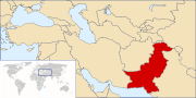
. Following the mentioned conventions, all maps currently available on the Wikipedia for Pakistan-related articles should be converted into SVG or PNG format. A very good exemplar is the map for the location of Pakistan (pictured left). Please report Pakistan-related maps that do not follow the mentioned guidelines and
request
an update if no one else has. Your help would be appreciated.
Colours
[
edit
]
It is recommended by cartographers on Wikipedia that the following colours be used when creating maps. Adhering to these standards may well render the maps created suitable for use in other major Wikipedia articles. You can further debate in the
discussion
for this project.
Convention for locator maps (
2012 scheme
) (
see more
).
| Subject
|
Colorimetry
(RGB/hex)
|
| Landmasses
|
| Toponymes (names)
|
|
| Territory of interest / Marked / Focus
|
|
| Surrounding territories (Internal).
|
#FDFBEA
R:253 G:251 B:234
|
| Surrounding landmass (Outside)
|
#DFDFDF
R:223 G:223 B:223
|
| Background D (opacity 50%)
|
|
| Foreground C (opacity 50%)
|
|
| Circle marker opacity, glow effect, zoom box: scale effect (opacity 25%)
|
|
Political borders. Country, state, and province borders.
Nuance is provided by line styling.
|
#656565
R:101 G:101 B:101
|
| Water.
|
| Hydronymes (names).
|
|
| Rivers; coastlines for lakes, oceans.
|
|
| Water bodies: oceans, seas or lakes.
|
#C7E7FB
R:199 G:231 B:251
|
| Helper
|
| Zoom box shadow (opacity 50%)
|
|
|
Naming (upload):
- File:
{Subject name in English} locator map (blank).svg
(for template map)
- File:
{Subject name in English} locator map-en.svg
for English version
- File:
{Subject name in English} locator map-ko.svg
for Korean version
- File:
{Subject name in English} locator map-num.svg
for numbered international version
|
Convention for Area maps (
see more
).
| Subject
|
Colorimetry
(RGB/hex)
|
| Point of interest (cities especially).
|
|
| Area of interest (species range, etc).
|
#F07568
R:240 G:117 B:104
|
| Border colour for areas of interest.
|
|
| Parks or natural preservation areas.
|
#A0F090
R:160 G:240 B:144
|
| Maps with opposite groups
[1]
|
| Color n?1, opacity 100 or 40%:
|
|
| Color n?2, opacity 100 or 40%:
|
|
| Color n?3, opacity 100 or 40%:
|
|
| Color n?4, opacity 100 or 40%:
|
|
| Color n?5, opacity 100 or 40% (/!\ may conflict with water bodies):
|
|
| Color n?6, opacity 100 or 40%:
|
|
| Color n?7, opacity 100 or 40%:
|
|
| Color for bird distribution map
|
| Year-round.
|
#adafd8
R:173 G:175 B:216
|
| Breeding areas.
|
#f5ae8c
R:245 G:174 B:140
|
| Migration or migratory areas.
|
#f7e983
R:247 G:233 B:131
|
| Non-breeding areas.
|
#9dcce9
R:157 G:204 B:233
|
| Introduced areas.
|
|
|
Naming (upload):
- File:
{Subject name in English} locator map.svg
(or png, for locator maps)
- File:
{Subject name in English} map.svg
(or png)
For species, use the binominal name. For others, use the English wiki article title. If needed, add just after the subject name the section's name, the year, etc.
Note:
- Colours
: A maximum of four colours is required for complex multi-color area maps (see
Four color theorem
).
|
You can request maps that need tinkering. Requests can be made for maps not available or for updates to maps that do not follow the below mentioned cartography conventions.
To request a map for a Pakistan-related article where the map is not available, use the following template in your Wiki text. Using this template would list the request in a category for Pakistan-related map requests.
{{reqmapin|Pakistan}}
If you think that the map request may be relative to an Indian article (or any other nation's) as well, then add the other nation's name beside the request as depicted below.
{{reqmapin|Pakistan|India}}
Locator Map Requests
[
edit
]
Locator maps are used to show the location of a city, town, state or particular area within Pakistan. It is also used to show the location of a district, division or region in a map of a province. Following are locator maps requested for various regions of Pakistan.
 Mercator Map (1578) - Asiae-Tabula IX