Narrow strip of land in northeastern Afghanistan
The
Wakhan Corridor
(
Pashto
:
????? ?????
,
romanized:
Vaxan dahlez
;
Persian
:
????? ?????
,
romanized
:
dalan-e vaxan
) is a
narrow strip of territory
located within the
Badakhshan province
of
Afghanistan
. This corridor stretches eastward, connecting Afghanistan to
Xinjiang
, China. It also separates the
Gorno-Badakhshan Autonomous Region
of Tajikistan in the north from the
Gilgit-Baltistan
region of
Kashmir
(which is disputed by
India
and
Pakistan
) in the south.
[1]
[2]
[3]
[4]
[5]
[a]
This high mountain valley serves as the source of both the
Panj
and
Pamir
rivers, which converge to form the larger
Amu River
. For countless centuries, a vital trade route has traversed this valley, facilitating the movement of travelers to and from East, South, and Central Asia.
[6]
The corridor was formed after an 1893 agreement between
Mortimer Durand
of the
British Raj
and
Emir
Abdur Rahman Khan
of Afghanistan, creating the
Durand Line
.
[7]
This narrow strip acted as a
buffer zone
between the
Russian Empire
and the British Empire (the regions of
Russian Turkestan
, now in Tajikistan and the northern part of British Raj, now in Pakistan). Its eastern end bordered China's Xinjiang region, then claimed by the
Qing dynasty
.
The corridor is in the
Wakhan District
of Afghanistan's Badakhshan province. As of 2020, it had 17,167 residents.
[8]
The northern part of the Wakhan, populated by the
Wakhi
and
Pamiri
people, is also referred to as the
Pamir
. The closest major airport for the residents to use is
Fayzabad Airport
in the city of
Fayzabad
to the west, which can be reached by a road network.
Geography
[
edit
]
 Floodplains
in the Wakhan Corridor
Floodplains
in the Wakhan Corridor
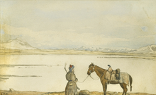 Lake Victoria
, the
Great Pamir
, 2 May 1874
, watercolour by
Thomas Edward Gordon
[9]
Lake Victoria
, the
Great Pamir
, 2 May 1874
, watercolour by
Thomas Edward Gordon
[9]
At its western entrance, near the Afghan town of
Ishkashim
, the corridor is 18 km (11 mi) wide.
[4]
The western third of the corridor varies in width (13?30 km (8?19 mi)) and widens to 65 km (40 mi) in the central Wakhan.
[4]
At its eastern end, the corridor forks into two prongs that wrap around a salient of Chinese territory, forming the 92 km (57 mi) boundary between the two countries.
[4]
The
Wakhjir Pass
, which is the easternmost point on the southeastern prong, is about 300 km (190 mi) from Ishkashim.
[4]
The easternmost point of the northeastern prong is a nameless wilderness about 350 km (220 mi) from Ishkashim.
[4]
On the Chinese side of the border is the
Tashkurgan Tajik Autonomous County
of
Xinjiang Uyghur Autonomous Region
.
The northern border of the corridor is formed by the
Pamir River
and Lake
Zorkul
in the west and the high peaks of the Pamir Mountains in the east. To the north is Tajikistan's Gorno-Badakhshan Autonomous
Region
. To the south, the corridor is bounded by the high mountains of the
Hindu Kush
and
Karakoram
. Along the southern flank of the corridor, there are two mountain passes that connect the corridor to its neighbours. The
Broghol
pass offers access to the
Khyber Pakhtunkhwa
region of Pakistan, while the
Irshad Pass
connects the corridor to Gilgit-Baltistan. The Dilisang Pass, which also connects to Gilgit-Baltistan, is disused.
[10]
The easternmost pass, as indicated above, is the
Wakhjir Pass
, which connects to China and is the only border connection between that country and Afghanistan.
The corridor is higher in the east than in the west; (the Wakhjir Pass is 4,923 m (16,152 ft) in elevation) and descends to about 3,037 m (9,964 ft) at Ishkashim.
[11]
The Wakhjir River emerges from an ice cave on the Afghan side of the Wakhjir Pass and flows west, joining the Bozai Darya near the village of
Bozai Gumbaz
to form the
Wakhan River
. The Wakhan River then joins the Pamir River near
Kala-i-Panj
to form the
Panj River
, which then flows out of the Wakhan Corridor at Ishkashim.
The Chinese consider
Chalachigu Valley
, the valley east of Wakhjir Pass on the Chinese side connecting
Taghdumbash Pamir
, to be part of the Wakhan Corridor. The high mountain valley is about 100 km (60 mi) long. This valley, through which the Tashkurgan River flows, is generally about 3?5 km (2?3 mi) wide and less than 1 km (0.6 mi) at its narrowest point.
[12]
This entire valley on the Chinese side is closed to visitors; however, local residents and herders from the area are permitted access.
[13]
History
[
edit
]
Although the terrain is extremely rugged, the Corridor was historically used as a trading route between
Badakhshan
and
Yarkand
.
[14]
It appears that
Marco Polo
came this way.
[15]
The Portuguese Jesuit priest
Bento de Goes
crossed from the Wakhan to China between 1602 and 1606. In May 1906,
Sir Aurel Stein
explored the Wakhan and reported that at that time, 100 pony loads of goods crossed annually to China.
[16]
There were further crossings in 1874 by Captain
T.E. Gordon
of the British Army,
[17]
in 1891 by
Francis Younghusband
,
[18]
and in 1894 by
Lord Curzon
.
[19]
Early travellers used one of three routes:
- A northern route led up the valley of the Pamir River to Zorkul Lake, then east through the mountains to the valley of the
Bartang River
, then across the
Sarikol Range
to
China
.
- A southern route led up the valley of the Wakhan River to the Wakhjir Pass to China. This pass is closed for at least five months a year and is only open irregularly for the remainder.
[20]
- A central route branched off the southern route through the
Little Pamir
to the Murghab River valley.
From a non-Afghan point of view, the corridor is in part a political creation from
The Great Game
between British India and Russian Empire. In the north, an agreement between the empires in 1873 effectively split the historic region of
Wakhan
by making the Panj and Pamir Rivers the border between Afghanistan and the then-Russian Empire.
[4]
In the south, the
Durand Line Agreement
of 1893 marked the boundary between British India and Afghanistan. This left a narrow strip of land ruled by Afghanistan as a buffer between the two empires, which became known as the Wakhan Corridor in the 20th century.
[21]
The corridor has been closed to regular traffic for over a century
[11]
and there is no modern road. There is a rough road from
Ishkashim
to
Sarhad-e Broghil
[22]
built in the 1960s,
[23]
but only rough paths beyond. These paths run some 100 km (60 mi) from the road end to the Chinese border at Wakhjir Pass, and further to the far end of the Little Pamir.
Jacob Townsend has speculated on the possibility of
drug smuggling
from Afghanistan to China via the Wakhan Corridor and Wakhjir Pass, but concluded that due to the difficulties of travel and border crossings, it would be minor compared to that conducted via Tajikistan's
Gorno-Badakhshan Autonomous Province
or through Pakistan, both having much more accessible routes into China.
[24]
The remoteness of the region has meant that, despite the long-running
wars of Afghanistan
since the late 1970s, the region has remained virtually untouched by conflict, and many locals, mostly composed of ethnic
Pamir
and
Kyrgyz
, are not aware of the wars in the country.
[25]
The
Islamic Republic of Afghanistan
asked the
People's Republic of China
on several occasions to open the border in the Wakhan Corridor for economic reasons or as an alternative supply route for fighting the
Taliban insurgency
. The Chinese resisted, largely due to
unrest
in its far western province of Xinjiang, which borders the corridor.
[26]
[27]
In December 2009
[update]
, it was reported that the United States had asked China to open the corridor.
[28]
In July, 2021, the area came under the
Taliban
control for the first time during the group's
summer offensive
.
[29]
It was reported that hundreds of ethnic Kyrgyz nomads along with their livestock attempted to flee north into Tajikistan.
[30]
It is patrolled by forces of the
Islamic Emirate of Afghanistan
, which took over responsibility from the previous
NATO
-trained
Afghan National Security Forces
.
[31]
[32]
As of June 2023, there had been discussions between foreign ministers of China and Afghanistan to the opening of the strategically significant corridor to enhance the trade ties between
Beijing
and
Kabul
. Afghanistan's Foreign Minister
Amir Khan Muttaqi
and Chinese Foreign Minister
Wang Yi
both met on the sidelines in Tibet during the third Trans-Himalaya Forum for International Cooperation, to discuss the possibilities of improving trade ties.
[33]
See also
[
edit
]
References
[
edit
]
- Citations
- ^
Bruce Elleman; Stephen Kotkin; Clive Schofield (18 May 2015).
Beijing's Power and China's Borders: Twenty Neighbors in Asia
. M.E. Sharpe. pp. 13?.
ISBN
978-0-7656-2766-7
.
The Sino-Afghan border was delimited in a secret treaty signed during November 1963. The corridor shares a border with Pakistan to its south and Tajikistan to its north.
- ^
Pervaiz I Cheema; Manuel Riemer (22 August 1990).
Pakistan's Defence Policy 1947-58
. Palgrave Macmillan UK. pp. 46?.
ISBN
978-1-349-20942-2
.
In addition, the Soviet Union is separated from Pakistani territory by a small strip commonly known as the Wakhan corridor. Theoretically the Soviet Union does not have a common border with Pakistan but in view of their close linkage with Afghanistan and the shortness of Wakhan's breadth make it an immediate neighbour for all practical purposes.
- ^
Yasmeen Niaz Mohiuddin (2007).
Pakistan: A Global Studies Handbook
. ABC-CLIO. pp. 18?.
ISBN
978-1-85109-801-9
.
The Chitral and Kalash valleys of the Hindu Kush Mountains are located north of the Swat Valley in the Chitral district of the North-West Frontier Province and are bordered by Afghanistan on the north, south, and west. The Wakhan Corridor separates Pakistan from Tajikistan. The corridor, wedged between the
Pamir Mountains
to the north and the
Karakoram
range to the south, is about 350 km (220 mi) long and 13?65 kilometres (8?40 mi) wide.
- ^
a
b
c
d
e
f
g
International Boundary Study of the Afghanistan?USSR Boundary (1983)
by the US
Bureau of Intelligence and Research
Pg. 7.
Archived
on 2011-06-07
- ^
Ashraf, Fahmida (1986).
"The Strategic Wakhan"
.
Strategic Studies
.
9
(2): 48?67.
ISSN
1029-0990
.
JSTOR
45182417
.
Archived
from the original on 5 April 2023
. Retrieved
4 April
2023
.
- ^
"Wakhan Corridor travel guide"
.
Caravanistan
. Retrieved
29 October
2018
.
- ^
Nystrop, Richard F. And Donald M. Seekins, eds. Afghanistan a Country Study. Washington: Library of Congress, 1986, p. 38.
- ^
https://web.archive.org/web/20210624204559/https://www.nsia.gov.af:8080/wp-content/uploads/2021/06/Estimated-Population-of-Afghanistan1-1400.pdf
(p. 87)
- ^
"Lake Victoria, Great Pamir, May 2nd, 1874 - Lake Victoria, Great Pamir, May 2nd, 1874"
.
Sphinxfineart.com
. Retrieved
11 December
2021
.
- ^
The pass was crossed by a couple in 1950 and by a couple in 2004. See
J.Mock and K. O'Neil: Expedition Report
Archived
8 January 2011 at the
Wayback Machine
- ^
a
b
FACTBOX-Key facts about the Wakhan Corridor
Archived
25 January 2022 at the
Wayback Machine
.
Reuters
. 12 June 2009
- ^
"新疆?境行:?者抵?瓦罕走廊中方最西端(?)_新?中心_新浪?"
[Xinjiang Border Tour: Reporter arrived at the Chinese westernmost point of Wakhan Corridor].
news.sina.com.cn
(in Chinese).
Global Times
. 7 July 2011.
Archived
from the original on 18 August 2016
. Retrieved
5 February
2017
.
- ^
Urwin, Simon (3 July 2021).
"A new road to an inaccessible land"
.
BBC Travel
. Retrieved
14 November
2021
.
- ^
Stein, Mark Aurel
(1907).
"Ancient Khotan"
.
Nature
.
76
(1981): 619?620.
Bibcode
:
1907Natur..76..619H
.
doi
:
10.1038/076619a0
.
S2CID
3999325
.
- ^
The Travels of Marco Polo
, Book 1, Chapter 32
- ^
Shahrani, M. Nazif (1979 and 2002) p.37
- ^
Keay, J. (1983).
When Men and Mountains Meet
. pp. 256?7.
ISBN
0-7126-0196-1
.
- ^
Younghusband, F. (1896, republished 2000) "The Heart of a Continent"
ISBN
978-1-4212-6551-3
- ^
"Geographical Journal" (July to September 1896)
- ^
Townsend, Jacob (2005). "4. Routes into Xinjiang".
China and Afghan Opiates: Assessing the Risk
(PDF)
. Archived from
the original
(PDF)
on 17 July 2012.
- ^
Jacobs, Frank (5 December 2011).
"A Few Salient Points"
.
The New York Times
.
Archived
from the original on 2 July 2018
. Retrieved
19 May
2017
.
- ^
"2004 Mock & O'Neil Wakhan Expedition Report"
.
Mockandoneil.com
.
Archived
from the original on 9 May 2013
. Retrieved
11 December
2021
.
- ^
"United Nations Environment Programme (2003)
Wakhan Mission Report
"
(PDF)
.
Archived
(PDF)
from the original on 16 August 2019
. Retrieved
26 July
2010
.
- ^
"China and Afghan Opiates: Assessing the Risk"
(Chapter 4). June 2005
- ^
"Wakhan Corridor: The Afghanistan Province Untouched by Government, War or Terror"
. 10 February 2018.
- ^
Afghanistan tells China to open Wakhan corridor route
.
The Hindu
. 11 June 2009
Archived
8 January 2011 at the
Wayback Machine
- ^
China mulls Afghan border request
Archived
10 September 2017 at the
Wayback Machine
. BBC News Online. 12 June 2009
- ^
"Southasiaanalysis.org"
.
Southasiaanalysis.org
. Archived from
the original
on 13 June 2010
. Retrieved
11 December
2021
.
- ^
Juanola, Marta Pascual (23 July 2021).
"The Taliban conquest of a thin strip of land could change Afghanistan"
.
The Sydney Morning Herald
.
Archived
from the original on 27 August 2021
. Retrieved
11 December
2021
.
- ^
Kramer, Andrew E. (29 July 2021).
"These Herders Lived in Peaceful Isolation. Now, War Has Found Them"
.
The New York Times
.
Archived
from the original on 29 July 2021
. Retrieved
11 December
2021
.
- ^
"Cabinet orders military deployment, services in Wakhan valley"
.
Pajhwok Afghan News
. 20 November 2022
. Retrieved
21 December
2022
.
- ^
"Wakhan: The Corridor of Complication between Taliban, Pakistan and China"
.
India Today
. 1 August 2022
. Retrieved
21 December
2022
.
- ^
"Chinese, Afghan foreign ministers discuss opening of strategic Wakhan Corridor"
.
www.aa.com.tr
. Retrieved
24 October
2023
.
- Sources
External links
[
edit
]
|
|---|
|
| Districts
| | |
|---|
Populated
places
| |
|---|
Buildings and
structures
| |
|---|
| Other
| |
|---|
|
37°N
73°E
/
37°N 73°E
/
37; 73