River in South America
| Uruguay River
|
|---|
 Sunset in the Uruguay River, from
Misiones
, Argentina
|
 Map of the Uruguay River
|
| Native name
| |
|---|
|
| Countries
| |
|---|
|
|
| Source
| Pelotas River
|
|---|
| • location
| Serra Geral
,
Brazil
|
|---|
| • elevation
| 1,800 m (5,900 ft)
|
|---|
|
|
|
| 2nd source
| Canoas River
|
|---|
| • location
| Serra Geral
,
Brazil
|
|---|
|
|
| Mouth
| Rio de la Plata
|
|---|
• location
| Argentina
,
Uruguay
|
|---|
• coordinates
| 34°12′S
58°18′W
/
34.200°S 58.300°W
/
-34.200; -58.300
[1]
|
|---|
• elevation
| 0 m (0 ft)
|
|---|
| Length
| 1,838 km (1,142 mi)
[2]
|
|---|
| Basin size
| 353,451 km
2
(136,468 sq mi)
[3]
365,000 km
2
(141,000 sq mi)
[4]
|
|---|
|
| Discharge
|
|
|---|
| • location
| Rio de La Plata
(near mouth)
|
|---|
| • average
| (Period 1971?2010)7,058 m
3
/s (249,300 cu ft/s)
[5]
(Period: 1971?2000)7,558.3 m
3
/s (266,920 cu ft/s)
[6]
5,500 m
3
/s (190,000 cu ft/s)
[4]
217 km
3
/a (6,900 m
3
/s)
[7]
7,220 m
3
/s (228 km
3
/a)
[8]
|
|---|
|
|
|
| Discharge
|
|
|---|
| • location
| Concordia
,
Salto Grande
(Basin size 243,404 km
2
(93,979 sq mi)
|
|---|
| • average
| (Period 1971?2010)5,725 m
3
/s (202,200 cu ft/s)
[5]
4,622 m
3
/s (163,200 cu ft/s)
|
|---|
|
|
|
| Discharge
|
|
|---|
| • location
| Paso de los Libres
(Basin size 191,242 km
2
(73,839 sq mi)
|
|---|
| • average
| (Period 1971?2010)4,789 m
3
/s (169,100 cu ft/s)
[5]
|
|---|
|
|
|
| Discharge
|
|
|---|
| • location
| El Soberbio
(Basin size 83,949 km
2
(32,413 sq mi)
|
|---|
| • average
| (Period 1971?2010)2,384 m
3
/s (84,200 cu ft/s)
[5]
|
|---|
|
|
|
| Progression
| Rio de la Plata
→
Atlantic Ocean
|
|---|
| River system
| Rio de la Plata
|
|---|
| Tributaries
|
|
|---|
| • left
| Rio Negro
,
Ibicui
,
Pelotas
|
|---|
| • right
| Gualeguaychu
,
Canoas
|
|---|
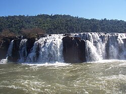 The Mocona Falls (also known as the Yucuma Falls), where the river passes between
Argentina
and
Brazil
, are up to 3 km wide
The Mocona Falls (also known as the Yucuma Falls), where the river passes between
Argentina
and
Brazil
, are up to 3 km wide
 Map of the
Rio de la Plata Basin
, showing the Uruguay River joining the Parana near
Buenos Aires
Map of the
Rio de la Plata Basin
, showing the Uruguay River joining the Parana near
Buenos Aires
The
Uruguay River
(
Spanish
:
Rio Uruguay
[?ri.o
w?u??waj]
;
Portuguese
:
Rio Uruguai
[??i.u
u?u??waj]
) is a major
river
in
South America
. It flows from north to south and forms parts of the boundaries of
Brazil
,
Argentina
and
Uruguay
, separating some of the Argentine provinces of
La Mesopotamia
from the other two countries. It passes between the states of
Santa Catarina
and
Rio Grande do Sul
in Brazil; forms the eastern border of the provinces of
Misiones
,
Corrientes
and
Entre Rios
in Argentina; and makes up the western borders of the departments of
Artigas
,
Salto
,
Paysandu
,
Rio Negro
,
Soriano
and
Colonia
in Uruguay.
Etymology
[
edit
]
The name of the river tends to comes from the Spanish settlers' interpretation of the
Guarani language
word the inhabitants of the region used to designate it. There are several interpretations, including "the river of the
uru
(an indigenous bird)", and "[river of] the urugua" (an indigenous
gastropod
,
Pomella
megastoma
).
[9]
Course
[
edit
]
The river measures about 1,838 kilometres (1,142 mi) in length and starts in the
Serra do Mar
in
Brazil
,
[10]
[11]
[12]
[13]
[14]
where the
Canoas River
and the
Pelotas River
are joined, at about 200 metres (660 ft)
above mean sea level
. At this stage, the river goes through uneven, broken terrain, forming
rapids
and falls. Its course through
Rio Grande do Sul
is not navigable.
An unusual feature of the Uruguay River is a
submerged
canyon
. This canyon formed during
the Ice Age
, when the climate was drier and the river was narrower. Its depth is up to 100 metres (330 ft) below the bottom of the river channel and it is 1/8 to 1/3 as wide as the river.
[13]
[15]
The canyon is only visible in two places, one of which is the Mocona Falls (also called the Yucuma Falls). However, the falls are not visible for 150 days per year and become more like rapids when they are not visible. Unlike most
waterfalls
, the Mocona Falls are
parallel
to the river, not
perpendicular
. The falls are 10 metres (33 ft) to 12 metres (39 ft) high and between 1,800 metres (5,900 ft) and 3,000 metres (9,800 ft) wide. They are 1,215 kilometres (755 mi) from the mouth of the river.
[13]
[15]
The 17,491 hectares (43,220 acres)
Turvo State Park
, created in 1947, protects the Brazilian side of the falls.
[16]
Together with the
Parana River
, the Uruguay forms the
Rio de la Plata
estuary
. It is navigable from around
Salto Chico
. Its main
tributary
is the
Rio Negro
, which is born in the south of Brazil and goes through Uruguay for 500 km until its
confluence
with the Uruguay River, which is located 100 km north of the Uruguay's confluence with the Rio de la Plata, in
Punta Gorda, Colonia Department
, Uruguay.
The river is crossed by five international bridges called (from north to south):
Integration Bridge
and
Paso de los Libres-Uruguaiana International Bridge
, between Argentina and Brazil; and the
Salto Grande Bridge
,
General Artigas Bridge
and
Libertador General San Martin Bridge
between
Argentina
and
Uruguay
.
The
drainage basin
of the Uruguay River has an area of 365,000 square kilometres (141,000 sq mi).
[4]
Its main economic use is the generation of
hydroelectricity
and it is dammed in its lower portion by the
Salto Grande Dam
and by the
Ita Dam
upstream in Brazil.
Cellulose plant conflict
[
edit
]
Argentina and Uruguay experienced a conflict over the construction of
pulp mills
on the Uruguay River. Two European companies, ENCE and Botnia, proposed building
cellulose
processing plants at
Fray Bentos
, Uruguay, opposite
Gualeguaychu
, Argentina. According to a 1975 treaty, Argentina and Uruguay were supposed to jointly agree on matters relating to the Uruguay River.
[17]
Argentina alleged that Uruguay broke the treaty. Additionally, Argentina believed the Finnish company Botnia was polluting the fish and the overall environment of the river while Uruguay believed that the plant was not depositing a large amount of toxins in the Uruguay River.
[18]
Starting in April 2005, residents of Gualeguaychu, as well as many others, protested, claiming that the plants would pollute the river shared by the two countries. Early in 2006, the conflict escalated into a
diplomatic crisis
,
[
citation needed
]
compelling one of the companies move the project 250 kilometres (160 mi) south. Beginning in December 2005, the international bridges linking the Argentine province of
Entre Rios
with Uruguay were intermittently blockaded by Argentine protesters, causing major disruptions in commercial traffic and tourism.
In 2006, Argentina brought the dispute before the
International Court of Justice
. The ICJ completed hearings between Argentina and Uruguay regarding the dispute on October 2, 2009. In 2010, the court ruled that although Uruguay failed to inform Argentina of the construction of the pulp mills, the mills did not pollute the river, so closing the remaining pulp mill would be unjustified. Later in 2010, Argentina and Uruguay created a joint commission to coordinate activities on the river.
Links across the Uruguay
[
edit
]
The course of the Uruguay is crossed by the following bridges, beginning upstream:
See also
[
edit
]
References
[
edit
]
- ^
Uruguay River
at
GEOnet Names Server
- ^
"Rio de la Plata"
.
Encyclopædia Britannica
. Retrieved
14 August
2010
.
- ^
"Transboundary Diagnostic Analysis for the La Plata Basin"
.
- ^
a
b
c
Varis, Olli; Tortajada, Cecilia; Biswas, Asit K. (2008).
Management of Transboundary Rivers and Lakes
. Springer. p. 272.
ISBN
978-3-540-74926-4
.
- ^
a
b
c
d
"Balance hidrico en la Cuenca del Plata"
.
- ^
"Parana (La Plata)"
.
- ^
"Transboundary River Basin Overview ? La Plata"
(PDF)
.
- ^
Isupova, M. V.; Mikhailov, V. N. (16 November 2018).
"Long-Term Variations of Water Runoff and Suspended Sediment Yield in the Parana and Uruguay Rivers"
.
Water Resources
.
45
(6): 846?860.
doi
:
10.1134/S0097807818060088
.
S2CID
135342646
. Retrieved
1 January
2022
.
- ^
El Pais newspaper: Presentan tesis del nombre Uruguay
Archived
14 March 2012 at the
Wayback Machine
,
(in Spanish)
Retrieved 21 November 2014.
- ^
Rio Uruguay
- ^
"CONICET | Buscador de Institutos y Recursos Humanos"
.
www.conicet.gov.ar
. Retrieved
6 October
2019
.
- ^
FACULDADE DE BIOCIENCIAS PROGRAMA DE POS-GRADUACAO EM BIOCIENCIAS ? ZOOLOGIA
- ^
a
b
c
"A particular canyon excavated in the large Uruguay River channel (South America)"
.
- ^
The fish fauna of two tributaries of the passo fundo river, uruguay river basin, rio grande do sul, brazil
- ^
a
b
"Mocona Falls (Yucuma Falls)"
. Wondermondo. 15 February 2012.
- ^
PES do Turvo
(in Portuguese), ISA: Instituto Socioambiental
, retrieved
11 November
2016
- ^
Helsingin Sanomat.
"Pulp mill dispute between Argentina and Uruguay intensifies"
. Retrieved
26 May
2014
.
- ^
"Argentina y Uruguay ya esperan fallo de la CIJ en diferendo sobre pastera"
. AFP, Por Anna Pelegri
. Retrieved
10 February
2009
.
External links
[
edit
]
 Media related to
Uruguay River
at Wikimedia Commons
Media related to
Uruguay River
at Wikimedia Commons
|
|---|
| International
| |
|---|
| National
| |
|---|
| Other
| |
|---|