Sea between Malay Archipelago and Australia
| Timor Sea
|
|---|
|
 |
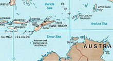
 Location of the Timor Sea
|
| Location
| Eastern
Indian Ocean
,
Asia
,
Oceania
|
|---|
| Coordinates
| 10°S
127°E
/
10°S 127°E
/
-10; 127
|
|---|
| Type
| Sea
|
|---|
| Etymology
| Timor Island
|
|---|
| Part of
| Indian Ocean
|
|---|
| Ocean/sea sources
| Indian Ocean
|
|---|
| Basin
countries
| |
|---|
|
| Surface area
| 610,000 km
2
(240,000 sq mi)
|
|---|
| Average depth
| 406 m (1,332 ft)
|
|---|
| Max. depth
| 3,300 m (10,800 ft)
|
|---|
|
| Islands
| Ashmore and Cartier Islands
,
Browse Island
,
Tiwi Islands
|
|---|
| Trenches
| Timor Trough
|
|---|
| Settlements
| Darwin, Northern Territory
|
|---|
The
Timor Sea
(
Indonesian
:
Laut Timor
,
Portuguese
:
Mar de Timor
,
Tetum
:
Tasi Mane
or
Tasi Timor
) is a relatively shallow sea in the
Indian Ocean
bounded to the north by the island of
Timor
with
Timor-Leste
to the north,
Indonesia
to the northwest,
Arafura Sea
to the east, and to the south by
Australia
. The
Sunda Trench
marks the deepest point of the Timor Sea with a depth of more than 3300 metres, separating the continents of
Oceania
in the southeast and
Asia
to the northwest and north. The Timor sea is prone to earthquakes and tsunamis north of the
Sunda Trench
, due to its location on the
Ring of Fire
as well as volcanic activity and can experience major cyclones, due to the proximity from the
Equator
.
The sea contains a number of reefs, uninhabited islands and significant
hydrocarbon
reserves. International disputes emerged after the reserves were discovered resulting in the signing of the
Timor Sea Treaty
.
The Timor Sea was hit by the worst
oil spill for 25 years in 2009
.
[1]
It is possible that Australia's first inhabitants crossed the Timor Sea from the
Malay Archipelago
at a time when sea levels were lower.
[
citation needed
]
Etymology
[
edit
]
The Timor Sea is named after
Timor
, the island on the other side of the sea's northern coastline.
[2]
The island's name is a variant of
timur
,
Malay
for "east".
In
Tetum
, the sea is often referred to by the expression
tasi mane
(
lit. transl.
'male sea'
). The counterpart of that body of water, the '
Ombai
-
Wetar
Strait', which has smaller waves, is less
turbid
, and washes most of Timor island's northern shores, is commonly referred to in Tetum as
tasi feto
(
lit. transl.
'female sea'
).
[3]
Geography
[
edit
]
 Timor Sea and neighbouring seas
The waters to the east are known as the
Arafura Sea
. The Timor Sea is adjacent to three substantial inlets on the north Australian coast, the
Joseph Bonaparte Gulf
,
Beagle Gulf
and the
Van Diemen Gulf
. The Australian city of
Darwin
which is located in part on the shore of the Beagle Gulf, is the nearest large city to the sea.
[4]
The small town of
Wyndham
is located on the west arm of
Cambridge Gulf
, an inlet of Joseph Bonaparte Gulf.
Rivers that enter the Timor Sea from the Northern Territory include
Fish River
,
King River
,
Dry River
,
Victoria River
and the
Alligator Rivers
. Rivers in the
Kimberley
region that flow into the Timor Sea include the
Ord River
,
Forrest River
,
Pentecost River
and
Durack River
.
The sea is about 480 km (300 mi) wide, covering an area of about 610 thousand km
2
(240,000 sq mi). Its deepest point is the
Timor Trough
(which some geologists consider is the south-eastern extension of the
Java Trench
, but others view as a foreland trough to the Timor Island "mountain range"), located in the northern part of the sea, which reaches a depth of 3,300 m (10,800 ft). The remainder of the sea is much shallower, much of it averaging less than 200 m (660 ft) deep, as it overlies the
Sahul Shelf
, part of the Australian
continental shelf
.
The Big Bank Shoals is an area on the sloping seabed between the continental shelf and the Timor Trough where a number of submerged banks are located.
[5]
The ecosystem of the shoals differs significantly from the deeper waters surrounding them. In May 2010, it was announced that a crater about 50 km (31 mi) wide has been discovered on the seabed of the Timor Sea.
[6]
Extent
[
edit
]
 Tropical cyclone Floyd
over the Timor Sea, 2006
Tropical cyclone Floyd
over the Timor Sea, 2006
The
International Hydrographic Organization
(IHO) defines the Timor Sea as being one of the waters of the
East Indian Archipelago
. The IHO defines its limits as follows:
[7]
On the North
The Southeastern limit of the
Savu Sea
[By a line from the Southwest point of
Timor
to the Northeast point of
Roti
, through this island to its Southwest point] the Southeastern coast of Timor and the Southern limit of the
Banda Sea
[A line from Tanjong Aro Oesoe, through Sermata to Tanjong Njadora the Southeast point of Lakov (
8°16′S
128°14′E
/
8.267°S 128.233°E
/
-8.267; 128.233
) along the South coasts of Lakov, Moa and
Leti Islands
to Tanjong Toet Pateh, the West point of Leti, thence a line to Tanjong Sewirawa the Eastern extremity of Timor].
On the East.
The Western [limit] of the
Arafura Sea
[A line from Cape Don to Tanjong Aro Oesoe, the Southern point of Selaroe (
Tanimbar Islands
)].
On the South.
The North coast of
Australia
from
Cape Don
to
Cape Londonderry
(
13°47′S
126°55′E
/
13.783°S 126.917°E
/
-13.783; 126.917
).
On the West.
A line from Cape Londonderry to the Southwest point of
Roti Island
(
10°56′S
122°48′E
/
10.933°S 122.800°E
/
-10.933; 122.800
).
Meteorology
[
edit
]
Many tropical storms and
cyclones
originate or pass through the Timor Sea. In February 2005, Tropical Cyclone Vivienne disrupted oil and gas production facilities in the area, and the next month, Severe Tropical Cyclone Willy interrupted production.
[
citation needed
]
Petroleum production facilities are designed to withstand the effects of cyclones, although as a safety precaution production work is often reduced or temporarily halted and workers evacuated by helicopter to the mainland - usually to Darwin or
Dili
.
Reefs and islands
[
edit
]
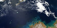
 August 2005 NASA satellite photograph of the
Rowley Shoals
August 2005 NASA satellite photograph of the
Rowley Shoals
A number of significant islands are located in the sea, notably
Melville Island
, part of the
Tiwi Islands
, off Australia and the Australian-governed
Ashmore and Cartier Islands
. It is thought that early humans reached Australia by "island-hopping" across the Timor Sea.
Scott and Seringapatam Reefs
formed in the area and to the west, on the same underwater platform, are the
Rowley Shoals
.
History
[
edit
]
World War II
[
edit
]
During the 1940s the
Japanese navy
conducted
air raids on Australia
from ships in the Timor Sea. On the 19 February 1942 the
Japanese aircraft carrier Kaga
with other vessels, launched
air strikes
against
Darwin, Australia
, sinking nine ships, including the
USS Peary
. This bombing marked the beginning of the
Battle of Timor
in the
Pacific theatre
of
World War II
.
Hydrology
[
edit
]
Timor Current
[
edit
]
The Timor Current is an oceanic current that runs south-west in the Timor Sea between the Malay Archipelago and Australia. It is a major contributor to the
Indonesian Throughflow
that transports water from the
Pacific Ocean
to the
Indian Ocean
.
Hydrocarbon reserves
[
edit
]
 Oil slick from the
Montara oil spill
in the Timor Sea September 2009.
Oil slick from the
Montara oil spill
in the Timor Sea September 2009.
 Big John
Beneath the Timor Sea lie considerable reserves of
oil
and
gas
. Confirmation of the prospectivity of the Timor Sea came when Woodside-Burmah's Big John rig drilled Troubadour No. 1 well in June 1974 on the Troubadour Shoals about 200 kilometres (120 mi) southeast of Timor, and intersected 83 metres (272 ft) of hydrocarbons. A number of offshore petroleum projects are in operation and there is considerable exploration activity either underway and numerous proposed projects. A gas pipeline crosses the Timor Sea from the Joint Petroleum Development Area to
Wickham Point
near Darwin.
[8]
The Timor Sea was the location for Australia's largest
oil spill
when the
Montara oil field
leaked oil, natural gas and
condensate
from 21 August to 3 November 2009.
[9]
During the spill 400 barrels (64 m
3
) of oil leaked each day. The Montara Commission of Inquiry placed blame on the Thai company PTTEP, owner of the wells.
[1]
In response to the disaster, Indonesian seaweed farmers engaged in a class action lawsuit to claim for damages.
[10]
Bayu-Undan project
[
edit
]
The largest petroleum project in operation in the Timor Sea is the Bayu-Undan project operated by
Santos
.
[11]
The Bayu-Undan field is located approximately 500 km (310 mi) north-west of
Darwin
in the
Bonaparte Basin
.
[12]
Production commenced in 2004 as a gas recycle project - with liquids (condensate, propane and butane) being stripped from the raw production stream and exported. Gas was pumped back down into the reservoir. At around the same time, construction commenced on a 500 km (310 mi) subsea
natural gas pipeline
connecting the Bayu-Undan processing facility to a
liquefied natural gas
plant situated at Wickham Point in
Darwin
harbour. Since the completion of the pipeline and the Darwin LNG plant in 2005, gas produced offshore at Bayu-Undan is now transported to the Darwin plant where it is converted into a liquid and transported to
Japan
under long-term sales contracts.
[13]
Timor-Leste has made, as of 2017, over $18 billion from Bayu-Undan since production began; however, it is predicted its reserves will be exhausted by 2023.
[14]
Ichthys gas field
[
edit
]
The
Ichthys gas field
is a
natural gas field
located in the Timor Sea, off the northwestern coast of
Australia
. The field is located 220 km offshore Western Australia and 820 km southwest of Darwin, with an average water depth of approximately 250 metres.
[15]
It was discovered in 2000. First Gas from the Ichthys field was achieved on 30 July 2018.
[16]
Other projects
[
edit
]
AED Oil
owns the large oil project at Puffin oilfield and
Woodside Petroleum
is producing oil at the Laminaria oilfield. The Greater Sunrise
gas field
, discovered in 1974, is one of the largest in the area and is expected to earn East Timor several billion dollars in royalty revenues. Woodside Petroleum plans to process gas from Greater Sunrise via a
floating platform
, however
Xanana Gusmao
, East Timor's Prime Minister opposes this plan and instead wants the gas to go to
Beaco
via a
pipeline
for processing.
[17]
Since 2018,
Santos
has sought to establish the Barossa offshore gas project to exploit a gas field in order to supply the Darwin
liquefield natural gas
(LNG) onshore terminal when gas from
Bayu-Undan
runs out in the 2020s. This has been opposed by Dangalaba and
Larrakia
people as well as climate justice organisations.
[10]
Territorial dispute
[
edit
]
 Demonstration against Australia in December 2013
Since the discovery of petroleum in the Timor Sea in the 1970s, there have been disputes surrounding the rights to ownership and exploitation of the resources situated in a part of the Timor Sea known as the
Timor Gap
, which is the area of the Timor Sea which lies outside the territorial boundaries of the nations to the north and south of the Timor Sea.
[18]
These disagreements initially involved Australia and Indonesia, although a resolution was eventually reached in the form of the
Timor Gap Treaty
. After declaration of East Timor's nationhood in 1999, the terms of the Timor Gap Treaty were abandoned and negotiations commenced between Australia and East Timor, culminating in the
Timor Sea Treaty
.
From 1965 to 2018, Australia's territorial claim extended to the bathymetric axis (the line of greatest sea-bed depth) at the Timor Trough. It overlapped East Timor's own territorial claim, which followed the former colonial power
Portugal
and the
United Nations Convention on the Law of the Sea
in claiming that the dividing line should be midway between the two countries. In 2018, Australia agreed to a median line boundary.
It was revealed in 2013 that the
Australian Secret Intelligence Service
(ASIS) planted listening devices to listen to East Timor during negotiations over the Greater Sunrise oil and gasfields. This is known as the
Australia?East Timor spying scandal
.
Timor Sea Treaty
[
edit
]
The
Timor Sea Treaty
, which was signed on the 20 May 2002, led to the establishment of the Timor Sea Designated Authority (TSDA). This organisation is responsible for the administration of all petroleum-related activities in a part of the Timor Sea known as the Joint Petroleum Development Area (JPDA). The treaty was ratified in February 2007.
[18]
Under the terms of the treaty, royalties on petroleum production in the JPDA are split in a 90:10 ratio between
East Timor
and
Australia
.
[19]
It has been criticised because the treaty did not finalise the
maritime boundary
between East Timor and Australia.
[18]
2018 Maritime Boundaries Treaty
[
edit
]
The
Australia?Timor Leste Treaty Establishing Their Maritime Boundaries in the Timor Sea
was signed on 6 March 2018 at United Nations headquarters in New York in the presence of United Nations Secretary-General Antonio Guterres.
[20]
See also
[
edit
]
References
[
edit
]
- ^
a
b
Andrew Burrell (29 April 2011).
"Montara oil spill firm seeks permission for more drills"
.
The Australian
. News Limited
. Retrieved
22 May
2011
.
- ^
Ormeling, Ferjan (2000).
"Sea Names Categories and Their Implications"
(PDF)
.
Journal of Geography Education, 44
.
44
: 54?61
. Retrieved
15 April
2022
.
- ^
Hunnam, Kimberley; Carlos, Imelda; Hammer, Michael P.; Dos Reis Lopes, Joctan; Mills, David J.; Stacey, Natasha (2021).
"Untangling Tales of Tropical Sardines: Local Knowledge From Fisheries in Timor-Leste"
.
Frontiers in Marine Science
.
8
.
doi
:
10.3389/fmars.2021.673173
.
hdl
:
1885/277964
.
ISSN
2296-7745
.
- ^
"Survey Plan CP/5090 - localities within the Tiwi sub-region"
.
Place Names Committee
. Northern Territory Government of Australia. 5 April 2007
. Retrieved
1 May
2019
.
- ^
"Big Bank Shoals of the Timor Sea"
. Australian Institute of Marine Science. 30 August 2001
. Retrieved
4 June
2010
.
- ^
Jess Teideman (21 May 2010).
"Vast asteroid crater found in Timor Sea"
.
Australian Geographic
. Archived from
the original
on 24 May 2010
. Retrieved
31 May
2010
.
- ^
"Limits of Oceans and Seas, 3rd edition"
(PDF)
. International Hydrographic Organization. 1953. p. 28
. Retrieved
28 December
2020
.
- ^
"Santos - Our Activities - Timor Sea"
.
Santos
. Archived from
the original
on 13 October 2010
. Retrieved
23 October
2010
.
- ^
"Huge oil spill plugged at last - rig owner"
.
The Australian
.
News Limited
. 3 November 2009
. Retrieved
3 November
2009
.
- ^
a
b
Commons Librarian (22 December 2023).
"Campaigns that Changed the Northern Territory"
.
The Commons Social Change Library
. Retrieved
5 April
2024
.
- ^
"Santos Completes Acquisition of ConocoPhillips' Australia Assets"
. OE Digital. 28 May 2020
. Retrieved
28 May
2020
.
- ^
"Bayu Undan / Darwin LNG"
.
Santos Limited
. Retrieved
21 December
2018
.
- ^
Darwin LNG
- ^
"Timor-Leste's big-spending leaders are squandering its savings"
.
The Economist
. 4 May 2017
. Retrieved
5 May
2017
.
- ^
"Project map"
.
INPEX
. Retrieved
1 October
2018
.
- ^
"UPDATE 1-Inpex's Ichthys LNG produces first gas off Australia"
.
U.S
. Reuters. 30 June 2018
. Retrieved
1 October
2018
.
- ^
"East Timor's Prime Minister Xanana Gusmao accuses Woodside of lying"
.
news.com.au
.
News Limited
. 27 May 2010
. Retrieved
31 May
2010
.
- ^
a
b
c
Richard Baker (21 April 2007).
"New Timor treaty 'a failure'
"
.
Theage.com.au
. The Age Company Ltd
. Retrieved
3 January
2010
.
- ^
"Joint Petroleum Development Area Fact sheet"
(PDF)
. Retrieved
29 January
2008
.
- ^
Australian Senate Economics Legislation Committee,
Report: Timor Sea Maritime Boundaries Treaty Consequential Amendments Bill 2018 [Provisions] and the Passenger Movement Charge Amendment (Timor Sea Maritime Boundaries Treaty) Bill 2018
[Provisions], 8 February 2019
; Hao Duy Phan, Tara Davenport and Robert Beckman (eds.),
Timor-Leste/Australia Conciliation: A Victory for UNCLOS and Peaceful Settlement,
Centre for International Law, National University of Singapore, 2019.
External links
[
edit
]
Wikimedia Commons has media related to
Timor Sea
.
List of Australian seas
|
|---|
| Ocean
| |
|---|
| Sea
| |
|---|
| Strait
| |
|---|
| Gulf
| |
|---|
|
Indonesian seas
|
|---|
|
| Ocean
| |
|---|
| Sea
| |
|---|
| Strait
| |
|---|
| Gulf
| |
|---|
|
|
|---|
| International
| |
|---|
| National
| |
|---|
| Other
| |
|---|