From Wikipedia, the free encyclopedia
Province of Turkey
Province and metropolitan municipality in Turkey
Tekirda? Province
(
Turkish
:
Tekirda? ili
,
pronounced
[te?ci?daː]
) is a
province
and
metropolitan municipality
of
Turkey
. Its area is 6,190 km
2
,
[2]
and its population is 1,142,451 (2022).
[1]
It is located in the
East Thrace
region of the country, also known as European Turkey, one of only three provinces entirely within continental
Europe
. Tekirda? Province is bordered by
Istanbul Province
to the east,
Kırklareli Province
to the north,
Edirne Province
to the west, and the
Gallipoli
peninsula of
Canakkale Province
to the south.
Tekirda?
is the capital of the province, and the third largest city in European Turkey after
Istanbul
and
Corlu
.
Agriculture
[
edit
]
The province of Tekirda? is one of Turkey's the most important regions for
viticulture
and
winemaking
. The coastline between
Tekirda?
and
?arkoy
, particularly
Murefte
, are notable centers of wineyards. 22 of the 27 villages of ?arkoy grow grape and produce wine. There are well-known wine producers in the region, including "Doluca", "Gulor", "Kutman", "Ba?cı" and "Latif Aral". Other wine producers of the region are "Melen" in
Ho?koy
and "Umurbey" in Tekirda?.
[3]
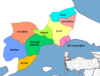
 Districts of Tekirda? Province
Places of Interest
[
edit
]
Districts
[
edit
]
References
[
edit
]
External links
[
edit
]
 Media related to
Tekirda? Province
at Wikimedia Commons
Media related to
Tekirda? Province
at Wikimedia Commons
41°05′11″N
27°21′28″E
/
41.08639°N 27.35778°E
/
41.08639; 27.35778
|
|---|
| Districts
| |   Districts of Tekirda? Districts of Tekirda?
|
|---|
|
|
|
|---|
| International
| |
|---|
| National
| |
|---|
| Geographic
| |
|---|
