Cape in Malacca, Malaysia
Exclave of Malacca in Malaysia
 Tanjung Tuan as viewed over the estuary of the
Linggi River
, on the northern extremity of the Malaccan coastline.
Tanjung Tuan as viewed over the estuary of the
Linggi River
, on the northern extremity of the Malaccan coastline.
Tanjung Tuan
(
Lord's Cape
, formerly known as
Cape Rachado
as named by the
Portuguese
, meaning 'broken cape') is an area in
Alor Gajah District, Malacca
, Malaysia. It is a
semi-exclave
of
Malacca
adjacent to
Port Dickson
,
[1]
Negeri Sembilan
.
The
cape
is well known for the
Cape Rachado Lighthouse
facing the
Strait of Malacca
. The coastal area off the cape is famous as the site of the naval
Battle of Cape Rachado
in 1606, between the
Dutch East India Company
(VOC) and Portuguese fleets.
[2]
The battle was the opening act for the series of conflicts between the Dutch-
Johor
coalition and
Portuguese Malacca
that ultimately ended with the Portuguese surrender of the city and fort of Malacca to the VOC in 1641.
Lighthouse
[
edit
]
 Cape Rachado Lighthouse
After Portugal conquered Malacca in 1511, the Portuguese wanted to build a lighthouse to guide its ships. Tanjung Tuan was chosen and the cape was named Cape Rachado by them. Subsequently, a lighthouse was built between 1528 and 1529. As Malacca switched hands to the Dutch and later to the British in 1641 and 1824 respectively, so too did the possession of the structure.
Forest reserve
[
edit
]
 Beach in Tanjung Tuan.
In 1921, the area was gazetted as a permanent forest reserve under
Gazette No. : 2066 dated 23 December, 1921 (No.Warta : 2066 bertarikh 23 Disember, 1921)
with 809,700 square metres under the name of
Cape Rachado Forest Reserve
. However, in 1969 an area of 161,900 square metres was degazetted from the permanent forest reserve status for the purpose of public use under
Gazette No. : 328 dated 25 December, 1969 (No.Warta : 328 bertarikh 25 Disember, 1969)
.
On 5 January 1971, The rest of the 607,000 square metres of the Cape Rachado forest reserves was gazetted as a wildlife sanctuary under the jurisdiction of PERHILITAN (forestry and wildlife protection department) under
M.P.U.5
and
PG No: 85
under the
Birds and Wild Life Protection Ordinance, 1955
(
Ordinan Perlindungan Binatang-Binatang Liar dan Burung-Burung, 1955
).
On 16 April 1996, private company Dataran Baiduri Sdn Bhd was assigned to commercially develop the park.
This area has been designated by
BirdLife International
as an
Important Bird Area
. The
Malaysian Nature Society
is active in promoting conservation in the area.
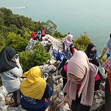 Batu Putih peak is popular among local weekend hikers.
Puncak Batu Putih in Tanjung Tuan is popular for hikers for short hiking experience during the weekend.
Two islets are located at the tip of Tanjung Tuan, Intan Island to the south and Masjid Island to the east.
[3]
Burial Place
[
edit
]
It has also believed that Tanjung Tuan is the place where
Parameswara
(1344 ? c. 1414), the last king of
Singapura
and the founder of
Malacca
was buried. Parameswara was succeeded by his son,
Megat Iskandar Shah
who in turn ruled Malacca until 1424. There is an allegation that Parameswara had also been buried at the
Bukit Larangan
Park,
Singapore
. Some other also believe that he could have been cremated based on the Hindu's ritual belief system as people cannot find his actual buried place.
[4]
Further reading
[
edit
]
Concerning the battle of Cape Rachado in 1606:
- Borschberg, Peter,
Journal, Memorials and Letters of Cornelis Matelieff de Jonge. Security, Diplomacy and Commerce in 17th Century Southeast Asia,
NUS Press, 2015.
https://www.academia.edu/4302783
- Borschberg, Peter,
The Singapore and Malacca Straits. Violence, Security and Diplomacy in the 17th Century,
NUS Press, 2010.
https://www.academia.edu/4302722
- Borschberg, Peter, "The value of Admiral Matelieff's writings for the history of Southeast Asia, c.1600?1620",
Journal of Southeast Asian Studies,
48(3), pp. 414?435. DOI:
https://doi.org/10.1017/S002246341700056X
See also
[
edit
]
Notes and references
[
edit
]
|
|---|
| Islands
| |
|---|
| Seas
| |
|---|
| Exclaves
| |
|---|
| Rivers
| |
|---|
|
|---|
|
| Topics
| |
|---|
| Society
| |
|---|
Administrative
divisions
| | Districts
| |
|---|
| Cities/Municipalities
| |
|---|
| Towns and suburbs
| |
|---|
| Residential neighbourhoods
| |
|---|
| Villages
| |
|---|
| Exclaves
| |
|---|
| Islands
| |
|---|
|
|---|
|