Earth Weather Satellite
The
Suomi National Polar-orbiting Partnership
(
Suomi NPP
), previously known as the
National Polar-orbiting Operational Environmental Satellite System Preparatory Project
(
NPP
) and
NPP-Bridge
, is a
weather satellite
operated by the United States
National Oceanic and Atmospheric Administration
(NOAA). It was launched in 2011 and is currently in operation.
Suomi NPP was originally intended as a pathfinder for the
National Polar-orbiting Operational Environmental Satellite System
(NPOESS) program, which was to have replaced NOAA's
Polar Operational Environmental Satellites
(POES) and the
U.S. Air Force
's
Defense Meteorological Satellite Program
(DMSP). Suomi NPP was launched in 2011 after the cancellation of NPOESS to serve as a stop-gap between the POES satellites and the
Joint Polar Satellite System
(JPSS) which will replace them. Its instruments provide climate measurements that continue prior observations by
NASA
's
Earth Observing System
(EOS).
Name
[
edit
]
The satellite is named after
Verner E. Suomi
, a Finnish-American meteorologist at the
University of Wisconsin?Madison
. The name was announced on 24 January 2012, three months after the satellite's launch.
[4]
[5]
The satellite was launched from
Space Launch Complex-2W
(SLC-2W) at
Vandenberg Space Force Base
in
California
by a
United Launch Alliance
Delta II
7920-10C on 28 October 2011. The satellite was placed into a
Sun-synchronous orbit
(SSO) 833 km (518 mi) above the
Earth
.
[6]
History
[
edit
]
NPOESS Preparatory Project (NPP)
is intended to bridge the gap between old
Earth Observing System
(EOS) and new systems (JPSS) by flying new instruments, on a new satellite bus, using a new ground data network.
[7]
Originally planned for launch five years earlier as a joint
NASA
/
NOAA
/
DoD
project, NPP was to be a pathfinder mission for the larger
National Polar-orbiting Operational Environmental Satellite System
(NPOESS) until DoD participation in the larger project was dissolved. The project continued as a civilian weather forecasting replacement for the NOAA
Polar Operational Environmental Satellites
(POES) series, and ensured continuity of climate measurements begun by the
Earth Observing System
(EOS) of NASA.
[8]
Launch
[
edit
]
The spacecraft was launched on 28 October 2011 at from
Vandenberg Space Force Base
via a
Delta II
in the 7920-10 configuration (Extra Extended Long Tank with
RS-27A
engine first stage, 9
GEM-40
solid rocket motors, type 2 second stage with
Aerojet
AJ10
-118K engine, no third stage and a 10-foot fairing).
[9]
[10]
Additionally, the rocket deployed five
CubeSats
as a part of
NASA ELaNa III manifest
.
Spacecraft
[
edit
]
 Suomi NPP in the cleanroom before launch
The Suomi NPP spacecraft has been built and integrated by BATC (Ball Aerospace and Technologies Corporation) of Boulder, Colorado (NASA/GSFC contract award in May 2002). The platform design is a variation of BCP 2000 (Ball Commercial Platform) bus of BATC of
ICESat
and
CloudSat
heritage. The spacecraft consists of an
aluminum
honeycomb structure.
The ADCS (Attitude Determination and Control Subsystem) provides 3-axis stabilization using 4
reaction wheels
for fine attitude control, 3 torquer bars for momentum unloading, thrusters for coarse attitude control (such as during large-angle slews for orbital maintenance), 2
star trackers
for fine attitude determination, 3
gyroscopes
for attitude and attitude rate determination between star tracker updates, 2 Earth sensors for safe-mode attitude control, and coarse Sun sensors for initial attitude acquisition, all monitored and controlled by the spacecraft controls a computer. ADCS provides real-time attitude knowledge of 10
arcsec
(1 sigma) at the spacecraft navigation reference base, real-time spacecraft position knowledge of 25 m (1 sigma), and
attitude control
of 36 arcsec (1 sigma).
The EPS (Electrical Power Subsystem) uses
Gallium arsenide
(GaAs)
solar cells
to generate an average power of about 2 kW (EOL). The
solar array
rotates once per orbit to maintain a nominally normal orientation to the Sun. In addition, a single-wing solar array is mounted on the anti-solar side of the spacecraft; its function is to preclude thermal input into the sensitive cryo radiators of the
Visible Infrared Imaging Radiometer Suite
(VIIRS) and Cross-track Infrared Sounder (CrIS) instruments. A regulated 28 ±6 VDC power bus distributes energy to all spacecraft subsystems and instruments. A
nickel?hydrogen battery
(NiH) system provides power for
eclipse
phase operations.
The spacecraft has an on-orbit design lifetime of 5 years (available consumables for 7 years). The spacecraft dry mass is about 1400 kg. NPP is designed to support controlled reentry at the end of its mission life (via propulsive maneuvers to lower the orbit perigee to approximately 50 km and target any surviving debris for open ocean entry). NPP is expected to have sufficient debris that survives reentry so as to require controlled reentry to place the debris in a pre-determined location in the ocean.
Instruments
[
edit
]
The Suomi NPP is the first in a new generation of satellites intended to replace the
Earth Observing System
(EOS) satellites, which were launched from 1997 to 2009. The satellite orbits the Earth about 14 times each day. Its five imaging systems include:
Visible Infrared Imaging Radiometer Suite (VIIRS)
[
edit
]
The
Visible Infrared Imaging Radiometer Suite
(VIIRS) is the largest instrument aboard of Suomi-NPP (National Polar-Orbiting Operational Environmental Satellite System (
NPOESS
) Preparatory Project). It collects radiometric imagery in
visible
and
infrared
wavelengths of the land, atmosphere, ice, and ocean. It will survey broad swaths of the land, oceans, and air, enabling scientists to monitor everything from
phytoplankton
and other organisms in the sea, vegetation and forest cover, and the amount of sea ice at the poles. Data from VIIRS, collected from 22 channels across the
electromagnetic spectrum
, will also be used to observe active fires, ocean color,
sea surface temperature
, and other surface features.
[11]
Ozone Mapping and Profiler Suite (OMPS)
[
edit
]
The
Ozone Mapping and Profiler Suite
(OMPS) measures the
ozone layer
in our
upper atmosphere
tracking the status of global ozone distributions, including the
ozone hole
. It also monitors ozone levels in the
troposphere
. OMPS extends out 40-year long record ozone layer measurements while also providing improved vertical resolution compared to previous operational instruments. Closer to the ground, OMPS's measurements of harmful ozone improve air quality monitoring and when combined with cloud predictions; help to create the
Ultraviolet index
. OMPS has two sensors, both new designs, composed of three advanced hyperspectral-imaging spectrometers.
[12]
Clouds and the Earth's Radiant Energy System (CERES)
[
edit
]
The
Clouds and the Earth's Radiant Energy System
(CERES) will be used to study the
Earth's radiation budget
. Monitoring the amount of energy emitted and reflected by the planet, it measures both
solar energy
reflected by the
Earth
and heat emitted by our planet. This solar and thermal energy are key parts of the Earth's radiation budget. CERES instrument continues a multi-year record of the amount of energy entering and exiting from the top of the
atmosphere of Earth
. It will provide scientists with needed long-term, stable data sets to make accurate projections of global climate change.
[13]
Cross-track Infrared Sounder (CrIS)
[
edit
]
The
Cross-track Infrared Sounder
(CrIS) has 1305 spectral channels and will produce high-resolution, three-dimensional temperature, pressure, and moisture profiles. It measures continuous channels in the infrared region and has the ability to measure temperature profiles with improved accuracy over its predecessors. These profiles will be used to enhance weather forecasting models and will facilitate both short- and long-term weather forecasting. Over longer timescales, they will help improve understanding of climate phenomena.
[14]
Advanced Technology Microwave Sounder (ATMS)
[
edit
]
The
Advanced Technology Microwave Sounder
(ATMS), works in conjunction with the Cross-track Infrared Sounder (CrIS) to make detailed vertical profiles of atmospheric pressure, heat, and moisture. ATMS, a cross-track scanner with 22 channels, provides sounding observations needed to retrieve profiles of atmospheric temperature and moisture for civilian operational weather forecasting as well as continuity of these measurements for climate monitoring purposes. CrIS will operate at infrared wavelengths, while ATMS will operate at much shorter, microwave, wavelengths.
[15]
Mission
[
edit
]
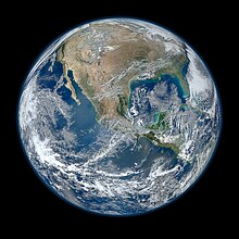 Blue Marble 2012, created from Suomi NPP composite imagery
The VIIRS sensor on board the spacecraft acquired its first measurements of Earth on 21 November 2011.
[16]
NASA also released a high resolution
blue marble
image of the Earth showing most of
North America
, which was created by NASA oceanographer Norman Kuring using data obtained on 4 January 2012 by the Visible Infrared Imager Radiometer Suite (VIIRS), one of five imaging systems aboard the satellite. That date was chosen because it was a fairly sunny day in most of North America.
[6]
As of 22 November 2020
[update]
, beyond the initial 5-year mission, the spacecraft continues to operate.
[17]
Gallery
[
edit
]
Earth, created from Suomi NPP composite imagery.
Earth at night, created from Suomi NPP composite imagery.
-
Delta II rocket carrying NPP.
-
NPP launch video
-
First image acquired by the VIIRS sensor.
-
This composite image of southern Africa and the surrounding oceans was captured by six orbits of the satellite.
-
Iowa power outage
-
Lac-Megantic derailment
References
[
edit
]
- ^
"NPP Press Kit"
. NASA
. Retrieved
6 January
2021
.
 This article incorporates text from this source, which is in the
public domain
.
This article incorporates text from this source, which is in the
public domain
.
- ^
@NASAKennedy.
"#NPP's official liftoff time was 02:48:01.828 PDT"
. Twitter
. Retrieved
17 August
2013
.
This article incorporates text from this source, which is in the
public domain
.
- ^
"NPP Satellite details 2011-061A NORAD 37849"
. N2YO. 25 January 2015
. Retrieved
25 January
2015
.
- ^
Gran, Rani; Steve Cole (25 January 2012).
"NASA Renames Earth-Observing Mission in Honor of Satellite Pioneer"
.
Suomi NPP
. NASA
. Retrieved
29 January
2012
.
This article incorporates text from this source, which is in the
public domain
.
- ^
Herzog, Karen (26 January 2012).
"Satellite renamed to honor UW's Suomi"
.
Milwaukee Journal Sentinel
. Milwaukee
. Retrieved
29 January
2012
.
- ^
a
b
Netburn, Deborah (26 January 2012).
"The making of NASA's super hi-res blue marble Earth image"
.
Los Angeles Times
. Retrieved
29 January
2012
.
- ^
"NPP Mission"
. NASA. Archived from
the original
on 26 October 2001
. Retrieved
15 August
2011
.
This article incorporates text from this source, which is in the
public domain
.
- ^
NASA.gov
This article incorporates text from this source, which is in the
public domain
.
- ^
History of the Delta Launch Vehicle: Description and Designations
- ^
"NPP weather and climate satellite launches"
. BBC News. 28 October 2011.
- ^
"VIRSS 2011-061A"
. NASA. 14 May 2020
. Retrieved
7 January
2021
.
This article incorporates text from this source, which is in the
public domain
.
- ^
"OMPS 2011-061A"
. NASA. 14 May 2020
. Retrieved
7 January
2021
.
This article incorporates text from this source, which is in the
public domain
.
- ^
"CERES 2011-061A"
. NASA. 14 May 2020
. Retrieved
7 January
2021
.
This article incorporates text from this source, which is in the
public domain
.
- ^
"CrIS 2011-061A"
. NASA. 14 May 2020
. Retrieved
7 January
2021
.
This article incorporates text from this source, which is in the
public domain
.
- ^
"ATMS 2011-061A"
. NASA. 14 May 2020
. Retrieved
7 January
2021
.
This article incorporates text from this source, which is in the
public domain
.
- ^
VIIRS First Light
This article incorporates text from this source, which is in the
public domain
.
- ^
"SNPP Operational Status"
. NOAA. 14 April 2016
. Retrieved
6 January
2021
.
This article incorporates text from this source, which is in the
public domain
.
External links
[
edit
]
Wikimedia Commons has media related to
Suomi NPP
.
|
|---|
| January
| |
|---|
| February
| |
|---|
| March
| |
|---|
| April
| |
|---|
| May
| |
|---|
| June
| |
|---|
| July
| |
|---|
| August
| |
|---|
| September
| |
|---|
| October
| |
|---|
| November
| |
|---|
| December
|
- Compass-IGSO5
- Amos-5
,
Luch 5A
- IGS Radar 3
- Pleiades-HR 1A
,
SSOT
,
ELISA 1
,
ELISA 2
,
ELISA 3
,
ELISA 4
- NigComSat-1R
- Soyuz TMA-03M
- Ziyuan-1C
- Meridian 5
- Globalstar M080
,
Globalstar M082
,
Globalstar M084
,
Globalstar M086
,
Globalstar M090
,
Globalstar M092
|
|---|
Launches are separated by dots ( ? ), payloads by commas ( , ), multiple names for the same satellite by slashes ( / ).
Crewed flights
are underlined. Launch failures are marked with the † sign. Payloads deployed from other spacecraft are (enclosed in parentheses).
|