Public park in Dublin, Ireland
St Stephen's Green
(
Irish
:
Faiche Stiabhna
)
[2]
is a
garden square
and
public park
located in the
city centre
of
Dublin
, Ireland. The current landscape of the park was designed by William Sheppard. It was officially re-opened to the public on Tuesday, 27 July 1880 by
Lord Ardilaun
.
[3]
[4]
The square is adjacent to one of Dublin's main shopping streets,
Grafton Street
, and to a
shopping centre
named after it, while on its surrounding streets are the offices of a number of public bodies as well as a stop on one of Dublin's
Luas
tram lines. It is often informally called Stephen's Green. At 22 acres (8.9 ha), it is the largest of the parks in Dublin's main Georgian
garden squares
. Others include nearby
Merrion Square
and Fitzwilliam Square.
The park is rectangular, surrounded by streets that once formed major traffic arteries through Dublin city centre, although traffic management changes implemented in 2004 during the course of the Luas works
[5]
have greatly reduced the volume of traffic. These four bordering streets are called, respectively, St Stephen's Green North, St Stephen's Green South, St Stephen's Green East and St Stephen's Green West.
History
[
edit
]
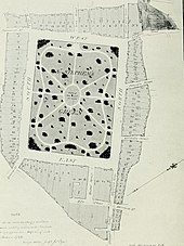
 St Stephen's Green,
Herman Moll
's 1714 map of Dublin
St Stephen's Green,
Herman Moll
's 1714 map of Dublin
 Photochrom print showing the green at the end of the 19th century
 The Green in 1832
The association with St Stephen has its origins in a medieval leper hospital, now
Mercer's Hospital
, dedicated to
Saint Stephen
on nearby Stephen Street.
[6]
Until 1663, St Stephen's Green was a marshy
common
on the edge of Dublin of approximately 60 acres, used for grazing. In that year
Dublin Corporation
, seeing an opportunity to raise much-needed revenue, decided to enclose the centre of the common and to sell land around the perimeter for building. The area was surveyed by Robert Newcomen, with the land divided into 96 plots with a green of 27 acres in the centre. The park was enclosed with a wall in 1664. Early tenants built simple two-storey houses, with much of it undeveloped on the 1728 map. By the time of
John Roque
's map in 1756, the pace of building had accelerated rapidly.
The houses built around the Green were rapidly replaced by new buildings in the
Georgian style
and by the end of the eighteenth century the Green was a place of resort for the better-off of the city. Most of the present-day landscape of the square comprises townhouses from the 18th and 19th centuries.
[8]
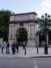 Fusiliers' Arch
, erected in 1907
Fusiliers' Arch
, erected in 1907
United Kingdom legislation
| Saint Stephen's Green (Dublin) Improvement Act 1814
|
|---|
|
 |
| Long title
| An Act for the Improvement of the square called Saint Stephen's Green in the city of Dublin.
|
|---|
| Citation
| 54 Geo. 3
. c. ccviii
|
|---|
|
| Repealed by
| Saint Stephen's Green (Dublin) Act 1877
|
|---|
|
In 1814 control of St Stephen's Green passed to commissioners for the local householders, who redesigned its layout and replaced the walls with railings.
[9]
After the death of
Prince Albert
,
Queen Victoria
suggested that St Stephen's Green be renamed Albert Green and have a statue of Albert at its centre, a suggestion rejected with indignation by the Dublin Corporation and the people of the city, to the Queen's chagrin.
[10]
United Kingdom legislation
| Saint Stephen's Green (Dublin) Act 1877
|
|---|
|
 |
| Long title
| An Act to vest Saint Stephen's Green, Dublin, in the Commissioners of Public Works in Ireland; for maintaining and regulating the same as a Public Park; and for other purposes.
|
|---|
| Citation
| 40 & 41 Vict.
c. cxxxiv
|
|---|
|
| Repeals/revokes
| - Saint Stephen's Green (Dublin) Improvement Act 1814
|
|---|
|
Access to the Green was restricted to local residents, until 1877, when Parliament passed an Act to reopen St Stephen's Green to the public, at the initiative of
Sir A.E. Guinness
, a member of the
Guinness brewing family
who lived at
St Anne's Park
,
Raheny
and at
Ashford Castle
. He later paid for the laying out of the Green in approximately its current form, which took place in 1880, and gave it to the
Corporation
, as representatives of the people. By way of thanks, the city commissioned a statue of him, which faces the
College of Surgeons
. His brother
Edward
lived at
Iveagh House
, which his descendants gave in 1939 to the Department of External Affairs (now the Department of Foreign Affairs).
During the
Easter Rising
of 1916, a group of rebels made up mainly of members of the
Irish Citizen Army
, under the command of Commandant
Michael Mallin
, his second-in-command
Kit Poole
, and
Constance Markievicz
, established a position in St Stephen's Green.
They numbered between 200 and 250.
[12]
They confiscated motor vehicles to establish roadblocks on the streets that surround the park, and dug defensive positions in the park itself. This approach differed from that of taking up positions in buildings, adopted elsewhere in the city. It proved to have been unwise when elements of the
British Army
took up positions in the
Shelbourne Hotel
, at the northeastern corner of St Stephen's Green, overlooking the park, from which they could shoot down into the entrenchments.
Finding themselves in a weak position, the Volunteers withdrew to the
Royal College of Surgeons
on the west side of the Green.
[12]
During the Rising, gunfire was temporarily halted to allow the park's groundsman to feed the local ducks.
[13]
A statue of
Archibald Montgomerie, 13th Earl of Eglinton
by
Patrick MacDowell
was erected on the North side of the green in 1866. It was destroyed in an explosion by the IRA which injured
gardai
and civilians in 1958 and the remains were dismantled.
[14]
[15]
The park is now operated by the
Office of Public Works
(OPW) on behalf of the Irish state.
[16]
Park
[
edit
]
Evolution of design
[
edit
]
 St Stephen's Green fountain in summer
The landscaping of the park has undergone three major changes since its inception. Its first major change occurred in 1670: two rows of
lime trees
were planted around the perimeter, functioning as its first enclosure. The marshy ground was drained using a ditch at the perimeter.
At this time, the park was only accessible to the wealthy residents who owned plots around the park. In 1815 the park was redesigned by the Dublin
city surveyor
Arthur Neville. In his redesign, he added winding pathways and iron fences. At this time, the park was still closed to the public.
[3]
During the 1860s, the campaign to make the park publicly accessible was underway, and the
city engineer
, George W. Hemans,
[18]
proposed a new design to make the park as walkable and as functionally practical as possible. This included creating four gates at each corner of the park that would be linked by the extant pathways designed by Neville. This plan was eventually abandoned, most likely due to the fact that Hemans was employed by
Dublin Corporation
. However, many of Hemans' designs, like the addition of the gates and connecting pathways, were included in the final plans submitted by William Sheppard, the principal designer responsible for the landscape of the park as we know it today, and engineer A.L. Cousins, sponsored by
Lord Ardilaun
. Ardilaun also played a significant role in the planning and importing of the exotic trees and plants that would be installed in the park.
[3]
Layout
[
edit
]
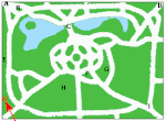 Map of Green with some key features: (A) Fusiliers' Arch (B) O'Donovan Rossa (C) O'Connell Bridge (D) WolfeTone & Famine Memorial (E) Lord Ardilaun (F) Markievicz (G) Playground (H) Bandstand (I)
Three Fates
Map of Green with some key features: (A) Fusiliers' Arch (B) O'Donovan Rossa (C) O'Connell Bridge (D) WolfeTone & Famine Memorial (E) Lord Ardilaun (F) Markievicz (G) Playground (H) Bandstand (I)
Three Fates
 Three Fates
statue
Three Fates
statue
 Statue of
George II
, which stood from 1758 to 1937
Statue of
George II
, which stood from 1758 to 1937
While the central park of St Stephen's Green is one of three ancient
commons
in the city, its current layout owes much to the restorations of the 19th century. Architectural history professor Christine Casey states that this restoration obscures what would have been its most impressive feature to 18th-century visitors, its large size.
The grounds are roughly rectangular, measuring (approximately) 550 by 450 metres, and are centred on a formal garden.
By 1758, the tree-lined walks around the park had been named, Beaux Walk to the north, Leeson's Walk to the south, Monck's Walk to the east, and French Walk to the west.
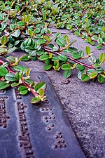 Braille notice next to
Cotoneaster
Braille notice next to
Cotoneaster
One of the more unusual aspects of the park lies on the northwest corner of this central area, a garden for the blind with scented plants, which can withstand handling, and are labelled in
Braille
.
Further north again (and spanning much of the length of the park) is a large lake. Home to ducks and other
water fowl
, the lake is fed by an artificial waterfall, spanned by O'Connell bridge, and fronted by an ornamental
gazebo
. The lakes in the park are fed from the
Grand Canal
at
Portobello
.
To the south side of the main garden circle is more open
heath
surrounding a
bandstand
, and often frequented by lunching students, workers and shoppers on Dublin's sunnier days.
There is also a playground (separated into junior and senior areas) which was refurbished in 2010.
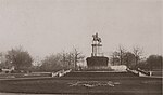
The park once featured a statue of King
George II
on horseback by John van Nost,
erected in 1758, until it was blown up in 1937 by
Irish Republicans
, the day after the
coronation
of
George VI
.
[19]
[20]
Other features include:
Architecture
[
edit
]
 Iveagh House
 73-76 St Stephen's Green undergoing demolition in April 1965
 70-77 St Stephen's Green, Dublin in 1964 undergoing demolition
Some of the earliest houses still survive on the south and north sides of the Green. These are identifiable by their lower height and narrow fronts, illustrating how plots were subdivided. Later buildings on the east side show a dramatic change in scale, with much larger and grander houses, many by
Gustavus Hume
.
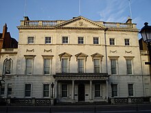
Iveagh House
on the south side was created from the joining of two earlier houses (numbers 80 and 81) by
Benjamin Guinness
in the 1860s. It was donated to the Irish State by the Guinness family in 1939, and now houses the main offices of the
Department of Foreign Affairs
.
Also on the south side of St Stephen's Green are
Newman House
(numbers 85 and 86, after
John Henry Newman
) and
University Church
. These are home to the Catholic University of Ireland, which was founded in the 19th century. It is linked with
University College Dublin
, but is no longer active educationally in its own right.
The
Unitarian
Church
, Dublin, built in the
Gothic revival
style, is located on the West side of St Stephen's Green.
Also on the west side is the
Royal College of Surgeons in Ireland
(number 123),
home to the oldest of the Republic of Ireland's six medical schools.
On the west side, at the top of
Grafton Street
, is the
Stephen's Green Shopping Centre
, built in October 1988. It was, at the time, Ireland's largest shopping centre. Its style was intended to represent a conservatory on the side facing the Green and to mirror the brickwork design of the opposing
Gaiety Theatre
on South King Street.
On the north side of St Stephen's Green, there were four houses which are now two clubs (originally
gentlemen's clubs
): the
Hibernian United Services Club
(number 8, closed in 2002), the
Stephen's Green Hibernian Club
(number 9, originally the Stephen's Green Club, prior to its merger with the Hibernian United Services Club), the "Friendly Brothers of St Patrick" (number 22, now closed) and the
Kildare Street and University Club
(number 17). This side of the Green also has the historic
Shelbourne Hotel
, Dublin's only surviving Victorian hotel.
The
Little Museum of Dublin
, which is housed in a restored Georgian townhouse can be found in number 15.
[23]
Also on the north side, Heritage House at 23 St Stephen's Green, was the location of a tearoom which hosted the first public
Alcoholics Anonymous
meeting in Ireland, on 25 November 1946.
[24]
[25]
 Buildings on the east side
Loreto College, St Stephen's Green
, one of Ireland's best-known fee-paying schools for girls, is located at number 53, on the East side of the Green.
St Vincent's Hospital
, now located in a suburb on the south side of Dublin, was formerly located in buildings on the East side of St Stephen's Green and on Leeson Street. It is now the headquarters of bank
PTSB
.
During the mid 20th century, a number of the Georgian buildings on the Green were demolished in favour of modern office blocks. Most of the east side of the square is modern reproduction terraces in front of offices.
Among the buildings that were lost was No. 21, the former St Andrew's College, which was demolished by
Irish Life
in February 1969 and a new office block, Stephen Court, designed by
Andrew Devane
was constructed in its place. This building is deemed one of the more successful modern interventions on the Green.
Transport
[
edit
]
Dublin Bus
routes 7b, 7d, 11, 37, 40, 46a, 84x, 145, and 155 all have stops along the east side of the square. Routes 44, 44D, 61, X31, and X32 stop on neighbouring Earlsfort Terrace; routes 38/A/B/D, 39/A/X, 46E, 70, 116, 118, X25, X26, X27, X28, X30 stop on Leeson Street (as well as the northbound stops for routes stopping on St. Stephen's Green East). Routes 38/A/B/D, 39/A, and 70 also have their southbound stops on Merrion Row.
The
Dublin tramways
once had several routes serving St. Stephen's Green, including routes 10, 11, 12, 16, 17 and 20, but these were shut down over the 1930s and 1940s. In the 2000s, trams returned to Dublin and the
Green line
of the
Luas
tram system stops at the
St Stephen's Green stop
on the western side of the park, with
Luas Cross City
services continuing to
Broombridge station
in
Cabra
.
[27]
[28]
A
DublinBikes
docking point is also located on St. Stephen's Green East.
[
citation needed
]
See also
[
edit
]
References
[
edit
]
Notes
[
edit
]
- ^
"National Monuments of County Dublin in State Care"
(PDF)
.
heritageireland.ie
. National Monument Service. p. 1
. Retrieved
13 July
2020
.
- ^
"Sraidainmneacha Bhaile Atha Cliath"
(PDF)
. Dublin City Council.
Archived
(PDF)
from the original on 5 December 2014
. Retrieved
30 November
2014
.
- ^
a
b
c
"Report on St Stephen's Green"
(PDF)
. UCD School of Archaeology.
Archived
(PDF)
from the original on 5 December 2014
. Retrieved
14 April
2012
.
- ^
"Heritage Ireland: St Stephens Green"
.
www.heritageireland.ie
. Archived from
the original
on 1 December 2014
. Retrieved
25 September
2017
.
- ^
"Roadworks on St Stephen's Green to reverse traffic flow and restrict movement"
. The Irish Times. 6 June 2004. Archived from
the original
on 20 May 2011
. Retrieved
30 November
2014
.
- ^
Cultural Heritage
, The
Office of Public Works
(OPW)
, retrieved
10 April
2022
- ^
"National Inventory of Architectural Heritage"
.
Archived
from the original on 14 April 2021
. Retrieved
31 January
2021
.
- ^
"Archiseek.com ? St Stephen's Green, Dublin"
. Archiseek.com. Archived from
the original
on 11 January 2008.
- ^
"A queen's welcome: Victoria's stormy affair with Ireland"
. Irish Examiner. 26 June 2010.
Archived
from the original on 18 September 2012
. Retrieved
3 December
2010
.
- ^
a
b
"The 1916 Rising: Personalities and Perspectives ? Stephens Green"
(PDF)
. National Library of Ireland. Archived from
the original
(PDF)
on 6 November 2015
. Retrieved
30 November
2014
.
- ^
Michael O'Sullivan, Bernard O'Neill:
The Shelbourne and its people
(Blackwater Press 1999), p.45
ISBN
1-84131-442-0
- ^
"CO. DUBLIN, DUBLIN, ST STEPHEN'S GREEN, STATUE OF EARL OF EGLINTON Dictionary of Irish Architects -"
.
www.dia.ie
. Retrieved
21 September
2023
.
- ^
"Statue of the Earl of Eglinton, Stephen's Green, Dublin"
.
sources.nli.ie
. 1866
. Retrieved
21 September
2023
.
- ^
"OPW Heritage Ireland Site ? St Stephens Green page"
. HeritageIreland.ie (OPW). Archived from
the original
on 1 December 2014
. Retrieved
30 November
2014
.
- ^
"Dictionary of Irish Architects - HEMANS, GEORGE WILLOUGHBY"
. Dia.ie. 13 November 1926.
Archived
from the original on 31 December 2013
. Retrieved
28 December
2013
.
- ^
Carpenter, Andrew, ed. (1998).
Verse in English from Eighteenth-century Ireland
. Cork University Press.
ISBN
9781859181034
.
Archived
from the original on 26 August 2021
. Retrieved
3 October
2020
.
- ^
Chastel-Rousseau, Charlotte, ed. (2011).
Reading the Royal Monument in Eighteenth-century Europe
. Ashgate Publishing.
ISBN
9780754655756
.
- ^
"Brushing Up: Rabindranath Tagore on St Stephen's Green"
.
dublininquirer.com
. 4 October 2017
. Retrieved
4 August
2023
.
- ^
"The Little Museum of Dublin, Dublin, Ireland ? Museum Review"
.
Conde Nast Traveler
. Retrieved
23 November
2022
.
- ^
"A Catholic Members Appreciation"
. Furrow Magazine. November 1953.
Archived
from the original on 1 January 2011
. Retrieved
15 December
2020
– via a-1associates.com.
- ^
"News Sheet"
(PDF)
.
alcoholicsanonymous.ie
. October 2016.
Archived
(PDF)
from the original on 26 July 2021
. Retrieved
15 December
2020
.
- ^
"Green light given to Luas link-up, first passengers 2017 ? RTE News"
. Rte.ie. 3 August 2012. Archived from
the original
on 5 August 2012
. Retrieved
30 August
2012
.
- ^
"Taoiseach launches new Luas Cross City service in Dublin"
. RTE. 9 December 2017.
Archived
from the original on 9 December 2017
. Retrieved
9 December
2017
.
Sources
[
edit
]
- Casey, Christine (2005).
Dublin: The City Within the Grand and Royal Canals and the Circular Road with the Phoenix Park
. Yale University Press.
ISBN
978-0-30010-923-8
.
- McDonald, Frank (1985).
The Destruction of Dublin
. Gill and MacMillan.
ISBN
0-7171-1386-8
.
External links
[
edit
]