Region of New Zealand
Region in South Island, New Zealand
Southland
(
M?ori
:
Murihiku
,
lit.
'the last joint of the tail') is
New Zealand
's southernmost
region
. It consists of the southwestern portion of the
South Island
and includes
Stewart Island
. Southland is bordered by the culturally similar
Otago Region
to the north and east, and the
West Coast Region
in the extreme northwest. The region covers over 3.1 million hectares and spans 3,613 km of coastline. As of June 2023
[update]
, Southland has a population of 103,900, making it the eleventh-most-populous New Zealand region, and the second-most sparsely populated. Approximately half of the region's population lives in
Invercargill
, Southland's only city.
The earliest inhabitants of Southland were
M?ori
of the
Waitaha
iwi
, followed later by
K?ti M?moe
and
K?i Tahu
.
[5]
Early European arrivals were
sealers
and
whalers
, and by the 1830s, K?i Tahu had built a thriving industry supplying whaling vessels, looked after whalers and settlers in need, and had begun to integrate with the settlers.
[6]
By the second half of the 19th century these industries had declined, and immigrants, predominantly
Scottish settlers
, had moved further inland.
[7]
The region maintains a strong cultural identity,
[8]
including its own
distinct dialect of English
and strong influences from its M?ori and Scottish heritage.
[7]
Southland extends from
Fiordland
in the west past the
Mataura River
to
the Catlins
the east. It contains New Zealand's highest waterfall, the
Browne Falls
, and its deepest lake,
Lake Hauroko
. Fiordland's terrain is dominated by mountains,
fiords
and
glacial lakes
carved up by
glaciations
during the
last ice age
, between 75,000 and 15,000 years ago. The region's coast is dotted by several fiords and other sea inlets which stretch from
Milford Sound
in the north to
Preservation Inlet
to the south. Farther north and east in Fiordland lie the
Darran
and
Eyre Mountains
which are part of the block of
schist
that extends into neighbouring
Central Otago
.
[9]
The region is rich in natural resources, with large reserves of
forestry
,
coal
,
petroleum
and
natural gas
.
History
[
edit
]
The earliest inhabitants of the region?known to M?ori as
Murihiku
('the last joint of the tail')?were M?ori of the
Waitaha
iwi
, followed later by
K?ti M?moe
and
K?i Tahu
.
[10]
Waitaha sailed on the
Uruao
waka, whose captain
Rakaihaut?
named sites and carved out lakes throughout the area. The
Takitimu Mountains
were formed by the overturned K?i Tahu waka
T?kitimu
. Descendants created networks of customary food gathering sites, travelling seasonally as needed, to support permanent and semi-permanent settlements in coastal and inland regions.
[6]
In later years, the coastline was a scene of early extended contact between M?ori and Europeans, in this case sealers, whalers and missionaries such as Wohlers at
Ruapuke Island
.
[11]
Contact was established as early as 1813.
[12]
By the 1830s, K?i Tahu had built a thriving industry supplying whaling vessels, looked after whalers and settlers in need, and had begun to integrate with the settlers.
[6]
Throughout the nineteenth century local M?ori continued such regular travel from trade that a "M?ori house" had to be built in 1881 to accommodate them when they travelled from Ruapuke and Stewart Island to Bluff to sell produce.
[12]
On 10 June 1840,
T?hawaiki
, a paramount chief of K?i Tahu, signed the
Treaty of Waitangi
aboard
HMS
Herald
at Ruapuke.
[13]
Aware that this treaty did not guarantee him sovereignty over his land he had previously asserted that he would sign it if those bringing it to him would sign one he had prepared himself.
[14]
In 1853,
Walter Mantell
purchased Murihiku from local M?ori iwi, claiming the land for European settlement.
[15]
Part of the agreement was that schools and hospitals would be provided alongside each K?i Tahu village; this promise was not fulfilled. The boundaries of the land sold were also not made sufficiently clear, with K?i Tahu always maintaining that Fiordland was not intended to be included in this purchase.
[16]
Over successive decades, present-day Southland and Otago were settled by large numbers of
Scottish
settlers. Immigration to New Zealand had been precipitated by an economic depression in Scotland and a
schism
between the
Church of Scotland
and the
Free Church of Scotland
.
[17]
[
verification needed
]
In 1852,
James Menzies
, leader of the Southland separatist movement, became the first Superintendent of the tiny Southland electorate which was still part of the large
Otago
region. Under the influence of Menzies,
Southland Province
(a small part of the present Region, centred on
Invercargill
) seceded from Otago in 1861 following the escalation of political tensions.
[18]
However, rising debt forced Southland to rejoin Otago in 1870, and the province was abolished entirely when the
Abolition of the Provinces Act
came into force on 1 November 1876.
[19]
In the 1880s, the development of an export industry based on butter and cheese encouraged the growth of
dairy farming
in Southland. Consequently, the colony's first dairy factory was established at
Edendale
in 1882. Much of this export went to the United Kingdom.
[20]
Now, Edendale is the site of the world's largest raw milk-processing plant,
[21]
and Southland's economy is based on agriculture, tourism, fishing,
forestry
, coal, and
hydropower
.
[10]
Southland Region and the
Southland Regional Council
were created in 1989, as part of the
1989 local government reforms
.
[22]
Structure
[
edit
]
 A map showing population density in the Southland Region at the 2006 census.
Representation
[
edit
]
| This article needs to be
updated
.
Please help update this article to reflect recent events or newly available information.
(
May 2024
)
|
Southland is divided into two
parliamentary
electorates
. The large rural electorate of
Southland
, held by
Joseph Mooney
, also includes some of the neighbouring
Otago
Region. The seat of
Invercargill
is held by
Penny Simmonds
. Both are members of the opposition
National Party
. Under the
M?ori electorates
system, Southland is part of the large
Te Tai Tonga
electorate which covers the entire South Island and the surrounding islands, and is currently held by the
Labour Party
MP
Rino Tirikatene
.
[23]
Local government
[
edit
]
Regional responsibilities are handled by the
Southland Regional Council
(Environment Southland). Three
territorial authorities
fall entirely within Southland. The
Invercargill City Council
governs Invercargill itself, together with some adjoining rural areas. Much of the remaining area of Southland, including all of
Stewart Island
, falls within the
Southland District
, which is administered by its own Council, also based in Invercargill. The
Gore District Council
administers the Gore township and its rural hinterland. In 2001, the three authorities (Invercargill City, Southland District and Gore District Councils) created the joint initiative agency Venture Southland
[24]
which is the agency responsible for the region's economic and community development initiatives and tourism promotion.
National parks
[
edit
]
The region is home to two national parks:
Fiordland
National Park and
Rakiura National Park
. The former which covers 7,860 square kilometres; making it New Zealand's largest
national park
. Southland also includes Stewart Island, 85% of which is covered by
Rakiura National Park
. Both parks are administrated by the
Department of Conservation
.
Geography
[
edit
]
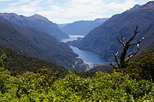 Doubtful Sound
Politically, Southland proper extends from
Fiordland
in the west past the
Mataura River
to the
Catlins
the east. To the north, Southland is framed by the Darran and Eyre Mountains. Farther south lies Stewart Island which is separated from the mainland by the
Foveaux Strait
.
Southland contains New Zealand's highest waterfall?the
Browne Falls
.
Lake Hauroko
is the deepest lake in the country. The highest peak in Southland is
Mount T?toko
, which is part of the Darran mountains. The largest lake in Southland is
Lake Te Anau
followed by
Lake Manapouri
which both lie within the boundaries of
Fiordland National Park
. Established on 20 February 1905, it is the largest national park in New Zealand?covering much of Fiordland which is devoid of human settlement.
[25]
Fiordland's terrain is dominated by mountains,
fiords
and
glacial lakes
carved up by
glaciations
during the last ice age, between 75,000 and 15,000 years ago. The region's coast is dotted by several fiords and other sea inlets which stretch from
Milford Sound
in the north to
Preservation Inlet
to the south. Farther north and east in Fiordland lie the
Darran
and
Eyre Mountains
which are part of the block of
schist
that extends into neighbouring
Central Otago
.
[9]
Farther east of the
Waiau River
, the
Southland Plains
predominate which include some of New Zealand's most fertile farmlands. The region's two principal settlements
Invercargill
and
Gore
are located on the plains. The plains extend from the
Waiau River
in the west to the
Mataura River
to the east. It can be divided into three broad areas: the Southland plain proper, the
Waimea Plains
and the lower Waiau plain to the west near the Waiau river.
[9]
The southern part of these plains (including the
Awarua Plains
along the coast east of
Bluff
) contains much
wetland
and swamp.
In the far southeast of Southland rises the rough hill country of
the Catlins
. This area is divided between Southland and the neighbouring
Otago
region, with the largest settlement,
Owaka
, being within Otago. The hills of the Catlins form part of a major
geological fold
system, the
Southland Syncline
, which extends from the coast northwestward, and include the
Hokonui Hills
above Gore.
Off the coast of Southland lies the
Great South Basin
which stretches over 500,000 square kilometres (190,000 sq mi)?an area 1.5 times New Zealand's land mass). It is one of the country's largest undeveloped offshore petroleum basins with prospects for both
oil and gas
.
Climate
[
edit
]
Weather conditions in Southland are cooler than the other regions of New Zealand due to its distance from the
equator
. However, they can be broken down into three types: the temperate oceanic climate of the coastal regions, the semi-continental climate of the interior and the wetter mountain climate of
Fiordland
to the west. Due to its closer proximity to the South Pole, the
Aurora Australis
or "Southern Lights" are more commonly seen than in other regions.
The coastal regions have mild summers and cool winters. The mean daily temperature varies from 5.2 °C in July to 14.9 °C in January. Rainfall varies from 900 mm to 1300 mm annually with rainfall being more frequent in coastal areas and rainbows being a regular occurrence in the region. Summers are temperable with downpours and cold snaps not being uncommon. On 7 January 2010,
Invercargill
was hit by a hail storm with temperatures plummeting rapidly from 15 °C to 8 °C in the afternoon.
[26]
Occasionally, temperatures exceed 25 °C with an extreme temperature of 33.8 °C having been reached before in Invercargill in 1948
[27]
and 35.0 °C in
Winton
in 2018.
[28]
Winters are colder and more severe than other regions, although not by much. The mean maximum temperature in July is 9.5 °C and Southland's lowest recorded temperature was ?18 °C in July 1946.
[29]
Snow and frost also frequently occur in inland areas but are less common and extreme in coastal areas where the oceans act as a moderating factor. The long-lasting cool and wet conditions are influenced by the presence of a stationary low-pressure zone to the southeast of the country.
Fiordland has a wet mountain climate though conditions vary due to altitude and exposure. Rainfall is the highest in the country and varies between 6,500 and 7,500 mm annually. The farthest coastal reaches of Fiordland are characterized by a limited temperature range with increasing rainfall at higher altitudes. The moist wet climate is influenced by approaching low-pressure systems which sweep across the country entering Fiordland.
[25]
Demographics
[
edit
]
Southland Region covers 31,218.27 km
2
(12,053.44 sq mi).
[1]
It has an estimated population of 103,900 as of June 2023, 2.0% of New Zealand's population.
[2]
It is the country's second-most sparsely populated region (after the
West Coast
), with 3.33 people per square kilometre (8.63 per square mile).
Ethnicities, 2023 Census
| Ethnicity
|
Population
|
| New Zealand European
|
|
| M?ori
|
|
| Pasifika
|
|
| Asian
|
|
| MELAA
|
|
| Other
|
|
Historical population
| Year
| Pop.
| ±% p.a.
|
|---|
| 1991
| 99,954
| ?
|
|---|
| 1996
| 97,098
| ?0.58%
|
|---|
| 2001
| 91,002
| ?1.29%
|
|---|
| 2006
| 90,876
| ?0.03%
|
|---|
| 2013
| 93,342
| +0.38%
|
|---|
| 2018
| 97,467
| +0.87%
|
|---|
| 2023
| 100,143
| +0.54%
|
|---|
| Source: Statistics NZ
[30]
[31]
|
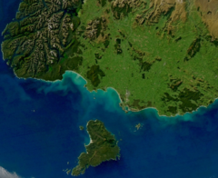 Satellite image of most of New Zealand's Southland Region, including Stewart Island and southern Fiordland.
Southland had a population of 100,143 in the
2023 New Zealand census
, an increase of 2,676 people (2.7%) since the
2018 census
, and an increase of 6,801 people (7.3%) since the
2013 census
. There were 46,761 dwellings. The median age was 40.4 years (compared with 38.1 years nationally). There were 18,921 people (18.9%) aged under 15 years, 17,211 (17.2%) aged 15 to 29, 45,495 (45.4%) aged 30 to 64, and 18,516 (18.5%) aged 65 or older.
Ethnicities were 84.1% European/
P?keh?
, 16.8%
M?ori
, 3.3%
Pasifika
, 7.1%
Asian
, 1.0% Middle Eastern, Latin American and African New Zealanders, and 1.5% other ethnicities. People may identify with more than one ethnicity.
[31]
Southland Region had a population of 97,467 at the
2018 New Zealand census
. There were 38,646 households. There were 48,705 males and 48,765 females, giving a sex ratio of 1.0 males per female.
The percentage of people born overseas was 12.2, compared with 27.1% nationally.
Although some people objected to giving their religion, 50.7% had no religion, 38.5% were Christian, 0.6% were Hindu, 0.3% were Muslim, 0.4% were Buddhist and 2.0% had other religions.
Of those at least 15 years old, 11,004 (14.1%) people had a bachelor or higher degree, and 19,770 (25.3%) people had no formal qualifications. The median income was $32,100, compared with $31,800 nationally. 10,920 people (14.0%) earned over $70,000 compared to 17.2% nationally. The employment status of those at least 15 was that 40,965 (52.5%) people were employed full-time, 12,153 (15.6%) were part-time, and 2,427 (3.1%) were unemployed.
[32]
A relatively high proportion of nineteenth century migrants came from Scotland and Ireland.
[7]
M?ori are largely concentrated around the port of Bluff.
[33]
During the 1940s, the development of the freezing works boosted a short-term immigration to the region by North Island M?ori.
[34]
In the 21st century the Asian-origin population of Southland increased owing to the recruitment of dairy workers, many of them from the Philippines. In 2013 the population of Asian origin accounted for 3.2% of the Southland total.
[35]
[36]
The West Coast aside, Southland has New Zealand's strongest regional identity. It is the only part of New Zealand which has a distinct regional accent (shared with most rural parts of Otago), characterized in particular by a rolling 'r'.
[37]
Food-wise, cheese rolls are a Southland specialty
[38]
and swedes are a popular vegetable, prepared and eaten as are pumpkin and kumara (sweet potato) elsewhere in New Zealand.
[39]
For many years a television channel, known as Southland TV from 2003?07, later
Cue TV
, transmitted Southland content. The strength of Southland identity may owe something to the relatively high proportion of New Zealand-born in the region ? 85% compared with 70% for New Zealand as a whole at the 2013 census.
[40]
Cities and towns
[
edit
]
With a population of 51,000
Invercargill
, the region's main centre and seat of local government, makes up half of Southland's total. Six other centres have populations over 1,000:
Gore
,
Mataura
,
Winton
,
Riverton
,
Bluff
and
Te Anau
.
[33]
Most of Southland's population is concentrated on the eastern
Southland Plains
.
Fiordland
, the western part of the region, is almost totally devoid of permanent human settlement.
Economy
[
edit
]
 Fiordland National Park
The subnational gross domestic product (GDP) of Southland was estimated at NZ$6.36 billion in the year to March 2019, 2.1% of New Zealand's national GDP. The subnational GDP per capita was estimated at $63,084 in the same period. In the year to March 2018, primary industries contributed $1.35 billion (22.4%) to the regional GDP, goods-producing industries contributed $1.52 billion (25.2%), service industries contributed $2.63 billion (43.7%), and taxes and duties contributed $516 million (8.6%).
[41]
The region's economy is based on agriculture, tourism, fishing,
forestry
and energy resources like coal and
hydropower
.
[10]
The agriculture industry includes both
sheep
and
dairy farming
which both account for a significant proportion of the region's revenue and export receipts. Much of this farming is on the
Southland Plains
, with expansion into the more remote western regions since the 1950s and 1960s.
[42]
Southland also has the world's largest raw milk-processing plant at the town of
Edendale
which was established by
Fonterra
.
[21]
In the 2019-20 season, there were 591,600 milking cows in Southland, 12.0% of the country's total herd. The cows produced 247,230 tonnes of milk solids, worth $1,780 million at the national average farmgate price ($7.20 per kg).
[43]
Other sizeable industries in Southland include coal and
hydroelectric
power.
[10]
Eastern Southland has significant deposits of
lignite
which are considered to be New Zealand's biggest fossil fuel energy resource.
[44]
Solid Energy
operated open cast lignite mines at Newvale and
Ohai
until its 2015 bankruptcy.
Southland hosts the nation's largest
hydroelectric power station
at
Manapouri
which is owned by
Meridian Energy
and powers the
Tiwai Point Aluminium Smelter
. The Manapouri project generated much controversy from environmental groups which initiated the
Save Manapouri Campaign
in opposition to rising water levels in nearby lakes.
Tourism spending is a major factor of the Southland economy, with NZ$595 million being spent by visitors in 2016, of which $210 million was spent in the
Fiordland
area.
[45]
In July 2007 the New Zealand Government awarded oil and gas exploration permits for four areas of the
Great South Basin
. The three successful permit holders were
ExxonMobil
New Zealand,
OMV
and
Greymouth Petroleum
.
[46]
See also
[
edit
]
References
[
edit
]
- ^
a
b
"ArcGIS Web Application"
.
statsnz.maps.arcgis.com
. Retrieved
27 February
2022
.
- ^
a
b
c
"Subnational population estimates (RC, SA2), by age and sex, at 30 June 1996-2023 (2023 boundaries)"
.
Statistics New Zealand
. Retrieved
25 October
2023
.
(regional councils);
"Subnational population estimates (TA, SA2), by age and sex, at 30 June 1996-2023 (2023 boundaries)"
.
Statistics New Zealand
. Retrieved
25 October
2023
.
(territorial authorities);
"Subnational population estimates (urban rural), by age and sex, at 30 June 1996-2023 (2023 boundaries)"
.
Statistics New Zealand
. Retrieved
25 October
2023
.
(urban areas)
- ^
"Regional gross domestic product: Year ended March 2022"
.
Statistics New Zealand
. 24 March 2023
. Retrieved
4 April
2023
.
- ^
"Sub-national HDI ? Area Database ? Global Data Lab"
.
hdi.globaldatalab.org
. Retrieved
13 September
2018
.
- ^
Grant, David (8 September 2008).
"Southland region: Early settlement"
. Te Ara: The Encyclopedia of New Zealand
. Retrieved
22 May
2024
.
- ^
a
b
c
Te R?nanga o Ng?i Tahu.
"Ng?i Tahu ? the iwi"
. Retrieved
14 June
2019
.
- ^
a
b
c
Grant, David (2 March 2009).
"Southland region: Society and culture"
. Te Ara: The Encyclopedia of New Zealand
. Retrieved
24 September
2017
.
- ^
Edie, Robyn; Taonga, New Zealand Ministry for Culture and Heritage Te Manatu.
"Venture Southland"
.
teara.govt.nz
. Retrieved
2 January
2023
.
- ^
a
b
c
Grant, David (24 November 2009).
"Southland region: Geology and landforms"
. Te Ara: The Encyclopedia of New Zealand
. Retrieved
18 January
2010
.
- ^
a
b
c
d
Grant, David (2 March 2009).
"Southland region: Overview"
. Te Ara: The Encyclopedia of New Zealand
. Retrieved
18 February
2010
.
- ^
Wright (2009), p. 61
- ^
a
b
Stevens, Michael J.
"K? Whare M?ori ki Awarua: Bluff's "M?ori Houses"
"
.
Te Karaka
. Te R?nanga o Ng?i Tahi
. Retrieved
14 June
2019
.
- ^
"Hone T?hawaiki"
.
New Zealand History
. Manat? Taonga: Ministry for Culture and Heritage
. Retrieved
14 June
2019
.
- ^
O'Regan, Hana.
"T?hawaiki"
.
Kotahi Mano K?ika
. Te R?nanga o Ng?i Tahu
. Retrieved
14 June
2019
.
- ^
Wright (2009), p. 140
- ^
Te R?nanga o Ng?i Tahu.
"The Murihiku Deed of 1853"
. Retrieved
14 June
2019
.
- ^
King (2003), p. 170
- ^
Wright (2009), p. 237
- ^
"New Zealand provinces 1848?77"
.
rulers.org
.
- ^
King (2003), p. 238
- ^
a
b
Hotton, Mike (26 September 2009).
"New milk dryer makes Edendale processor 'world's biggest'
"
.
The Southland Times
. Retrieved
4 October
2009
.
- ^
Grant, David (2 March 2009).
"Southland region: Government, education and health"
. Te Ara: The Encyclopedia of New Zealand
. Retrieved
2 September
2020
.
- ^
"New Zealand Parliament - Tirikatene, Rino"
. Archived from
the original
on 6 March 2013
. Retrieved
11 December
2012
.
- ^
"About Venture Southland"
. Venture Southland
. Retrieved
14 March
2013
.
- ^
a
b
Russell Kirkpatrick,
Contemporary Atlas of New Zealand: The Shapes of our Nation
, Auckland, NZ: David Bateman Ltd, 2005 (
ISBN
1-86953-597-9
), Plates 13, 32
- ^
Guyton, Saelyn (8 January 2010).
"Fire Service stretched as hail, rain pummel Invercargill"
.
Otago Daily Times
. Retrieved
8 January
2010
.
- ^
"A Bit of a Breather!"
? 26 November 2008 -weatherwatch.co.nz. ? Retrieved 13 December 2010.
- ^
"New Zealand Climate Summary: Summer 2017?18"
(PDF)
.
NIWA
. Retrieved
20 August
2018
.
- ^
Grant, David (2 March 2009).
"Southland region ? Climate"
. Te Ara ? the Encyclopedia of New Zealand
. Retrieved
8 January
2010
.
- ^
"2001 Census: Regional summary"
.
archive.stats.govt.nz
. Retrieved
28 April
2020
.
- ^
a
b
"2023 Census national and subnational usually resident population counts and dwelling counts"
(Microsoft Excel)
. Stats NZ - Tatauranga Aotearoa
. Retrieved
29 May
2024
.
- ^
"Statistical area 1 dataset for 2018 Census"
. Statistics New Zealand. March 2020. Southland Region (15).
2018 Census place summary: Southland Region
- ^
a
b
Grant, David (2 March 2009).
"Southland region: Southland people"
. Te Ara: The Encyclopedia of New Zealand
. Retrieved
18 February
2010
.
- ^
[./Michael_King_(historian) Michael King],
The Penguin History of New Zealand
, Auckland, NZ: Penguin Books (NZ) Ltd, 2003 (
ISBN
0-14-301867-1
), Pp 170, 202, 238, 473
- ^
"2013 Census QuickStats about a place"
.
- ^
"Invercargill and Southland ? ANZF Reporting"
.
www.asianz.org.nz
.
- ^
David Grant, 'Southland region ? Overview', Te Ara ? the Encyclopedia of New Zealand,
http://www.TeAra.govt.nz/en/video/20079/a-rolling-r
(accessed 24 September 2017)
- ^
"Southland Cheese Rolls"
. 10 August 2014.
- ^
https://David
Grant, 'Southland region ? Farming: 1950s to present day', Te Ara ? the Encyclopedia of New Zealand,
http://www.TeAra.govt.nz/en/photograph/20122/swedes-for-sale
(accessed 24 September 2017)
- ^
"Tables about a place"
. Archived from
the original
on 24 September 2017
. Retrieved
24 September
2017
.
- ^
"Regional gross domestic product: Year ended March 2019 | Stats NZ"
.
www.stats.govt.nz
. Retrieved
21 May
2020
.
- ^
Grant, David (2 March 2009).
"Southland region: Farming: 1950s to present day"
. Te Ara: The Encyclopedia of New Zealand
. Retrieved
18 February
2010
.
- ^
"New Zealand Dairy Statistics 2019-20"
.
www.dairynz.co.nz
. Retrieved
8 March
2021
.
- ^
Alan Sherwood and Jock Phillips (2 March 2009).
"Coal and coal mining ? Coal resources"
.
Te Ara: The Encyclopedia of New Zealand
. Ministry for Culture and Heritage /
Te Manatu Taonga
. Retrieved
13 December
2010
.
- ^
Milford Sound Transport ? Issues and Options
Archived
27 September 2007 at the
Wayback Machine
(GHD Ltd for Venture Southland, 2005)
- ^
"Southland Energy Consortium"
. Energy.southlandnz.com
. Retrieved
2 August
2010
.
External links
[
edit
]
Wikivoyage has a travel guide for
Southland
.
|
|---|
| International
| |
|---|
| National
| |
|---|
| Geographic
| |
|---|
45°42′S
168°06′E
/
45.7°S 168.1°E
/
-45.7; 168.1