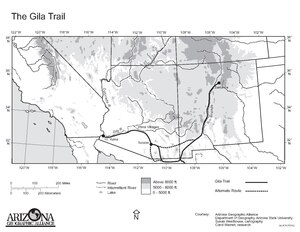
19th-century immigrant route in the United States
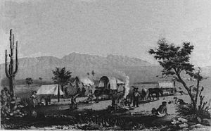 An American wagon train at
Maricopa Wells
in 1857
An American wagon train at
Maricopa Wells
in 1857
- The Southern Emigrant Trail should not be confused with the
Applegate Trail
, which is part of the
Northern Emigrant Trails
.
Southern Emigrant Trail
, also known as the
Gila Trail
, the
Kearny Trail
,
Southern Trail
and the
Butterfield Stage Trail
, was a major land route for immigration into
California
from the eastern United States that followed the
Santa Fe Trail
to
New Mexico
during the
California Gold Rush
. Unlike the more northern routes, pioneer wagons could travel year round, mountain passes not being blocked by snows; however, it had the disadvantage of summer heat and lack of water in the desert regions through which it passed in
New Mexico Territory
and the
Colorado Desert
of California. Subsequently, it was a route of travel and commerce between the eastern United States and California. Many herds of cattle and sheep were driven along this route and it was followed by the
San Antonio-San Diego Mail Line
in 1857?1858 and then the
Butterfield Overland Mail
from 1858 to 1861.
History of the Route
[
edit
]
1846?1848: Kearney, Cooke, and Graham
[
edit
]
In October 1846, General
Stephen Watts Kearny
and his dragoons with their scout
Kit Carson
found the route over the mountains from the
El Camino Real de Tierra Adentro
on the
Rio Grande
, via the
Santa Rita
mines to the
Gila River
which he then followed to the Colorado River, at the
Yuma Crossing
where he crossed the river and then the Colorado Desert to
Southern California
. This was known as the
Gila Trail
.
One month later, Colonel
Philip St. George Cooke
and the
Mormon Battalion
with wagons Kearny could not take across the mountains of New Mexico, followed a route south along the west bank of the Rio Grande from where Kearny had left the river, to a point just north of what later became the site of
Fort Thorn
. There Cooke left the Rio Grande, establishing a wagon road that reached far southwest through the
Guadalupe Pass
and then west just south of the current border with Mexico then west to and beyond modern
Agua Prieta
, before turning northward via the
San Pedro River
, then west to
Tucson
. Linking there with the
Sonora Road
to California established by
Juan Bautista de Anza
in 1774, they marched on a three-day journey north over the desert before linking up with Kearny’s route on the Gila River just east of the
Pima Villages
. Cooke followed the Anza?Kearny route westward along the Gila to
Yuma Crossing
where it had its junction with the
El Camino del Diablo
an old Spanish route reestablished by Mexico from 1828. This established the first southern wagon road from New Mexico to California.
[1]
This new wagon route became known as
Cooke's Road
, or
Sonora Road
, as much of the central part of the route passed through what was then the northern frontier of the state of
Sonora, Mexico
.
In 1848, a U.S. Army expedition of
1st Dragoons
under Major
Lawrence P. Graham
marched from
Chihuahua
to California, through
Janos
, then westward to strike Cooke's road at
Guadalupe Pass
. He then followed Cooke's wagon route along the Mexican border region but went farther west beyond the San Pedro River along an older Spanish trail to the headwaters of the
Santa Cruz River
which he followed to the Sonoran town of
Santa Cruz
then turned north on the old Spanish road to Tucson along the Santa Cruz River. Graham's detour, known as
Major Graham's Road
, would be taken by most of the
Forty-niners
following Cooke's route the next year, despite its greater distance.
[2]
From Yuma Crossing the Southern Emigrant Trail crossed the
Colorado Desert
, dipping south along the Colorado River, into
Baja California
,
Mexico
, (avoiding the vast
Algodones Dunes
to the west and northwest), to follow the waterholes along the
Alamo
and
New Rivers
, then northwest into California again across the desert to Carrizo Creek and the oasis at
Vallecito
.
 Remains of the Southern Emigrant Trail at Warner's Ranch in 2017
From Vallecito the trail then ran northwest into the
Peninsular Ranges
crossing
Warners Pass
to
Warner's Ranch
. From Warner's the road then ran either northwest to Los Angeles, (via
Temecula
,
La Laguna
,
Temescal
,
Chino
,
La Puente
and
San Gabriel
) or west southwest to San Diego via
Santa Ysabel
,
San Pasqual
and
Rancho Penasquitos
.
[3]
[4]
[5]
From either of these towns the traveler could continue north by land to the gold fields on the coast via the
El Camino Real
or over the
old Tejon Pass
into the
San Joaquin Valley
and then north by what would later become the
Stockton?Los Angeles Road
or via the
El Camino Viejo
. Alternatively they could take ships to
San Francisco
from San Diego or
San Pedro
.
1849?1854: Tucson Cutoff
[
edit
]
Subsequently, the distance of the Cooke?Graham route was drastically shortened by the
Tucson Cutoff
pioneered by
John Coffee Hays
with a party of forty-niners in late 1849. This route avoided the long distance traveled to the south by passing through
Stein's Pass
,
Apache Pass
and
Nugent’s Pass
, then down
Tres Alamos Wash
to the
Lower Crossing of the San Pedro River
below
Tres Alamos
. From there it linked up with Cooke's Wagon Road at a waterhole, near modern
Mescal
.
[6]
[7]
1855 to the 1880s: Dragoon Pass, Pacific Wagon Road, Doubtful Canyon Cutoff
[
edit
]
Dragoon Pass and the Pacific Wagon Road
[
edit
]
In 1856, a Railroad Survey Expedition modified the Tucson Cutoff route, passing south of Nugent's Pass using
Dragoon Pass
and the
Middle Crossing or San Pedro Crossing
of the river instead of the Lower Crossing below Los Alamos.
[8]
In 1857 following the
Gadsden Purchase
, as part of the
Pacific Wagon Road
, a military road being built between El Paso and Fort Yuma, a wagon road was built from
Mesilla
westward to
Cooke's Spring
, saving the longer route via the San Diego Crossing. The Pacific Wagon Road then followed Cooke's Wagon Road and the Tucson Cutoff as far as the west side of the Apache Pass. There it made another shortcut across
Sulphur Springs Valley
to
Dragoon Pass
, and then down
Dragoon Wash
to the San Pedro River. The route then descended northward on the right bank of the river to the
Middle Crossing of the San Pedro River
. From this crossing the Pacific Wagon Road ran due west to link up again with Cooke's Wagon Road at Mescal Springs to continue on to
Tucson, Arizona
, then turned northward to the
Pima Villages
and
Maricopa Wells
where it turned westward along the
Gila River
following it to the ferries on the
Colorado River
across from
Fort Yuma
. The Pacific Wagon Road shortened the route still further for travelers.
Doubtful Canyon Cutoff
[
edit
]
From 1859 to 1861, during the time of the
Butterfield Overland Mail
, the stages and other traffic ran over a shortcut between
Ojo de Vaca
and Apache Pass, over the
Peloncillo Mountains
through
Doubtful Canyon
. However following the destruction of stage stations and coaches and the killing of their keepers and drivers at the outbreak of war with the
Apache
in 1861, this route was abandoned. Favored ambush country, the shortcut was unwise to use unless the travelers were a strong detachment of soldiers or under military escort by one. Even so, in May 1864,
California Volunteers
fought a
Skirmish in Doubtful Canyon
with Apache that tried to ambush them there. Traffic returned to the Pacific Wagon Road route which then remained a primary east?west route in the southwest until the advent of the railroads in the 1880s.
References
[
edit
]
- ^
Philip St. George Cooke, The Conquest of New Mexico and California, G. P. Putnam's Sons, New York, 1878 pp. 91?109, 125?196
- ^
Harlan Hague, The Search for a Southern Overland Route to California, California Historical Quarterly, Summer 1976, (pp. 150?161)
- ^
Randolph B. Marcy, Captain U. S. Army,
The Prairie Traveler. A Hand-Book For Overland Expeditions. With maps, illustrations, and itineraries of the Principal Routes between the Mississippi and the Pacific
, Published by Authority of the War Department, New York, Harper & Brothers, Publishers, Franklin Square, 1859. List of Itineraries, XIV. Wagon-road from San Antonio, Texas, to El Paso, N.M., and Fort Yuma, Cal.
- ^
Marcy,
The Prairie Traveler
..., List of Itineraries, XV.?From Fort Yuma to San Diego, California.
- ^
Marcy,
The Prairie Traveler
..., List of Itineraries, XXI.?From Fort Yuma to Benicia, California
- ^
Robert Eccleston, Overland to California on the Southwestern Trail 1849, University of California Press, Berkeley, 1950, pp. 174?193
- ^
Richard J. Hinton,
The Handbook to Arizona: Its Resources, History, Towns, Mines, Ruins, and Scenery
, Payot, Upham & Company, 1878
pp. xix?xx, xxxi
- ^
Report of Captain A. A. Humphreys, Topographical Engineers, Upon the progress of the Pacific Railroad Expeditions and Surveys, Report of the Secretary of War, Dec. 1, 1856, Message from the President of the United States to the Two Houses of Congress at the Commencement of the third session of the 34th Congress, 34th Congress, 3d Session, House of Representatives, Ex. Doc. No.1, Vol. II, Cornelius Wendell, Washington, 1856, pp. 206?209